Chapter 1: India – Location
At the far eastern edge of India, in Arunachal Pradesh, the sun clears the horizon and the day begins. Nearly two hours pass before that same sunrise reaches Jaisalmer, out in the western sands of Rajasthan. The Earth turns from west to east, so the lands that lie furthest east always meet the sun first. India is wide — its eastern and western ends are separated by close to thirty degrees of longitude — and thirty degrees of turning takes the planet about two hours.
And yet, if you telephoned a friend in Dibrugarh in the east while standing in Bhopal near the centre, both watches would read exactly the same time. A clock in Imphal and a clock in Chennai agree to the minute, though the sun visits them hours apart. This is not an accident of habit. A country this broad could have run on many local times, each town keeping its own noon. Instead India fixed a single line of longitude, 82°30’ E, and declared that the whole nation would keep the time of that one meridian.
Behind that decision sits a larger truth about the country. India is vast, and its position on the globe shapes almost everything about it — how long its days feel, how its seasons fall, how its coasts face the sea, and which neighbours lie across its borders.
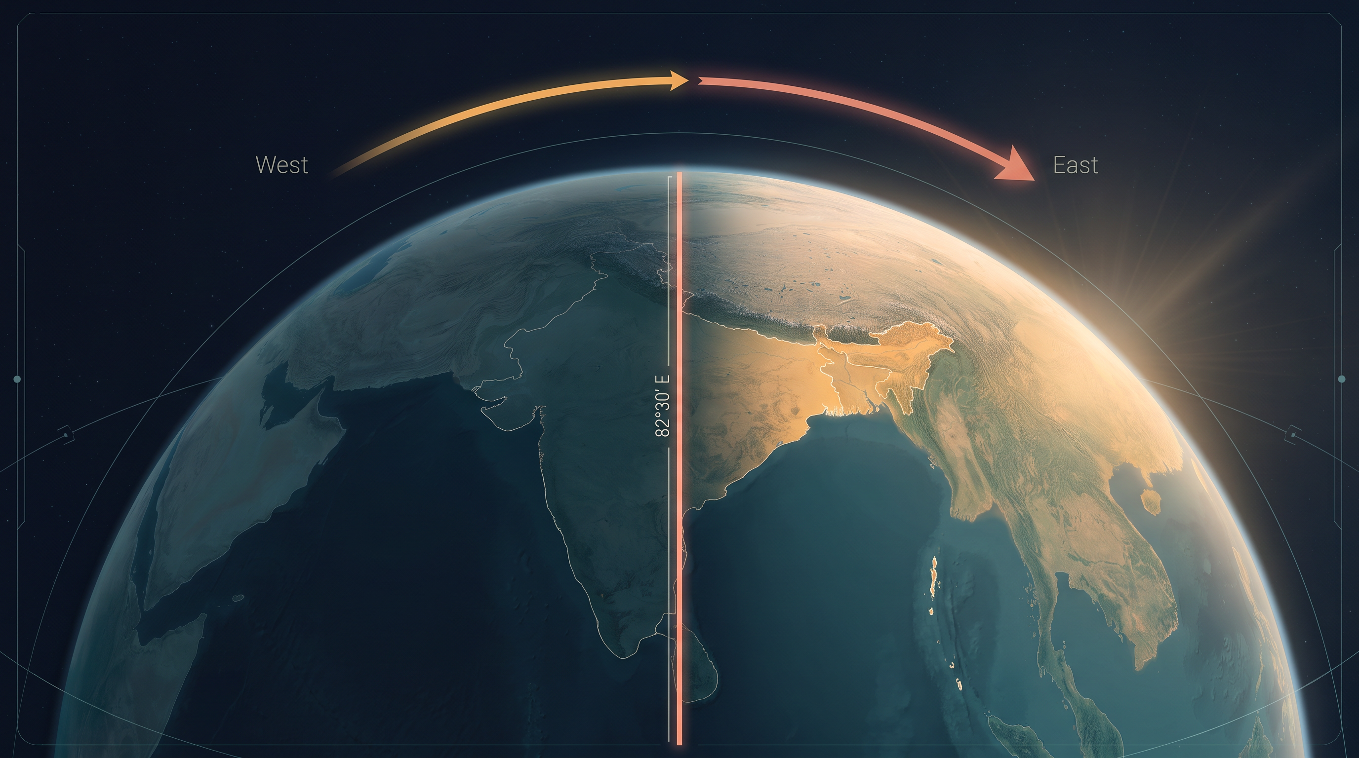
Fig. 1.0 – India’s east–west extent and the advancing sunrise.
1.1 Location And Extent
You have looked at the map of India in earlier classes. Now look at it closely and give it the attention a geographer gives a map. On the map in Fig. 1.1, find and mark the country’s northernmost and southernmost points of latitude, and its easternmost and westernmost points of longitude. Where a country sits on the globe decides a great deal about it, so this is where the study of India begins.
Map
Fig. 1.1 Caption: The administrative divisions of India — its states, union territories and their boundaries. Brief: Reproduce the NCERT administrative map showing the full extent of India as officially defined. Label all states and union territories, the international and state boundaries as keyed, the surrounding seas and neighbouring countries, and the Tropic of Cancer where it crosses the country. Include the graphical scale bar and the latitude–longitude grid along the margins.
The Reach Of The Mainland
The mainland of India stretches from Kashmir in the far north to Kanniyakumari, the southern tip of the peninsula, and from Arunachal Pradesh in the east to Gujarat on the western coast. These four names mark the outer corners of a very large country.
A country’s edge does not stop at its coastline. India’s territorial limit — the belt of sea a country counts as its own — reaches a further 12 nautical miles, about 21.9 km, out from the coast. A nautical mile is the unit of distance used at sea; it is about 1.852 km, a little longer than the ordinary statute mile of about 1.584 km. In inches, a statute mile measures 63,360 and a nautical mile 72,960. Counting this maritime belt, the country’s southern boundary reaches down to 6°45’ N latitude in the Bay of Bengal.
Why Degrees And Distance Disagree
Work out India’s extent in degrees and you find it is roughly 30 degrees from north to south and about the same from east to west. Yet the two are not equal on the ground. The actual distance from the northern to the southern extremity is 3,214 km, while from east to west it is only 2,933 km. The same 30 degrees measures out to a different distance depending on which way you turn. Why?
The answer lies in how the grid of the globe is built. Lines of latitude — the parallels — stay the same distance apart everywhere, from the equator to the poles. Lines of longitude — the meridians — do not. They fan out widest at the equator and crowd together as they run towards the poles, meeting at a single point at each pole. So a degree of latitude keeps a steady length, while a degree of longitude shrinks the further you go from the equator. India lies north of the equator, so its 30 degrees of longitude cover less ground than its 30 degrees of latitude.
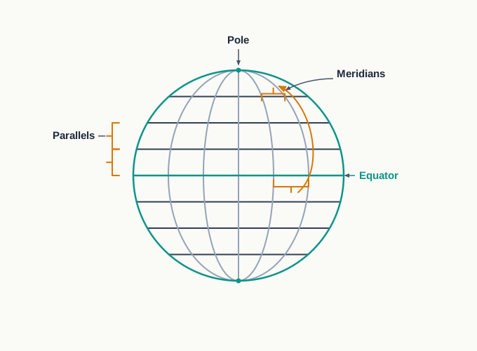
Fig. 1.2 – Spacing of parallels and meridians on the globe.
You can test the first half of this for yourself: work out the ground distance between any two lines of latitude and you will find it holds steady wherever you measure it. The reasoning behind these figures is set out in Chapter 3, on latitude, longitude and time, in the companion book Practical Work in Geography – Part I.
Latitude And The Shape Of The Land
Where a place sits in latitude decides how much of the sun’s heat it receives, and that shapes everything living on it. The Tropic of Cancer, marked across the middle of India on Fig. 1.1, divides the country in two. The southern part lies within the tropics, where the sun is strong and the year is warm; the northern part lies beyond, in the sub-tropical or warm temperate zone, where the seasons swing more sharply between hot and cold.
This split in latitude is one reason India holds such variety. It is responsible for the large differences you find across the country in its landforms, its climate, its soil types and its natural vegetation. A single figure of latitude, in other words, is quietly setting the stage for the whole physical geography of the land.
Longitude, Time And One Clock
Now turn from latitude to longitude and its effect on daily life. India’s 30 degrees of longitude produce a difference of nearly two hours in local sun-time between the easternmost and the westernmost parts of the country. The sun rises in the north-eastern states about two hours earlier than it does at Jaisalmer, far to the west. Where does that two hours come from?
This two-hour gap is exactly why India keeps a single clock rather than many. If every town ran on its own sun-time, a railway timetable or a radio schedule would be a tangle of slightly different local times. To avoid this, the country fixes all its clocks to one line of longitude. There is a general understanding among the countries of the world to choose this standard meridian — the single line of longitude whose time a whole country keeps — in multiples of 7°30’. India chose 82°30’ E, which is such a multiple and runs close to the centre of the country. Indian Standard Time is set 5 hours and 30 minutes ahead of Greenwich Mean Time. Some countries are too wide from east to west for one clock to serve; the United States, for example, keeps seven time zones.
This is why watches in Dibrugarh and Imphal in the east, and in Jaisalmer, Bhopal or Chennai further west, all read the same time, even though the sun reaches them hours apart. Trace the line 82°30’ E on Fig. 1.1 and name the states it crosses on its way south.
Set all of this against India’s place in the world as a whole. The country covers an area of 3.28 million sq. km, which accounts for 2.4 per cent of the world’s land surface, and it stands as the seventh largest country in the world. Only six countries are larger; using an atlas, find out which they are.
1.2 Size
A country’s size is not just a number on a page; it decides how much variety the land can hold. India is large enough to gather many kinds of landscape inside one border, and that is the first thing its size gives it.
A Land Of Many Landscapes
Because India is so big, it carries great physical diversity. In the north stand lofty mountains. Across the plains run large rivers — the Ganga, the Brahmaputra, the Mahanadi, the Krishna, the Godavari and the Kaveri. There are green forested hills in the north-east and in the south, and the vast sandy expanse of the Marusthali, the great desert of western Rajasthan whose name means ‘land of the dead’. No single one of these could stand for the whole country; together they show how much range one large landmass can hold.
You can read this diversity as a journey. By looking at a physical map of India, describe for yourself the changes in land you would pass through travelling from Kashmir in the north to Kanniyakumari in the south, and from Jaisalmer in Rajasthan to Imphal in Manipur. Each leg crosses a different world of rock, water and climate.
Map
Map 1.A1 Caption: The physical features named in this section — the northern and north-western ranges, the great rivers, the western desert and the mountain passes. Brief: On a physical map of India showing the full extent of India as officially defined, plot only the features named in this section: the Himalayas in the north, the Hindukush and Sulaiman ranges in the north-west, the Purvachal hills in the north-east, the Ganga, Brahmaputra, Mahanadi, Krishna, Godavari and Kaveri rivers, the Marusthali desert, and the passes Khyber, Bolan, Shipkila, Nathula and Bomdila. Do not add features the section does not name.
The Subcontinent And Its Wall
India does not sit alone; it is the heart of a larger natural region. Bounded by the Himalayas in the north, the Hindukush and Sulaiman ranges in the north-west, the Purvachal hills in the north-east, and the wide Indian Ocean in the south, this whole region forms a single great geographic entity known as the Indian subcontinent — a landmass so large and so clearly walled off that it is treated almost as a continent in its own right. It includes the countries Pakistan, Nepal, Bhutan, Bangladesh and India.
Those mountain walls did more than mark an edge; they shaped the region’s history. For long stretches of the past the ranges were a formidable barrier, and the subcontinent could be entered only through a few high passes — the Khyber, the Bolan, the Shipkila, the Nathula and the Bomdila among them. Because movement in and out was slow and filtered through these narrow gaps, the region grew, over centuries, into a distinct unit with a regional identity of its own.
A Long And Two-Sided Coast
The peninsular part of India reaches out into the Indian Ocean, giving the country a long coast on two seas. The mainland alone has a coastline of 6,100 km. Counting the entire geographical coast — the mainland together with the island groups — the figure rises to 7,517 km.
The gap between these two numbers is the work of the islands. Subtracting, \(7{,}517 - 6{,}100 = 1{,}417\) km of coast belongs to the fuller reckoning and the island territories: the Andaman and Nicobar Islands out in the Bay of Bengal to the east, and the Lakshadweep in the Arabian Sea to the west. Reaching into both seas at once, India is a physically diverse land, and that diversity is also a store of varied resources.
1.3 India And Its Neighbours
Location is not only about where a country sits, but about who lies around it and how easily they can be reached. Having looked at India’s own extent, turn now to its place among its neighbours.
A Maritime Position
Examine the location map in Fig. 1.3. India sits in the south-central part of the continent of Asia, facing the Indian Ocean, whose two arms reach up on either side of the peninsula as the Bay of Bengal to the east and the Arabian Sea to the west. This is a maritime location — a position defined by open sea on more than one side.
Map
Fig. 1.3 Caption: India’s position in the eastern world, with the sea and air routes that link it to other regions. Brief: Reproduce the NCERT map showing India within Asia and the wider eastern world, with the full extent of India as officially defined. Show the air routes as solid lines and the sea routes as dashed lines radiating from Indian cities across the Indian Ocean and beyond, with the surrounding countries and seas labelled and the graphical scale retained.
That maritime position has given peninsular India links to its neighbouring regions along sea and air routes running out in many directions. A country walled off by mountains on land can still reach the world across the water.
The Neighbours Across The Water
Some of India’s neighbours are not on land at all. Sri Lanka and Maldives are two island countries in the Indian Ocean that count as India’s neighbours — Sri Lanka lying off the south-eastern coast, and Maldives to the south-west. Sri Lanka is separated from India by the Gulf of Mannar and the Palk Strait.
Those two names describe two different shapes of water, and it is worth telling them apart. A gulf is a large stretch of sea that reaches into the land, held by coast on most sides but opening widely to the ocean — the Gulf of Mannar is one. A strait is a narrow channel of water that joins two larger water bodies and runs between two pieces of land — the Palk Strait, threading between India and Sri Lanka, is one. A gulf is broad and inlet-like; a strait is narrow and passage-like.
To picture the whole of India’s frontier, prepare a list of its neighbouring countries by consulting the maps in this chapter and an atlas. Using the School Bhuvan NCERT portal or an atlas, you can go further and gather information about the states, districts and villages that lie close to India’s international border.
Do Barriers Still Divide?
Once, high mountains made contact with neighbours slow and difficult. Ask yourself whether that physical barrier is still a real hindrance to interaction today, and find examples of how such difficulties have been overcome in the present day. The maritime and air links you saw on Fig. 1.3 are part of the answer: where the land closes a door, the sea and the sky open others.
1.4 Summary
India’s mainland reaches from Kashmir in the north to Kanniyakumari in the south, and from Arunachal Pradesh in the east to Gujarat in the west. Its territorial waters extend 12 nautical miles (about 21.9 km) out to sea, and the southern boundary runs down to 6°45’ N in the Bay of Bengal.
India’s extent is roughly 30 degrees both north–south and east–west, yet the ground distances differ: 3,214 km north–south against 2,933 km east–west. This is because meridians of longitude crowd together towards the poles, while parallels of latitude stay evenly spaced everywhere.
The Tropic of Cancer divides the country, placing the south within the tropics and the north in the sub-tropical or warm temperate zone. This latitudinal spread is a chief reason for India’s wide variety of landforms, climate, soils and natural vegetation.
The 30 degrees of longitude create a time difference of nearly two hours between the east and the west. To keep one clock, India uses Indian Standard Time based on the standard meridian 82°30’ E, set 5 hours and 30 minutes ahead of Greenwich Mean Time.
With an area of 3.28 million sq. km — 2.4 per cent of the world’s land and the seventh largest country — India holds great physical diversity: lofty mountains, large rivers, forested hills and the sandy Marusthali.
Ringed by the Himalayas, the Hindukush and Sulaiman ranges, the Purvachal hills and the Indian Ocean, and crossable only through a few passes such as the Khyber and the Nathula, the region forms the Indian subcontinent, with a distinct regional identity.
Its peninsular shape gives India a long coastline — 6,100 km on the mainland and 7,517 km counting the Andaman and Nicobar Islands and the Lakshadweep — and a maritime location that links it to its neighbours, including the island countries Sri Lanka and Maldives, by sea and air.
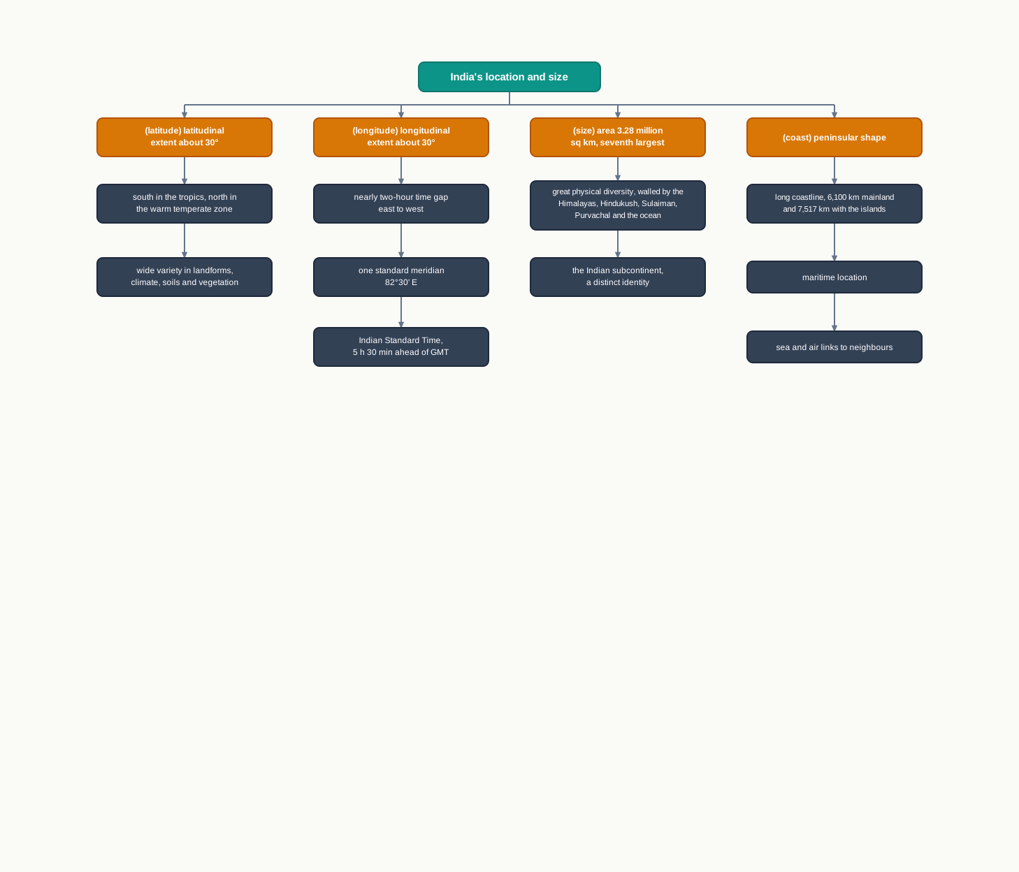
Fig. 1.4 – Effects of India’s location and size.
What This Chapter Cannot Tell You
The extent of a country in degrees and kilometres tells you how large and how varied it is, but not how that variety is arranged inside — where the desert yields to forest, or the plain rises into mountain.
Standard time keeps every clock in step, but it hides the real difference in sun-time across the country; the meridian is a convenience, not a record of when the sun actually rises at any place.
This chapter maps only India’s outer frame — its edges, its size and its neighbours. The working systems inside that frame, the monsoon and the rivers, the soils and the people, belong to the chapters that follow.
1.5 NCERT Questions
Which one of the following latitudinal extents is relevant for the extent of India’s area?
- 8°41’N - 35°7’N
- 8°4’N - 37°6’N
- 8°4’N - 35°6’N
- 6°45’N - 37°6’N
Which one of the following countries shares the longest land frontier with India?
- Bangladesh
- China
- Pakistan
- Myanmar
Which one of the following countries is larger in area than India?
- China
- Egypt
- France
- Iran
Which one of the following longitudes is the standard meridian for India?
- 69°30’E
- 82°30’E
- 75°30’E
- 90°30’E
Does India need to have more than one standard time? If yes, why do you think so? (about 30 words)
What are the implications of India having a long coastline? (about 30 words)
How is the latitudinal spread of India advantageous to her? (about 30 words)
While the sun rises earlier in the east, say Nagaland, and also sets earlier there, how do the watches at Kohima and New Delhi show the same time? (about 30 words)
Activity based on the Map of India / Atlas / Census. Teachers may help with these by explaining them and getting them done by the students.
On graph paper, plot the number of districts in Madhya Pradesh, Karnataka, Meghalaya, Goa, Kerala and Haryana. Does the number of districts have any relationship with the area of the state?
Which state among Uttar Pradesh, West Bengal, Gujarat, Arunachal Pradesh, Tamil Nadu, Tripura and Rajasthan is the most thickly populated, and which one is the least densely populated?
Identify the states with coastal boundaries.
Arrange the states that have only a land boundary from west to east.
List the Union Territories that have a coastal location.
How do you explain the variation in the area and population of NCT Delhi and the Andaman and Nicobar Islands?
On graph paper, draw a bar diagram to show the area and population of all the Union Territories.
1.6 Check Your Concepts
The mainland of India has a coastline of 6,100 km, while the entire geographical coast measures 7,517 km. Work out the difference between the two figures, and name the island groups that account for it.
The Tropic of Cancer is marked across India on Fig. 1.1. Using it, explain why the southern part of the country lies within the tropics while the northern part lies in the sub-tropical or warm temperate zone.
India’s extent is about 30 degrees both from north to south and from east to west, yet the north–south distance (3,214 km) is greater than the east–west distance (2,933 km). Explain why the same number of degrees gives a different distance.
The chapter states that India’s longitudinal extent of about 30 degrees produces a time difference of nearly two hours between its eastern and western edges. Show, step by step, how 30 degrees of longitude works out to about two hours.
Fig. 1.3 shows air routes and sea routes fanning out from India. What does the pattern of these routes suggest about India’s position in the world, and what does the map not tell you about the routes themselves?
Explain why India’s peninsular, maritime position is described as placing the country on the sea routes between the eastern and western worlds. Which single feature of its location is doing the most work?
The chapter names both the Gulf of Mannar and the Palk Strait, which separate India from Sri Lanka. Explain the difference between a gulf and a strait.