Chapter 6: Natural Hazards And Disasters
On the morning of 26 December 2004, the sea floor beneath the Indian Ocean lurched. A long stretch of the ocean bed, held under strain for a very long time where one plate grinds beneath another, snapped upward in seconds. The water resting above it had nowhere to go but out. The ocean does not compress; when its floor jumps, the whole column of water above is thrown into motion.
Far out in the deep ocean, this motion was almost invisible. A ship riding over it would have felt only a gentle swell, a rise of a metre or two spread across a wave many kilometres long. Nothing to fear. But the energy was travelling — silent, fast and enormous — toward every coast around the basin.
At the shore, the ocean floor shallows. The advancing wave, its base dragging on the rising seabed, was forced to slow and pile up. What had been a low swell at sea stood into a wall of water metres high and crashed over the coasts of Indonesia, Sri Lanka, Thailand and India. More than 300,000 people lost their lives that day.
No one had pushed the water. A movement of the Earth’s crust, hours earlier and an ocean away, had done all of it. This chapter is about changes like this one — the natural forces that turn, in moments, into disasters.
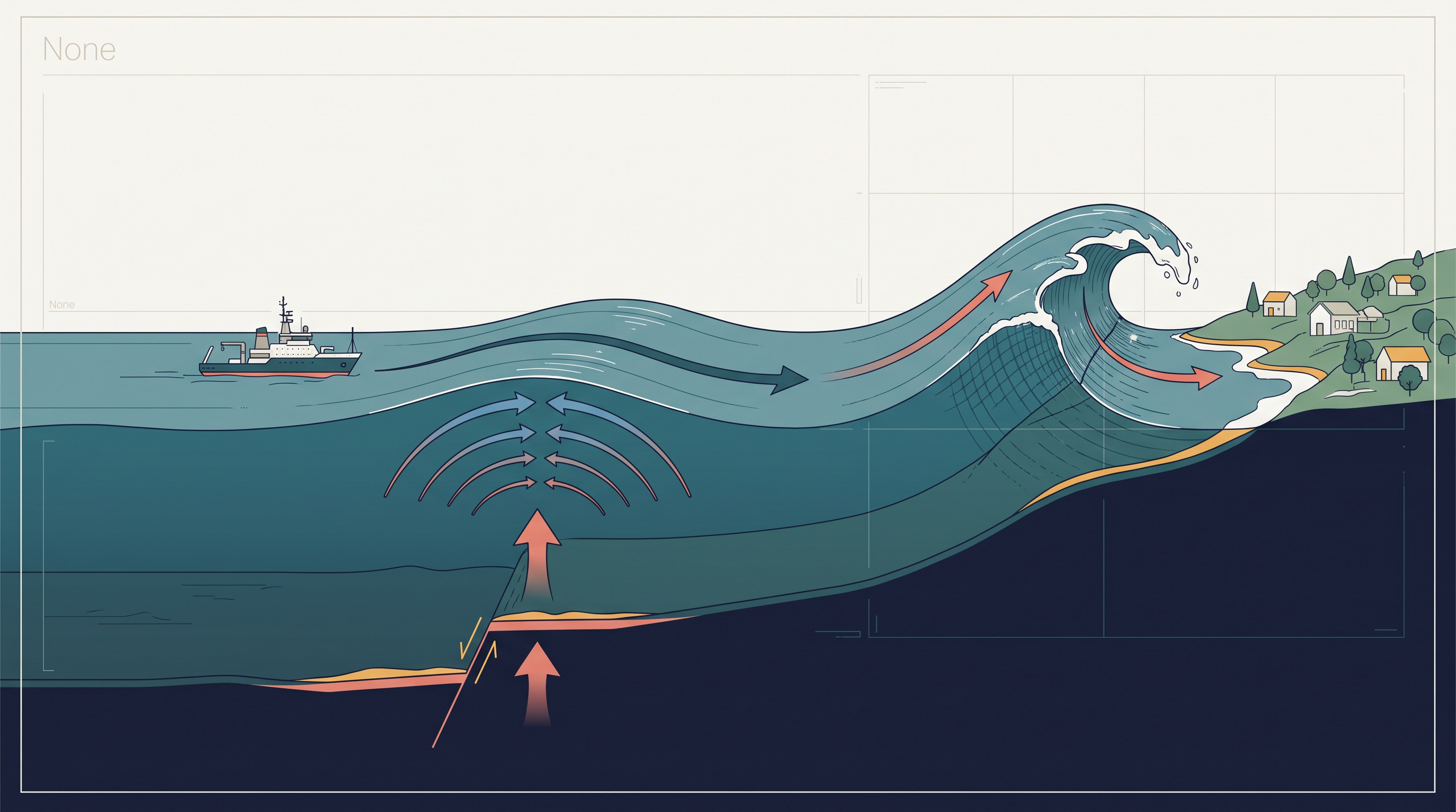
Fig. 6.0 – Tsunami wave height from deep sea to shallow coast.
6.1 Understanding Hazards And Disasters
You have seen images of a tsunami on television, or read about a severe earthquake in Kashmir that shook both sides of the Line of Control (LOC). The damage such events do to human life and property moves everyone who watches them. What are these events as phenomena? How are they caused, and how can we protect ourselves? This chapter sets out to answer questions like these.
Change And Its Many Faces
Change is the law of nature. It goes on without pause, in things big and small, material and non-material, that together make up our physical and social world.
Change varies in magnitude, intensity and scale. Some change is slow and gradual, like the evolution of landforms and living things. Some is sudden and swift — a volcanic eruption, a tsunami, an earthquake, a flash of lightning.
Change also varies in reach. A hailstorm, a tornado or a dust storm may last only seconds and cover a small patch of ground. Global warming and the thinning of the ozone layer, by contrast, act across the whole planet.
Look at the environment around you, and you can sort the changes you notice into two lists: those that unfold over a long time, and those that happen within a short one. Ask, too, why some changes are welcomed and others feared, and give your reasons — the exercise trains you to see change as a process, not just an event.
Change also means different things to different people, depending on the point of view one takes. From nature’s side, change is value-neutral — it is neither good nor bad, it simply happens. From the human side, change is value-loaded: we judge it. The turn of the seasons and the ripening of fruit feel good; earthquakes, floods and wars feel bad and unwanted. This chapter is about the changes we fear — the ones that have haunted humankind for a long time.
What Makes A Disaster
Disasters in general, and natural disasters in particular, are exactly such changes: always disliked, always feared. A disaster is an undesirable occurrence, driven by forces largely outside human control, that strikes quickly with little or no warning. It causes or threatens serious disruption of life and property, brings death and injury to a large number of people, and demands a response far beyond what statutory emergency services normally provide.
For a long time, geographical writing treated disasters as purely the work of natural forces, with human beings cast as innocent and helpless victims before the might of nature. That view is now known to be incomplete. Natural forces are not the only cause of disasters.
When People Are The Cause
Some human activities cause disasters directly. The Bhopal Gas tragedy, the Chernobyl nuclear disaster, wars, the release of CFCs (chlorofluorocarbons) and greenhouse gases, and the pollution of noise, air, water and soil are all disasters produced directly by human action.
Other human activities intensify disasters indirectly. Landslides and floods made worse by deforestation, by unscientific land use, and by construction in fragile areas are the result of what people do, not of nature acting alone. Look around your own neighbourhood and school, and you can name activities going on today that may lead to disasters tomorrow — and think of measures that could prevent them.
Human-made disasters have grown in both number and magnitude over the years, and concerted efforts to reduce them are under way at many levels. Success so far has been only nominal, yet at least some human-made disasters can be prevented.
Natural disasters are different. Very little can be done to stop them from happening at all. So the wiser course is to soften their impact. Mitigation means the set of measures taken to reduce the harm a disaster does — before it strikes and after. India established the National Institute of Disaster Management; the Earth Summit met at Rio de Janeiro, Brazil, in 1993; and the World Conference on Disaster Management met in May 1994 at Yokohama, Japan. Each was a concrete step in this direction.
Hazard Or Disaster?
Scholars often use the words ‘hazard’ and ‘disaster’ as though they meant the same thing. The two are related, but they are quite distinct, and the difference is worth pinning down.
A natural hazard is an element or condition in the natural environment with the potential to cause harm to people, property, or both. It may be swift or permanent — an ocean current, a steep and unstable slope in the Himalayas, or the extreme climate of a desert or a glaciated area. A hazard is a threat that sits there in the landscape; it has not yet struck.
A natural disaster is what happens when that threat is realised on a large scale. It is relatively sudden; it brings widespread death and loss of property; it disrupts social systems; and people have little or no control over it. Put simply, a hazard becomes a disaster when the magnitude of destruction and damage it causes is very high. This is why a hazard and a disaster are not the same event (Fig. 6.1).
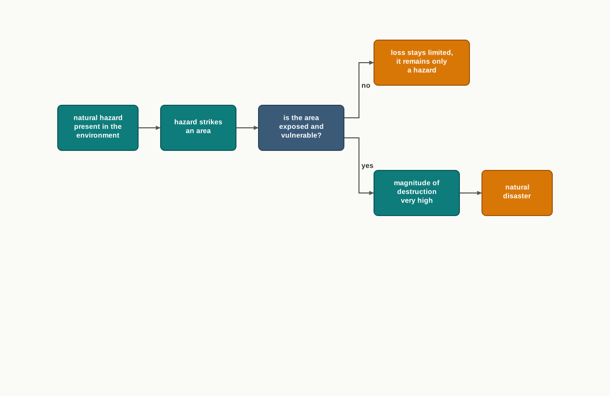
Fig. 6.1 – When a hazard becomes a disaster.
No two disasters are exactly alike. Every disaster is shaped by the local socio-environmental conditions that control it, the response it draws out, and the way each social group negotiates with it. Even so, looking across many disasters tells us three things. First, the magnitude, intensity, frequency and damage of natural disasters have increased over the years. Second, there is growing concern worldwide to cut the resulting loss of life and property. Third, the very pattern of natural disasters has changed over time.
Why Losses Keep Rising
The way people see hazards and disasters has itself shifted. Once, hazard and disaster were treated as tightly linked: an area exposed to a hazard was seen as bound to suffer a disaster. So people left the delicate balance of a given ecosystem alone. They avoided crowding their activities into such areas, and that is precisely why disasters did less damage then.
Technological power changed that restraint. It gave human beings a large capacity to intervene in nature, and now people tend to push their activities into disaster-prone areas rather than avoid them. Vulnerability — how exposed a community is and how poorly it can cope when a hazard strikes — climbs as a result.
The clearest case is land. People have colonised the flood plains of most rivers. Large cities and port-towns such as Mumbai and Chennai have spread right along the coast and up to the shoreline, because coastal land carries high value. That very choice sets them squarely in the path of cyclones, hurricanes and tsunamis.
A Global Response
Natural disasters have caused widespread loss of life and property, and efforts to deal with them are on at various levels. Their damage now reaches beyond the means and capabilities of any single nation-state — it has become a global problem. The United Nations General Assembly took up this concern in 1989. It was finally formalised in May 1994 at the World Conference on Disaster Management in Yokohama, Japan, and the outcome was named the Yokohama Strategy and Plan of Action for a Safer World.
At Yokohama, all the member states of the United Nations and other states met from 23 to 27 May 1994. They acknowledged that the human and economic losses from natural disasters had risen in recent years, and that society in general had become more vulnerable to them. They accepted, too, that these disasters hurt the poor and disadvantaged groups worst, especially in the developing countries least equipped to cope. The conference adopted the Yokohama strategy as a guide for the rest of the decade and beyond.
Its resolution set out four commitments. First, each country holds the sovereign responsibility to protect its own citizens from natural disasters. Second, priority attention goes to the developing countries, particularly the least-developed, land-locked, and small-island developing states. Third, nations will develop and strengthen national capacities and, where appropriate, national laws for disaster prevention, mitigation and preparedness — drawing in non-governmental organisations and local communities. Fourth, they will promote and strengthen cooperation across sub-regions, regions and the world, with emphasis on capacity-building, on technology sharing (the collection, spread and use of information), and on the mobilisation of resources. The conference also declared the decade 1990–2000 the International Decade for Natural Disaster Reduction (IDNDR).
6.2 Classification Of Natural Disasters
People the world over have always experienced disasters, faced them, and lived with them. What is new is awareness. Steps are now being taken at many levels to reduce the effects of disasters, and identifying and classifying them is treated as an effective, scientific first step — because you cannot deal promptly and efficiently with something you have not first sorted out.
Broadly, natural disasters fall into four categories. Each is named for the sphere of the environment the hazard rises from: the atmosphere, the solid earth, water, and the living world.
The full classification is set out in Table 6.1.
Reading down the columns shows how very different hazards can share a common origin. Atmospheric hazards — from blizzards and thunderstorms to drought, the heat wave known as the loo, and cold waves — all begin in the air. Terrestrial hazards such as earthquakes, volcanic eruptions, landslides and soil erosion arise from the solid earth. Aquatic hazards — floods, tidal waves, storm surge and tsunami — come from water. Biological hazards include plants and animals acting as colonisers, such as locusts, and infestations and diseases such as bird flu and dengue.
India sits among the countries that have experienced most of the disasters in this list. Every year it loses thousands of lives, and property worth millions of rupees, to these natural calamities. The sections that follow take up the most devastating of them, one by one, in the Indian context.
6.3 Natural Disasters And Hazards In India
India is vast and diverse, both in its physical make-up and in its society and culture, as earlier chapters have discussed. Its huge geographical area, its range of environments, and its cultural plurality are why it is so often called the ‘Indian-subcontinent’ and the ‘land of unity in diversity’.
That same vastness, however, works against it when hazards strike. A large natural range, a prolonged colonial past, continuing forms of social discrimination, and a very large population together raise India’s vulnerability — its exposure and its limited capacity to cope — when disaster comes. The major natural disasters of India, taken up one by one below, show this clearly.
6.3.1 Earthquakes
Earthquakes are by far the most unpredictable and the most destructive of all natural disasters. You have already met their causes in the book Fundamentals of Physical Geography (NCERT, 2024); here the concern is what they do to India.
Earthquakes of tectonic origin — those driven by the movement of the great plates that make up the Earth’s crust — are the most devastating, and their area of influence is large. They result from a series of earth movements set off by a sudden release of energy during tectonic activity in the crust. By comparison, earthquakes tied to volcanic eruptions, rock falls, landslides, subsidence in mining areas, or the impounding of dams and reservoirs affect a much smaller area and do less damage.
The Tectonic Setting
Chapter 2 of this book noted that the Indian plate is drifting north and north-east at about one centimetre a year — roughly the pace at which a fingernail grows. From the north, the Eurasian plate blocks its path. The two plates lock against each other, and energy accumulates at points along the boundary at different times.
When this stored energy grows too great, stress builds until the lock breaks. The sudden release of that energy is felt as an earthquake along the Himalayan arch. This is the mechanism behind the great earthquakes of the mountain belt (Fig. 6.2).
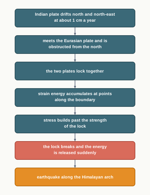
Fig. 6.2 – Tectonic mechanism of Himalayan earthquakes.
Because of this, the most vulnerable states and union territories are Jammu and Kashmir, Ladakh, Himachal Pradesh, Uttarakhand, Sikkim, the Darjeeling subdivision of West Bengal, and all seven states of the north-east.
Away from the mountains, the central-western parts of India have also felt severe earthquakes — Gujarat in 1819, 1956 and 2001, and Maharashtra in 1967 and 1993. Earth scientists long found it hard to explain quakes in the Peninsular block, one of the oldest, most stable and mature landmasses on Earth. Recently, some have proposed a fault line with energy building along it, marked by the river Bhima (Krishna) near Latur and Osmanabad in Maharashtra, and a possible breaking down of the Indian plate (Fig. 6.3).
India’s Earthquake Zones
The National Geophysical Laboratory, the Geological Survey of India, the Department of Meteorology of the Government of India, together with the recently formed National Institute of Disaster Management, studied more than 1,200 earthquakes recorded in India over the years. On that evidence they divided the country into five earthquake zones: a very high damage risk zone, a high damage risk zone, a moderate damage risk zone, a low damage risk zone, and a very low damage risk zone.
The first two zones have seen the most devastating quakes. As Fig. 6.3 shows, the Very High Damage Risk Zone covers the north-east states; the areas north of Darbhanga and Araria along the Indo-Nepal border in Bihar; Uttarakhand; western Himachal Pradesh around Dharamshala; the Kashmir Valley in the Himalayan region; and Kuchchh in western Gujarat.
The High Damage Risk Zone takes in the remaining parts of Kashmir, Ladakh and Himachal Pradesh, the northern parts of Punjab, the eastern parts of Haryana, Delhi, western Uttar Pradesh, and northern Bihar. The rest of the country falls under moderate to very low risk. The safest ground of all is the stable landmass beneath the Deccan plateau.
Map
Fig. 6.3 Caption: India: earthquake hazard zones. Brief: thematic map of India showing five damage-risk zones keyed to the MSK intensity scale — very high (MSK IX), high (MSK VIII), moderate (MSK VII), low (MSK VI), very low (MSK V); shade the Himalaya, the north-east and Kachchh as highest risk and the Deccan as lowest; show the full extent of India as officially defined; key to list the five zones with their MSK values.
6.3.1.1 Socio-Environmental Consequences Of Earthquakes
An earthquake carries fear and horror because of the scale, the magnitude and the suddenness with which it spreads destruction across the surface, striking without discrimination. It turns into a calamity when it hits an area of high population density.
It does not only destroy settlements, infrastructure, the transport and communication network, industries and other developmental works. It also robs people of the material and cultural gains built up over generations, and leaves them homeless. That loss falls hardest, and lasts longest, on the weak economies of the developing countries.
6.3.1.2 Effects Of Earthquakes
The effects of an earthquake reach across the whole area it strikes. The most important of them are set out in Table 6.2, grouped by what they act upon — the ground, structures built by people, and water.
One effect on the ground deserves a plain word. Liquefaction is when shaking turns water-logged, loose soil to behave like a liquid, so that the solid buildings standing on it sink or tilt. Another is the opening of fissures, and these matter beyond the moment of the quake.
Earthquakes also have serious, far-reaching environmental consequences. Surface seismic waves crack open fissures in the upper layers of the crust, through which water and other volatile materials gush out and flood the neighbouring land. Earthquakes also set off landslides, and these often block the flow of rivers and channels, ponding the water back into new reservoirs. Sometimes a river even shifts its course, bringing floods and other calamities to the affected area.
6.3.1.3 Earthquake Hazard Mitigation
The damage from earthquakes is more devastating than from most disasters, and because a quake wrecks transport and communication links as well, getting timely relief to victims is hard. Since the occurrence of an earthquake cannot be prevented, the next best option is to stress preparedness and mitigation rather than cure.
Four measures stand out. First, set up earthquake monitoring centres — seismological centres — for steady watching and fast sharing of information among people in the vulnerable areas; the Geographical Positioning System (GPS) can help track the movement of the tectonic plates. Second, prepare a vulnerability map of the country, spread the risk information, and teach people how to reduce the harm. Third, modify house types and building designs in vulnerable areas, and discourage high-rise buildings, large industrial establishments and big urban centres there. Fourth, make it mandatory to use earthquake-resistant designs and light materials in major construction in those areas.
6.3.2 Tsunami
When an earthquake or a volcanic eruption makes the sea floor move abruptly, it shoves the ocean water above it upward in the form of high vertical waves. These are tsunamis — ‘harbour waves’, also called seismic sea waves. A single seismic jolt usually raises just one instantaneous vertical wave; but after that first disturbance, a train of afterwaves is set up, rocking between high crest and low trough as the sea works to restore its level.
How the wave behaves depends on the depth of the water beneath it, and this is why a tsunami is barely felt over the deep ocean yet devastating at the coast. Over deep water the wave is very long but low; a ship at sea is lifted only a metre or two, and each slow rise and fall takes several minutes, so the tsunami is hard even to detect out there. As the wave runs into shallow water near the shore, its wave-length shortens while its period stays the same, and all that energy stacks up into height. The wave can rear to 15 m or more and smash the shore, which is why tsunamis are also called shallow water waves.
Tsunamis are seen most often along the Pacific ring of fire — the coasts of Alaska, Japan, the Philippines and other islands of South-east Asia, along with Indonesia, Malaysia, Myanmar, Sri Lanka and India. Reaching the coast, the waves unleash the enormous energy stored in them, and the water pours turbulently over the land, destroying port-cities, towns, buildings and settlements. Because coasts are densely populated and full of human activity, a tsunami tends to kill and destroy far more there than other coastal hazards do. The scale of that devastation can be studied through the visuals on Banda Ache in Indonesia, presented in Practical Work in Geography — Part I (NCERT, 2025).
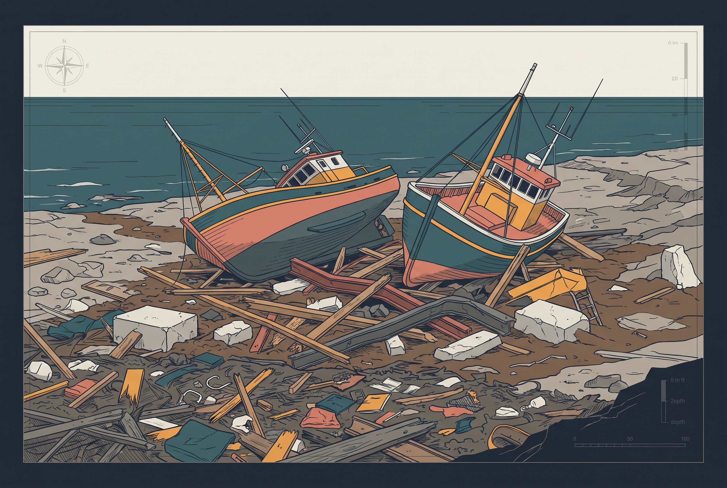
Fig. 6.4 – Tsunami devastation on the coast.
Reducing tsunami losses is especially hard, because the damage is on such a large scale — beyond the capacity of any single state or government to handle. So the way forward is combined effort at the international level. This was the case with the tsunami of 26 December 2004, in which more than 300,000 people lost their lives; after it, India volunteered to join the International Tsunami Warning System.
6.3.3 Tropical Cyclone
A tropical cyclone is an intense low-pressure area, confined to the belt between 30° N and 30° S, with high-velocity winds whirling around it. It spreads 500–1,000 km across and reaches from the surface up to 12–14 km high. A tropical cyclone — a hurricane, by another name — works like a heat engine. Its fuel is latent heat, the heat set free when water vapour, gathered by the wind as it crosses warm oceans and seas, condenses back into cloud (Fig. 6.5).
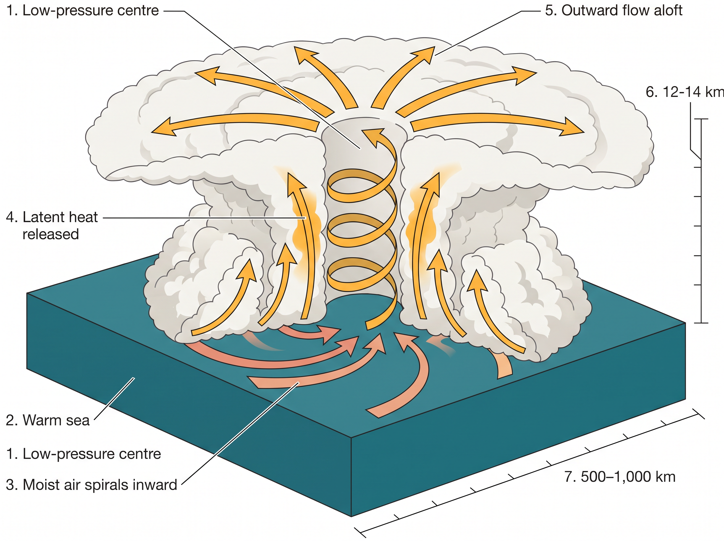
Fig. 6.5 – Tropical cyclone structure and heat engine mechanism.
Scientists differ on the exact mechanism, but they agree on some initial conditions a tropical cyclone needs. It requires a large, continuous supply of warm, moist air able to release enormous latent heat. It needs a strong Coriolis force — the deflecting effect of the Earth’s rotation on moving air — to keep the central low pressure from filling in; near the equator this force is absent, which is why cyclones do not form between 0° and 5° latitude. It also needs unstable air through the troposphere to stir up the local disturbances a cyclone can grow around, and an absence of a strong vertical wind wedge, which would otherwise break up the upward transport of latent heat.
6.3.3.1 Spatio-Temporal Distribution Of Tropical Cyclone In India
India’s peninsular shape puts water on two sides — the Bay of Bengal in the east and the Arabian Sea in the west — and its cyclones are born in both. Most originate between 10° and 15° N during the monsoon season. In the Bay of Bengal, though, cyclones mostly develop in October and November, forming in the belt from about 16° N northward and to the west of 92° E. By July, the place of origin shifts to around 18° N and west of 90° E, near the Sunderban delta at the head of the bay.
Map
Fig. 6.6 Caption: India: wind and cyclone hazard zones. Brief: thematic map of India showing wind-and-cyclone damage-risk zones with design wind speeds — very high risk A (55 m/s) and B (50 m/s), high (47 m/s), moderate A (44 m/s) and B (39 m/s), low (34 m/s); shade the east coast, the north-east and the north-west as highest risk; show the full extent of India as officially defined; key to list each zone with its wind speed.
6.3.3.2 Consequences Of Tropical Cyclones
Since a cyclone’s energy comes from the latent heat of warm, moist sea air, its force weakens as it moves away from the sea. In India, the force fades with distance inland from the Bay of Bengal and the Arabian Sea. So it is the coasts that are struck by severe cyclonic storms, with winds averaging 180 km/h. These often drive an abnormal rise in sea level called a storm surge.
A surge is born from the meeting of air, sea and land. The cyclone supplies the driving force in the shape of a very high horizontal pressure gradient and very strong surface winds. The sea water is pushed across the coast together with the winds and heavy downpour, flooding human settlements and farm fields, ruining crops and wrecking the structures people have built.
6.3.4 Floods
Flooding is the inundation of land and settlements when water rises in the channels and spills over. Unlike most disasters, the causes of floods are well understood; floods come relatively slowly, in well-identified regions, and within an expected part of the year.
A flood most commonly occurs when the surface run-off exceeds the carrying capacity of the river channels and streams, so the water flows out into the neighbouring low-lying flood plains — and at times overwhelms even the lakes and inland water bodies it drains into. Floods can also be set off by a storm surge on the coast, by high-intensity rainfall over a long spell, by melting ice and snow, by a fall in the infiltration rate, and by eroded material choking the water where soil erosion runs high. Though floods strike over wide areas the world over, they are frequent and severe in the South, South-east and East Asian countries — China, India and Bangladesh.
Here too, human beings shape the disaster. Indiscriminate deforestation, unscientific farming, meddling with the natural drainage channels, and the colonisation of flood-plains and river-beds all raise the intensity, magnitude and gravity of floods.
Where Floods Strike
The Rashtriya Barh Ayog — the National Flood Commission — identified 40 million hectares of land as flood-prone in India. Fig. 6.7 maps these flood-affected areas. Assam, West Bengal and Bihar rank among the most flood-prone states. Most rivers of the northern states, such as Punjab and Uttar Pradesh, are also open to occasional floods.
In recent decades, states like Rajasthan, Gujarat, Haryana and Punjab have begun to see flash floods too — partly from the behaviour of the monsoon, and partly from the blocking of streams and channels by human activity. Tamil Nadu, on the far south-east, sometimes floods in November–January, from the retreating monsoon rather than the summer one.
Map
Fig. 6.7 Caption: India: flood hazard zones. Brief: thematic map of India with the major rivers labelled and the areas liable to flood shaded along their courses, concentrated in the Ganga and Brahmaputra plains and the deltas; show the full extent of India as officially defined; key to mark ‘area liable to flood’.
6.3.4.1 Consequence And Control Of Floods
Repeated flooding of farmland and settlements has grave costs for the national economy and society. The worst-hit are the flooding-river belts of Assam, West Bengal, Bihar and eastern Uttar Pradesh; the cyclone-struck coasts of Odisha, Andhra Pradesh, Tamil Nadu and Gujarat; and the flash-flood tracts of Punjab, Rajasthan, northern Gujarat and Haryana.
Floods do not only destroy crops year after year. They also break roads, railways, bridges and settlements, render millions homeless, and sweep people away along with their cattle. In their wake spread cholera, gastro-enteritis, hepatitis and other water-borne diseases.
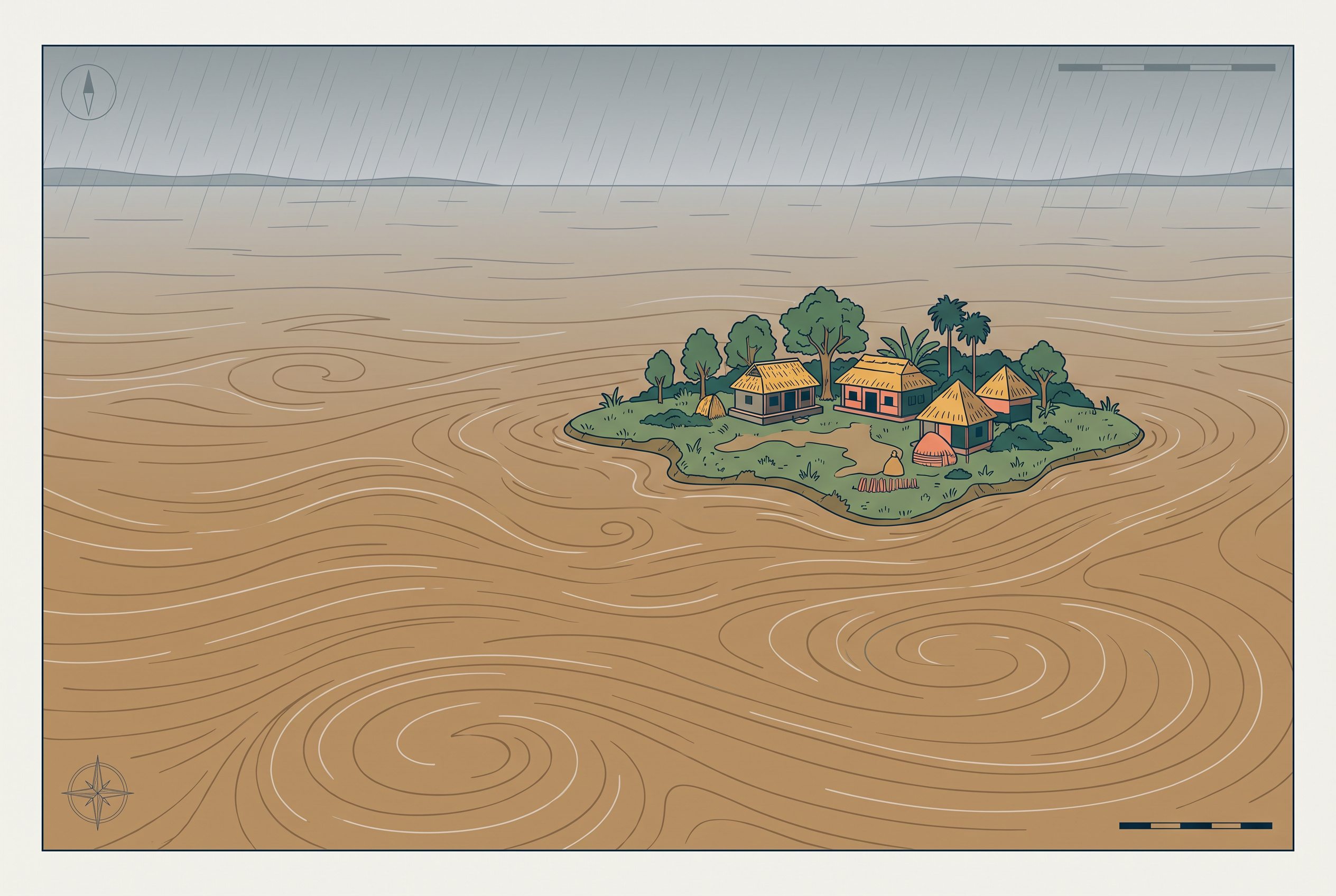
Fig. 6.8 – The Brahmaputra river in severe flood.
Yet floods also do a little good. Each year they lay down fertile silt over the fields, which is good for crops.
The lesson of Majuli is not that floods are a blessing. The chapter is plain that these gains are insignificant beside the grave losses floods bring. The same flood that renews the soil is the one that drowns homes and cattle downstream; whether it reads as blessing or disaster turns on its scale, its timing, and what stands in its path.
The Government of India and the state governments are well aware of this yearly menace. Their response includes building flood-protection embankments in flood-prone areas, constructing dams, planting forests, and discouraging major construction in the upper reaches of flood-creating rivers — steps needed urgently. Removing human encroachment from river channels and depopulating the flood plains are further steps, especially in the western and northern tracts that face flash-floods. On coasts hit by a storm surge, cyclone centres can provide relief.
6.3.5 Droughts
The word ‘drought’ is used for an extended period when water runs short — because precipitation is inadequate, evaporation is excessive, and water is over-drawn from reservoirs and other storages, including the ground water.
Drought is a complex phenomenon. It draws in many elements of meteorology — precipitation, evaporation, evapo-transpiration, ground water, soil moisture, storage and surface run-off — as well as agricultural practices (particularly the types of crops grown), socio-economic practices and ecological conditions.
6.3.5.1 Types Of Droughts
Geographers distinguish four kinds of drought, and the difference lies in what is running short. A meteorological drought is a prolonged spell of inadequate rainfall, badly distributed in time and space — it is a shortfall in the rain itself. An agricultural drought, also called soil-moisture drought, is when soil moisture drops too low to support the crops, so harvests fail; an area with more than 30 per cent of its gross cropped area under irrigation is kept out of the drought-prone category, because irrigation makes up for the missing rain. A hydrological drought is when the water in storages and reservoirs — aquifers, lakes, reservoirs — falls below what precipitation can replenish. An ecological drought is when a natural ecosystem loses its productivity from lack of water, and the ecological distress damages the ecosystem itself. Various parts of India meet these droughts again and again, with serious socio-economic and ecological costs.
6.3.5.2 Drought Prone Areas In India
Indian agriculture leans heavily on the monsoon rains, and drought and flood are the two companion features of India’s climate. By some estimates, nearly 19 per cent of the country’s total geographical area and 12 per cent of its population suffer from drought every year, and about 30 per cent of the total area is identified as drought-prone, affecting around 50 million people.
It is a common sight for one part of the country to reel under floods while another faces severe drought in the same period — and for a single region to flood in one season and go dry in the next. The reason is the large-scale variation and unpredictability of the Indian monsoon. So droughts are widespread across the country, but most recurrent and severe in some parts and mild in others.
On the basis of severity, India can be divided into three drought regions. The Extreme Drought Affected Areas, evident from Fig. 6.9, cover most of Rajasthan west of the Aravali hills — the Marusthali desert and the Kachchh region of Gujarat — including desert districts like Jaisalmer and Barmer, which receive less than 90 mm of average annual rainfall. The Severe Drought Prone Areas take in parts of eastern Rajasthan, most of Madhya Pradesh, eastern Maharashtra, interior Andhra Pradesh and the Karnataka plateau, northern parts of interior Tamil Nadu, and southern Jharkhand with interior Odisha. The Moderate Drought Affected Areas include northern Rajasthan, Haryana, the southern districts of Uttar Pradesh, the rest of Gujarat, Maharashtra except the Konkan, Jharkhand, the Coimbatore plateau of Tamil Nadu, and interior Karnataka. The remaining parts of India are either drought-free or only slightly prone.
Map
Fig. 6.9 Caption: India: drought-prone areas. Brief: thematic map of India ranking drought severity in three zones — extreme, severe and moderate — with a fourth class for drought-free areas; shade the desert west of the Aravali as extreme; show the full extent of India as officially defined; key to list the three drought zones and the drought-free class.
6.3.5.3 Consequences Of Drought
Drought sets off a cascade of effects on both the environment and society. Crop failure brings a scarcity of food grains, called akal; there is also a shortage of fodder, called trinkal, and a shortage of water, called jalkal. When all three fall short together — trikal — the drought is most devastating of all. Cattle and other animals die in large numbers, and people and livestock migrate. Short of water, people are forced to drink from contaminated sources, and water-borne diseases such as gastro-enteritis, cholera and hepatitis spread.
Because drought has both immediate and long-term effects, planning must address both. In the immediate term, safe drinking water, medicines, and fodder and water for cattle must reach the victims, and people and livestock may need shifting to safer places. For the longer term, ground water potential in aquifers has to be identified, river water transferred from surplus to deficit areas, and the inter-linking of rivers along with reservoirs and dams seriously considered. Remote sensing and satellite imagery can help pick out the river-basins that could be inter-linked and locate the ground water.
Spreading knowledge of drought-resistant crops, and training farmers to grow them, are useful long-term measures. So is rainwater harvesting, which can do much to soften a drought. It is worth observing the roof-top rainwater harvesting already practised in your own locality, and asking how it could be made more effective.
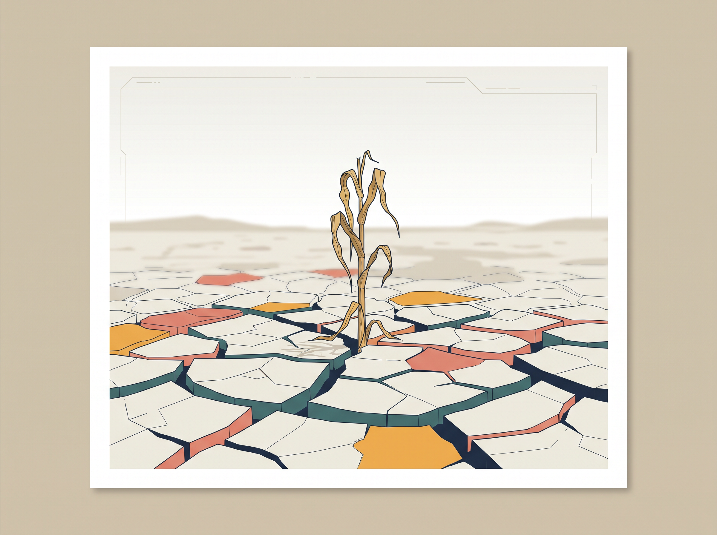
Fig. 6.10 – Parched and deeply cracked ground during a drought.
6.3.6 Landslides
Have you read of roads to Srinagar being blocked, or rail services along the Konkan Railway on the western coast disrupted by falling stones? Both happen because of a landslide — the rapid sliding of a large mass of bedrock down a slope. Landslides are far less dramatic than earthquakes, volcanic eruptions, tsunamis or cyclones, but their toll on the natural environment and the national economy is in no way lighter.
What makes them different is scale of control. Most disasters are sudden, unpredictable and governed by macro or regional forces; landslides are governed by highly localised factors. That makes gathering information and monitoring them not only difficult but very costly. It is hard to define or generalise a landslide precisely. Even so, from past experience, from frequency, and from the causal links with controlling factors — geology, geomorphic agents, slope, land use, vegetation cover and human activity — India has been divided into a number of zones.
6.3.6.1 Landslide Vulnerability Zones
The Very High Vulnerability Zone covers the highly unstable, relatively young mountains of the Himalayas and of the Andaman and Nicobar Islands; the high-rainfall, steep-sloped stretches of the Western Ghats and the Nilgiris in the south; the north-eastern regions; areas that shake often from earthquakes; and areas of intense human activity, especially the building of roads and dams.
The High Vulnerability Zone has almost the same conditions as the very high one; the difference lies only in the mix, intensity and frequency of the controlling factors. It includes all the Himalayan states and the north-eastern regions, except the plains of Assam.
The Moderate to Low Vulnerability Zone takes in the low-rainfall tracts — the Trans-Himalayan areas of Ladakh and Spiti in Himachal Pradesh, the undulating but stable low-rainfall country of the Aravali, and the rain-shadow areas of the Western and Eastern Ghats and the Deccan plateau. Landslides from mining and subsidence are most common here, in states like Jharkhand, Odisha, Chhattisgarh, Madhya Pradesh, Maharashtra, Andhra Pradesh, Karnataka, Tamil Nadu, Goa and Kerala.
The remaining parts of India — Rajasthan, Haryana, Uttar Pradesh, Bihar, West Bengal (except Darjiling district), Assam (except Karbi Anglong district) and the coastal regions of the southern states — are safe as far as landslides go.
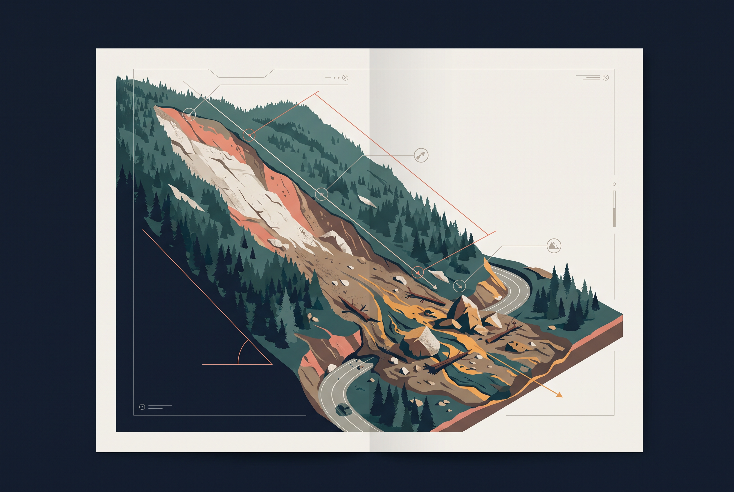
Fig. 6.11 – A mountain slope scarred by a landslide.
6.3.6.2 Consequences Of Landslides
A landslide has a small, localised area of direct effect, yet its reach is long. Roadblocks, broken railway lines, and channels blocked by rock-falls carry far. When a landslide diverts a river’s course, it can bring flooding and loss of life and property. It also makes movement across space difficult, risky and costly, which in turn holds back development in the affected areas.
6.3.6.3 Mitigation
The wise course with landslides is area-specific. Restrict construction and developmental works such as roads and dams; limit farming to valleys and gentle slopes; and control the growth of large settlements in the high-vulnerability zones. Back this with positive action — large-scale afforestation, and the building of bunds to slow the flow of water. In the north-eastern hill states, where Jhumming (slash-and-burn, or shifting, cultivation) is still practised, terrace farming should be encouraged in its place.
6.4 Disaster Management
Not every disaster is equally beyond reach. Disasters from cyclones, unlike those from earthquakes, tsunamis and volcanic eruptions, are more predictable in both the time and the place of their striking. As techniques to monitor a cyclone’s behaviour, intensity, direction and magnitude have improved, it has become possible to manage the cyclonic hazard to some extent.
Several steps help cut the damage: building cyclone-shelters, embankments, dykes and reservoirs, and planting forests to slow the winds. Yet the loss of life and property keeps rising in successive storms in countries like India, Bangladesh and Myanmar. The reason is not that the storms have grown stronger; it is that the coastal populations in their path are so highly vulnerable.
Behind these efforts stands a legal framework that says, in plain terms, what counts as a disaster and when a community can no longer manage on its own.
6.5 Conclusion
The chapter’s discussion leads to a clear conclusion. Disasters can be natural or the result of human activity, and not every hazard has to turn into a disaster. Since disasters — natural ones above all — are so difficult to eliminate, the next best option is mitigation and preparedness.
Disaster mitigation and management run in three stages, and together they form a cycle (Fig. 6.12). Before a disaster, in pre-disaster management, the work is to generate data and information about disasters, prepare vulnerability zoning maps, and spread awareness — along with disaster planning, preparedness and preventive measures in the vulnerable areas. During a disaster, rescue and relief must move on an emergency footing: evacuation, the building of shelters and relief camps, and the supply of water, food, clothing and medical aid. After a disaster, in post-disaster operations, the task is the rehabilitation and recovery of victims, and capacity-building so the community can cope with any future disaster.
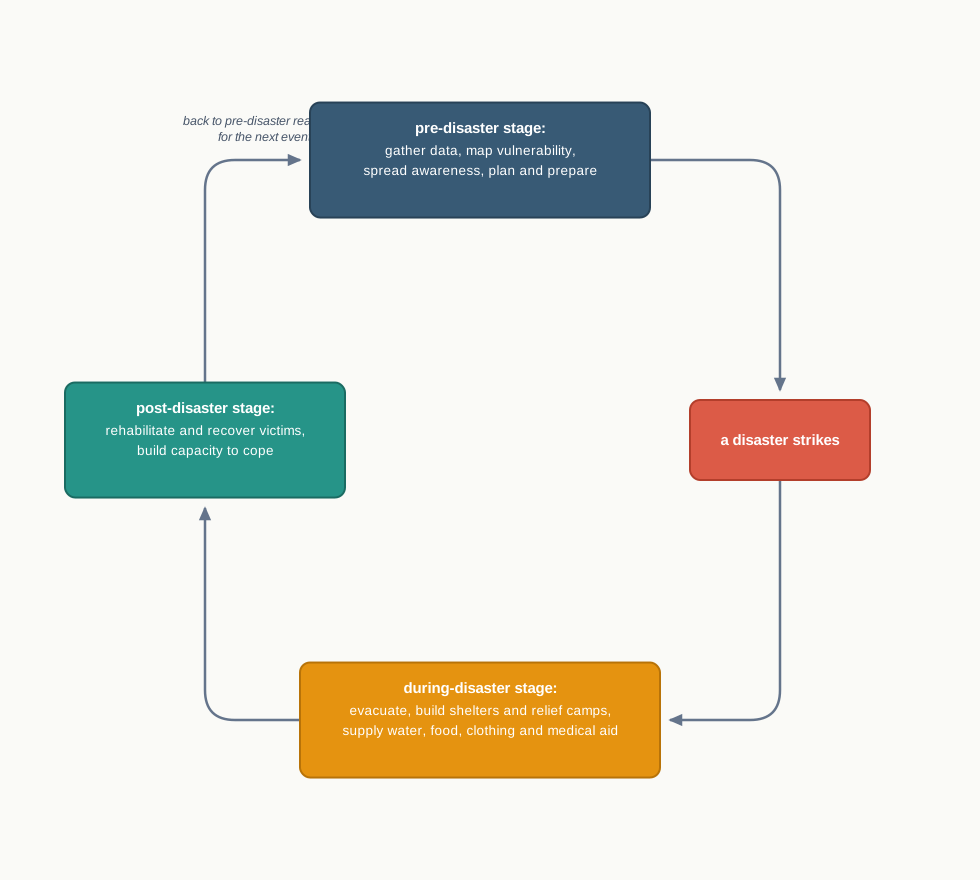
Fig. 6.12 – The disaster management cycle.
These measures matter especially for India, where about two-thirds of the geographical area, and a similar share of the population, are vulnerable to disasters. Two positive steps by the Government of India stand out: the introduction of the Disaster Management Bill, 2005, and the establishment of the National Institute of Disaster Management.
The Bill gives disaster a broad legal meaning. It defines a disaster as a catastrophe, mishap, calamity or grave occurrence in any area — arising from natural or man-made causes, or from accident or negligence — that brings substantial loss of life or human suffering, or damages and destroys the environment, and is of such nature or magnitude that it lies beyond the coping capacity of the community of the affected area.
6.6 Summary
- Change is constant. From nature’s side it is value-neutral; from the human side it is value-loaded. The changes we fear and study in this chapter are disasters.
- A hazard is a threat sitting in the environment; a disaster is what happens when that threat strikes on a large scale and the magnitude of destruction is very high.
- A hazard becomes a disaster mainly where people and property are exposed and least able to cope — vulnerability, not the hazard alone, decides the loss.
- Disasters can be natural or human-made — directly, as in the Bhopal Gas tragedy or Chernobyl, or indirectly, as in landslides and floods from deforestation.
- Human-made disasters can be partly prevented; natural disasters mostly cannot, so the effort turns to mitigation and management.
- International action matters: the Yokohama Strategy and Plan of Action for a Safer World (1994) and the International Decade for Natural Disaster Reduction (1990–2000).
- Natural disasters fall into four categories by origin — atmospheric, terrestrial, aquatic and biological.
- India’s vast area, its colonial past, continuing social discrimination and large population together raise its vulnerability to disasters.
- Tectonic earthquakes are the most destructive. The Indian plate pushing into the Eurasian plate stores and then releases energy along the Himalayan arch; India is divided into five earthquake risk zones, and the Deccan is safest.
- A tsunami begins when a quake or eruption shifts the sea floor and displaces the water. The wave is low over the deep sea and rears at the coast, up to 15 m; the tsunami of 26 December 2004 killed more than 300,000 people.
- A tropical cyclone is a heat engine fed by latent heat. It needs warm, moist air, a strong Coriolis force, and an unstable troposphere; India’s coasts on the Bay of Bengal and the Arabian Sea are struck, and a storm surge raises the sea across the coast.
- Floods occur when run-off exceeds a channel’s capacity. They come in known regions and seasons, are worsened by human activity, and hit Assam, West Bengal and Bihar hardest — though they also lay down fertile silt, as on Majuli.
- Droughts are extended shortages of water, of four kinds — meteorological, agricultural, hydrological and ecological. The monsoon’s variability drives both flood and drought, and India is zoned into extreme, severe and moderate drought areas.
- Landslides are the rapid sliding of bedrock, governed by highly localised factors; the Himalayas, the north-east and the Western Ghats are most vulnerable, and mitigation must be area-specific.
- Cyclones are more predictable, and so more manageable, than earthquakes or tsunamis; yet crowded, vulnerable coasts keep the losses high.
- Disaster management runs in three stages — pre-disaster, during-disaster and post-disaster. The Disaster Management Bill, 2005 and the National Institute of Disaster Management are India’s steps in this direction.
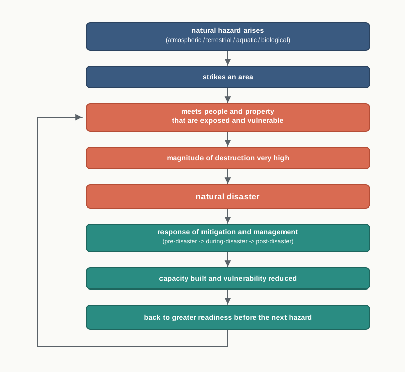
Fig. 6.13 – Summary of hazard, disaster, and management.
What This Chapter Cannot Tell You
The hazard-zone maps show where risk is high, not when the next earthquake, cyclone, flood or drought will come, or how strong it will be.
National shares — the roughly 30 per cent of the country called drought-prone, the 40 million hectares called flood-prone — average across districts and villages, and hide who inside a zone is actually exposed and who is safe.
The chapter maps hazards and vulnerability, but it cannot tell the human story of any single disaster: who was lost, who recovered, and why two places struck by the same storm fared so differently.
6.7 NCERT Questions
Which one of the following states of India experiences floods frequently?
- Bihar
- West Bengal
- Assam
- Uttar Pradesh
In which one of the following districts of Uttaranchal did the Malpa Landslide disaster take place?
- Bageshwar
- Champawat
- Almora
- Pithoragarh
Which one of the following states receives floods in the winter months?
- Assam
- West Bengal
- Kerala
- Tamil Nadu
In which of the following rivers is the Majuli River Island situated?
- Ganga
- Brahmaputra
- Godavari
- Indus
Under which type of natural hazards do blizzards come?
- Atmospheric
- Aquatic
- Terrestrial
- Biological
When can a hazard become a disaster? (less than 30 words)
Why are there more earthquakes in the Himalayas and in the north-eastern region of India? (less than 30 words)
What are the basic requirements for the formation of a cyclone? (less than 30 words)
How are the floods in Eastern India different from the ones in Western India? (less than 30 words)
Why are there more droughts in Central and Western India? (less than 30 words)
Identify the landslide-prone regions of India and suggest some measures to mitigate the disasters caused by these. (not more than 125 words)
What is vulnerability? Divide India into natural disaster vulnerability zones based on droughts and suggest some mitigation measures. (not more than 125 words)
When can developmental activities become the cause of disasters? (not more than 125 words)
6.8 Check Your Concepts
Table 6.1 sorts natural disasters into four groups. On what basis are the groups defined, and to which group does a tsunami belong?
Look at Fig. 6.3. On what intensity scale are the five earthquake zones graded, and in which damage-risk zone does the Deccan plateau fall?
Explain why a tsunami raises a ship at sea by only a metre or two, yet rears into a wall of water metres high at the coast.
Distinguish between a meteorological drought and an agricultural drought, and state why an area with more than 30 per cent of its gross cropped area under irrigation is left out of the drought-prone category.
What is a storm surge, and how does a tropical cyclone generate it?
Arrange in order the steps by which the movement of the Indian plate produces an earthquake along the Himalayan arch.
A tropical cyclone extends 500–1,000 km across but only 12–14 km high. What does this contrast tell you about the shape of the storm, and why does its force weaken as it moves inland from the sea?
The drought-prone areas map (Fig. 6.9) ranks each region by the severity of drought it faces. State one thing this map cannot tell you about a drought in any of those regions.