Chapter 3: Drainage System
Every monsoon, as the rains break over the eastern Himalayas, a river in northern Bihar begins to fill. The Kosi has carried the same cargo for as long as anyone has kept a record — sand, silt and gravel, ground off the young mountains upstream and swept down onto the plains. Where the land flattens and the water slows, the river can no longer hold that load. It drops it, layer on layer, on its own bed.
Slowly the bed rises. The river ends up running higher than the fields beside it, held in only by the banks it has built for itself. Then one heavy season the channel chokes, the water finds a lower path, and the whole river swings sideways — sometimes by many kilometres — leaving dry the towns that stood on its bank and drowning villages that never expected it. Bihar has a name for this river. It calls the Kosi its sorrow.
A river, then, is not a fixed line on a map. It is a working machine that moves water and rock from high ground to the sea, and rebuilds the land as it goes. Where its channel is clear, it drains the excess water and the plain stays dry. Where the channel is choked or ill-defined, the water spreads and floods. This chapter is about that machinery — where India’s rivers rise, where they go, and why they behave as they do.
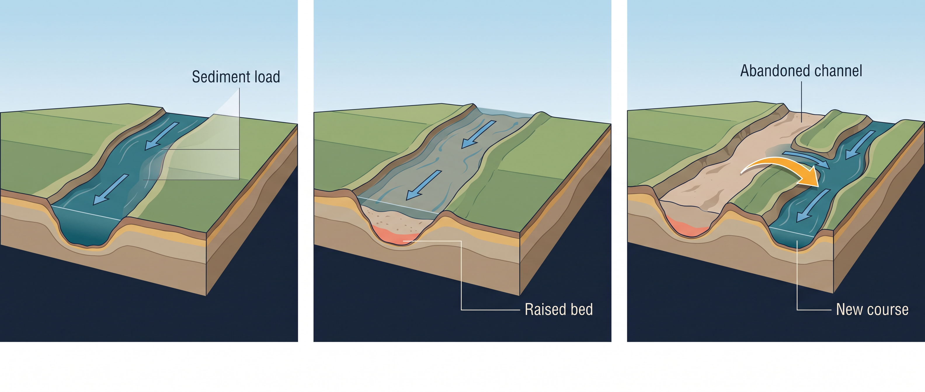
Fig. 3.0 – River channel choking and course shift.
3.1 Drainage, Basins And Watersheds
You have watched water run off the land during the rains — down rivers, down nalas (the local word for the small streams and channels that carry water away), and down cuts made to drain the excess. Had those channels not been there, the water would have spread across the land and flooded it. Wherever a channel is ill-defined or choked, flooding is exactly what follows.
Drainage is the flow of water through well-defined channels, and the whole network of such channels together is a drainage system. The pattern a drainage system settles into is not accidental. It is the outcome of the long geological time over which it formed, the nature and structure of the rocks beneath it, the topography and slope of the land, the amount of water moving through it, and whether that flow is steady or seasonal.
A river you know may run all year or only in the wet months. A perennial river always has water; an ephemeral river carries water in the rainy season and lies dry the rest of the year. Water moves the way it does because of slope — it runs downhill, from higher ground to lower. That is the plain reason the rivers rising in the Himalayas in the north and in the Western Ghats in the south run eastward and empty into the Bay of Bengal: the land, taken as a whole, slopes that way. A river in its steep mountain course is shown in Fig. 3.1.
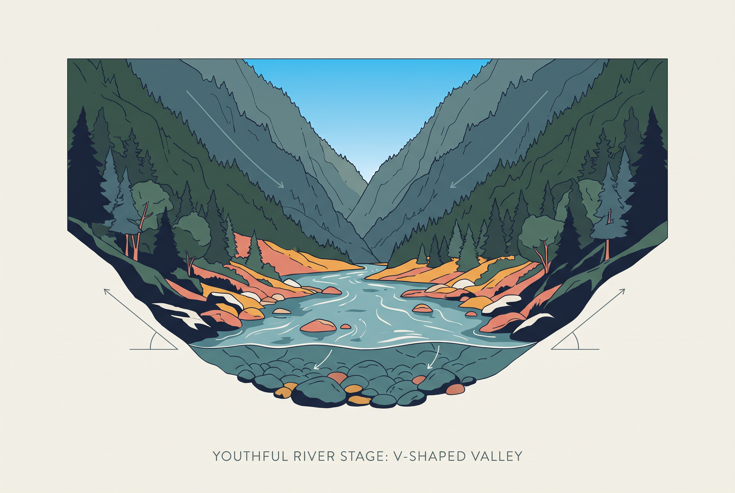
Fig. 3.1 – A river in its mountainous upper course.
What A River Drains
A river collects its water from a particular stretch of land, and that stretch is its catchment area. The full area drained by a river together with its tributaries — the smaller streams that feed into it — is a drainage basin.
The line of high ground that separates one basin from the next is the watershed: rain falling on one side of it runs to one river, rain on the other side runs to another. The word is also used in a second, narrower sense — for the small catchment of a rivulet or a rill, as against the river basin of a large river. The difference here is only one of size. A watershed, in that sense, is small; a river basin covers a far larger area.
Whichever the scale, a basin acts as a single unit. What happens in one part of it is felt in the rest, because water carries the effect downstream. This is why basins and watersheds are taken as the most suitable units — micro, meso or macro — for planning how land and water are used.
How Rivers Arrange Themselves
The way a river and its tributaries lay themselves out on the ground forms a recognisable shape, set by the slope and the rock they cross. A dendritic pattern branches like a tree, the tributaries meeting the main stream at gentle angles; the rivers of the northern plain run this way. A radial pattern spreads outward in every direction from a central height, like spokes from a hub; the rivers rising from the Amarkantak range in central India, on the Madhya Pradesh–Chhattisgarh border, are a good example. In a trellis pattern the main tributaries run parallel to one another and the smaller ones join them at right angles. In a centripetal pattern the rivers run inward from all sides to gather in a single lake or depression. These four shapes are set side by side in Fig. 3.2, and you can pick several of them out on the topographical sheet printed in Chapter 5 of Practical Work in Geography, Part I.
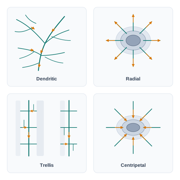
Fig. 3.2 – Four common drainage patterns.
Sorting India’s Rivers
India’s rivers are sorted in more than one way, and it helps to hold the three schemes together.
By where their water finally goes, they fall into two groups — the Arabian Sea drainage and the Bay of Bengal drainage. The two are parted by a water divide running along the Delhi ridge, the Aravali range (which stretches southwest from Delhi across Rajasthan) and the Sahyadris (the Western Ghats, close along the west coast). This divide is drawn as a line on the map of major rivers. The split is lopsided: nearly 77 per cent of the country’s drainage area — carried by the Ganga, the Brahmaputra, the Mahanadi, the Krishna and others — is oriented to the Bay of Bengal, while about 23 per cent — the Indus, the Narmada, the Tapi, the Mahi and the Periyar systems — drains to the Arabian Sea.
Map
Fig. 3.3 Caption: Major rivers of India. Brief: Reference map of India showing the major rivers and their courses, each named along its channel, from source to sea. Mark the water divide as a distinct line, with a key entry for it. Show the full extent of India as officially defined, with international boundaries, the Tropic of Cancer, and the surrounding seas — the Arabian Sea, the Bay of Bengal and the Indian Ocean — labelled. No thematic shading; this is a locational reference map.
By the size of their catchment, India’s basins fall into three classes. Major river basins have more than 20,000 sq. km of catchment area; there are 14 of them, including the Ganga, the Brahmaputra, the Krishna, the Tapi, the Narmada, the Mahi, the Pennar, the Sabarmati and the Barak. Medium river basins have between 2,000 and 20,000 sq. km, and there are 44, such as the Kalindi, the Periyar and the Meghna. Minor river basins have less than 2,000 sq. km, and take in a good number of rivers flowing through areas of low rainfall.
Reading the major-rivers map, you can trace how many rivers rise in the Himalayas and pour into either the Bay of Bengal or the Arabian Sea, while the large rivers of the Peninsular plateau rise in the Western Ghats and run east to the Bay of Bengal. The Narmada and the Tapi are the exceptions: they, along with many small rivers of the western coast from the Konkan down to the Malabar coast, run west into the Arabian Sea instead.
The third way of sorting — the one this book follows — is by how the rivers came to be: the Himalayan drainage and the Peninsular drainage. The scheme is not tidy, because it has to house rivers like the Chambal, the Betwa and the Son, which are far older in age and origin than the Himalayan rivers yet are grouped with them. Even so, it is the most widely accepted basis, and it is the one used here. The three schemes are drawn together in Fig. 3.4.
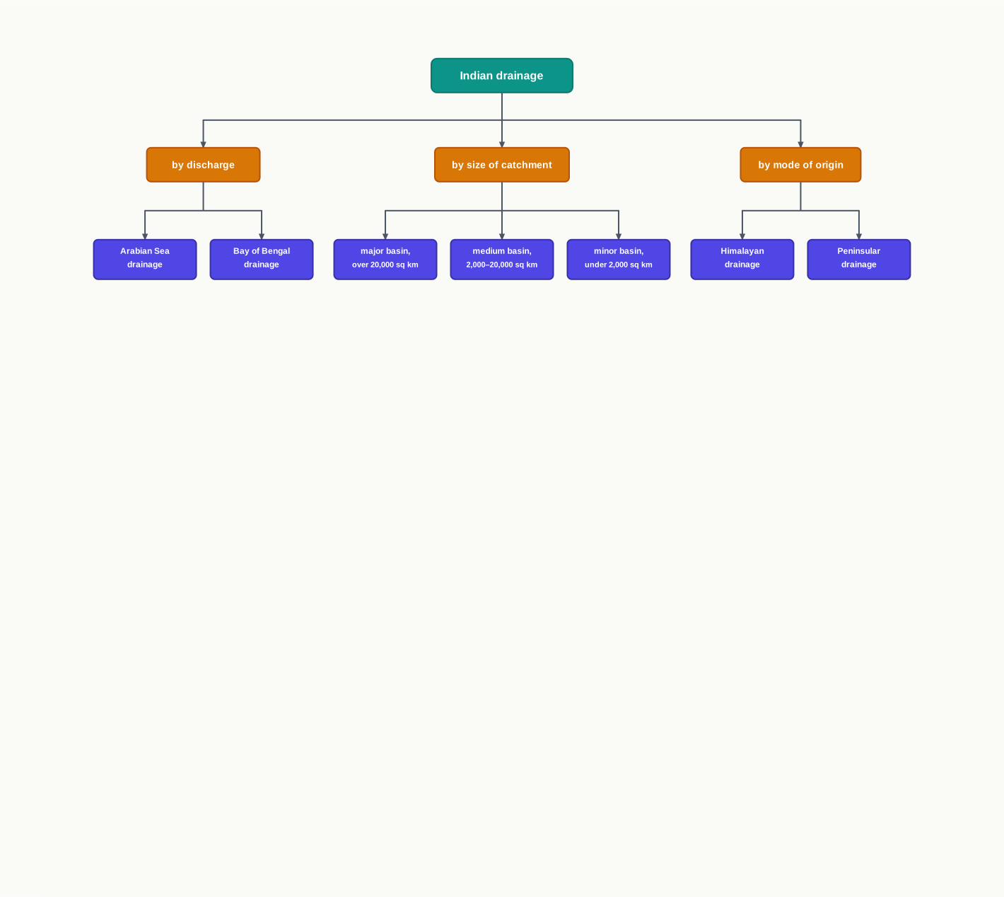
Fig. 3.4 – Three ways of classifying Indian drainage.
3.2 Drainage Systems Of India
India’s drainage is not one system but many — a great number of rivers, large and small, spread across the whole country. Taken together, they are the product of two things acting on each other over a long stretch of time: the land the rivers cross, and the rainfall they receive.
The land comes in three broad physiographic units — the young, high mountains of the Himalayas in the north; the flat, river-built plains below them; and the old, worn plateau of the Peninsula to the south. Each of these shapes its rivers in a different way, which is why the chapter tells the Himalayan and the Peninsular drainage as two separate stories.
Precipitation — how much falls, and when — settles how those rivers behave across the year. A river fed by melting mountain snow as well as by rain keeps flowing even through the dry months. A river that depends on the seasonal monsoon alone swells in the rains and shrinks once they end. This is why the country’s rivers split so sharply into the ones that never run dry and the ones that nearly do.
The rest of the chapter takes these two great systems in turn — first the Himalayan drainage, then the Peninsular.
3.3 The Himalayan Drainage
The Himalayan drainage system has taken shape over a long geological history. It is built mainly around three great river basins — the Ganga, the Indus and the Brahmaputra. Because these rivers are fed both by melting snow and by rainfall, they are perennial: even in the driest months, the high snowfields keep water moving down their channels.
Cutting Through Rising Mountains
High in the mountains, these rivers do the work of cutting down. They run through giant gorges — deep, steep-walled clefts — carved out by their own erosion even as the Himalayas were being pushed up; the cutting and the uplift went on at the same time. Where the sides are less sheer, the rivers open out V-shaped valleys, so called because the cross-section looks like the letter V — a sign of a young river biting downward into the rock. In the steepest reaches the water tumbles over rock steps as rapids (Fig. 3.5).
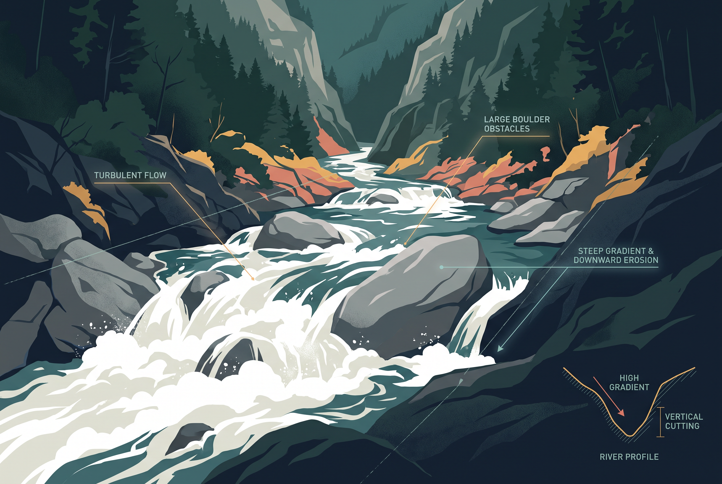
Fig. 3.5 – Rapids on a mountain river.
From Mountain To Mouth
When the rivers leave the mountains and reach the plains, their work changes from cutting to building. The slope flattens, the water slows, and the load it was carrying settles out. Here the rivers lay down depositional features: flat, wide valleys; ox-bow lakes, the curved, cut-off remains of old loops the river has abandoned; flood plains, the low, silt-built land beside the channel that the river covers when it overflows; and braided channels, where the stream splits around banks of its own sediment into many interweaving threads. Near the mouth, where the river meets the sea and drops the last of its load, it builds a delta. Fig. 3.6 traces how the same river changes its task from the mountains to the sea.
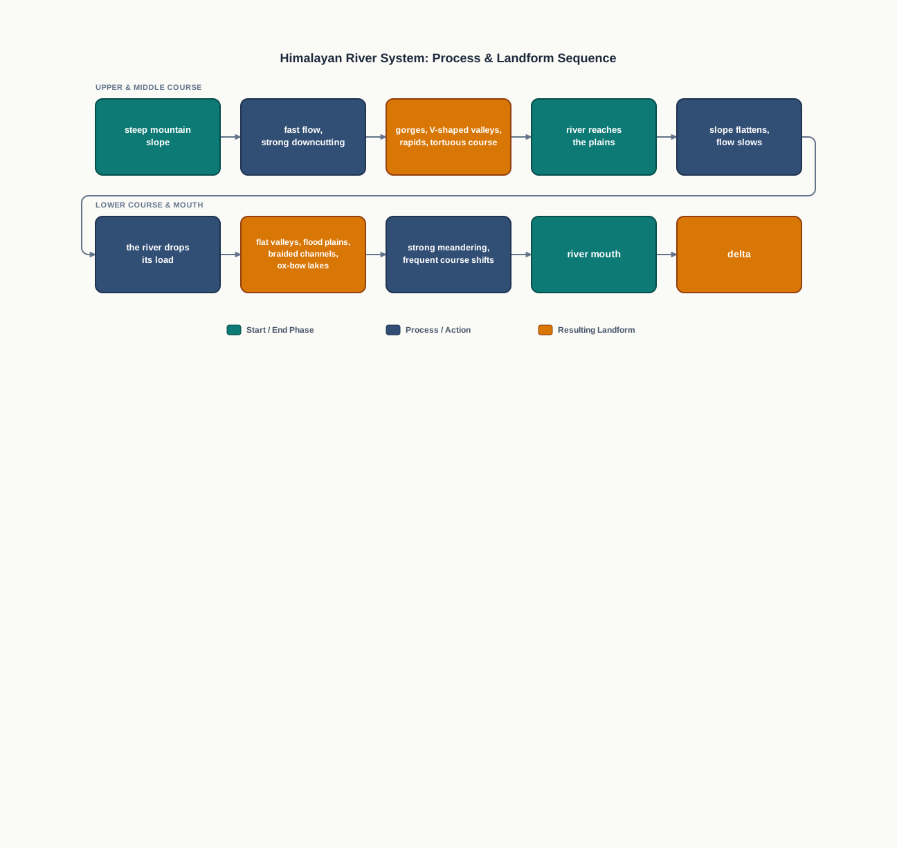
Fig. 3.6 – River actions and landforms from mountain to sea.
Rivers That Wander
In the mountains the course of these rivers is highly tortuous, twisting sharply to follow the rock. On the open plains they swing the other way, meandering in broad loops and shifting their channels from one season to the next. The Kosi, in northern Bihar, is the most notorious of them, long known as the ‘sorrow of Bihar’ for the way it keeps abandoning one course for another. It carries an enormous load of sediment down from its upper reaches and dumps it on the plains; the bed clogs, the channel blocks, and the river swings to a new path.
The discharge — the amount of water a river carries past a point — is not steady through the year. It rises and falls with the seasons, running highest when the summer snowmelt and the monsoon rains arrive together. When that happens, the excess spills over the banks. Flooding does both harm and good: it drowns fields and homes, which is the reason Bihar speaks of the Kosi as a sorrow, yet the same water spreads fresh silt that builds and renews the plains.
3.4 Evolution Of The Himalayan Drainage
Geologists do not fully agree on how the Himalayan rivers came to run as they do today. The most widely held view begins with a single enormous river.
The Great River That Once Was
On this view, one mighty river — called the Shiwalik, or the Indo-Brahma — once flowed along the entire length of the Himalaya. It ran from Assam in the east, across to Punjab, and on to Sind, finally emptying into the Gulf of Sind on the northwestern edge of the subcontinent. It did so during the Miocene, a stretch of geological time roughly 5 to 24 million years ago.
The evidence for such a river lies in the ground. Along the Shiwaliks — the low, outermost foothills that run in front of the main Himalayas — the deposits are remarkably continuous from one end of the range to the other. They are lacustrine, meaning laid down in lakes, and alluvial, meaning left behind by flowing river water. They are made of sands, silt, clay, boulders and conglomerates — rock formed of rounded pebbles cemented together. So long and unbroken a belt of river-and-lake sediment is just what a single great river, running the whole length, would leave behind.
How The One Became Three
In due course this single river was broken apart — dismembered — into the three systems we know today: the Indus and its five tributaries in the western part, the Ganga and its Himalayan tributaries in the central part, and the Brahmaputra in Assam with its Himalayan tributaries in the east.
The breaking was the work of the land itself rising and sinking. During the Pleistocene, a far more recent epoch, an upheaval in the western Himalayas lifted the Potwar Plateau — the Delhi Ridge. This raised ground became a water divide, parting the Indus drainage in the west from the Ganga drainage in the centre. Later, in the mid-Pleistocene, the ground was thrust down at the Malda gap — the low break between the Rajmahal hills in the east and the Meghalaya plateau to their northeast. That sinking turned the Ganga and the Brahmaputra away from their old westward line and set them running toward the Bay of Bengal. Fig. 3.7 follows the whole sequence.
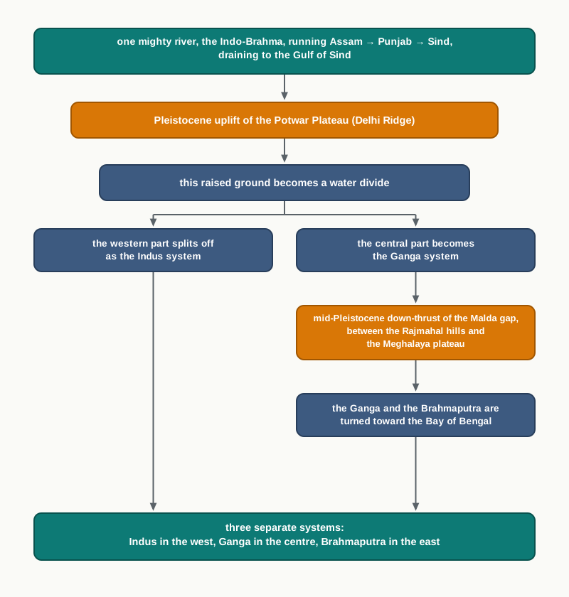
Fig. 3.7 – Evolution of the three Himalayan river systems.
3.5 The River Systems Of The Himalayan Drainage
The Himalayan drainage is made up of several river systems, but three stand out as the major ones — the Indus, the Ganga and the Brahmaputra. Each rises in the high mountains, gathers a crowd of tributaries, and carries their combined water to the sea. You can follow all three, and the water divide between them, on the major-rivers map (Fig. 3.3).
3.5.1 The Indus System
The Indus is one of the largest river basins in the world, covering 11,65,000 sq. km in all — of which 3,21,289 sq. km lie in India — with a total length of 2,880 km, of which 1,114 km run through India. Also called the Sindhu, it is the westernmost of the Himalayan rivers in India. It rises from a glacier near Bokhar Chu, at 31°15’ N and 81°40’ E, high in the Tibetan region at an altitude of 4,164 m in the Kailash mountain range. In Tibet it is called ‘Singi Khamban’, the Lion’s Mouth.
From its source the Indus runs northwest between the Ladakh and Zaskar ranges, then crosses Ladakh and Baltistan. It saws clean through the Ladakh range in a spectacular gorge near Gilgit, and enters Pakistan near Chilas in the Dardistan region — a name worth finding on a map.
The Gathering Of The Tributaries
Along the mountains the Indus takes in a string of Himalayan tributaries — the Shyok, the Gilgit, the Zaskar, the Hunza, the Nubra, the Shigar, the Gasting and the Dras. It emerges from the hills near Attock, where the Kabul river joins it on the right bank. Other right-bank tributaries — the Khurram, the Tochi, the Gomal, the Viboa and the Sangar — come down from the Sulaiman ranges to the west. Flowing south, the river receives the Panjnad a little above Mithankot, and finally discharges into the Arabian Sea, east of Karachi. Within India, the Indus flows only through the Union Territories of Ladakh and Jammu and Kashmir.
The Five Rivers Of Punjab
The Panjnad is the single stream formed when the five rivers of Punjab join together: the Satluj, the Beas, the Ravi, the Chenab and the Jhelum. It is worth seeing how they gather.
The Jhelum rises from a spring at Verinag, at the foot of the Pir Panjal in the southeastern part of the Kashmir valley. It runs through Srinagar and the Wular lake, then leaves for Pakistan through a deep, narrow gorge, joining the Chenab near Jhang. The Chenab is the largest of the Indus tributaries. It is born where two streams, the Chandra and the Bhaga, meet at Tandi near Keylong in Himachal Pradesh — which is why it is also called the Chandrabhaga — and it flows 1,180 km before crossing into Pakistan.
The Ravi rises west of the Rohtang pass in the Kullu hills of Himachal Pradesh and runs through the Chamba valley, draining the land between the southeastern Pir Panjal and the Dhauladhar ranges before entering Pakistan to join the Chenab near Sarai Sidhu. The Beas begins at the Beas Kund near the Rohtang Pass, at 4,000 m above sea level, flows through the Kullu valley, cuts gorges at Kati and Largi in the Dhauladhar range, and meets the Satluj near Harike on the Punjab plains.
The Satluj rises in the ‘Raksas tal’ near Mansarovar in Tibet, at an altitude of 4,555 m, where it is called Langchen Khambab. It runs nearly parallel to the Indus for about 400 km before entering India, emerging from a gorge at Rupar after passing through the Shipki La on the Himalayan ranges. It is an antecedent river — one that was already flowing before the mountains rose across its path, and cut downward fast enough, as the land was pushed up, to hold its old course and saw a gorge straight through the rising rock. The Satluj matters greatly because it feeds the canal system of the Bhakra Nangal project.
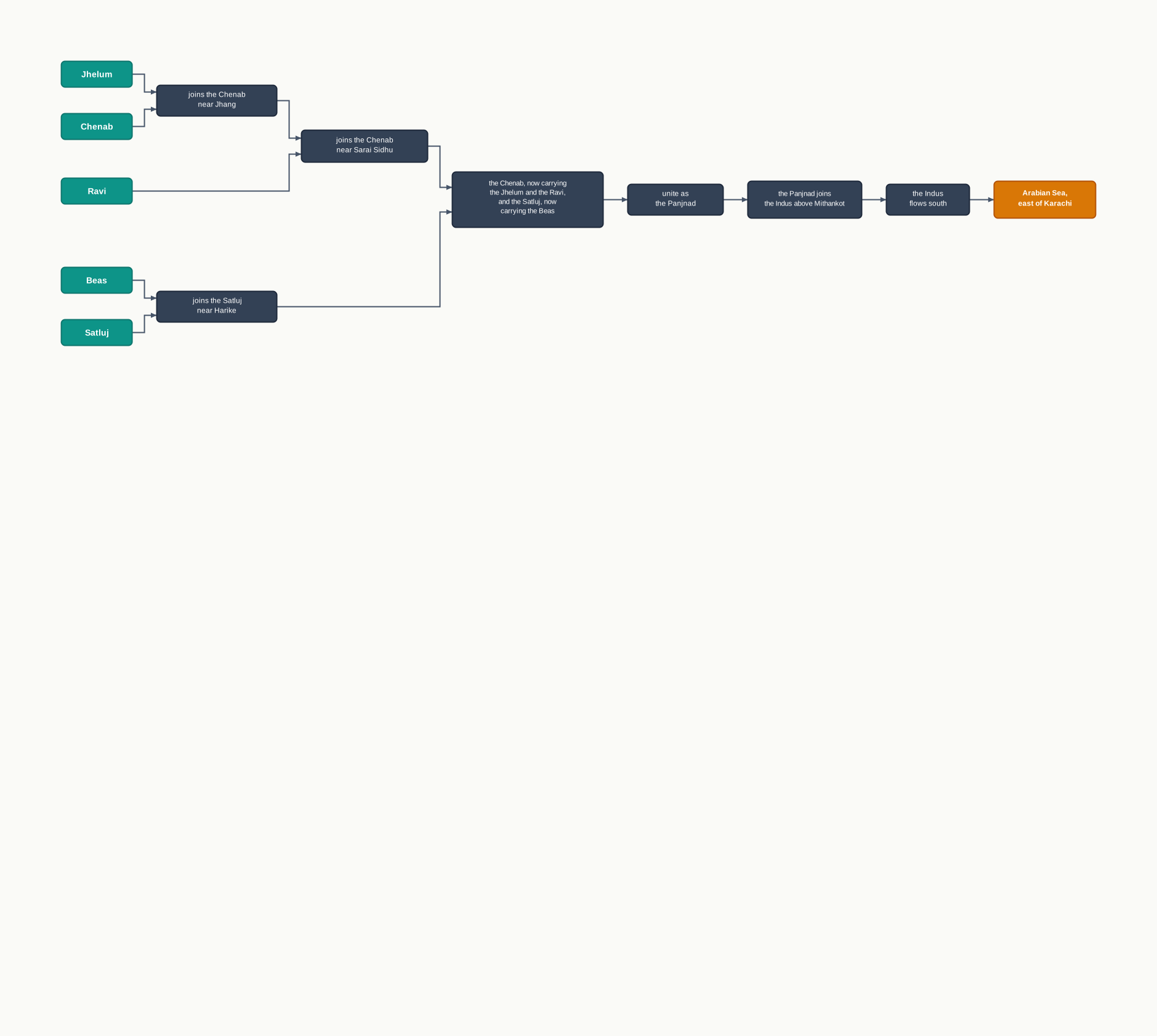
Fig. 3.8 – The gathering of the Punjab rivers into the Indus.
3.5.2 The Ganga System
The Ganga is the most important river of India, both for the size of its basin and for its cultural significance. It rises in the Gangotri glacier near Gaumukh, at 3,900 m in the Uttarkashi district of Uttarakhand, where it is first called the Bhagirathi. It cuts through the Central and Lesser Himalayas in narrow gorges. At Devprayag the Bhagirathi meets the Alaknanda, and from that meeting onward the united river is the Ganga.
The Alaknanda has its own gathering upstream. Its source is the Satopanth glacier above Badrinath; it is made of the Dhauli and the Vishnu Ganga, which meet at Joshimath, also called Vishnu Prayag. The Pindar joins the Alaknanda at Karna Prayag, and the Mandakini, or Kali Ganga, meets it at Rudra Prayag. The Ganga steps down onto the plains at Haridwar. From there it runs first south, then southeast and east, before splitting into two distributaries — channels that branch off and carry the water away separately — namely the Bhagirathi and the Padma.
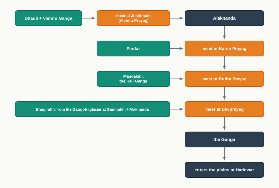
Fig. 3.9 – The headstreams of the Ganga.
The Ganga is 2,525 km long. Its course is shared by four states — Uttarakhand (110 km), Uttar Pradesh (1,450 km), Bihar (445 km) and West Bengal (520 km) — and its basin covers about 8.6 lakh sq. km within India alone. This is the largest river system in the country, carrying both perennial and non-perennial rivers: the perennial ones rise in the Himalayas to the north, the non-perennial ones on the Peninsula to the south. The Son is its major right-bank tributary, while its important left-bank tributaries are the Ramganga, the Gomati, the Ghaghara, the Gandak, the Kosi and the Mahananda. The river finally empties into the Bay of Bengal near Sagar Island.
The Yamuna And Its Tributaries
The Yamuna is the westernmost and the longest tributary of the Ganga. It rises in the Yamunotri glacier on the western slopes of the Banderpunch range (6,316 m) and joins the Ganga at Prayag (Allahabad). On its right bank it receives the Chambal, the Sind, the Betwa and the Ken, all of which rise on the Peninsular plateau; on its left bank it takes the Hindan, the Rind, the Sengar and the Varuna. Much of the Yamuna’s water is drawn off into the western and eastern Yamuna canals and the Agra canal for irrigation.
The Chambal rises near Mhow in the Malwa plateau of Madhya Pradesh and flows north through a gorge above Kota in Rajasthan, where the Gandhisagar dam has been built. From Kota it runs on to Bundi, Sawai Madhopur and Dholpur, and finally joins the Yamuna. The Chambal is famous for its badland topography — the deeply gullied, broken land known as the Chambal ravines.
More Tributaries Of The Ganga
The Gandak is made of two streams, the Kaligandak and the Trishulganga. It rises in the Nepal Himalayas between Dhaulagiri and Mount Everest, drains the central part of Nepal, enters the Ganga plain in the Champaran district of Bihar, and joins the Ganga at Sonpur near Patna.
The Ghaghara begins in the glaciers of Mapchachungo. After gathering its tributaries — the Tila, the Seti and the Beri — it comes out of the mountains through a deep gorge at Shishapani. The Sarda (also called Kali or Kali Ganga) joins it on the plains before it finally meets the Ganga at Chhapra.
The Kosi is an antecedent river. Its main stream, the Arun, rises to the north of Mount Everest in Tibet; after crossing the Central Himalayas in Nepal it is joined by the Son Kosi from the west and the Tamur Kosi from the east, and on uniting with the Arun it forms the Sapt Kosi — the ‘seven Kosis’.
The Ramganga is a comparatively small river that rises in the Garhwal hills near Gairsain. After crossing the Shiwalik it turns southwest, enters the plains of Uttar Pradesh near Najibabad, and finally joins the Ganga near Kannauj.
The Damodar runs along the eastern margins of the Chotanagpur plateau, in eastern India, flowing through a rift valley — a long trough where the land has dropped between two faults — before joining the Hugli. Its main tributary is the Barakar. Once known as the ‘sorrow of Bengal’, the Damodar has since been tamed by the Damodar Valley Corporation, a multipurpose project — one built to serve several purposes at once.
The Sarda, or Saryu, rises in the Milam glacier in the Nepal Himalayas, where it is called the Goriganga. Along the Indo-Nepal border it is known as the Kali or the Chauk, and there it joins the Ghaghara.
The Mahananda rises in the Darjiling hills and joins the Ganga as its last left-bank tributary, in West Bengal. The Son is a large south-bank tributary; it rises in the Amarkantak plateau, forms a series of waterfalls at the edge of the plateau, and reaches the Ganga at Arrah, west of Patna.
3.5.3 The Brahmaputra System
The Brahmaputra is one of the largest rivers in the world. It rises in the Chemayungdung glacier of the Kailash range, near the Mansarovar lake, and then runs eastward for nearly 1,200 km through a dry, flat stretch of southern Tibet, where it is called the Tsangpo — ‘the purifier’. Its major right-bank tributary in Tibet is the Rango Tsangpo. The river turns turbulent only after it carves a deep gorge through the Central Himalayas near Namcha Barwa (7,755 m).
Coming out of the foothills, it is first called the Siang or Dihang, and it enters India west of Sadiya town in Arunachal Pradesh. Flowing southwest, it takes in its main left-bank tributaries — the Dibang, or Sikang, and the Lohit — and only after that is it known as the Brahmaputra.
Across the Assam valley, in a journey of about 750 km, the river gathers many tributaries. Its major left-bank tributaries are the Burhi Dihing and the Dhansari (South); its important right-bank tributaries are the Subansiri, the Kameng, the Manas and the Sankosh. The Subansiri, which rises in Tibet, is another antecedent river. The Brahmaputra then enters Bangladesh near Dhubri and turns south. There the Tista joins it on the right bank, and from that point the river is called the Jamuna; it finally merges with the Padma, which pours into the Bay of Bengal.
The Brahmaputra is well known for its floods, its shifting channels and its eroded banks. The reason lies in its tributaries: most of them are large, and they bring down huge quantities of sediment because rainfall in the catchment is so heavy.
3.6 The Peninsular Drainage System
The Peninsular drainage system is older than the Himalayan one. You can read its age in the land: the valleys are broad, shallow and largely graded — worn down over so long a time that their beds have settled into a smooth, gentle profile — and the rivers themselves are mature, no longer cutting hard but moving steadily along fixed paths.
The Western Ghats, running close along the western coast, act as the water divide for the major Peninsular rivers. The large rivers rise on the Ghats and run east to discharge into the Bay of Bengal, while only small rivulets run down the short western slope to the Arabian Sea. Most of the major Peninsular rivers, except the Narmada and the Tapi, therefore flow from west to east. Some rivers rising in the northern part of the Peninsula — the Chambal, the Sind, the Betwa, the Ken and the Son — do not belong to this system at all; they drain northward into the Ganga.
Compared with the Himalayan rivers, the Peninsular rivers behave very differently. They keep to a fixed course, they lack the wide meanders of the plains rivers, and their flow is non-perennial — full in the rains and very low, sometimes dry, once the rains end. The Narmada and the Tapi, which flow through rift valleys, are the exceptions to much of this.
3.6.1 The Evolution Of Peninsular Drainage System
Three major geological events in the distant past shaped the drainage of Peninsular India as we see it today.
First, the western flank of the Peninsula subsided and slipped below the sea during the early Tertiary period. This drowned one side of the block and, in doing so, upset the once-symmetrical arrangement of rivers on either side of the original watershed.
Second, the upheaval that raised the Himalayas pressed the northern flank of the Peninsular block down, and the crust there broke along faults, forming long troughs. A trough fault is a strip of ground that has slipped down between two roughly parallel faults, leaving a steep-sided trench. The Narmada and the Tapi run along such troughs, filling the cracks with their own detritus — the loose rock waste they carry. Because they are busy filling faults rather than building up plains, these two rivers lay down almost no alluvial or deltaic deposits.
Third, the whole Peninsular block was tilted slightly, from the north-west down towards the south-east. That gentle slope, set during the same period, turned the entire drainage system towards the Bay of Bengal — which is why so many of the Peninsula’s rivers run east.
3.6.2 River Systems Of The Peninsular Drainage
The Peninsular drainage holds a great many river systems. The major ones are set out below, and their lengths are compared in Fig. 3.10.
Graph
Fig. 3.10 Caption: Lengths of the major Peninsular rivers. Brief: Horizontal bar chart. The y-axis lists the rivers; the x-axis is length in kilometres, beginning at zero. Bars — Godavari 1,465 km, Krishna 1,401 km, Narmada 1,312 km, Mahanadi 851 km, Kaveri 800 km, Tapi 724 km. Order the bars from longest to shortest and label each with its value. Source: the river lengths stated in this chapter.
The East-Flowing Rivers
The Mahanadi rises near Sihawa in the Raipur district of Chhattisgarh and runs through Odisha to discharge into the Bay of Bengal. It is 851 km long, and its catchment spreads over 1.42 lakh sq. km. Some navigation is carried on in its lower course. Fifty-three per cent of its drainage basin lies in Madhya Pradesh and Chhattisgarh, and 47 per cent in Odisha.
The Godavari is the largest Peninsular river system, and for its size it is also called the Dakshin Ganga — the Ganga of the South. It rises in the Nasik district of Maharashtra and discharges into the Bay of Bengal. Its tributaries run through Maharashtra, Madhya Pradesh, Chhattisgarh, Odisha and Andhra Pradesh. It is 1,465 km long, with a catchment of 3.13 lakh sq. km — 49 per cent of it in Maharashtra, 20 per cent in Madhya Pradesh and Chhattisgarh, and the rest in Andhra Pradesh. Its principal tributaries are the Penganga, the Indravati, the Pranhita and the Manjra. The Godavari suffers heavy floods in its lower reaches south of Polavaram, where it forms a picturesque gorge; it is navigable only in the deltaic stretch, and after Rajamundri it splits into several branches to build a large delta.
The Krishna is the second largest east-flowing Peninsular river. It rises near Mahabaleshwar in the Sahyadri (the Western Ghats) and runs 1,401 km in all. Its major tributaries are the Koyna, the Tungbhadra and the Bhima. Of its total catchment, 27 per cent lies in Maharashtra, 44 per cent in Karnataka, and 29 per cent in Andhra Pradesh and Telangana.
The Kaveri rises in the Brahmagiri hills (1,341 m) of Kogadu district in Karnataka. It is 800 km long and drains 81,155 sq. km. It has an unusual advantage: its upper catchment gets rain from the south-west monsoon in summer, while its lower part gets rain from the north-east monsoon in winter. Fed at both ends in turn, it carries water through the whole year, with far less fluctuation than the other Peninsular rivers. About 3 per cent of its basin falls in Kerala, 41 per cent in Karnataka and 56 per cent in Tamil Nadu. Its important tributaries are the Kabini, the Bhavani and the Amravati.
The Westward Exceptions
The Narmada originates on the western flank of the Amarkantak plateau at about 1,057 m. It flows in a rift valley between the Satpura range to the south and the Vindhyan range to the north, cutting a picturesque gorge through marble rocks and dropping over the Dhuandhar waterfall near Jabalpur. After a course of about 1,312 km it meets the Arabian Sea south of Bharuch, forming a broad estuary 27 km long. An estuary is the wide, tidal mouth of a river where it meets the sea — the opposite kind of mouth to a delta. A delta is built where a river drops so much sediment that it splits into branches over its own deposits; an estuary forms where the river keeps a single funnel-shaped mouth and lays down little. The Narmada, flowing in a rift valley and carrying little loose sediment, makes an estuary rather than a delta. Its catchment is about 98,796 sq. km, and the Sardar Sarovar Project has been built on it. You could collect information about the river-conservation mission named ‘Namami Devi Narmade’ and discuss it with your classmates.
The Tapi is the other important westward-flowing river. It originates from Multai in the Betul district of Madhya Pradesh, runs 724 km, and drains 65,145 sq. km. Nearly 79 per cent of its basin lies in Maharashtra, 15 per cent in Madhya Pradesh and the remaining 6 per cent in Gujarat.
The Luni is the largest river system of Rajasthan, lying west of the Aravali. It rises near Pushkar in two branches, the Saraswati and the Sabarmati, which join each other at Govindgarh. From there the combined river comes out of the Aravali and is called the Luni. It flows west as far as Telwara, then turns south-west to reach the Rann of Kuchchh, the great salt marsh of Gujarat. The entire Luni system is ephemeral, carrying water only after the rains.
3.7 Extent Of Usability Of River Water
India’s rivers carry an enormous volume of water every year. The trouble is that the water is spread very unevenly — unevenly in time, and unevenly in space. Some rivers are perennial and flow all year; the non-perennial ones hold very little through the dry season. In the rains, so much water comes down at once that much of it is simply wasted, spilling over as floods and running off to the sea before anyone can use it.
Too Much And Too Little
The strangest part is that flood and drought can strike the country at the same time — one region drowning under too much water while another, not far away, is parched for want of it. Is this a shortage of the resource itself, or a failure to manage what we have? It is worth asking what measures could ease floods and droughts that occur together in different parts of the country. (This is taken up in Chapter 6 of the book.)
Can We Move Water Around?
One proposed answer is inter-basin linkage — carrying surplus water from a basin that has more than it needs to a deficit basin that has too little, through canals that link the two. Several such schemes have been discussed or built, among them the Periyar Diversion Scheme, the Indira Gandhi Canal Project, the Kurnool-Cuddapah Canal, the Beas-Satluj Link Canal and the Ganga-Kaveri Link Canal.
But digging a canal is rarely enough on its own. To carry water from the Ganga basin across to a Peninsular river, the water would have to cross uneven terrain, and in places be lifted from the low plains up onto the higher plateau — which takes energy and money, not just a channel. There is also the harder question of whether the north Indian rivers actually hold enough dependable surplus to be transferred, year after year, on a regular basis. And rivers shared between states are often disputed. These are questions worth debating rather than settling quickly.
It helps to see how many different problems crowd around river water at once. Try ranking these for yourself, from the most serious to the least: no water available in sufficient quantity; river-water pollution; the load of silt carried in the water; the uneven seasonal flow of the rivers; disputes over river water between states; and the shrinking of channels as settlements creep towards the thalweg — the line of deepest points running down the middle of a river’s channel, the last place a channel should be built over.
Why The Rivers Are Polluted
River pollution is a problem anyone can see. The dirty waste water of cities drains straight into the rivers. Industrial effluents — the liquid wastes that factories discharge — are dumped into them. Many cremation grounds stand on the riverbanks, and the dead are sometimes placed in the water; at certain festivals, flowers and statues are immersed in the rivers; and large-scale bathing and the washing of clothes add to the load. Each of these, small on its own, adds up to heavily fouled water.
How can the rivers be made clean again? You may have read about the Ganga Action Plan, or about the campaign to clean the Yamuna at Delhi. It is worth collecting material on the different schemes for making rivers pollution-free and setting down what you find.
3.8 Summary
- Drainage is the flow of water through well-defined channels, and the whole network of such channels is a drainage system. The pattern it takes depends on geological time, the rock, the slope, the amount of water and how steady the flow is.
- The area a river drains is its drainage basin; the high ground dividing one basin from the next is the watershed. Because a basin acts as a single unit, it makes a natural region for planning land and water.
- Rivers lay themselves out in recognisable patterns — dendritic, radial, trellis and centripetal — decided by the slope and the rock beneath.
- India’s rivers can be sorted three ways: by where they discharge (about 23 per cent to the Arabian Sea, about 77 per cent to the Bay of Bengal), by the size of their basins (major, medium and minor), and by their origin (Himalayan or Peninsular — the scheme this book follows).
- Himalayan rivers are perennial, fed by melting snow as well as rain. They cut gorges and V-shaped valleys in the mountains, then build flood plains, ox-bow lakes, braided channels and deltas on the plains, often shifting their course, as the Kosi does.
- The Himalayan system may have grown from one ancient river, the Indo-Brahma, later broken by earth movements into the Indus, the Ganga and the Brahmaputra systems.
- The Indus and its Panjnad — the five rivers of Punjab — drain the west; the Ganga, the largest system, gathers tributaries from both the Himalayas and the Peninsula; the Brahmaputra, heavy with sediment, drains the east and is prone to floods and shifting channels.
- The Peninsular drainage is older, with non-perennial rivers, fixed courses and broad graded valleys. Three geological events tilted the block towards the south-east, so most of its rivers run east into the Bay of Bengal.
- The Narmada, the Tapi and the Luni are the westward exceptions, draining to the Arabian Sea. Flowing in rift valleys and carrying little loose sediment, the Narmada and the Tapi form estuaries rather than deltas.
- River water is spread unevenly in time and space, so floods and droughts can strike different parts of the country at once. Inter-basin links, better management and pollution control are the debated responses.
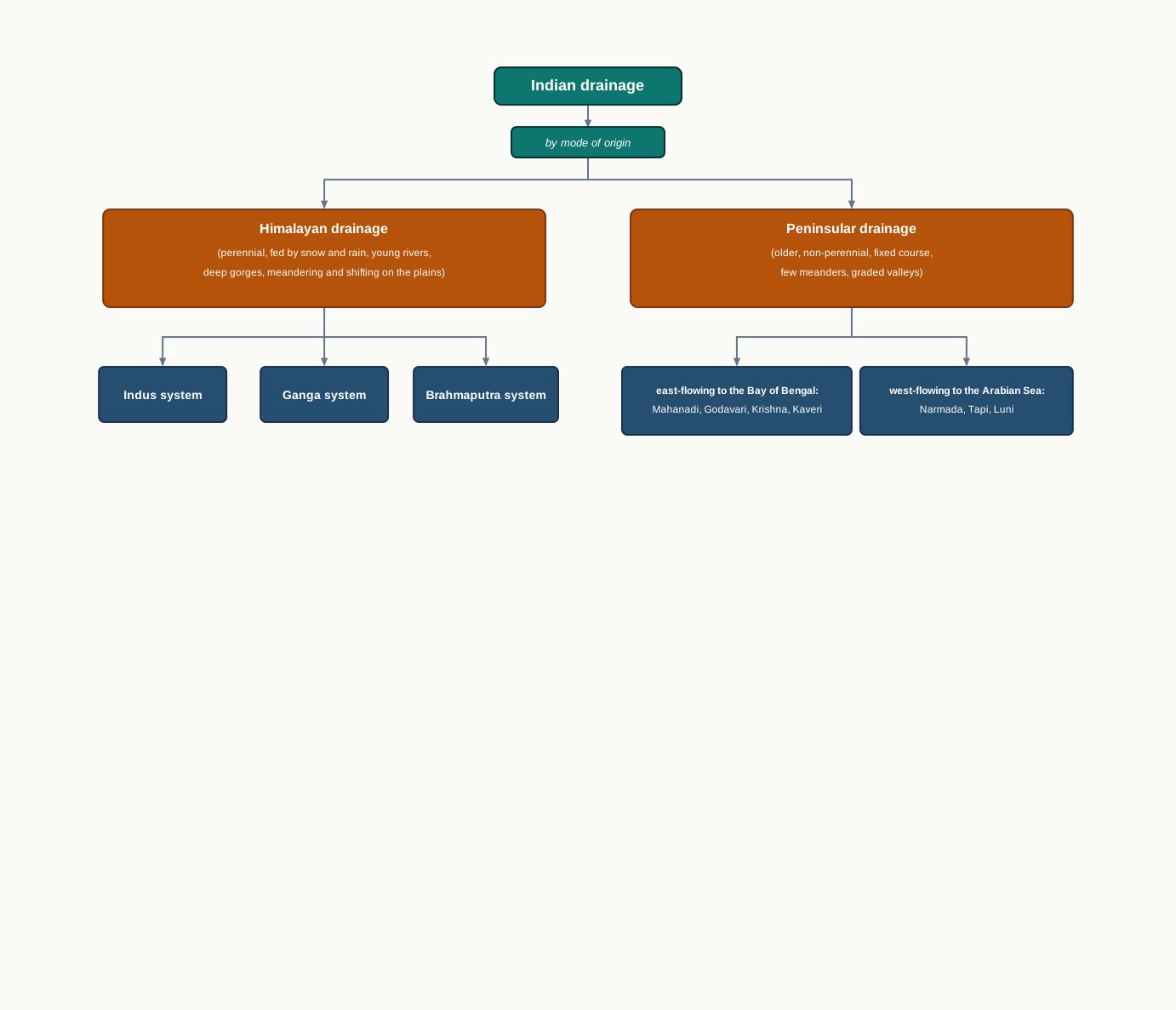
Fig. 3.11 – Indian drainage by mode of origin.
What This Chapter Cannot Tell You
A length or a catchment figure lets you rank rivers by size on paper, but it says nothing about how much water each one actually carries, or how that water is shared across the seasons.
The tidy split into Himalayan and Peninsular hides the awkward cases the chapter itself admits — old, Peninsular-born rivers like the Chambal, the Betwa and the Son that drain not to the sea nearby but into the Ganga.
A national picture of ‘surplus’ and ‘deficit’ basins smooths over the local reality, where the same district can flood one month and run short of water the next.
3.9 NCERT Questions
Which one of the following rivers was known as the ‘Sorrow of Bengal’?
- The Gandak
- The Son
- The Kosi
- The Damodar
Which one of the following rivers has the largest river basin in India?
- The Indus
- The Brahmaputra
- The Ganga
- The Krishna
Which one of the following rivers is not included in ‘Panchnad’?
- The Ravi
- The Chenab
- The Indus
- The Jhelum
Which one of the following rivers flows in a rift valley?
- The Son
- The Narmada
- The Yamuna
- The Luni
Which one of the following is the place of confluence of the Alaknanda and the Bhagirathi?
- Vishnu Prayag
- Rudra Prayag
- Karan Prayag
- Deva Prayag
State the differences between the following.
- River Basin and Watershed.
- Dendritic and Trellis drainage pattern.
- Radial and Centripetal drainage pattern.
- Delta and Estuary.
What are the socio-economic advantages of inter-linking of rivers in India? (about 30 words)
Write three characteristics of the Peninsular river. (about 30 words)
What are the important characteristic features of north Indian rivers? How are these different from Peninsular rivers? (not more than 125 words)
Suppose you are travelling from Haridwar to Siliguri along the foothills of the Himalayas. Name the important rivers you will come across. Describe the characteristics of any one of them. (not more than 125 words)
3.10 Check Your Concepts
On Fig. 3.3, find the line marked as the water divide. Name one river on each side of it, and state which sea — the Arabian Sea or the Bay of Bengal — each of those rivers reaches.
The chapter gives the Ganga’s length as shared by four states: Uttarakhand 110 km, Uttar Pradesh 1,450 km, Bihar 445 km and West Bengal 520 km. Add these four lengths, and check that your total matches the river’s stated length of 2,525 km.
What is an antecedent river? Using an example named in the chapter, explain how a river can be older than the mountains it now cuts straight through.
Most Peninsular rivers run very low in the dry season, yet the Kaveri carries water fairly evenly through the year. Explain why, using what the chapter says about the rainfall its upper and lower catchments receive.
Arrange in the correct order the steps by which the Kosi comes to change its course: from the sediment it carries down, to the flooding of the plains. Explain what happens at each step.
The chapter gives each river’s length in kilometres. Using what it says about perennial and non-perennial flow, explain why a river’s length alone does not tell you how much water it carries through the year.