Chapter 4: Climate
Every year, in the last week of May, the air over the Kerala coast grows heavy and still. The heat built up through April and May sits like a lid over the land, and the sea to the west is warm and full of moisture. Then, usually in the first week of June, it breaks.
A wall of dark cloud rolls in off the sea. The sky splits with thunder and lightning, and the first rain of the season comes down in sheets. Within a day or two the daytime temperature falls by several degrees. This sudden, violent arrival has a name of its own — the ‘burst’ of the monsoon — and for the millions of farmers who have waited through the dry heat, it is the signal to begin sowing.
The rain does not stop at the coast. Over the following weeks the rain-bearing winds push northward and inland, until almost the whole country lies under cloud. Land that was cracked and brown in May turns green.
What makes this happen on roughly the same dates, year after year? Why do the winds that blew out of the northeast all winter now blow in from the southwest, loaded with ocean water? And why does the rain drench one hillside while a desert only a few hundred kilometres away stays dry? The monsoon is India’s central climatic fact, and this chapter follows the winds that carry it.
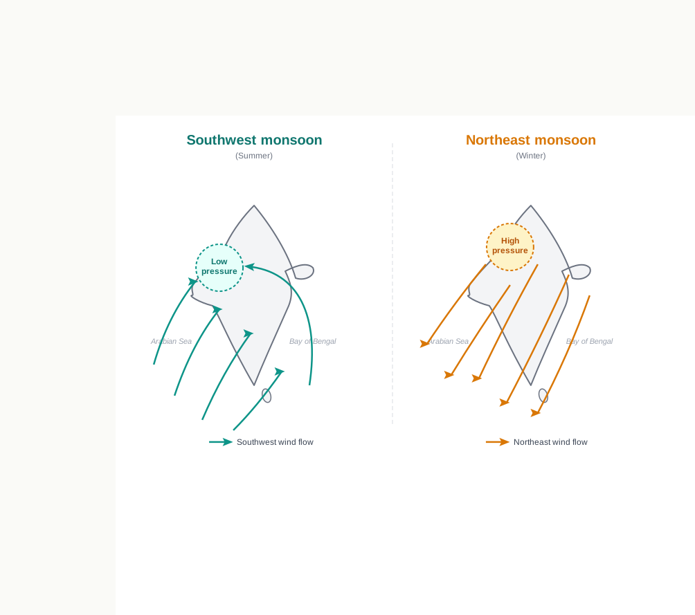
Fig. 4.0 – Seasonal reversal of the monsoon winds.
4.1 Weather, Climate And The Monsoon
Think about how differently you dress across a single year. In north India you reach for light cotton in summer and heavy woollens in winter. In the far south, woollens are barely needed at all, and across most of the northeastern states the winters stay mild — except up in the hills, where it is colder.
These everyday choices are a response to something changing above your head. The atmosphere is never still: its condition shifts from season to season, and from one part of the country to another. What is changing are the elements of weather — temperature, air pressure, the direction and speed of the wind, humidity (the amount of water vapour held in the air), and precipitation (water reaching the ground as rain, snow or hail). When any of these moves, the weather moves with it.
Weather Is Not Climate
Two words are easily muddled here, and it is worth pulling them apart. Weather is the momentary state of the atmosphere at a place — what the sky is doing right now, today, or this week. Climate is the average of those conditions taken over a long stretch of time.
The real difference between them is a difference of time-scale. Weather can turn within a day or a week; a clear morning becomes a wet afternoon. Climate changes so slowly that the shift is imperceptible — it may take fifty years or more before it can even be noticed. One unusually cold day tells you nothing about a place’s climate; only a run of decades could.
What Monsoon Means
You have already met the monsoon in earlier classes, and you know the word. It names a climate built around a seasonal reversal in the direction of the winds: for one part of the year the winds blow steadily from one quarter, and for the rest of the year they blow from the opposite quarter. In India they arrive warm and moist from the southwest in summer, and leave dry from the northeast in winter.
India has a hot monsoonal climate — hot because the country lies in low, strongly sun-warmed latitudes, and monsoonal because this reversal of the winds sets the rhythm of its whole year. The same climate is the prevalent one across south and southeast Asia, so India shares its basic climatic character with a broad belt of neighbouring lands.
4.2 Unity And Diversity In The Monsoon Climate
The monsoon ties India into one climatic family with the rest of the southeast Asian region. Because the same seasonal reversal of winds governs this whole belt, we can speak of a single monsoon type of climate stretching across many countries.
That broad unity, though, should not blind us to how varied India’s own weather is from place to place. The climate of Kerala and Tamil Nadu in the south feels nothing like that of Uttar Pradesh and Bihar in the north — and yet all four share the monsoon type of climate. The variation shows up in the pattern of winds, in temperature, in rainfall, in the rhythm of the seasons, and in the degree of wetness or dryness. These are best understood as sub-types of one monsoon climate, not as separate climates. Let us look closely at the variation in temperature, in winds and in rainfall.
Variation In Temperature
The spread of temperature across India is enormous. In summer the mercury occasionally touches 55°C in western Rajasthan, while in winter it falls to as low as minus 45°C around Leh, high up in Ladakh in the far north. The contrast can hold on a single day: on a June day Churu in Rajasthan may record 50°C or more, while at Tawang in Arunachal Pradesh, in the eastern Himalaya, the mercury hardly touches 19°C that same day. On a December night, Drass in Ladakh may drop to minus 45°C, while Thiruvananthapuram on the Kerala coast, or Chennai on the Tamil Nadu coast, records 20°C or 22°C on the same night.
All of these are differences from place to place and region to region. The gap between a place’s own hottest and coldest seasons is its annual range of temperature, and it is the interior and the north that carry the largest annual ranges, far from any softening influence.
The variation is just as striking within a single place across a single day. The difference between day and night temperature is called the diurnal range. In Kerala and in the Andaman Islands, out in the Bay of Bengal, that range may be only seven or eight degrees Celsius. But in the Thar desert of western Rajasthan, a daytime figure around 50°C can fall away to 15°–20°C by night — a diurnal range several times larger. So India’s temperature varies not only across the map but around the clock.
Variation In Precipitation
Precipitation varies not only in how much falls but in what kind falls. In the Himalayas the winter precipitation comes down as snow, while over the rest of the country it arrives as rain.
The amount varies even more dramatically. Cherrapunji and Mawsynram, in the Khasi Hills of Meghalaya in the northeast, receive over 1,080 cm of rain in a year. Jaisalmer, in the Thar desert of western Rajasthan, rarely gets more than 9 cm in the same period. Tura, in the Garo Hills of Meghalaya, may receive in a single day an amount of rain equal to ten years’ fall at Jaisalmer. Across the northwest Himalayas and the western deserts the annual precipitation is under 10 cm; in Meghalaya it exceeds 400 cm.
The rain is spread unevenly in time as well as in space. The Ganga delta in the east and the coastal plains of Odisha are struck by strong rain-bearing storms almost every third or fifth day through July and August, while the Coromandal coast — the southeastern coast, a thousand kilometres to the south — stays generally dry in those very months. Most of the country receives its rain between June and September; but along the Tamil Nadu coast the main rain holds off until the beginning of winter.
For all these contrasts — of temperature, of rainfall, of timing — the climate of India remains monsoonal in its rhythm and character. The variations are the many faces of one system, not many different systems at work.
4.3 Factors Determining The Climate Of India
India’s climate is not the work of one cause but of several acting together. Six factors, in particular, shape the temperature, pressure, winds and rainfall that you have just seen vary so widely across the country.
Latitude
India stretches across a broad band of latitude — a place’s distance, measured in degrees, north of the equator. The Tropic of Cancer, the line at about 23½°N, runs across the middle of the country in a roughly east-west direction, and this single line splits India’s climate in two.
The part lying south of the Tropic falls in the tropical zone, close to the equator. It stays hot through the year, with only a small daily and annual range of temperature. The part north of the Tropic lies in the sub-tropical and temperate zone, further from the equator, and has a more extreme climate with large daily and annual ranges. In short, the further a place sits from the equator, the sharper its swings between heat and cold.
The Himalayan Mountains
The lofty Himalayas in the north, together with their extensions, act as an effective climatic divide — a barrier that keeps the climate on one side unlike the climate on the other. The towering chain forms an almost unbroken shield. It blocks the bitterly cold winds that form near the Arctic circle and sweep across central and eastern Asia, holding them out of the subcontinent. The very same wall traps the rain-bearing monsoon winds coming from the opposite direction, forcing them to rise and shed their moisture over India instead of drifting beyond it.
Distribution Of Land And Water
India is flanked by the Indian Ocean on three sides in the south and walled off by a high, continuous mountain chain in the north. Land and water respond to the sun very differently: water heats up and cools down slowly, while land heats and cools quickly. This uneven response is called differential heating.
Because land and sea warm at different rates, they build up different air pressures as the seasons turn — low pressure over the fast-heating land in summer, higher pressure over the slower sea, and the reverse in winter. It is this seasonal difference in air pressure that reverses the direction of the monsoon winds. We will follow exactly how that happens in the next section.
Distance From The Sea
The sea is a moderating influence: it keeps the places near it mild. A climate that is gentle, with only small differences between the seasons and between day and night, is called an equable climate, and India’s long coastline gives its coastal belts exactly that. The people of Mumbai and the Konkan coast, on the west coast, have hardly any experience of temperature extremes or of sharp seasonal change.
Move inland, out of the sea’s reach, and the picture flips. Interior places such as Delhi, Kanpur and Amritsar, in the northern plains, feel the full seasonal contrast — scorching summers and cold winters — and that contrast reaches into the entire rhythm of life there.
Altitude
Temperature also falls as you climb. The air higher up is thinner, holds less heat, and so mountain places are cooler than places on the plains — even at the same latitude. The chapter’s own example makes the point sharply. Agra, on the plains, and Darjiling, high in the eastern Himalaya, sit on almost the same latitude; yet the January temperature at Agra is 16°C, while at Darjiling it is only 4°C.
Relief
The relief, or physiography, of India — the shape of the land, its mountains, plains and plateaus — also steers temperature, air pressure, the direction and speed of the wind, and above all the amount and distribution of rain. Where moist winds meet high ground, the slope facing the wind, the windward side, is forced to lift the air, which cools and rains heavily. The sheltered slope behind, the leeward side, is left dry.
You can see this along the Western Ghats, the range running down the west coast, and in Assam in the northeast: their windward slopes catch heavy rain from June to September. The southern plateau, sitting leeward of the Western Ghats, stays comparatively dry. Relief, then, decides not only how much rain falls but exactly where it falls.
4.4 The Nature Of Indian Monsoon
The monsoon is familiar to everyone in India, and yet it is still not fully understood. Despite centuries of observation it continues to puzzle scientists, and no single theory has managed to explain it completely. The real breakthrough came only recently, when the monsoon was studied at the global scale rather than as a purely regional, South Asian event. Looking at the circulation of the whole planet, instead of India alone, is what began to unlock it.
Careful studies of the causes of rainfall over South Asia have brought two features of the monsoon into focus, and both are worth examining closely: its onset — the way it arrives — and the breaks within it, when the rain pauses in the middle of the season.
4.4.1 Onset Of The Monsoon
Towards the end of the nineteenth century, geographers came to see the onset as driven by the differential heating of land and sea during the summer months — the mechanism that sets the stage for the monsoon winds to move towards the subcontinent. During April and May the sun shines vertically over the Tropic of Cancer, and the huge landmass to the north of the Indian Ocean heats intensely.
This fierce heating forms a strong low-pressure area over the northwestern part of the subcontinent. A thermal low is exactly this: a low created by intense surface heating, into which the surrounding air is drawn. Meanwhile the Indian Ocean to the south, where water warms slowly, stays under higher pressure. The low over the land reaches out and pulls air across the Equator — in particular the southeast trade winds, the steady winds that blow towards the Equator in the southern hemisphere.
As these trade winds cross into the northern hemisphere, they are turned by the Coriolis force — the deflection that the Earth’s rotation gives to any freely moving air, bending it to the right north of the Equator. The deflected southeast trades now blow in from the southwest, and so become the southwest monsoon. Put simply, the southwest monsoon is the southeast trades, carried across the Equator between 40°E and 60°E longitude and swung round towards India.
Behind all of this lies the Inter Tropical Convergence Zone (ITCZ) — a belt of low pressure near the Equator where the trade winds of the two hemispheres meet and air rises. The ITCZ does not stay put; it follows the overhead sun. In July it shifts north to about 20°N–25°N, lying over the Gangetic plain, the plain of the Ganga in the north, where it is known as the monsoon trough. This trough deepens the thermal low over north and northwest India, and the winds drawn into it arrive as the southwest monsoon. In winter the ITCZ slides back south, the winds reverse, and India’s air now flows outward from the northeast — the northeast monsoon. The whole sequence, from the heating land to the first rain, is traced in Fig. 4.1.
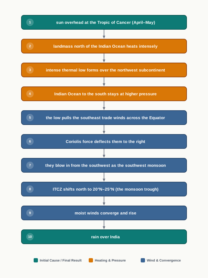
Fig. 4.1 – Onset of the southwest monsoon.
The exact timing of the burst is set higher up, by fast, narrow ribbons of high-altitude wind called jet streams. Through winter a westerly jet stream sits over the north Indian plain, just south of the Himalayas, and while it holds that position the monsoon is kept back. Only after this westerly jet withdraws does an easterly jet stream set in along about 15°N — and it is this easterly jet that is held responsible for the sudden burst of the monsoon over India. Fig. 4.2 shows that arrival, as the first rain-bearing clouds reach the land.
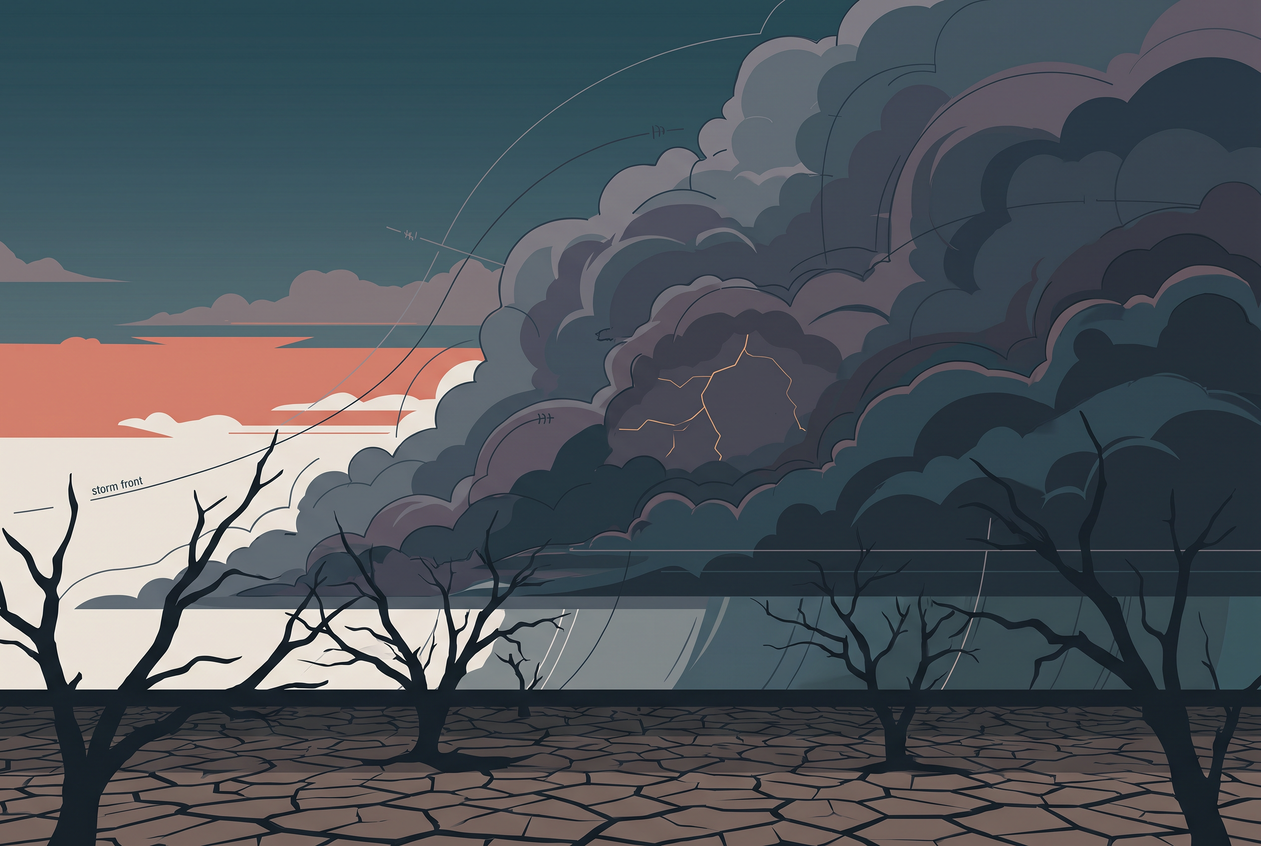
Fig. 4.2 – Arrival of monsoon clouds.
Entry Of Monsoon Into India
Once it bursts, the monsoon spreads fast. The southwest monsoon sets in over the Kerala coast, in the far southwest, by 1st June. It then moves swiftly northward to reach Mumbai on the west coast and Kolkata in the east between the 10th and 13th of June. By the middle of July it has engulfed the entire subcontinent (Fig. 4.3).
Map
Fig. 4.3 Caption: India: normal dates of onset of the southwest monsoon. Brief: Reproduce the NCERT map of India, showing the full extent of India as officially defined. Draw the isochrones — the lines joining places where the monsoon normally arrives on the same date — advancing from the far south and the Bay of Bengal (1 June) progressively across to the northwest (15 July). Label the dated lines (1 June, 5 June, 10 June, 15 June, 1 July, 15 July) and the cities marked. Keep the scale bar, north arrow and Tropic of Cancer as printed.
4.4.2 Break In The Monsoon
Even after it has arrived, the monsoon does not rain every day. During the southwest monsoon period, after a spell of rain, the rain may fail for a week or more. This dry gap in the middle of the rainy season is called a break in the monsoon, and such spells are quite common.
Breaks happen for different reasons in different regions. Over northern India, the rains tend to fail when the rain-bearing storms do not move often enough along the monsoon trough or the ITCZ. Over the west coast, the dry spells set in on days when the winds happen to blow parallel to the coast rather than striking it head-on — so the moist air is not forced upward, and little rain falls.
4.5 The Rhythm Of Seasons
The climate of India is best understood as an annual cycle of seasons that returns year after year. Meteorologists — scientists who study the weather — recognise four seasons in this cycle: the cold weather season, the hot weather season, the southwest monsoon season and the retreating monsoon season. The first two are described here; the two monsoon seasons follow in the sections after.
4.5.1 The Cold Weather Season
Winter Temperature
The cold weather season usually sets in by mid-November in northern India, and December and January are the coldest months on the northern plain. Across most of northern India the mean daily temperature stays below 21°C, and the night temperature can fall very low — sometimes below freezing point in Punjab and Rajasthan.
Three reasons together explain the sharp cold of north India in this season. First, states like Punjab, Haryana and Rajasthan lie far from the moderating influence of the sea, and so have a continental climate — the climate of deep interiors, which runs to extremes. Second, snowfall in the nearby Himalayan ranges chills the air and creates cold-wave conditions. Third, around February, cold winds arriving from the Caspian Sea and Turkmenistan, in central Asia, bring cold waves with frost and fog over the northwestern parts of India.
The Peninsular south is a different story: it has no well-defined cold weather season at all. Along its coasts there is hardly any seasonal change in temperature, because the sea moderates the climate and the region lies close to the equator. Thiruvananthapuram, on the Kerala coast, shows this clearly — its mean maximum temperature is 21°C in January and 29.5°C in June, barely any gap. The hills of the Western Ghats stay comparatively cool.
An annual range of only about 8.5°C is tiny. It is why the deep south feels almost the same in ‘winter’ as in summer, and why it has no real cold season: the surrounding ocean, warming and cooling slowly, holds the temperature nearly steady all year. Compare that with the interior north, where the gap between summer and winter runs to tens of degrees.
Winter Pressure And Winds
By the end of December, on the 22nd, the sun shines vertically over the Tropic of Capricorn, the line at about 23½°S in the southern hemisphere. With the sun gone south, the northern plain cools and comes under feeble high pressure, while the air pressure in south India is slightly lower. This is read off the isobars — lines joining places of equal air pressure — with the 1019 mb line running through northwest India and the 1013 mb line through the far south. A millibar, mb, is simply the unit in which air pressure is measured.
Because pressure is higher in the northwest and lower over the ocean to the south, winds begin to blow outward from the northwestern high towards the low over the Indian Ocean. The pressure gradient — the rate at which pressure changes from place to place — is gentle, so these winds are light, only about 3–5 km per hour. Their direction is shaped by the lie of the land: westerly or northwesterly down the Ganga valley, northerly in the Ganga-Brahmaputra delta, and clearly northeasterly once out over the Bay of Bengal, free of the land’s influence.
Winter weather in India is generally pleasant. From time to time, though, it is disturbed by shallow cyclonic depressions that form over the eastern Mediterranean Sea and travel eastward across West Asia, Iran, Afghanistan and Pakistan before reaching the northwest of India. On the way they gather extra moisture from the Caspian Sea in the north and the Persian Gulf in the south. What role do the westerly jet streams play in steering these depressions towards India? It is a question worth holding as you read on.
Winter Rainfall
The winter winds do not usually bring rain, because they blow from land to sea. They carry little moisture, and the anticyclonic circulation over the land — air spiralling outward from a high — further reduces the chance of rain. So most of India stays dry in winter. There are, however, some exceptions.
In the northwest, weak temperate cyclones — mild low-pressure systems from the middle latitudes — arrive from the Mediterranean Sea and bring rain to Punjab, Haryana, Delhi and western Uttar Pradesh. The amount is meagre, but it is highly beneficial for rabi crops, the winter-sown crops such as wheat. In the lower Himalayas this precipitation falls as snow, and it is this snow that later sustains the flow of the Himalayan rivers through the summer. The winter rain thins from west to east across the plains, and from north to south in the mountains: Delhi averages about 53 mm, while Punjab and Bihar get about 25 mm and 18 mm respectively.
Three further exceptions round out the winter rainfall. The central parts of India and the northern parts of the southern Peninsula get occasional winter rain. Arunachal Pradesh and Assam, in the northeast, receive between 25 mm and 50 mm during these winter months. And in October and November the northeast monsoon, crossing the Bay of Bengal, picks up moisture and brings torrential rain to the Tamil Nadu coast, southern Andhra Pradesh, southeast Karnataka and southeast Kerala.
4.5.2 The Hot Weather Season
Summer Temperature
As the sun appears to move north towards the Tropic of Cancer in March, temperatures begin to climb in north India, and April, May and June are the summer months there. Across most of India the temperatures recorded lie between 30°C and 32°C. In March the highest day temperature, about 38°C, occurs on the Deccan Plateau, the plateau of the southern peninsula; in April, Gujarat and Madhya Pradesh see 38°C to 43°C; and by May the heat belt has shifted north, so that in the northwest, temperatures around 48°C are not uncommon.
South India’s summer is milder. Its peninsular position, ringed by ocean, keeps temperatures lower than in the north — generally between 26°C and 32°C, and below 25°C in the hills of the Western Ghats because of their altitude. Along the coasts the isotherms — lines joining places of equal temperature — run parallel to the shore. This tells us something important: here temperature does not fall from north to south but rises from the coast inland. Even the mean daily minimum in summer stays high, rarely dropping below 26°C.
Summer Pressure And Winds
Summer is a time of fierce heat and falling air pressure over the northern half of the country. As the subcontinent heats, the ITCZ moves north to a position centred at about 25°N in July. This long, low monsoon trough stretches from the Thar desert in the northwest to Patna and the Chotanagpur plateau in the east and southeast. The trough draws in a surface circulation of winds — southwesterly along the west coast and along the coast of West Bengal and Bangladesh, and easterly or southeasterly over north Bengal and Bihar. As noted earlier, these southwesterly monsoon currents are really ‘displaced’ equatorial easterlies, and their arrival by mid-June turns the weather towards the rainy season.
In the heart of the trough in the northwest, hot, dry, oppressive winds called the ‘Loo’ blow through the afternoon and often on into midnight. Evening dust storms are common in May across Punjab, Haryana, eastern Rajasthan and Uttar Pradesh; these brief storms are a relief from the heat, bringing light rain and a cool breeze. Sometimes moist winds are pulled towards the edge of the trough, and where dry and moist air masses meet suddenly, they touch off violent local storms with fierce winds, torrential rain and even hail.
These hot-season storms carry local names. Towards the end of summer, pre-monsoon showers in Kerala and coastal Karnataka are called mango showers, because they help the mangoes ripen early. A related shower is the blossom shower, which makes the coffee flowers blossom in Kerala and nearby areas. In Bengal and Assam the dreaded evening thunderstorms are the Nor Westers, known locally as ‘Kalbaisakhi’ — a calamity of the month of Baisakh; harsh as they are, they help tea, jute and rice, and in Assam they are called ‘Bardoisila’. And the Loo itself blows across the northern plains from Punjab to Bihar, at its fiercest between Delhi and Patna.
4.6 The Southwest Monsoon Season
By May the northwestern plains have heated so fast that the low pressure over them deepens sharply. By early June this low is strong enough to pull in the trade winds of the southern hemisphere, blowing up from the Indian Ocean. These southeast trade winds cross the Equator and enter the Bay of Bengal and the Arabian Sea, where they are caught up in the circulation over India. Crossing the warm equatorial currents on the way, they take up moisture in abundance, and after crossing the Equator they swing to a southwesterly direction — which is why they are called the southwest monsoon.
The rain arrives abruptly. The first downpour brings the temperature down sharply, and this sudden onset of moisture-laden winds, with violent thunder and lightning, is what we call the ‘burst’ of the monsoon. The monsoon may burst in the first week of June along the coasts of Kerala, Karnataka, Goa and Maharashtra, while in the interior it can be delayed to the first week of July. Between mid-June and mid-July the day temperature falls by 5°C to 8°C.
As the winds reach land, their southwesterly path is bent by the relief and by the thermal low over northwest India, and the monsoon splits into two great branches: the Arabian Sea branch and the Bay of Bengal branch.
4.6.1 Monsoon Winds Of The Arabian Sea
The Arabian Sea branch itself divides into three.
The first sub-branch is stopped by the Western Ghats, the range along the west coast, also called the Sahyadris. Forced to climb their slopes from about 900 to 1200 m, the winds cool, and the windward side — the Sahyadris and the Western Coastal Plain, the narrow strip between the Ghats and the sea — receives very heavy rain, between 250 cm and 400 cm. Having crossed the crest, the winds descend the far side and warm again; as they warm, their humidity drops, and they bring little rain to the land east of the Ghats. This dry belt in the lee of the mountains is the rain-shadow area.
You can test this for yourself. Look up the rainfall at Kozhikode and Mangalore, on the windward coast, and at Pune and Bengaluru, inland behind the Ghats, and note the difference: the two coastal towns, catching the climbing winds, receive far more than the two sitting in the rain-shadow.
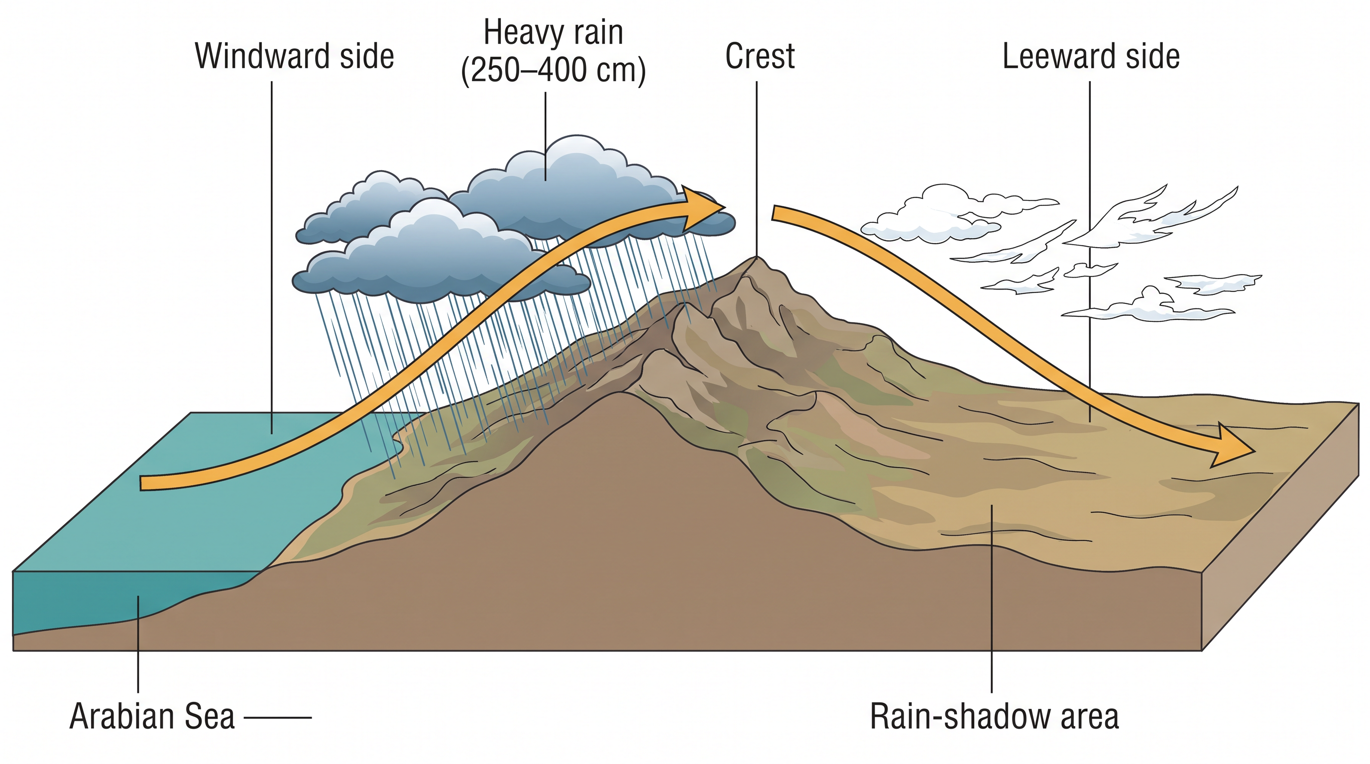
Fig. 4.4 – Rain-shadow effect of the Western Ghats.
The second sub-branch strikes the coast north of Mumbai. Running inland along the Narmada and Tapi river valleys — two west-flowing valleys of central India — it brings rain across large parts of central India; the Chotanagpur plateau in the east receives 15 cm from it, before the winds enter the Ganga plains and merge with the Bay of Bengal branch.
The third sub-branch hits the Saurashtra Peninsula and Kachchh, in Gujarat in the west, then passes over west Rajasthan and along the Aravalis — the old, worn hill range of Rajasthan — giving only scanty rain. Over Punjab and Haryana it too joins the Bay of Bengal branch, and together, reinforcing each other, they bring rain to the western Himalayas.
4.6.2 Monsoon Winds Of The Bay Of Bengal
The Bay of Bengal branch first strikes the coast of Myanmar and part of southeast Bangladesh. There the Arakan Hills, running along the Myanmar coast, deflect a large part of it towards the subcontinent, so that the monsoon enters West Bengal and Bangladesh from the south and southeast rather than from the southwest.
From there the branch splits in two, guided by the Himalayas and the thermal low over northwest India. One arm moves westward along the Ganga plains, reaching as far as the Punjab plains. The other arm moves up the Brahmaputra valley into the north and northeast, bringing widespread rain; a sub-branch of it strikes the Garo and Khasi hills of Meghalaya, and Mawsynram, on the crest of the Khasi hills, records the highest average annual rainfall in the world.
It is worth asking why the Tamil Nadu coast stays dry through this very season, while the rest of the country is being drenched. Two things put it out of reach of the rain. It lies parallel to the Bay of Bengal branch, so those winds run alongside it rather than striking it; and it sits in the rain-shadow of the Arabian Sea branch, cut off by the Western Ghats. Both branches, in effect, pass it by.
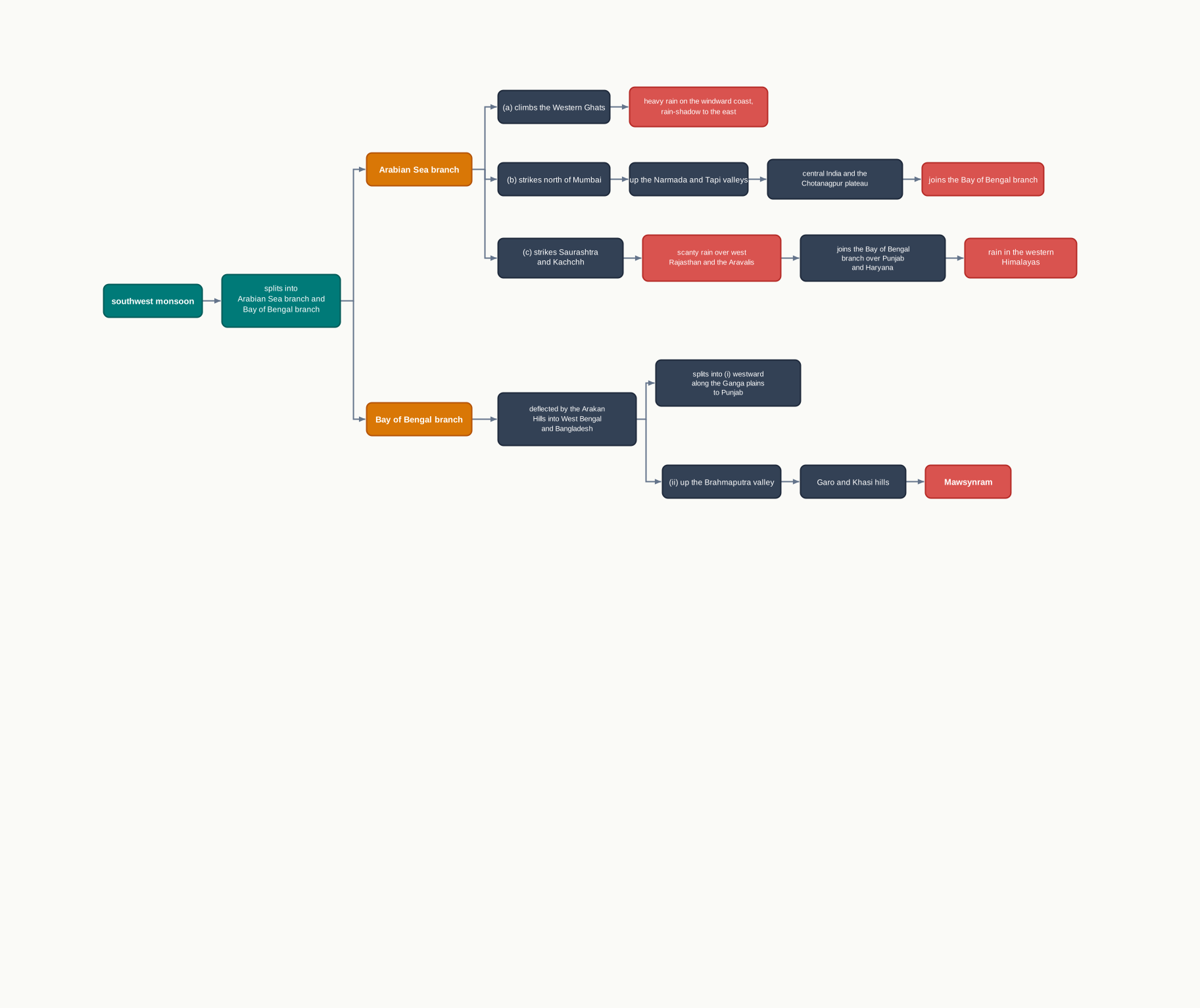
Fig. 4.5 – Branches of the southwest monsoon.
Put together, the two branches lay down the pattern of rain shown in Fig. 4.6.
Map
Fig. 4.6 Caption: India: seasonal rainfall, June to September. Brief: Reproduce the NCERT choropleth map of India, showing the full extent of India as officially defined. Shade the rainfall classes exactly as printed — above 400, 200–400, 100–200, 60–100, 40–60, 20–40, and 0–20 cm — and keep the key, scale bar, north arrow and Tropic of Cancer. Do not alter the class boundaries or values.
4.6.3 Season Of Retreating Monsoon
October and November are the months of the retreating monsoon — the season in which the southwest monsoon withdraws. By the end of September the low-pressure trough over the Ganga plain weakens and starts sliding south, following the sun. The monsoon retreats from western Rajasthan in the first week of September, withdraws from Rajasthan, Gujarat, the western Ganga plain and the Central Highlands of central India by the end of the month, covers the northern Bay of Bengal by early October, moves over Karnataka and Tamil Nadu by early November, and is gone from the Peninsula by mid-December.
This retreating season brings clear skies and rising temperature, but the land is still moist. The mix of heat and humidity makes the weather oppressive — the ‘October heat’. In the second half of October the mercury starts to fall quickly, especially in the north. The retreating monsoon is dry over north India, but in the eastern Peninsula it is the opposite: here October and November are the rainiest months of the year.
That rain comes with tropical cyclones — intense, whirling low-pressure storms — and cyclonic depressions that form over the Andaman Sea and cross the eastern coast of the southern Peninsula. They are very destructive. Their preferred targets are the thickly populated deltas — the fan-shaped mouths where a river meets the sea — of the Godavari, Krishna and Kaveri, where every year cyclones bring disaster. A few also strike the coasts of West Bengal, Bangladesh and Myanmar. Much of the rain of the Coromandal coast comes from these storms, which are far less frequent in the Arabian Sea.
4.7 Traditional Indian Seasons
Long before meteorologists drew up their four seasons, Indian tradition divided the year into six two-monthly seasons. This older calendar, still followed by common people across north and central India, grew out of practical experience and a long, careful reading of the weather. It does not fit the south, though, where the seasons vary little through the year. The six seasons, and the months they cover, are set out in Table 4.1.
4.7.1 Distribution Of Rainfall
The average annual rainfall over India is about 125 cm — but that single figure hides enormous variation from place to place. It helps to sort the country into four rainfall belts, from the wettest to the driest.
The wettest belt, with more than 200 cm a year, runs along the west coast on the Western Ghats, and across the sub-Himalayan northeast and the hills of Meghalaya. In parts of the Khasi and Jaintia hills the rainfall passes 1,000 cm, though in the Brahmaputra valley and its adjoining hills it stays below 200 cm.
A belt of medium rainfall, between 100 and 200 cm, takes in southern Gujarat, east Tamil Nadu, and a broad northeastern stretch of the Peninsula — Odisha, Jharkhand, Bihar and eastern Madhya Pradesh — together with the northern Ganga plain along the sub-Himalayas, the Cachar Valley and Manipur.
Lower still, between 50 and 100 cm, lie western Uttar Pradesh, Delhi, Haryana, Punjab, Jammu and Kashmir, eastern Rajasthan, Gujarat and the Deccan Plateau.
The driest areas of all, below 50 cm, are parts of the Peninsula — especially Andhra Pradesh, Karnataka and Maharashtra — along with Ladakh and most of western Rajasthan. Snowfall, meanwhile, is confined to the Himalayan region. Trace these belts for yourself on the annual rainfall map, Fig. 4.7, and the reach of the monsoon becomes clear at a glance.
Map
Fig. 4.7 Caption: India: annual rainfall. Brief: Reproduce the NCERT choropleth map of India, showing the full extent of India as officially defined. Shade the four rainfall classes exactly as printed — more than 200, 100–200, 50–100, and less than 50 cm — and keep the key, scale bar, north arrow and Tropic of Cancer. Do not alter the class boundaries or values.
4.7.2 Monsoons And The Economic Life In India
The monsoon is the axis around which the whole agricultural cycle of India turns. About 64 per cent of India’s people depend on agriculture for their livelihood, and that agriculture rests on the southwest monsoon. Outside the Himalayas, every part of the country stays warm enough — above the temperature threshold that crops need — to grow plants right through the year, and the regional differences in the monsoon climate allow many different crops to be grown across the country.
But dependence on the monsoon cuts both ways. The variability of the rainfall — its habit of arriving early or late, heavy or thin — brings drought to some parts of the country and floods to others, every single year. Agricultural prosperity therefore hangs on rain that is both timely and well spread. Where the rain fails, farming suffers most in exactly those regions where irrigation — the artificial supply of water to crops — is least developed. The sudden burst of the monsoon brings harm of its own, stripping topsoil through soil erosion over large areas.
Not all of the monsoon’s gifts come in summer. The winter rain brought by temperate cyclones in the north is highly valuable for the rabi crops. And beyond farming, the sheer regional variety of India’s climate shows up in the vast range of its food, its clothing and its house types — each shaped to the weather of its own place.
4.8 Global Warming
Change is the law of nature, and climate is no exception. The Earth’s climate has changed many times in the past, both globally and locally, and it is changing even now — only so slowly that the change is imperceptible from one year to the next. Geological evidence shows that once, long ago, a large part of the Earth lay under ice. Today the concern is the opposite: the debate over global warming, the steady rise in the world’s temperature. Its causes are partly natural, but human activities — large-scale industrialisation and the polluting gases it releases into the atmosphere — are important causes too. At the centre of the discussion is the greenhouse effect: the trapping of heat by certain gases in the air, which keeps the planet warmer than it would otherwise be.
The world’s temperature is rising significantly. The chief worry is carbon dioxide, produced in huge amounts when fossil fuels — coal, oil and natural gas — are burned, and building up gradually in the atmosphere. Other gases are present in far smaller amounts: methane, chlorofluorocarbons and nitrous oxide. Together with carbon dioxide, these are called greenhouse gases, because they absorb long-wave radiation — the heat given off by the warmed Earth — and hold it within the atmosphere. Molecule for molecule, these other gases are actually better absorbers of long-wave radiation than carbon dioxide, so they enhance the greenhouse effect even more strongly. As they build up, the planet warms; and it is said that this warming would melt the polar ice caps and mountain glaciers, raising the amount of water in the oceans.
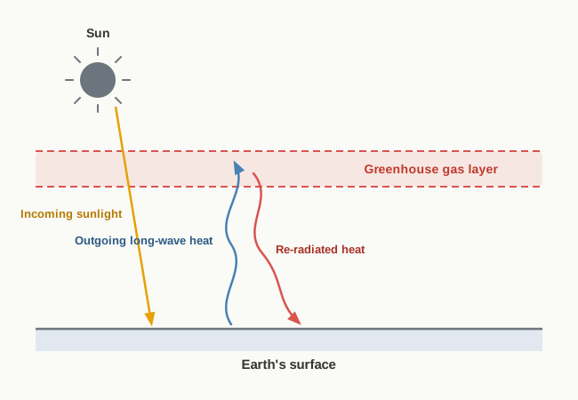
Fig. 4.8 – The greenhouse effect.
The mean annual surface temperature of the Earth has risen over the past 150 years, and it is projected that by the year 2100 the global temperature will be about 2°C higher. Such a rise would set off many further changes. One is a rise in sea level, as glaciers and sea-ice melt: current predictions put the average rise at about 48 cm by the end of the twenty-first century, which would make yearly flooding more common. Warming could also spread insect-borne diseases such as malaria, and shift climatic boundaries — leaving some regions wetter and others drier. As the climate shifts, farming patterns, human populations and whole ecosystems would have to change with it. What would happen to the Indian sea coasts if the sea level rose 50 cm above where it stands today?
4.9 Summary
- Weather is the momentary state of the atmosphere; climate is its long-term average. The monsoon is a climate built on the seasonal reversal of winds, and India has a hot monsoonal climate.
- Beneath one broad monsoon climate lie many regional sub-types. Temperature varies from place to place, from day to night (the diurnal range) and from season to season (the annual range); rainfall varies in type, in amount and in timing.
- Six factors together control India’s climate: latitude, the Himalayan wall, the distribution of land and water, distance from the sea, altitude and relief.
- The monsoon’s onset begins with intense summer heating. A thermal low over the northwest pulls the southeast trades across the Equator, the Coriolis force bends them into the southwest monsoon, and the ITCZ shifts north as the monsoon trough; the jet streams time the sudden burst.
- The southwest monsoon reaches the Kerala coast by 1 June and covers the whole country by mid-July. Dry gaps within the rainy season are called breaks.
- Meteorologists count four seasons: the cold weather season, the hot weather season, the southwest monsoon season and the retreating monsoon season.
- In winter, high pressure sends dry winds out from the land; the north turns cold while the peninsular south stays mild. In summer, fierce heat deepens the low, and the Loo and violent local storms sweep the northern plains.
- The southwest monsoon arrives in two branches. The Arabian Sea branch drenches the windward Western Ghats and leaves a rain-shadow to the east; the Bay of Bengal branch is funnelled into the Meghalaya hills, where Mawsynram is the wettest place on Earth.
- The Tamil Nadu coast stays dry in the main season but takes its heaviest rain from the retreating monsoon and its cyclones in October and November.
- India’s average annual rainfall is about 125 cm, but it is spread very unevenly across four rainfall belts. The monsoon is the axis of India’s agriculture, and its variability brings both drought and flood.
- Climate itself changes over time. Global warming, driven partly by human greenhouse-gas emissions, is projected to raise temperatures and sea levels through this century.

Fig. 4.9 – The annual cycle of the monsoon.
What This Chapter Cannot Tell You
- A national average hides everything inside it: the figure of 125 cm sits between Mawsynram’s thousands of centimetres and the desert’s handful, and describes no real place on its own.
- The rainfall maps give totals for a season or for the year; they cannot show when within that time the rain actually fell, or how far a single year strayed from the normal.
- The monsoon still puzzles science — no single theory explains it fully — and the projections for future warming are models resting on assumptions, not certainties.
4.10 NCERT Questions
What causes rainfall on the coastal areas of Tamil Nadu in the beginning of winters?
- South-West monsoon
- Temperate cyclones
- North-Eastern monsoon
- Local air circulation
What is the proportion of area of India which receives annual rainfall less than 75 cm?
- Half
- One-third
- Two-third
- Three-fourth
Which one of the following is not a fact regarding South India?
- Diurnal range of temperature is less here.
- Annual range of temperature is less here.
- Temperatures here are high throughout the year.
- Extreme climatic conditions are found here.
Which one of the following phenomenon happens when the sun shines vertically over the Tropic of Capricorn in the southern hemisphere?
- High pressure develops over North-western India due to low temperatures.
- Low pressure develops over North-western India due to high temperatures.
- No changes in temperature and pressure occur in north-western India.
- ‘Loo’ blows in the North-western India.
What is the Inter-Tropical Convergence Zone? (about 30 words)
What is meant by ‘bursting of monsoon’? Name the place of India which gets the highest rainfall. (about 30 words)
Which type(s) of cyclones cause rainfall in north-western India during winter? Where do they originate? (about 30 words)
Notwithstanding the broad climatic unity, the climate of India has many regional variations. Elaborate this statement giving suitable examples. (not more than 125 words)
How many distinct seasons are found in India as per the Indian Meteorological Department? Discuss the weather conditions associated with any one season in detail. (not more than 125 words)
On the outline map of India, show the following:
- Areas of winter rain
- Wind direction during the summer season
- Areas having less than 15°C temperature in January
- Isohyet of 100 cm.
4.11 Check Your Concepts
Using Fig. 4.3, describe the direction in which the southwest monsoon advances across India, and name the part of the country it reaches last.
In January, Agra records 16°C and Darjiling 4°C, though the two towns lie at almost the same latitude. How many degrees colder is Darjiling, and which single factor explains the difference?
Give the two reasons the chapter offers for why the Tamil Nadu coast stays dry during the southwest monsoon season.
Explain how the meagre winter rainfall of the northwest, though small in amount, helps keep the Himalayan rivers flowing through the following summer.
Contrast the way the Arabian Sea branch and the Bay of Bengal branch of the southwest monsoon reach India, and say where each brings its heaviest rain.
Reconstruct, step by step and in order, the chain of events that brings the southwest monsoon to India, from the summer heating of the land to the first burst of rain.
The average annual rainfall of India is about 125 cm. Using places named in the chapter, explain why this single figure gives a misleading picture of how rainfall is actually distributed.