Chapter 3: Latitude, Longitude And Time
Picture a flight leaving Auckland, in New Zealand, late on a Tuesday evening and heading east across the wide Pacific towards Los Angeles, on the western coast of the United States. The cabin lights dim, most passengers sleep, and the plane crosses thousands of kilometres of dark ocean. Yet when it lands, the calendar has done something strange. The passengers step off into a Tuesday morning — earlier in the very day they thought they had left behind. By the clock they have flown for hours into the future; by the date they have travelled back into yesterday.
No trick was played. Somewhere over the empty ocean the aircraft crossed a single imaginary line, and on the far side of it the name of the day changed. Sail west across that same line and the opposite happens: a day vanishes, and Tuesday becomes Wednesday in one step.
This is not magic but geometry. The earth is a spinning sphere, turning steadily from west to east, and the sun can light only one half of it at a time. Because the planet is round, no single clock can serve everyone: when it is noon in one place, it is midnight on the far side. To pin down where a place sits, and what time it keeps, geographers lay a web of imaginary lines over the globe. This chapter shows how those lines are drawn, and how they turn the turning of the earth into the time on your wrist.
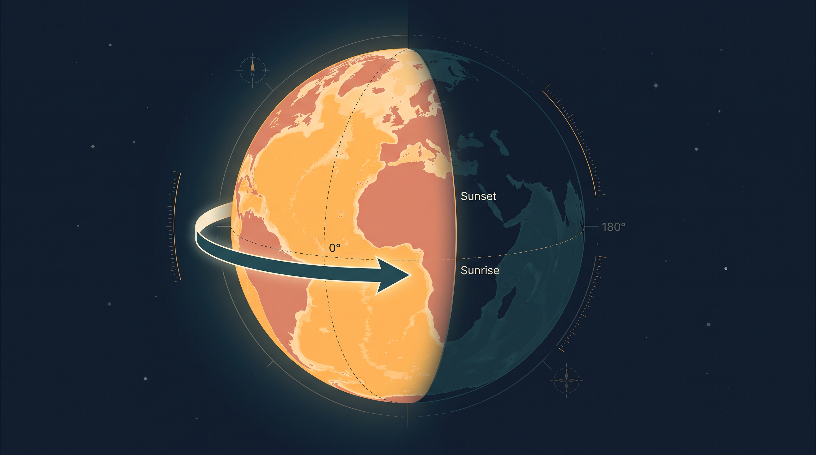
Fig. 3.0 – The day–night boundary sweeping across meridians.
3.1 The Geographical Grid
The Shape We Map
The earth is very nearly a sphere, but not quite. Its equatorial radius — the distance from the centre out to the equator — is a little greater than its polar radius, the distance from the centre to either pole. The reason lies in the earth’s own spin. As the planet turns on its axis, the material near the equator is thrown very slightly outward, so the globe bulges around its middle and is flattened at the top and bottom. This gently squashed shape is called an oblate spheroid — a sphere pressed in a little at the poles and swollen at the equator.
That shape creates a practical problem. On a smooth ball there is no corner, no edge, no fixed landmark to measure from. To say where a place lies, we need something to measure against. So geographers draw a network of imaginary lines over the globe or the map, and use them to fix the position of every feature.
Two Natural Reference Points
The spin that flattens the earth also gives us our starting points. Because the planet turns steadily from west to east, its axis meets the surface at two fixed spots — the North Pole and the South Pole. These two points are given by nature, not chosen by us, and the entire system of lines is built outward from them. Together, that system is the geographical grid: a mesh of intersecting lines drawn for the single purpose of fixing locations.
The grid is made of two families of lines. One set runs across, east to west; the other runs up and down, north to south. The east–west set are the parallels of latitude, and the north–south set are the meridians of longitude. Fig. 3.1 shows the two families woven into a single grid.
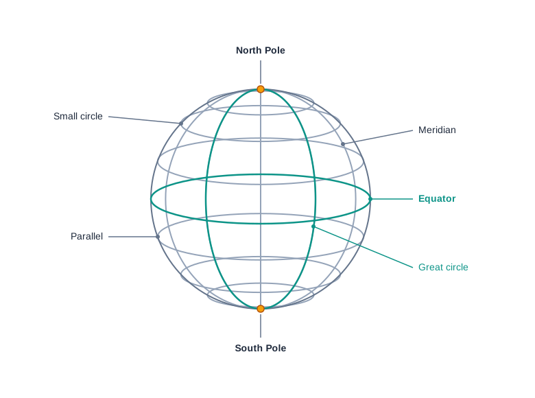
Fig. 3.1 – The geographical grid.
Lines That Run East–West
The horizontal lines are drawn parallel to one another, running east to west. The most important of them is the line drawn exactly midway between the two poles: the equator. The equator is the largest circle that can be drawn on the globe, and it splits the earth into two equal halves. Because it cuts the sphere into two equal parts, it is called a great circle.
Every other parallel is smaller than the equator. As you move away from the equator towards either pole, the parallels shrink, and each one divides the earth into two unequal halves. These smaller parallels are called small circles. So among the parallels the equator stands alone as the one great circle; all the rest are small circles, growing tinier the closer they lie to a pole.
Lines That Run North–South
The vertical lines run north to south and join the two poles. These are the meridians of longitude. Unlike the parallels, they do not stay the same distance apart. They are spaced farthest apart where they cross the equator, and they draw closer and closer together as they climb towards a pole, until they all meet at a single point at each pole.
Where a parallel and a meridian cross, they mark one exact spot. Read together, the two lines give a place its geographical coordinates — the pair of values that pins it down. With a place’s coordinates in hand, its location, its distance from other places, and its direction from them can all be worked out.
Measuring In Degrees
An endless number of parallels and meridians could be drawn on a globe, but a map shows only a selected few. The lines are measured in degrees (°), because latitude and longitude are angular distances — angles measured at the centre of the earth, not lengths paced out along the ground. To measure finely, each degree is split into 60 minutes (’), and each minute into 60 seconds (“). A position can therefore be given as precisely as the task needs, right down to seconds of arc.
3.2 Parallels Of Latitudes
What Latitude Measures
The latitude of a place is its distance north or south of the equator. It is not paced out in kilometres along the ground but measured as an angle, taken at the centre of the earth and read along the meridian that runs through the place. The lines joining all the places that share the same latitude are the parallels.
The equator is the reference from which every latitude is counted, so its value is 0°. From there the angle grows northward and southward until it reaches the poles, which stand at 90°N and 90°S. Because a latitude value alone does not say which side of the equator a place lies on, the letter N or S is written after it — 20°N and 20°S are two different parallels, one in each hemisphere. Fig. 3.2 shows the parallels stacked from the equator up to the pole.
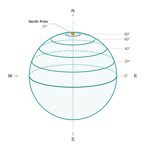
Fig. 3.2 – Parallels of latitudes.
How Many Parallels?
Suppose we draw a parallel at every whole degree. In the northern hemisphere that gives one line at each degree from 1° up to 89°, which is 89 parallels; the southern hemisphere gives another 89. The pole itself, at 90°, is a single point rather than a circle, so it is not counted as a parallel. Adding the two hemispheres and the equator that lies between them, 89 + 89 + 1 = 179 parallels in all. Finer spacing would give many more — an infinite number, in principle — but at one-degree intervals the count is 179.
The Length Of A Degree
If the earth were a perfect sphere, one degree of latitude — a one-degree arc measured along a meridian — would be the same length everywhere, about 111 km. That figure is almost the same as the length of one degree of longitude at the equator. But the earth is not a perfect sphere; it is the oblate spheroid of the previous section, flattened towards the poles.
That flattening shifts the arc very slightly. Where the surface curves gently, near the poles, a one-degree slice reaches a little farther across the ground than where the surface curves more sharply, near the equator. So a degree of latitude measures about 110.6 km at the equator and 111.7 km at the poles. The difference is small — barely a kilometre — but it is real, and it is the direct fingerprint of the earth’s squashed shape.
A place’s latitude can also be found from the sky, from the altitude of the sun or of the Pole Star above the horizon.
3.3 Drawing The Parallels Of Latitudes
Setting Up The Circle
To draw the parallels, picture the earth seen edge-on. Draw a circle to stand for the globe, then draw a horizontal line straight through its centre, dividing it into two equal halves. That centre line is the equator. Now lay a protractor on the circle so that its 0° and 180° marks rest exactly on the equator. The protractor’s baseline and the equator are now the same line — which matters, because every latitude is an angle measured up or down from the equator.
Turning An Angle Into A Line
Say we want the parallel for 20°S. Latitude is the angle from the equator, so measure 20° down from the equator — into the lower half of the circle — on both the east and the west sides, and mark a point at each. The two arms of the 20° angle meet the circle at these two points. Join them with a straight line drawn parallel to the equator, and that line is the parallel of 20°S. The same method draws any parallel: choose the degree, measure the angle from the equator on both sides, and join the points where the arms cut the circle. Fig. 3.3 shows the construction for 20°S, and Fig. 3.4 sets out the steps in order.
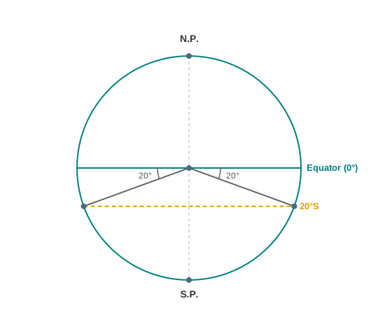
Fig. 3.3 – Drawing of parallels of latitudes.

Fig. 3.4 – Steps for drawing a parallel of latitude.
3.4 Meridians Of Longitude
Semi-Circles That Meet
The meridians of longitude behave quite differently from the parallels. A parallel is a complete circle, but a meridian is only a semi-circle, a half-loop running from the North Pole to the South Pole. Two opposite meridians, taken together, do close into a full circle — yet each is counted and valued as a separate meridian.
Meridians differ from parallels in two further ways. They cross the equator at right angles, and they are all exactly equal in length, whereas the parallels grow shorter towards the poles. But the meridians are not evenly spaced along their whole run: they stand farthest apart at the equator and converge until they meet at each pole. The east–west gap between two meridians is therefore widest at the equator, about 111.3 km, and closes to nothing at the poles (Table 3.1).
A Zero Chosen By Agreement
The parallels have a natural starting line: the equator, fixed by nature exactly midway between the poles. The meridians have no such natural zero — one pole-to-pole line is as good as any other. So a zero had to be chosen. By international agreement, and simply for convenience of numbering, the meridian passing through the Greenwich observatory, near London in England, was adopted as the Prime Meridian and given the value 0°.
From that agreed line the longitude of a place is measured: its angular distance east or west of the Prime Meridian, given in degrees. Longitudes run from 0° at Greenwich to 180° on the far side of the earth, counted both eastward and westward. The half of the earth east of the Prime Meridian is the eastern hemisphere, and the half to its west is the western hemisphere. Fig. 3.5 shows the meridians fanning out from Greenwich.
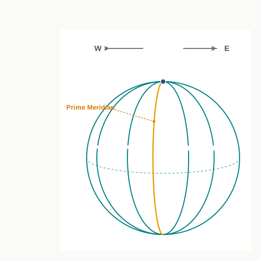
Fig. 3.5 – Meridians of longitude.
Comparing The Two Sets
Now that both families of lines have been described, Table 3.1 sets them side by side. It gathers the differences already met — circle versus semi-circle, varying versus equal length, natural versus agreed zero — and adds a few more, including the jobs each set does.
3.4.1 Drawing The Meridians Of Longitude
Looking Down The Pole
To draw the meridians, start with a circle whose centre stands for the North Pole; its circumference then stands for the equator. Draw a vertical line straight through the centre, crossing the North Pole. This single line represents the 0° and 180° meridians, which meet at the pole, as in Fig. 3.6.
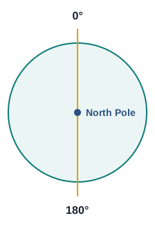
Fig. 3.6 – Meridians meeting at the North Pole.
There is a trap to watch here. On a wall map, east lies to your right and west to your left. But to draw longitude we imagine looking straight down on the earth from above the North Pole — from the centre of the circle. Seen from that overhead position the two directions swap: east now falls to your left and west to your right.
Marking Forty-Five Degrees
To draw 45°E and 45°W, place the protractor along the vertical line so it coincides with the 0° and 180° meridians, then measure 45° out on each side. The left-hand arm marks the 45°E meridian and the right-hand arm the 45°W meridian, as in Fig. 3.7. The finished drawing shows how the earth would appear if you looked at it from directly above the North Pole.
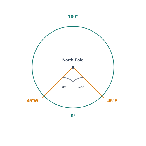
Fig. 3.7 – Drawing of meridians of longitude.
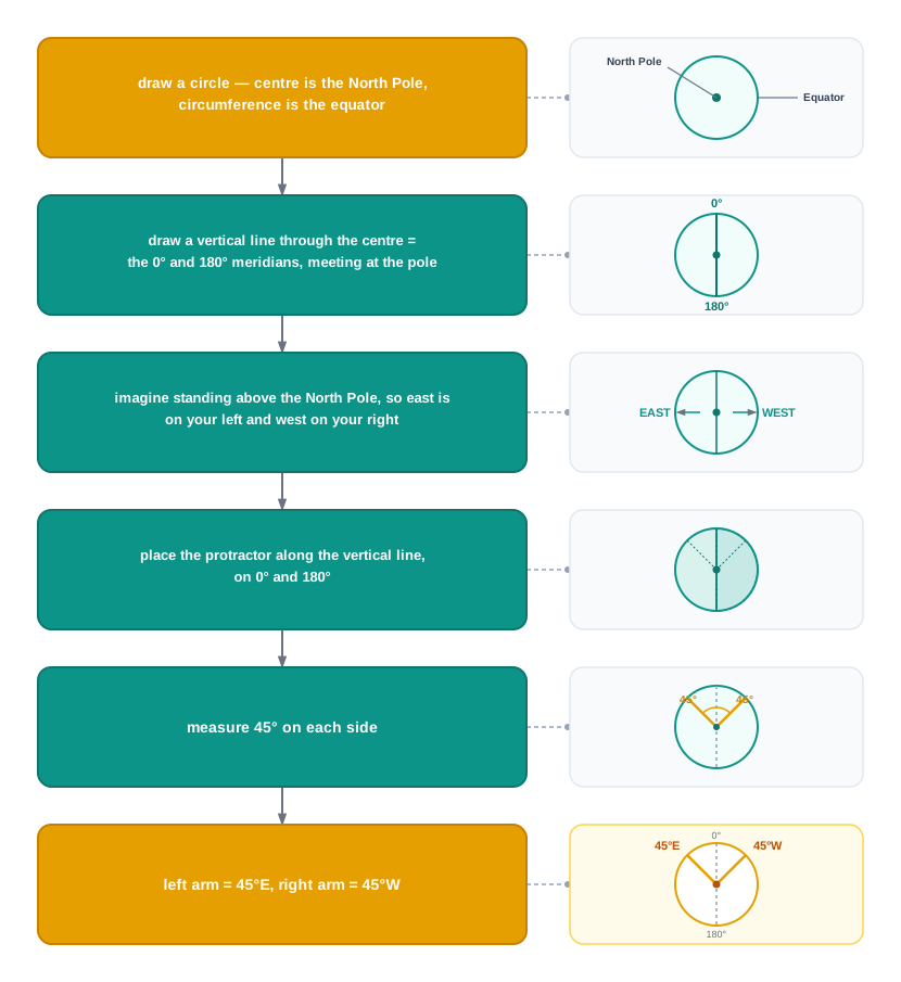
Fig. 3.8 – Steps for drawing the meridians of longitude.
3.5 Longitude And Time
The Sun’s Daily Sweep
The earth spins on its axis from west to east. That single fact is why the sun appears to rise in the east and set in the west: it is not the sun that travels across the sky, but the ground beneath us turning to meet it and then turning away.
One full turn — a complete 360° of longitude — takes 24 hours. Because 180° of longitude lie east of the Prime Meridian and 180° lie west, the sun appears to take 12 hours to cross each hemisphere. As it does so, it stands overhead at one meridian after another, so noon arrives at different meridians at different moments. This is why two places on different meridians keep different local times.
Fifteen Degrees An Hour
We can turn that daily sweep into an exact rate. In 24 hours the sun appears to move through all 360° of longitude, so in one hour it moves through
\[\frac{360^\circ}{24 \text{ hours}} = 15^\circ \text{ per hour}\]
An hour is 60 minutes, so the time taken to cross a single degree is
\[\frac{60 \text{ minutes}}{15^\circ} = 4 \text{ minutes per degree}\]
Every degree of longitude, then, is worth exactly four minutes of time. And because the earth turns west to east, a place to the east meets the sun sooner: as we move eastward from the Prime Meridian, local time runs ahead and clocks read a later hour; as we move westward, local time falls behind.
Reading Time From Longitude
This rate lets us find the local time of any place, once we know its longitude and the time at Greenwich. Fig. 3.9 lays out the method as a set of steps; the two cases below put it to work.
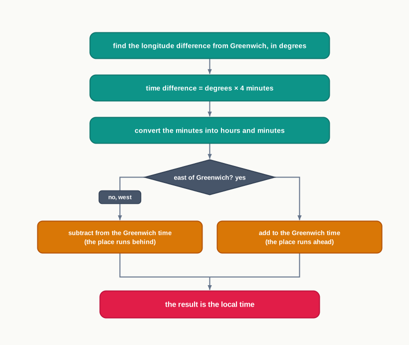
Fig. 3.9 – Calculating local time from longitude.
At the very instant Greenwich shows midday, Thimpu shows early evening. Nothing about time itself has changed; the sun simply passed over 90°E six hours before it reached Greenwich, so Thimpu’s day is that much further along.
Put the two cases together and the logic of longitude and time stands out. Thimpu and New Orleans both sit 90° from Greenwich, but on opposite sides — so at the same moment one reads 6.00 p.m. and the other 6.00 a.m., a full 12 hours apart. In just this way the local time of any place on earth can be worked out.
One Clock For A Country
If every town kept its own local time, a country would have as many clocks as it had meridians, and ordinary life would be chaos. To avoid this, a nation fixes on one meridian near its middle — its Standard Meridian — and makes that meridian’s local time the standard time for the whole territory. The Standard Meridian is usually chosen so that it divides evenly by 15° or by 7°30’, which makes the country’s offset from Greenwich a neat whole number of hours or half-hours.
India follows exactly this rule. Indian Standard Time is set by the 82°30’E meridian, which passes through Mirzapur in northern India. Working out the offset:
\[82^\circ 30' \times 4 \text{ minutes} = 330 \text{ minutes} = 5 \text{ hours } 30 \text{ minutes}\]
So the whole of India runs 5 hours 30 minutes ahead of Greenwich Mean Time, from its eastern edge to its western edge, on a single clock. Other countries choose a standard meridian within their own borders in the same way. A country that stretches a long way from east to west may need more than one — Russia, Canada and the United States of America each keep several time zones.
The World’s Time Zones
Taken together, these national choices divide the world into 24 major time zones, each roughly one hour apart. Fig. 3.10 shows them as vertical bands running across the whole world.
Map
Fig. 3.10 Caption: Major time zones of the world. Brief: Redraw NCERT’s world time-zone map; show the world’s landmasses with vertical time-zone bands, each labelled with its offset from Greenwich (…, −5, 0 at Greenwich, +5½ for India, … up to ±12); mark the Prime Meridian, the International Date Line near 180°, and the oceans; show India to its full official extent; keep the half-hour offsets (such as +5½) exactly as printed.
3.6 International Date Line
Where The Day Begins
The 24 time zones solve the problem of the hour, but they leave a deeper one untouched. If it is always a little earlier to the west and a little later to the east, then somewhere on the globe the calendar day itself must change — there has to be one line where today becomes yesterday, a place where each new day truly begins. That line runs, roughly, along the 180° meridian, and it is called the International Date Line.
The 180° meridian is special because it sits exactly 12 hours from Greenwich whichever way you travel. Go east from the Prime Meridian and you add hours until, at 180°, you are 12 hours ahead. Go west and you subtract hours until, at 180°, you are 12 hours behind. The two routes reach the same line but disagree by a full 24 hours — one whole day. The Date Line is where that one-day disagreement is settled.
Crossing The Line
Because the Date Line marks a jump of one day, crossing it means changing the date on your calendar, and the direction of travel decides which way the date jumps. Fig. 3.11 shows both cases.
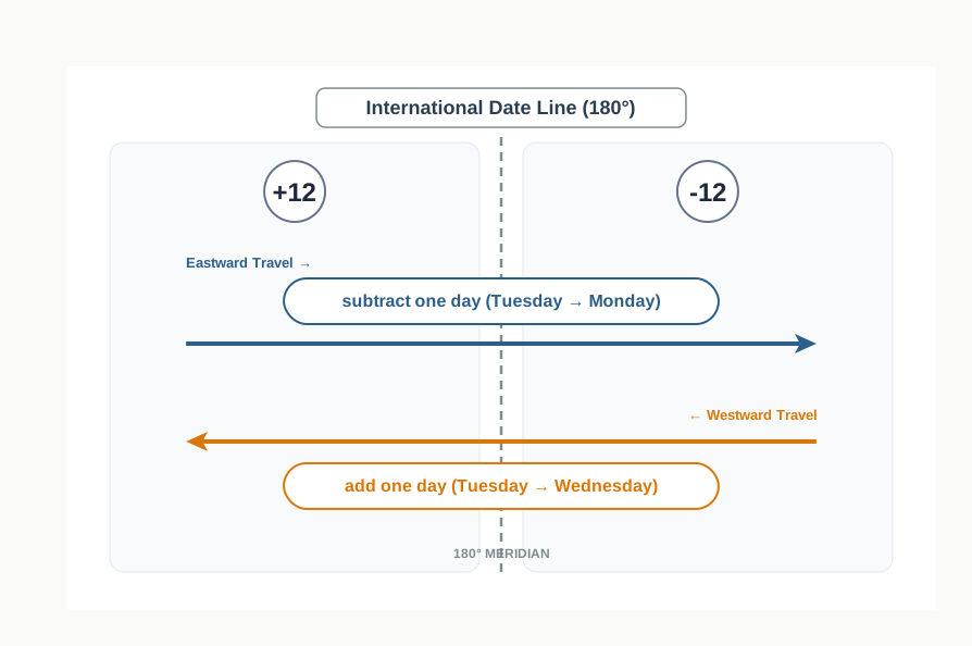
Fig. 3.11 – Crossing the International Date Line.
A traveller heading eastward across the line moves onto the side whose clock is behind, and so steps back a day: setting out on a Tuesday, they count the day as Monday once the line is crossed. A traveller heading westward does the opposite, moving onto the side whose clock is ahead, and so skips forward a day: leaving on the same Tuesday, they count the day as Wednesday after crossing. Same line, same moment, opposite jumps.
3.7 Summary
- The earth is an oblate spheroid — it bulges at the equator and is flattened at the poles — because it spins on its axis.
- To fix the position of places, a grid of imaginary lines is drawn on the globe: parallels of latitude running east–west, and meridians of longitude running north–south.
- The equator (0°) is a great circle drawn midway between the poles; the other parallels are smaller circles. Latitude is the angle a place lies north or south of the equator, running to 90°N and 90°S.
- One degree of latitude is about 111 km, changing slightly from 110.6 km at the equator to 111.7 km at the poles — the mark of the earth’s flattened shape.
- Meridians are equal semi-circles that converge at the poles. The Prime Meridian (0°), through Greenwich, is fixed by international agreement; longitude is the angle a place lies east or west of it, from 0° to 180°.
- Read together, latitude and longitude give a place’s geographical coordinates, from which its location, distance and direction can be found.
- The earth turns 360° in 24 hours, so the sun crosses 15° of longitude every hour, or one degree every 4 minutes; local time runs ahead to the east of a meridian and behind to its west.
- To keep a single time across a country, a Standard Meridian is chosen and its local time used everywhere; India’s is 82°30’E, which sets Indian Standard Time 5 hours 30 minutes ahead of Greenwich Mean Time.
- The world is divided into 24 major time zones, and at roughly the 180° meridian the International Date Line marks where the calendar day changes.
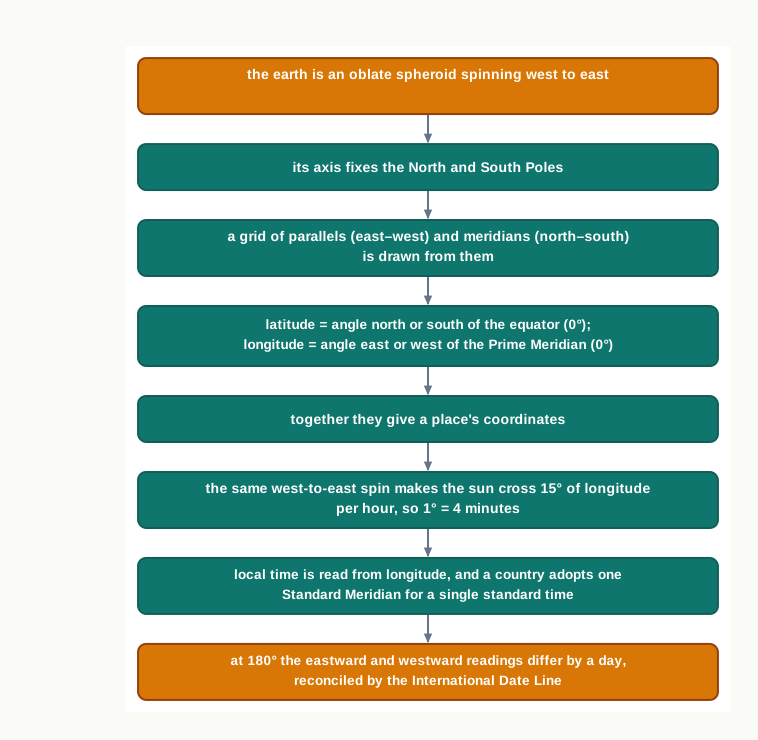
Fig. 3.12 – Chapter summary: the grid and time.
What This Chapter Cannot Tell You
The grid fixes exactly where a place is, but says nothing about what is there — the land, the water, the climate or the people at those coordinates. The 4-minutes-per-degree rule gives a meridian’s local solar time, not the official clock a place keeps, which countries round to whole hours or half-hours and hold across their whole width. And the Date Line is drawn here as a straight 180° meridian, whereas on the real map it bends around islands and nations, detours this neat rule cannot show.
3.8 NCERT Questions
Which are the two natural points of reference on the earth?
What is a great circle?
What are coordinates?
Why does the sun appear to be moving from east to west?
What is meant by local time?
Distinguish between latitudes and longitudes.
Find out the locations of the following places with the help of your atlas and write their latitudes and longitudes: Mumbai, Vladivostok, Cairo, New York, Ottawa, Geneva, Johannesburg and Sydney.
What would be the time of the following cities if the time at the Prime Meridian is 10 a.m.: Delhi, London, Tokyo, Paris, Cairo and Moscow?
3.9 Check Your Concepts
The equator divides the earth into two equal halves, but every other parallel divides it into two unequal halves. Which parallel is the great circle, and why are all the others called small circles?
Look at Table 3.1. The distance between two meridians of longitude is 111.3 km at the equator, 79 km at 45° of latitude and 0 km at the poles, while the distance between two parallels of latitude stays close to 111 km everywhere. Explain why the longitude distance shrinks towards the poles but the latitude distance does not.
The chapter says a place’s latitude can be found from the altitude of the Pole Star or the sun. Which measurement does the chapter link to finding a place’s longitude?
Set out, in order, the steps you would follow to draw the parallel of 20°S on a circle.
Using the rule of 4 minutes for every degree of longitude, work out how many minutes of time separate two places that lie 15° of longitude apart. Show each step of your working.
India’s Standard Meridian is 82°30’E. Show, step by step, how this gives Indian Standard Time as 5 hours 30 minutes ahead of Greenwich Mean Time.
Explain why a traveller crossing the International Date Line while heading eastward counts one day back, whereas a traveller heading westward counts one day forward.