Chapter 2: Establishment Of Indian Democracy (1947–1966)
In the last week of October 1951, polling parties walked up into the high valleys of Himachal Pradesh, in the western Himalaya. They carried sealed steel ballot boxes on their backs. They were not early. They were exactly on time, because by December the snow would close the passes, and a vote not taken before winter could not be taken at all.
So the first general election of independent India began in the mountains, weeks before most of the country voted. Polling was staggered across nearly four months, from 25 October 1951 to 21 February 1952. The electorate was the largest that had ever been asked to vote anywhere in the world, and most of those voters could not read the names printed on a ballot paper. Nobody had attempted this before, at this size, on these terms.
What makes it stranger is that the country doing it was four years old, and had spent those four years being assembled. In August 1947 the map of India was not one colour. Alongside the provinces the British had ruled directly lay hundreds of princely states, each with its own ruler, and each free in law to choose its own future. Three of them had not joined when the rest did.
We know the detail of all this — the dates, the routes, the boxes, the arguments — because the new state wrote itself down, in commission reports, accession documents, election returns and newspapers. This chapter is built out of that paper.
Map
Map 2.1 Caption: India in August 1947, showing the provinces of the Indian Dominion alongside the princely states that had still to decide their future. Brief: Political map of the subcontinent as it stood in August 1947. Shade directly ruled provinces of the Indian Dominion in one tone and princely-state territory in a second tone; show Pakistan’s two wings in a third. Label and pick out Junagarh, Hyderabad and Kashmir. Show the full extent of India as officially defined by the Government of India, including the whole of Jammu and Kashmir. State in the caption panel that these are boundaries of 1947 and not present-day boundaries.
2.1 Sardar Patel And The Integration Of The Princely States
On 15 August 1947 India became independent, but it did not yet exist as a single piece of territory. Two-fifths of the subcontinent lay outside the provinces the British had governed directly, in the hands of Indian rulers who owed their position to treaties with the Crown.
Those treaties were about to lapse. Somebody had to persuade several hundred rulers to hand over powers they had held for generations, and to do it in a few weeks. The man who ran that operation was Sardar Vallabhbhai Patel, Deputy Prime Minister and Home Minister in the first government of free India.
Map 2.1, printed at the start of this chapter, shows what he was working with. The shaded patches are the princely states: some large and continuous, many small, several scattered in fragments inside a neighbouring province.
2.1.1 What A Princely State Was
A princely state was a territory ruled by an Indian prince under British overlordship rather than by British officials directly. The ruler kept his throne, his court, his revenues and his internal administration. In exchange he accepted that he could not deal with any foreign power, and that a British Resident would sit in his capital and watch what he did.
There were 565 such states when the British left in 1947. The variation between them was extreme. Hyderabad, in the Deccan uplands of the peninsula’s centre, was the largest by area and had its own currency, railway and army; at the other end of the scale were estates smaller than a district, with a ruler, a palace and a few villages.
Their rulers carried different titles — Maharaja in Mysore and Kashmir, Nawab in Junagarh and Bhopal, Nizam in Hyderabad. What every one of them shared was the same relationship with the Crown, and it is that shared relationship, rather than their size or their religion, that made them a single political problem in 1947.
Not A Leftover Detail
It is easy to read the states as a curiosity of the old order. They were not. Roughly a quarter of the people of the subcontinent lived under a prince rather than under a Collector, and the main road and rail routes between north and south India ran through their territory.
2.1.2 The Lapse Of Paramountcy
The legal tie that held the states to the British was called paramountcy — the supreme authority the Crown claimed over every Indian ruler, expressed through treaties, grants and simple long usage. Paramountcy was not sovereignty over the state’s internal affairs. It was the power to decide everything above and between the states: defence, foreign relations, and, when it suited the British, who sat on a throne.
Paramountcy could not be transferred. The Indian Independence Act, passed by the British Parliament in July 1947, said so directly. Read the operative clause, and note how much falls away in a single sentence.
The clause ends a relationship; it does not create a new one. Nothing in it says a state must join India or Pakistan, and nothing in it says a state may become independent either. It simply cuts every rope and leaves 565 rulers standing where they were, legally answerable to nobody.
That silence was the whole difficulty. In strict law a ruler could argue that his state had recovered the sovereignty it had signed away, and a few of them did argue exactly that.
2.1.3 The Instrument Of Accession
Patel’s answer was to make joining India as easy and as small a step as possible. In the summer of 1947 the government created a States Department to handle the princes, and Patel took charge of it.
The Department’s central document was the Instrument of Accession, a short standard form by which a ruler acceded — that is, formally joined his state — to one of the two new Dominions. A Dominion at this point was a self-governing country that still shared the British monarch as head of state; India held that status from 1947 until it became a republic in 1950.
The form asked for very little. The acceding state surrendered only three subjects to the central government: defence, external affairs and communications. Everything else — law, land, revenue, police, education — stayed with the ruler for the time being.
Alongside the Instrument the states signed a standstill agreement, which simply continued existing arrangements — posts, customs, railways, currency — until something new was worked out. Together the two documents let a ruler sign without feeling that he had signed himself away.
2.1.4 Patel’s Method: Persuasion And Pressure
Patel worked on the rulers with a mixture of reward, argument and unmistakable threat. Each element is worth separating out, because together they explain why so much was settled so quickly.
The Reward
Rulers who acceded were promised a privy purse — a tax-free annual payment from the government, fixed according to the revenue of the state — along with their titles, their palaces and ceremonial privileges. For a prince weighing an uncertain future, a guaranteed income and a guaranteed rank were a serious offer.
The Argument
Patel put the case that accession was not a defeat but a joint enterprise, and that the alternative to agreement was chaos in which nobody’s position would survive. He also pointed to geography and to the ruler’s own subjects. A state ringed entirely by Indian territory could not run a separate foreign policy, and a ruler whose people wanted to join India could not indefinitely refuse them.
Lord Mountbatten, the last Viceroy and then the first Governor-General of the Indian Dominion, added his own weight. Addressing the Chamber of Princes on 25 July 1947, he told the rulers plainly that independence was not a realistic future and urged them to accede before the transfer of power.
The Threat
Where persuasion failed, Patel was prepared to use force, and said so. He did not have to use it often. The three states where he did — and where the story becomes much harder — are the subject of the next section.
2.1.5 The Accessions Of August 1947
By 15 August 1947 the work was very nearly done. Every princely state lying inside the territory of the Indian Dominion had acceded, apart from three — Junagarh, Hyderabad and Kashmir.
That was only the first stage, and it left India with an unworkable map: hundreds of internally self-governing units, some of them a few square kilometres in size, sitting inside a country that now had to be administered as one.
The Second Stage: Merger
Through 1948 and 1949 the States Department went back to the rulers with a second document, the merger agreement, by which a ruler gave up his internal powers as well. Where states adjoined a province, they were absorbed into it — Kolhapur into Bombay, Mayurbhanj into Orissa, Benares into the United Provinces, which was renamed Uttar Pradesh in 1950.
Where a cluster of states lay together, they were grouped into new units. Saurashtra was formed out of the states of the Kathiawar peninsula in western India; Rajasthan out of the states of the north-western desert; Madhya Bharat, Travancore–Cochin and the Patiala and East Punjab States Union, usually shortened to PEPSU, were assembled in the same way.
When the Constitution came into force on 26 January 1950, these units entered it as Part B States, distinguished from the Part A States that had been British provinces. The distinction lasted only six years, and section 2.4 will show what removed it.
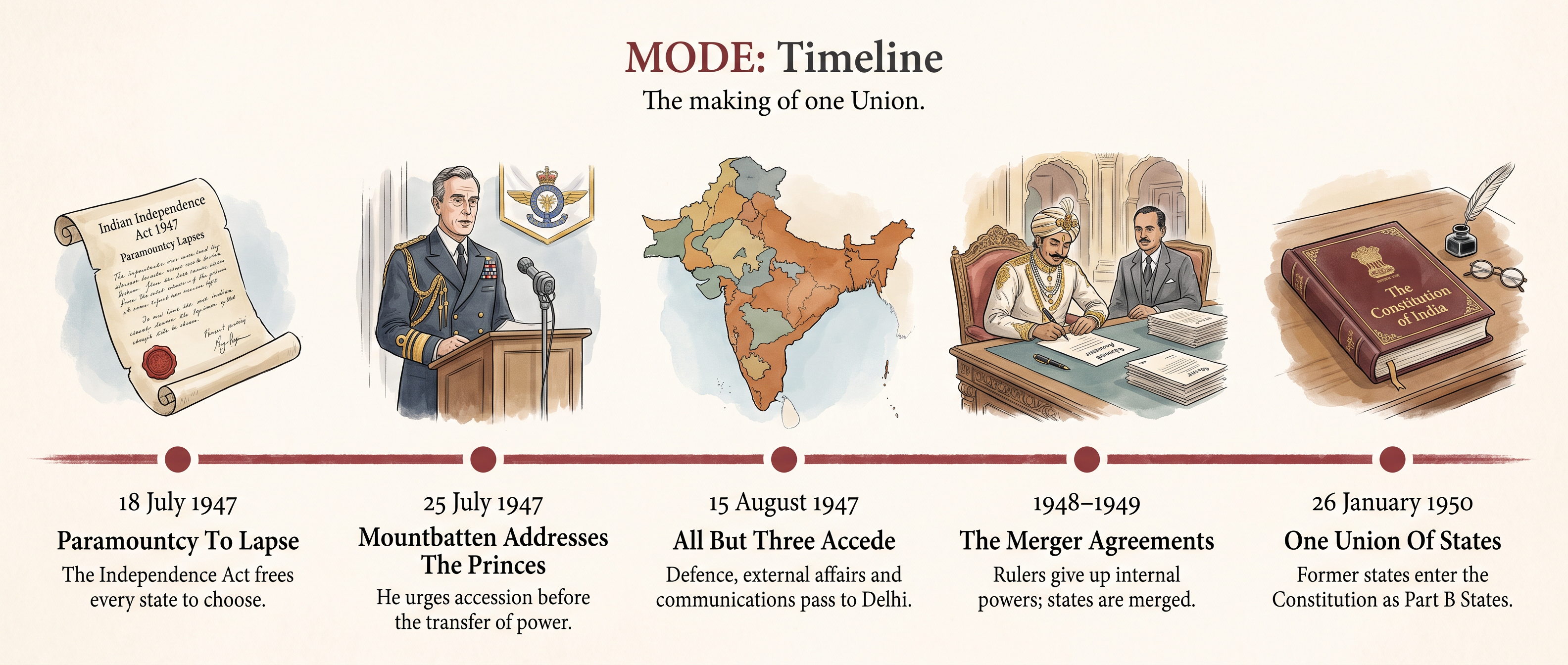
Fig. 2.0 – The making of one Union.
Why This Belongs In A Chapter On Democracy
Integration is usually told as a story about rulers. Its consequence was about voters. Until the states were merged, tens of millions of Indians lived under a prince and had no vote in the national politics of the country they lived in.
Merger dissolved that separate world. By 1951 the whole territory could be cut into constituencies and counted as one electorate — which is what made the election described in section 2.3 possible at all.
2.2 The Three Difficult States
Three states did not accede when the rest did: Junagarh, Hyderabad and Kashmir. They were very different places, and the problem in each was different, but a single awkward fact ran through all three.
In each case the ruler’s choice pointed one way and the state’s geography or its people pointed another. Accession was legally the ruler’s decision alone. Nothing in the Independence Act said he had to consult anybody, and in three states he did not.
What follows is therefore not only a story of soldiers and signatures. It is an argument, conducted in 1947 and 1948, about who a state actually belongs to.
2.2.1 Junagarh
Junagarh was a small coastal state on the Kathiawar peninsula in western India, the block of land that juts into the Arabian Sea south of the Rann of Kutch. Its ruler, Nawab Muhammad Mahabat Khanji III, was a Muslim; the great majority of his subjects were Hindus.
In August 1947 the Nawab announced that Junagarh would accede to Pakistan. Pakistan accepted the accession the following month.
Why The Decision Would Not Hold
The difficulty was on the map before it was anywhere else. Junagarh had no land connection with Pakistan at all. Between the state and the nearest Pakistani territory lay the Arabian Sea, and in every other direction lay states and districts that had already joined India.
The second difficulty was inside the state. Junagarh’s Hindu majority did not accept the decision, and neighbouring rulers on the peninsula, all of whom had acceded to India, protested. People from the state who had settled in Bombay set up a provisional government, the Arzi Hukumat, under Samaldas Gandhi, and organised opposition from outside.
The Government of India refused to recognise the accession and pressed for the question to be put to the people. The argument from Delhi was blunt and practical: if a ruler could hand over a Hindu-majority state that was physically part of India, then accession had become a device for cutting the country into pieces.
How It Ended
By the end of October 1947 the Nawab’s position had collapsed. He left for Pakistan, and his dewan — the chief minister of a princely state — asked the Government of India to take over the administration. Indian forces entered Junagarh in November 1947 without fighting a battle.
In February 1948 a plebiscite was held: a vote open to the whole electorate on a single question, here whether the state should join India or Pakistan. The result was overwhelming. Almost everyone who voted chose India, and Junagarh was absorbed into the Indian Union.
2.2.2 Hyderabad
Hyderabad was the largest princely state in the subcontinent by area, occupying a great block of the Deccan plateau in the centre of the peninsula. It had its own currency, its own railway, its own army and a revenue larger than that of several small countries.
Its ruler, Nizam Osman Ali Khan, was a Muslim, as were most of the senior officials and army officers; the great majority of his subjects were Hindus. When the British left, the Nizam declared that Hyderabad would remain independent, joining neither India nor Pakistan.
Why India Refused
Three arguments were made against an independent Hyderabad, and they were made openly.
The first was strategic. Hyderabad lay in the middle of India, with no coastline of its own and no border with any country other than India. An independent state there, free to make its own foreign policy, would sit across the country’s centre.
The second was practical. The main railway and road routes linking north India with the south ran through Hyderabad’s territory.
The third was political. The Hyderabad State Congress, a party of the state’s own people, was campaigning for accession to India and for responsible government, and its leaders argued that the Nizam’s decision did not represent his subjects.
For the moment, in November 1947, a standstill agreement was signed with India, keeping existing arrangements in place for a year while a settlement was sought.
The Year That Followed
The settlement did not come. Inside the state, an armed volunteer force called the Razakars, organised under the political leader Kasim Razvi, pressed the Nizam’s government to hold out, and attacked villages and travellers in the districts and along the borders. Thousands of people left their homes and crossed into Indian territory, where relief camps were set up for them.
Hyderabad also armed itself and took its case to the United Nations Security Council, arguing that India was coercing an independent state.
Operation Polo
After an ultimatum from Delhi was ignored, the Indian army moved into Hyderabad on 13 September 1948 in an operation code-named Polo, commanded by Major General J. N. Chaudhuri. Resistance was brief. The Nizam ordered a ceasefire on 17 September, and Indian troops entered the city the following day.
The Nizam withdrew his complaint from the Security Council and accepted Indian authority. He was not deposed. In 1950 he was appointed Rajpramukh — the constitutional head of the new Hyderabad state, a position carrying dignity but no governing power.
What The Operation Cost
The five days of military action were short. The communal violence around them was not, and it did not stop when the fighting did. After the army entered, large-scale killings took place in parts of the state, and most of those killed in this second phase were Muslims.
The government appointed a committee led by Pandit Sunderlal to find out what had happened. Its members travelled through the affected districts, took evidence and reported a death toll running into tens of thousands. The report was not published at the time, and no complete count has ever been established.
2.2.3 Kashmir
Jammu and Kashmir lay at the far north of the subcontinent, bordering both of the new Dominions, and running from the plains of Jammu up into the high Himalaya. Its ruler, Maharaja Hari Singh, was a Hindu; the majority of his subjects, particularly in the Kashmir valley, were Muslims.
Hari Singh did what neither of the other two rulers attempted for long: he tried to stay out of the choice altogether. He signed a standstill agreement with Pakistan and delayed a decision on accession, hoping to remain independent between the two.
The Invasion Of October 1947
On 22 October 1947 armed tribesmen from the North-West Frontier region of Pakistan crossed into the state, supported and supplied from Pakistani territory. They advanced through the western districts, burning and looting as they came, and moved towards Srinagar, the state’s summer capital.
The Maharaja’s own forces could not hold them. He appealed to India for military help. India’s answer was that its troops could not enter the territory of a state that had not acceded, and that help would follow accession.
Hari Singh signed the Instrument of Accession on 26 October 1947. Indian soldiers were flown into Srinagar the next day and pushed the invading forces back from the outskirts of the city.
The Condition Attached
When Mountbatten, as Governor-General, accepted the accession on India’s behalf, he attached a statement of intent to his letter of acceptance. It is worth reading closely, because a great deal that has been argued about Kashmir since has turned on it.
The accession itself was legally complete on signature; nothing in this sentence made it conditional in law. What the sentence records is a political undertaking, given at a particular moment, and carrying two conditions of its own — the restoration of order, and the clearing of the invader from the state.
Fighting, The United Nations And The Ceasefire
Sheikh Abdullah, leader of the National Conference, the state’s largest political party, was put in charge of an emergency administration and worked alongside the Indian forces. Fighting continued through 1948 across the west and north of the state.
On 1 January 1948 India took the matter to the United Nations Security Council, complaining of Pakistan’s part in the invasion. Pakistan denied responsibility for the tribesmen and demanded that the state’s future be decided by a plebiscite.
The Security Council’s involvement produced no settlement, but it did produce a ceasefire, which took effect on 1 January 1949. By then Indian forces held roughly two-thirds of the state’s territory. The remainder stayed under Pakistani control and was administered as Azad Kashmir.
The ceasefire line was fixed by agreement in July 1949. It froze the military position of that winter, and it is the origin of the division that has lasted ever since.
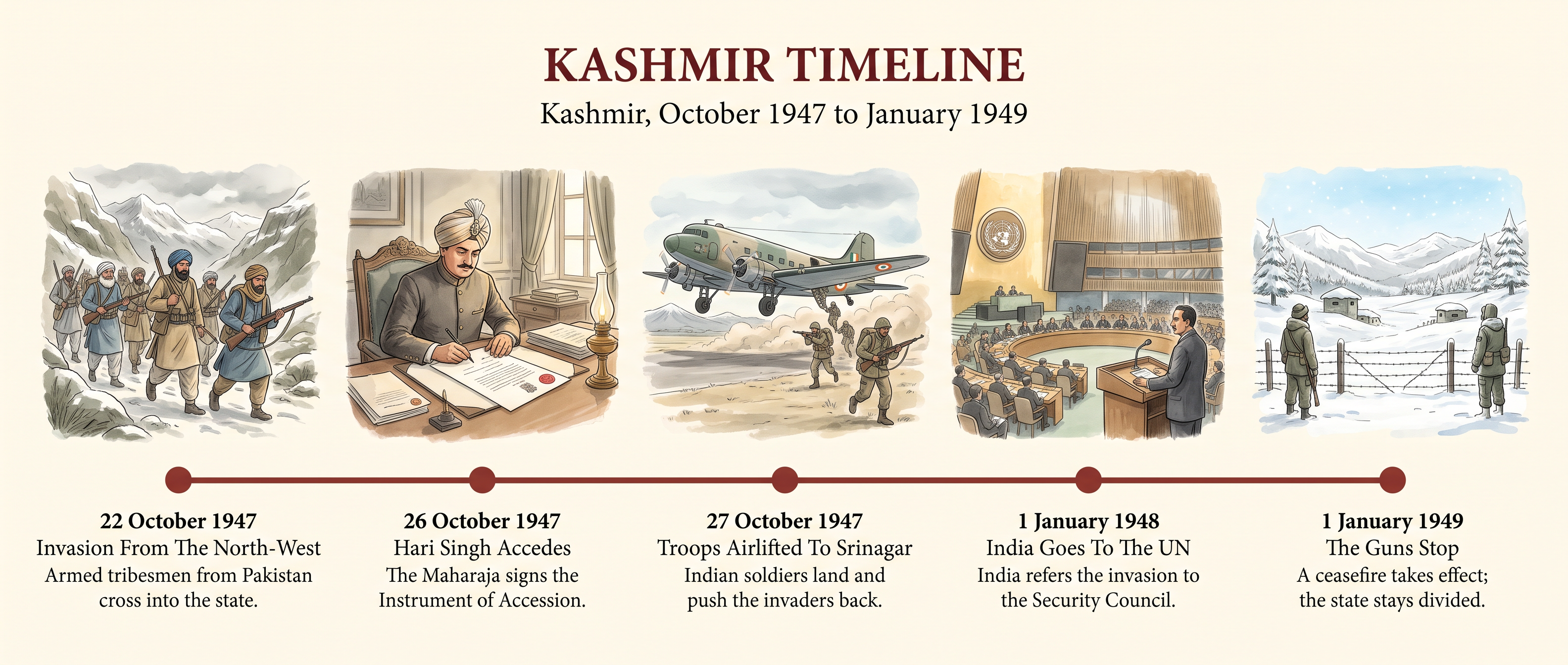
Fig. 2.1 – Kashmir, October 1947 to January 1949.
Map
Map 2.2 Caption: Jammu and Kashmir after the ceasefire of January 1949, showing the line agreed in July of that year. Brief: Map of Jammu and Kashmir showing the full extent of India as officially defined by the Government of India, that is, the whole of the former princely state as Indian territory. Mark the 1949 ceasefire line as a dashed line; label Srinagar and Jammu; show the direction of the October 1947 incursion with a single arrow from the north-west. The caption panel must state that this is the position in 1949 and not present-day administrative boundaries.
Three States, Three Answers
Set the three side by side, and the pattern is not that India always won. It is that the same question was answered three different ways.
In Junagarh the ruler’s signature was overturned by a vote of the people, and the vote settled the matter completely. In Hyderabad neither a signature nor a vote decided it; military force did, and the cost in lives was heavy and is still disputed. In Kashmir the ruler did sign, in circumstances of invasion, and the promised reference to the people never took place — which is why Kashmir, alone of the three, remained an open question long after 1949.
There is a further discomfort worth naming. In Junagarh, India argued that the wishes of the people must override the ruler’s signature. In Kashmir, Pakistan made that same argument, and India relied on the signature.
That is not a reason to dismiss either government. It is a reason to notice that 1947 left two rules for deciding a state’s future — the ruler’s choice, and the people’s — that the two could point in opposite directions, and that nothing in the Independence Act said which one won.
2.3 The First General Election (1952)
By 1950 the territory had been assembled and a Constitution had come into force. What had not yet happened was the thing the Constitution existed for: the people choosing a government.
The election that followed was held on a principle no country of India’s size and poverty had attempted. Universal adult suffrage means that every adult citizen votes, with no qualification of property, income, education, sex or caste. In 1952 the only condition was age: a citizen who had reached twenty-one could vote.
That single decision created the administrative problem of the century. Most of the people now entitled to vote could not read, had never voted before, and in many cases had never been counted by anybody for any purpose.
2.3.1 The Problems Of Preparation
The Election Commission of India was set up on 25 January 1950, the day before the Constitution came into force. Sukumar Sen, a civil servant and mathematician, became the first Chief Election Commissioner. The Commission was made independent of the government of the day, so that the body running an election could not be controlled by the party contesting it.
Sen’s Commission faced four problems, and it is worth naming them separately because the solutions in section 2.3.2 answer them one by one.
Drawing The Constituencies
The country had to be divided into constituencies — the areas that each elect one representative. There were to be 489 seats in the Lok Sabha, the lower house of Parliament, and 3,283 seats in the state legislative assemblies, or Vidhan Sabhas. Every boundary had to be drawn on the ground, in a country whose internal map had itself just been redrawn by the mergers described in section 2.1.
Making The Electoral Roll
An electoral roll is the list of people entitled to vote in a constituency. There was no such list. It had to be compiled from scratch for an electorate of well over a hundred and fifty million people, house by house, in more than a dozen major languages.
The Problem Of Literacy
A ballot paper printed with names is useless to a voter who cannot read. Most Indian adults in 1951 could not, and no election anywhere had been designed around that fact.
Time, Weather And Staff
India’s seasons do not permit a single polling day. The Himalayan valleys are cut off by snow in winter; much of the rest of the country is impassable in the monsoon. And an election on this scale needed more trained staff than the government possessed.
2.3.2 The Solutions The Commission Found
Each problem was met with a practical device, and the devices are more interesting than they look.
Constituencies were demarcated on the ground with the help of state governments, and where a seat carried a reservation for the Scheduled Castes or Scheduled Tribes, two members were returned from a single larger constituency.
The rolls were compiled by house-to-house enumeration, published in draft, and then opened to public claims and objections, so that anybody left off could demand to be put on. That step — publication before finalisation — is what turned a government list into a public document.
Symbols Instead Of Names
The literacy problem produced the most ingenious answer. Every candidate was allotted a symbol, a simple picture that could be recognised without reading: a pair of bullocks, a hut, a lamp, a star.
The symbol was then attached to a physical object. In each polling booth there stood a separate ballot box for every candidate, painted in a distinct colour and marked with that candidate’s symbol. The voter was handed a blank ballot paper and dropped it into the box of the candidate she chose.
This is worth pausing on. The design did not ask an illiterate voter to make a written mark that a literate official would then interpret for her. It let her act on her own, unaided, in a screened enclosure. Secrecy and independence were built into the furniture.
Staggering And Staffing
Polling was spread over nearly four months, from 25 October 1951 to 21 February 1952, beginning in the high Himalaya before the snows closed the passes and ending in the plains. About 224,000 polling booths were built and equipped, millions of steel ballot boxes were manufactured, and roughly a million government employees were trained and deployed to run the poll.
2.3.3 The Process Of Polling
The whole machine can be followed through a single vote.
Step 7 contains a rule that shapes everything in section 2.3.4. India adopted first-past-the-post: the candidate with more votes than any other wins, whether or not he has more than half of them. A party can therefore win a great many seats on well under half the total vote, provided its support is spread across constituencies.
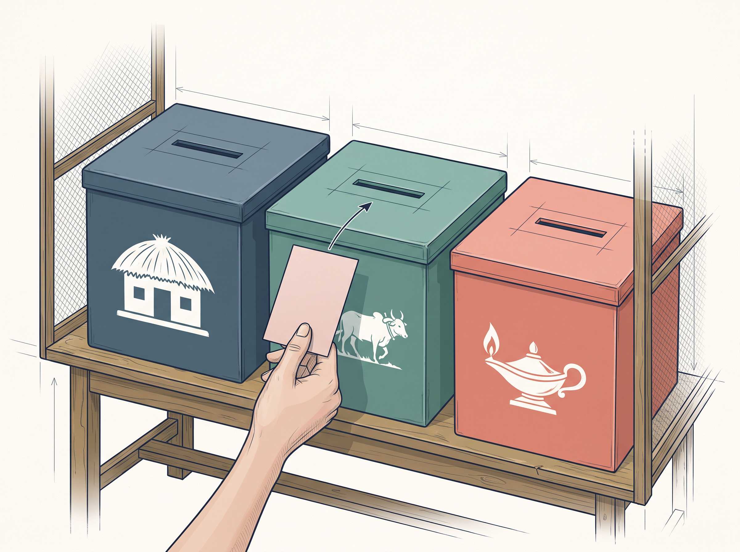
Fig. 2.2 – Voting by symbol in 1952.
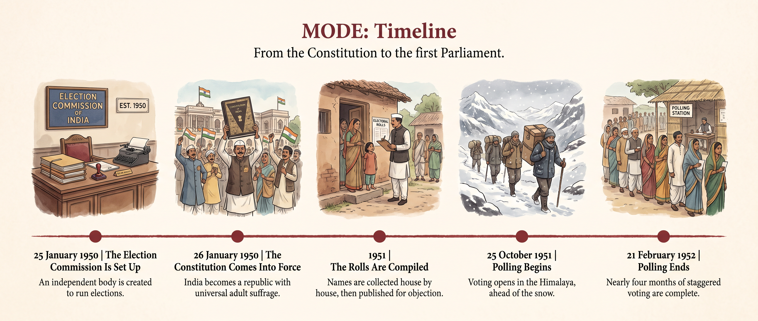
Fig. 2.3 – From the Constitution to the first Parliament.
2.3.4 The Result
Turnout was a little over 45 per cent of the electorate — low by later Indian standards, and remarkable for a first attempt in a country where most voters had to be taught what a ballot box was.
The Indian National Congress won 364 of the 489 Lok Sabha seats, an overwhelming majority, and formed governments in almost every state as well. Jawaharlal Nehru, who had been Prime Minister since August 1947, now held the office with an elected majority behind him.
Read the first two columns against each other and the arithmetic of first-past-the-post appears at once. Congress took roughly three-quarters of the seats with well under half the votes. The Socialist Party did the reverse: it drew a larger share of the vote than the Communists, and won fewer than half as many seats, because its support was thinly spread everywhere instead of concentrated anywhere.
The Communist Party of India, together with allied left groups, formed the largest opposition bloc in the new Parliament. The parties of the Hindu right — the Jana Sangh, the Hindu Mahasabha and the Ram Rajya Parishad — together took only a small fraction of the vote.
2.3.5 The Impact Of The Election
The first result of the election was simply that it had been completed. A great many observers, in India and abroad, had expected universal suffrage to fail here, and it had not.
It Made The Republic Legitimate
A Constitution written by an Assembly that had itself been indirectly elected now rested on a direct popular vote. From 1952 the government’s authority came from the people it governed, and it could be withdrawn by them.
It Established The Congress As The Dominant Party
Congress entered the election with the standing it had earned in the freedom movement and with an organisation in almost every district, and it converted both into power at the centre and in the states. For the next years the serious political argument in India took place as much inside the Congress as between it and its opponents.
It Taught The Opposition Its Own Arithmetic
Small parties with real support had discovered that scattered votes win nothing under first-past-the-post. The lesson produced immediate mergers: in September 1952 the Kisan Mazdoor Praja Party and the Socialist Party joined to form the Praja Socialist Party.
Opposition members were few, but they were present, and they used parliamentary debate to question ministers and criticise policy. A working democracy needs somebody whose job it is to say that the government is wrong, and after 1952 there was.
It Set A Habit
The election also fixed an expectation. Governments in India would be changed by counting, at intervals fixed in advance, by an authority outside the control of the party in office. That expectation is the most important thing the first general election produced, and it was tested repeatedly in the decades that followed.
2.4 The Linguistic Reorganisation Of States
The map India inherited in 1947 had not been designed. The provinces of British India were the accidents of conquest and administrative convenience: Madras Presidency ran from the Tamil south to the Telugu-speaking north, and Bombay Presidency held Marathi, Gujarati and Kannada speakers inside one boundary.
That mattered more after independence than before. Once government was elected, and once it began to work in the languages people actually spoke — in schools, in courts, in offices — a state’s language became a question about who could get educated, employed and heard.
The Congress had accepted the principle long before independence, organising its own provincial units by language from 1920. What nobody had faced was doing it to a country that had just been partitioned.
2.4.1 The Demand And The First Enquiries
The Dar Commission
In 1948 the government appointed a commission under S. K. Dar, a retired judge of the Allahabad High Court, to examine whether the states should be redrawn by language.
Its answer was no. The Commission held that administrative convenience, and not language, should decide boundaries, and warned that reorganising states by language so soon after Partition might endanger national unity.
The JVP Committee
The report satisfied nobody, and the demand grew louder, particularly among Telugu speakers in Madras. In December 1948 the Congress appointed a committee of its three most senior figures — Jawaharlal Nehru, Vallabhbhai Patel and Pattabhi Sitaramayya, whose initials gave the committee its name — to look again.
The JVP Committee reported in April 1949, and it too refused, though on a narrower ground than Dar’s. Its objection was to the timing.
The rest of the report explained why: new provinces would slow the consolidation of what had just been won, dislocate an administrative and financial structure that was still being built, and set loose forces of disruption while the country was still forming.
2.4.2 Andhra
The Telugu-speaking districts in the north of Madras state had the oldest and best organised of the linguistic demands. When the JVP Committee’s answer came, the movement did not subside.
In October 1952 Potti Sreeramulu, a veteran Congress worker, began a fast unto death in Madras for a separate Telugu state. The government did not concede. He died on the fifty-eighth day, in December 1952.
His death changed everything within seventy-two hours. Crowds joined his funeral procession, protest spread through the Telugu districts, property was attacked and people were killed in clashes with the police. Within days the Prime Minister announced that a Telugu state would be created.
Andhra State came into being on 1 October 1953, formed out of the Telugu-speaking districts cut away from Madras. The remainder of Madras state was left as a mainly Tamil-speaking state.
Note the precise name, because it is easy to get wrong. What was created in 1953 was Andhra State. Andhra Pradesh, which added the Telugu-speaking districts of the former Hyderabad state, came three years later, under the Act described next.
2.4.3 The States Reorganisation Act, 1956
Having conceded once, the government could not hold the line elsewhere. In 1953 Nehru announced a commission to examine the whole question rather than one demand at a time.
The States Reorganisation Commission was chaired by Fazl Ali, with K. M. Panikkar and Hriday Nath Kunzru as its members. It reported in 1955, and recommended that language should be a major basis for reorganisation — but not the only one. Financial viability, administrative workability and the unity of the country were to be weighed alongside it.
Parliament passed the States Reorganisation Act in 1956, and it took effect on 1 November 1956, alongside a constitutional amendment that made the changes possible.
The Features Of The Act
The Act did four things worth separating out.
First, it made language the principal basis of the internal map. Boundaries were redrawn so that a state generally corresponded to a major language area, and the old Presidency boundaries disappeared.
Second, it abolished the four-fold classification of states that the Constitution had created in 1950. The distinction between Part A States (the former British provinces), Part B States (the former princely states and their unions) and Part C States vanished, and with it the office of Rajpramukh. All states now stood on the same footing, each with a Governor appointed by the President.
Third, it produced 14 states and 6 union territories. The states were Andhra Pradesh, Assam, Bihar, Bombay, Jammu and Kashmir, Kerala, Madhya Pradesh, Madras, Mysore, Orissa, Punjab, Rajasthan, Uttar Pradesh and West Bengal. The union territories — Delhi, Himachal Pradesh, Manipur, Tripura, the Andaman and Nicobar Islands, and the Laccadive, Minicoy and Amindivi Islands — were administered from the centre rather than by an elected state government.
Fourth, it moved territory in large blocks. Marathi-speaking districts from the former Central Provinces and Berar, and from the former Hyderabad state, were transferred into Bombay state; Telugu-speaking districts of Hyderabad went to Andhra to make Andhra Pradesh; Kerala was assembled from Travancore–Cochin and the Malayalam-speaking districts of Madras.
Map
Map 2.3 Caption: India after the States Reorganisation Act came into effect on 1 November 1956. Brief: Political map of India as reorganised in 1956, showing the full extent of India as officially defined by the Government of India. Name each of the fourteen states with its principal language in brackets beneath the name; mark the six union territories by number with a key panel. Use a distinct line style for state boundaries and another for union territory boundaries. The caption panel must state that these are the boundaries of 1956 and not present-day boundaries.
2.4.4 Bombay
The Act settled most of the map. It did not settle Bombay, and the reason is instructive: Bombay state contained two large language groups and one very valuable city.
The Commission had recommended keeping a bilingual Bombay state, with Marathi and Gujarati speakers together. Neither group accepted it. The Samyukta Maharashtra Samiti campaigned for a Marathi state including the city of Bombay; the Mahagujarat Janata Parishad campaigned for a separate Gujarati state.
The dispute turned on the city itself. Bombay was India’s commercial capital and its largest industrial centre. Its industry and trade were heavily Gujarati; its working population and its surrounding districts were overwhelmingly Marathi.
The agitation was sustained and it was costly. Demonstrations in the city met police firing, and a large number of protesters were killed in the mid-1950s — deaths that remain a central memory of the movement in Maharashtra.
The government gave way in 1960. The Bombay Reorganisation Act divided the state on 1 May 1960 into Maharashtra, with Bombay as its capital, and Gujarat, with Ahmedabad as its capital.
2.4.5 Punjab
Punjab was the second unsettled case, and the hardest, because language scroll could not be separated from religion.
The Akali Dal, led by Master Tara Singh, demanded a Punjabi Suba — a state in which Punjabi, written in the Gurmukhi script, would be the language of government. In linguistic terms the demand was of exactly the kind the 1956 Act had granted elsewhere.
The government treated it differently. It argued that the demand was in substance a demand for a state where Sikhs would be a majority, and therefore religious rather than linguistic. Supporters of the Suba replied that the same test had not been applied to Andhra or Maharashtra, and that they were asking only for what other language groups had received.
The evidence was genuinely tangled. Many Punjabi-speaking Hindus recorded Hindi as their mother tongue in the census, which made the language map look smaller than the language itself was, and hardened the suspicion on each side that the other was arguing in bad faith.
The States Reorganisation Commission rejected the Punjabi Suba in 1955. In 1956 the Act went the other way and made Punjab larger, merging the Patiala and East Punjab States Union into it.
The demand did not go away, and after a decade of agitation the government conceded. The Punjab Reorganisation Act came into effect on 1 November 1966. The Punjabi-speaking areas remained as Punjab; the Hindi-speaking areas in the south and east became the new state of Haryana; the hill districts in the north went to Himachal Pradesh; and Chandigarh, built as Punjab’s new capital after Partition, became a union territory serving as the capital of both states.
Reorganisation ended there, on the last year of this chapter’s period, and it ended without settling everything. Chandigarh’s status and the sharing of river waters were left open, and both would return.
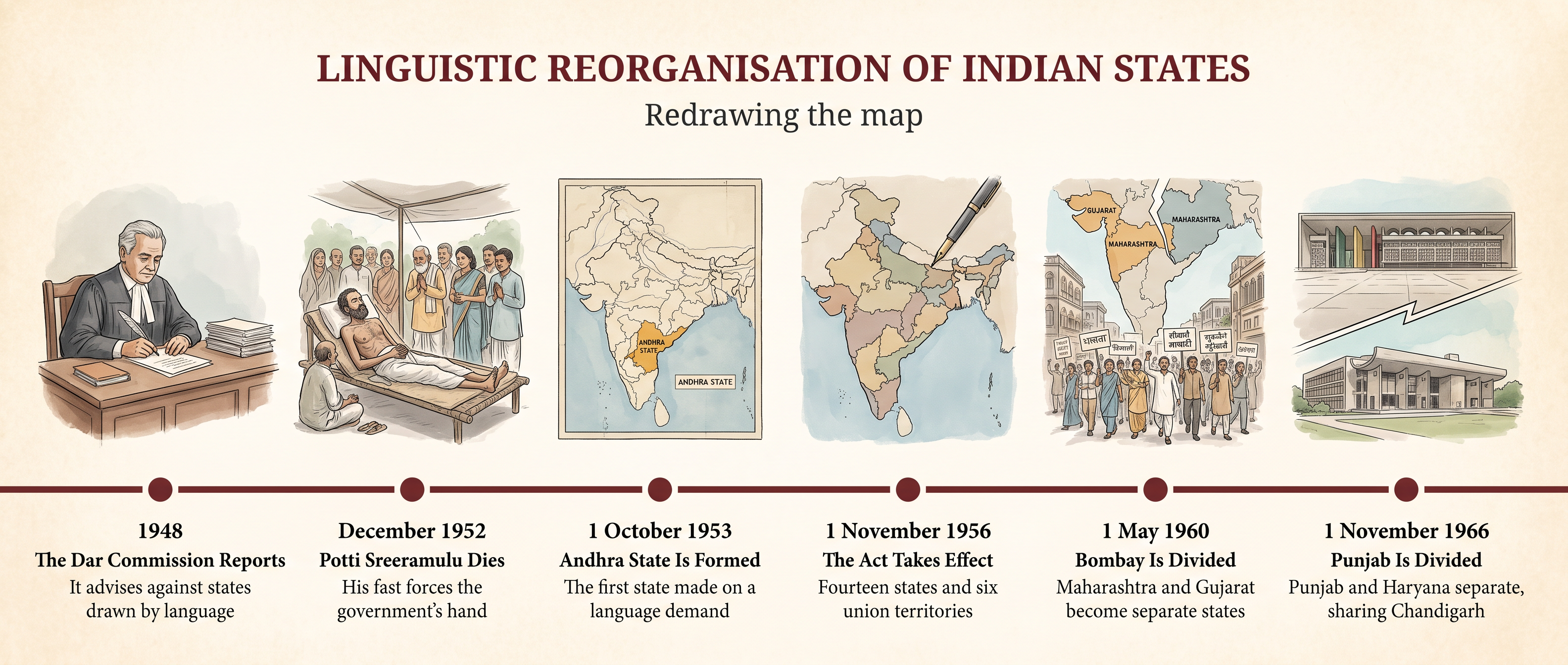
Fig. 2.4 – Redrawing the map.
What Reorganisation Did
The immediate effects were practical. State governments could now administer, legislate and teach in the language most of their people spoke, and regional literatures, newspapers and universities grew on the back of it.
The larger effect was political, and it is still argued about. India had conceded a principle that many people in 1948 expected to break the country: that a language community could demand and receive a state of its own.
2.5 Summary
Integrating The Princely States
- In 1947 the subcontinent was not one territory: 565 princely states, holding two-fifths of its area and about a quarter of its people, lay outside the directly ruled provinces.
- A princely state’s ruler kept his internal administration but accepted British paramountcy, which controlled defence, foreign relations and everything above the level of a single state.
- The Indian Independence Act let paramountcy lapse rather than pass it to India, so the states were released from every tie and bound to nothing.
- Sardar Patel, running the new States Department, kept the first step small: the Instrument of Accession surrendered only defence, external affairs and communications, and a standstill agreement continued existing arrangements.
- He combined reward, argument and threat — privy purses and guaranteed titles, the logic of geography and popular opinion, and open readiness to use force.
- By 15 August 1947 every state inside India had acceded except three.
- The merger agreements of 1948–49 were the real reorganisation: rulers gave up internal powers, and states were absorbed into provinces or grouped into new units such as Saurashtra, Rajasthan, Madhya Bharat and PEPSU.
- Integration mattered for democracy because it dissolved a separate political world; only after it could the whole country be cut into constituencies and counted as one electorate.
The Three Difficult States
- All three cases turned on the same clash: the ruler’s legal right to choose against the wishes of his subjects, with nothing in the law to say which should win.
- Junagarh’s Nawab acceded to Pakistan though his state had no land link to it and his people were overwhelmingly Hindu; blockade, protest and administrative collapse followed, he fled, his dewan invited India in, and a plebiscite in 1948 confirmed accession to India.
- Hyderabad’s Nizam claimed independence for a landlocked, wealthy state astride India’s north–south communications; a standstill agreement bought a year, during which the Razakars spread violence.
- Operation Polo in September 1948 ended resistance in days; severe communal violence followed, and the Sunderlal Committee’s estimate of the deaths has been disputed ever since.
- Kashmir’s Maharaja wanted independence, was invaded by armed tribesmen in October 1947, and acceded only when he needed Indian troops.
- India accepted the accession with a condition of its own — a later reference to the people — took the dispute to the Security Council, and accepted a ceasefire on 1 January 1949 along a line fixed later that year.
- Read together, the cases show both governments using whichever principle suited the particular state, which is why neither has ever been able to settle the argument on principle alone.
The First General Election
- The Constitution gave every adult the vote at once, where older democracies had extended the franchise by stages over a century.
- The problems were size, illiteracy, a population still moving after Partition, and the complete absence of constituencies, staff, boxes and precedent.
- The rolls themselves carried the country’s assumptions: millions of women were entered as somebody’s wife or daughter rather than by name, and had to be registered afresh before they could vote.
- The Election Commission, created a day before the Constitution came into force, is independent of the government precisely because an election run by the ruling party is not an election.
- Illiteracy was answered by design, not by exclusion: every candidate had a symbol and his own ballot box, so a voter who could read nothing voted exactly as intended.
- The Congress won 364 of 489 Lok Sabha seats — about three-quarters — with about 45 per cent of the vote, which is what first-past-the-post does to a divided opposition.
- The election’s impact was that it worked, that it pushed defeated parties to merge, that it produced a small opposition which held a dominant party to account by argument, and that it turned a right on paper into an ordinary practice.
Redrawing The Map By Language
- The provinces of 1947 recorded the order of British conquest, not the distribution of Indian languages.
- The Dar Commission in 1948 and the JVP Committee in 1949 both rejected linguistic states as dangerous to a newly divided country, though the JVP Committee allowed that Andhra might have to be an exception.
- Article 3 gave Parliament the power to create, merge, divide and rename states without the consent of the state concerned.
- Potti Sreeramulu’s death in December 1952 and the protests that followed forced the concession of Andhra State in 1953, and once one language claim had been granted the rest could not be refused.
- The States Reorganisation Commission accepted language as a major basis but not the only one, weighing administration, finance and security alongside it.
- The Act of 1956 abolished the Part A, B and C classification and created fourteen states and six union territories on the same constitutional footing.
- Bombay was kept bilingual against the wishes of both communities and was divided into Maharashtra and Gujarat only in 1960, after four years of agitation.
- Punjab’s demand for a Punjabi Suba was refused in 1956 because language and religion overlapped there, and was conceded in 1966, when Punjab, Haryana and a shared capital at Chandigarh emerged.
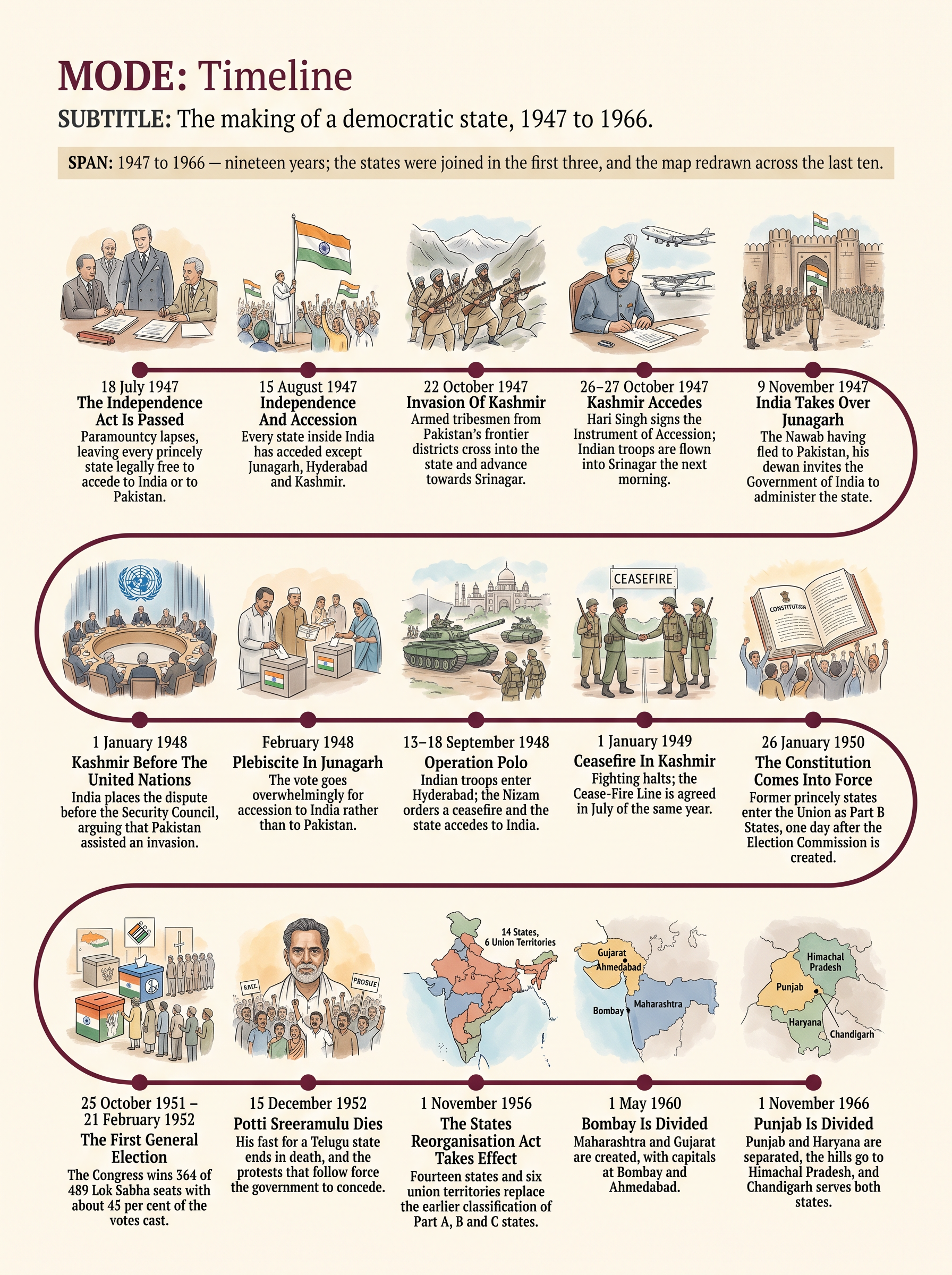
Fig. 2.5 – The making of a democratic state, 1947 to 1966.
What The Evidence Cannot Tell Us
Almost everything in this chapter comes from records the state made about itself: signed accession papers, commission reports, election returns and official enquiries. They are precise about decisions, dates and totals, and nearly silent about the people those decisions were made for.
The subjects of a princely state left no signature on the Instrument that transferred them. The returns of 1952 record how many papers went into each box and never why. The census could tell the government what people declared their language to be, but not what they spoke at home or what they wanted for their children.
So the story of these nineteen years is best read as the record of what a new state did, and only indirectly as the record of what a new nation felt. The second story is much harder to recover, and most of it was never written down at all.
2.6 Check Your Memory
What was paramountcy, and what did the Indian Independence Act do with it in 1947? In your answer, explain why the Act left the princely states with a legal problem rather than solving one.
The Instrument of Accession transferred only three subjects to the central government. Name them, and explain why Sardar Patel found it useful to ask for so little at the first stage.
Junagarh acceded to Pakistan in August 1947 and was part of India within a year. Set out, in order, the steps by which that happened, and identify the point at which the accession to Pakistan became impossible to sustain.
Read Source 2.3 again. What condition did India attach when it accepted the accession of Kashmir, and what does the sentence leave undefined? Explain why those gaps have mattered since.
Study Table 2.1. The Congress won 364 of the 489 Lok Sabha seats with roughly 45 per cent of the votes cast. Explain how a party supported by fewer than half the voters came to hold three-quarters of the seats, and state one thing this table cannot tell you about the election.
The chapter says that census returns in Punjab measured allegiance as much as speech. Explain what this means, using the difficulty over Punjabi and Hindi, and say what it suggests about using official figures as evidence of what people actually spoke.
Distinguish between the Instrument of Accession and the merger agreement. What did a ruler give up under each, and why was the second document necessary once the first had been signed?
The action taken in Hyderabad in September 1948 has been described both as a police action and as an invasion. Set out the strongest case for each description, and explain what the choice of word implies about whether accession was ever really a free choice.
Using Map 2.3, locate the states created or enlarged in 1956 for Malayalam, Kannada and Telugu speakers. Then explain what claim the boundaries on this map are making about the people inside them, and why that claim could never be exactly true.
In Junagarh, India argued that the wishes of the people should override the ruler’s signature; in Kashmir, it relied on the ruler’s signature. Was this inconsistency, or was it the unavoidable result of the way 1947 left the princely states? Argue your case using the evidence in this chapter.