Chapter 5: India’s Foreign Policy
Aksai Chin is one of the emptiest places on earth. It is a plateau in the far north of Ladakh, about five thousand metres above sea level, salt-crusted, treeless and almost without rain. Nobody farms there. Almost nobody lives there. In the 1950s no Indian road reached it, and no Indian village looked out on it.
Somewhere in that emptiness, through the middle of that decade, a road was being built. It ran from Xinjiang in western China down into Tibet, and for a long stretch it crossed ground that Indian maps showed as Indian.
India did not find out by seeing it. India found out by reading. The completion of the highway was reported in the Chinese press, and Chinese maps printed the line of it. Officials in Delhi laid those maps beside their own and saw that the two did not agree — not here in the west, and not at the eastern end of the frontier either.
Only then were patrols sent north to look. They confirmed that the road was there. One party did not come back; its men were held by Chinese troops and released later.
By 1958 two governments were exchanging careful written notes about a stretch of frozen rock that hardly anyone on either side had ever visited. Four years later they were at war over it.
Map
Map 5.1 Caption: The northern frontier in the late 1950s, showing the two sectors where Indian and Chinese maps did not agree. Brief: Political map of northern India and its neighbours as they stood in the late 1950s; show the full extent of India as officially defined by the Government of India; shade the Aksai Chin sector in the west and the eastern sector along the Assam Himalaya in a single tone marked as claimed by both India and China; mark the approximate line of the Xinjiang–Tibet highway; label Ladakh, Aksai Chin, Xinjiang, Tibet and the North-East Frontier Agency; state on the map that these are boundaries as understood in the 1950s and not present-day boundaries; do not mark battle sites or dates.
5.1 The First Indo-Pak War (1947–49)
India and Pakistan became independent states in August 1947. Within ten weeks their soldiers were fighting each other in the mountains of Kashmir. The war that followed was never formally declared, lasted fourteen months, and ended without settling the question it was fought over.
That question has shaped almost everything in this chapter. Two of the three later wars with Pakistan grew out of it. To understand why the fighting began, we have to begin not with the armies but with a decision one ruler could not bring himself to make.
5.1.1 Kashmir In 1947: The Setting
About two-fifths of the territory of British India was not ruled directly by the British at all. It was made up of princely states — territories under Indian rulers who accepted British supremacy in return for keeping their thrones. That supremacy was called paramountcy: the Crown controlled their defence and their external relations, and they controlled almost everything else.
Paramountcy ended on 15 August 1947. It did not pass to India or to Pakistan. Each ruler was left to accede to one dominion or the other, and was advised to be guided by where his state lay and who lived in it.
A State That Chose Neither
Jammu and Kashmir was the largest princely state by area. It stretched from the plains of Jammu up through the Valley of Kashmir to the high desert of Ladakh, and it touched both new dominions as well as Tibet and Xinjiang. Most of its people were Muslims. Its ruler, Maharaja Hari Singh, was a Hindu of the Dogra line.
Hari Singh did not want to join either side. He hoped to stay independent, and he played for time. He offered both dominions a standstill agreement — a temporary arrangement to keep post, telegraph, railways and trade running while the question of accession was left open. Pakistan signed one. India did not, and asked for talks instead.
Time was the one thing he did not have. In the summer of 1947 the people of Poonch, in the west of the state, rose against his administration over taxes and repression. Supplies of fuel, salt and other goods coming in from the Pakistani side began to fail. Meanwhile the largest political organisation in the Valley, the National Conference led by Sheikh Abdullah, had spent years demanding that the Maharaja’s rule be replaced by a popular government.
5.1.2 The Invasion And The Instrument Of Accession
On 22 October 1947 armed tribesmen from the North-West Frontier crossed into the state near Muzaffarabad and drove down the Jhelum valley road towards Srinagar. They were not a private adventure. They travelled in lorries, they were armed and led by men with military experience, and they moved through Pakistani territory to reach the frontier.
The state forces broke. The invaders took town after town along the road, looting as they went and killing civilians, and reached Baramula, some fifty kilometres from Srinagar. There they halted to plunder. That halt probably saved the capital.
Hari Singh, by now in Jammu, asked Delhi for troops. India’s answer was that it could not send its army into a state that was not part of India. On 26 October 1947 the Maharaja signed the Instrument of Accession, the document by which a princely state joined a dominion, handing over defence, external affairs and communications. India accepted it the next day, adding that the accession should be referred to the people of the state once the invaders had been cleared and order restored.
On 27 October 1947 Indian infantry were flown into Srinagar in transport aircraft and secured the airfield while the fighting was still moving towards the town. Everything that followed depended on that airfield staying in Indian hands.
5.1.3 The Course Of The War
Indian troops cleared the invaders from the outskirts of Srinagar within days and then pushed them back down the valley road. At the end of October Sheikh Abdullah was placed at the head of an emergency administration in the state, so that the Indian army was operating alongside a popular leader rather than only a discredited ruler.
The fighting then spread out along the whole length of the state and slowed down. In the west it settled into a grinding contest around Poonch and Uri. In the north the invaders reached far into Gilgit and Baltistan. In the east, Ladakh was cut off by snow and distance; Indian troops forced the pass at Zoji La in November 1948, using tanks at an altitude where nobody had used them before, and reopened the road to Leh.
By the summer of 1948 the war had changed character. Pakistan’s regular army was in the state, and said so. What had begun as a raid by tribesmen was now a war between two armies that had been one army a year earlier, commanded in places by officers who had served together.
By the end of 1948 the front had stopped moving. India held the Valley, Jammu and Ladakh — roughly two-thirds of the former state. Pakistan held a strip in the west, which it called ‘Azad Kashmir’, and the thinly peopled northern areas.
5.1.4 The United Nations And The Ceasefire Line
On 1 January 1948 India took the dispute to the Security Council of the United Nations, under the article of the Charter that allows a member to bring a dangerous dispute before it. India complained that Pakistan was assisting the invaders and asked that it be made to stop. Pakistan denied any involvement and replied by challenging the accession itself and demanding a plebiscite — a direct vote of the people of the state on which country to join.
The Council set up a commission for India and Pakistan, which produced a plan in three stages. First a ceasefire. Then a truce, under which Pakistan would withdraw its troops and the tribesmen, and India would cut its own forces down to the minimum needed for order. Only then a plebiscite. Both governments accepted the plan.
Only the first stage was ever carried out. The ceasefire came into effect on 1 January 1949. In July 1949 military representatives of the two sides met at Karachi and drew the Ceasefire Line on the map, marking where each army stood. The withdrawal never took place, because each side insisted the other move first, and so the vote at the end of the sequence was never held.
Map
Map 5.2 Caption: Jammu and Kashmir after the ceasefire of January 1949, showing the areas held by each side. Brief: Map of the former princely state of Jammu and Kashmir within its 1947 limits, set in a small locator map showing the full extent of India as officially defined by the Government of India; mark the Ceasefire Line as agreed in July 1949; shade separately the area held by India and the area held by Pakistan; label Jammu, Srinagar, Baramula, Muzaffarabad, Uri, Poonch, Gilgit, Zoji La and Leh; state in the key that this shows positions in 1949 and not present-day administration; do not name any later line or later conflict.
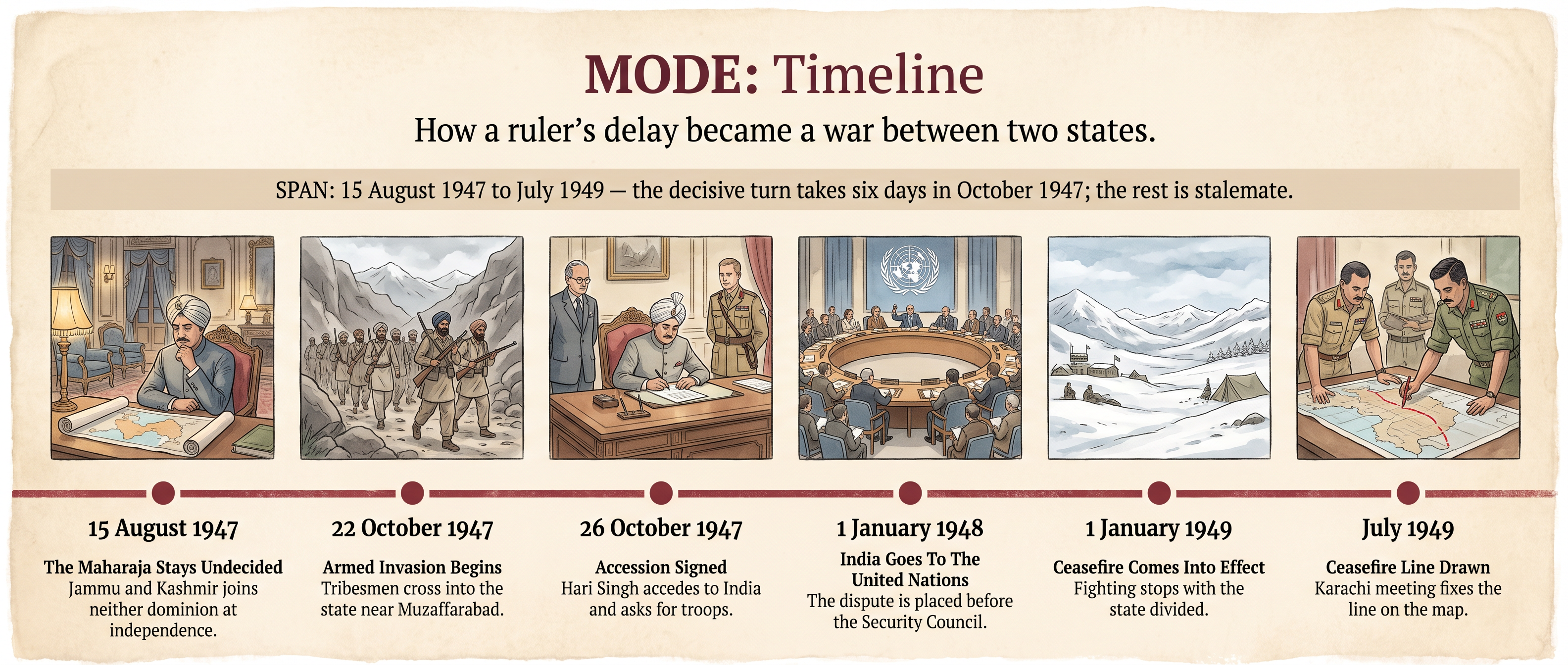
Fig. 5.0 – From Independence To The Ceasefire Line.
5.1.5 Consequences Of The First War
The most obvious consequence was a division on the ground. The state was cut in two along a line drawn by where soldiers happened to be standing when the guns stopped, not by any principle either government would have chosen. Villages, roads and grazing grounds were separated from one another, and families were left on opposite sides of a line they had never crossed before.
The second consequence was that the dispute stopped being a matter between two governments. Once it was on the agenda of the Security Council it acquired an international audience, a commission, and a promised plebiscite that neither side could deliver and neither side could publicly abandon. Every later negotiation had to start from that unfinished promise.
The third consequence was military. Both new states, poor and short of everything, now had to garrison a long ceasefire line in difficult country. Kashmir became the fixed point around which each army planned. Pakistan had not obtained the state and did not accept the outcome; India held most of it and treated the question as closed. Those two positions were still in place in 1965, which is where the next war began.
5.2 The Second Indo-Pak War (1965)
Sixteen years passed between the ceasefire of 1949 and the next war. They were not quiet years, but the Ceasefire Line held. What broke it in 1965 was a calculation made in Rawalpindi: that India was weaker than it looked, that the people of the Valley would rise if given the chance, and that Kashmir could still be taken by force before India recovered its strength.
Every part of that calculation turned out to be wrong. Understanding why it was made at all is the key to this war.
5.2.1 Causes: From The Rann Of Kutch To The Ceasefire Line
Three things had changed since the first war. India had been defeated by China in 1962 and its army was visibly shaken. Jawaharlal Nehru had died in May 1964, and his successor, Lal Bahadur Shastri, was widely read abroad as a mild man who would not fight. And Pakistan’s army had been re-equipped with American tanks and aircraft under the alliances it had joined in the 1950s, which gave its commanders a belief that they held a temporary advantage in equipment.
The Testing Ground
That belief was tested first in an unlikely place. The Rann of Kutch is a vast salt marsh on the border of Gujarat, flooded for part of the year and almost impossible to hold with troops. Early in 1965 border patrols of the two countries clashed there. India’s response was slow and cautious, partly because the ground was so bad for military movement.
Britain helped arrange a ceasefire in June 1965, and the two governments agreed to send the Kutch dispute to an international tribunal, which gave its award three years later and divided the disputed ground, awarding Pakistan a small part of what it had claimed. The important effect of Kutch was not the award. It was the conclusion Pakistan’s leadership drew: that India would not fight hard.
Infiltration Across The Ceasefire Line
In August 1965 several thousand armed men, in civilian clothing and trained by the Pakistan army, crossed the Ceasefire Line into Indian-administered Kashmir. The plan was that they would blend into the population, attack bridges, posts and communications, and set off a general rising that Pakistan could then support openly.
The rising did not come. Villagers and townspeople who met the infiltrators reported them to the police and the army, and the columns were hunted down over the following weeks. The people of the Valley had many quarrels with Delhi, but they did not treat armed strangers sent from across the line as liberators.
5.2.2 The Course Of The War
India’s answer was to attack the routes the infiltrators were using. Indian troops crossed the Ceasefire Line in late August, took the Haji Pir Pass and seized posts in the Uri and Tithwal sectors, closing the passes behind the men who had come through.
On 1 September Pakistan launched an armoured attack in the Chhamb sector, in the south-west of Jammu, driving towards the town of Akhnoor. The aim was to cut the road that linked Jammu to the rest of Kashmir. If it had succeeded, the Indian forces in the Valley would have been left hanging on a single air link.
The War Spreads To Punjab
On 6 September the Indian army crossed the international border in Punjab and advanced towards Lahore, with a second thrust towards Sialkot. This was a deliberate widening of the war, and it worked as intended: Pakistan had to pull its armour away from Chhamb to defend its own cities.
The Sialkot sector then saw some of the largest tank fighting anywhere since the Second World War, and both air forces were in action over the plains. Neither side achieved a breakthrough. Both were burning through ammunition, aircraft and armour faster than they could replace them, and both had suppliers who had stopped supplying.
The United States and Britain suspended military aid to both countries when the fighting began — a heavier blow to Pakistan, whose equipment was mostly American. The Security Council called for a ceasefire, and after about three weeks of fighting the guns stopped on 23 September 1965.
Map
Map 5.3 Caption: The fronts of the 1965 war, from the Rann of Kutch in April to the Punjab plains in September. Brief: Map of the western sector showing the full extent of India as officially defined by the Government of India; mark the international border and the Ceasefire Line as they stood in 1965; label the Rann of Kutch, Chhamb, Akhnoor, Haji Pir Pass, Uri, Tithwal, Lahore, Sialkot, Amritsar and Jammu; use arrows to show the three main lines of attack — the Pakistani thrust at Chhamb, the Indian move across the Ceasefire Line at Haji Pir, and the Indian advance towards Lahore and Sialkot; do not shade any territory as gained, since positions were restored afterwards.
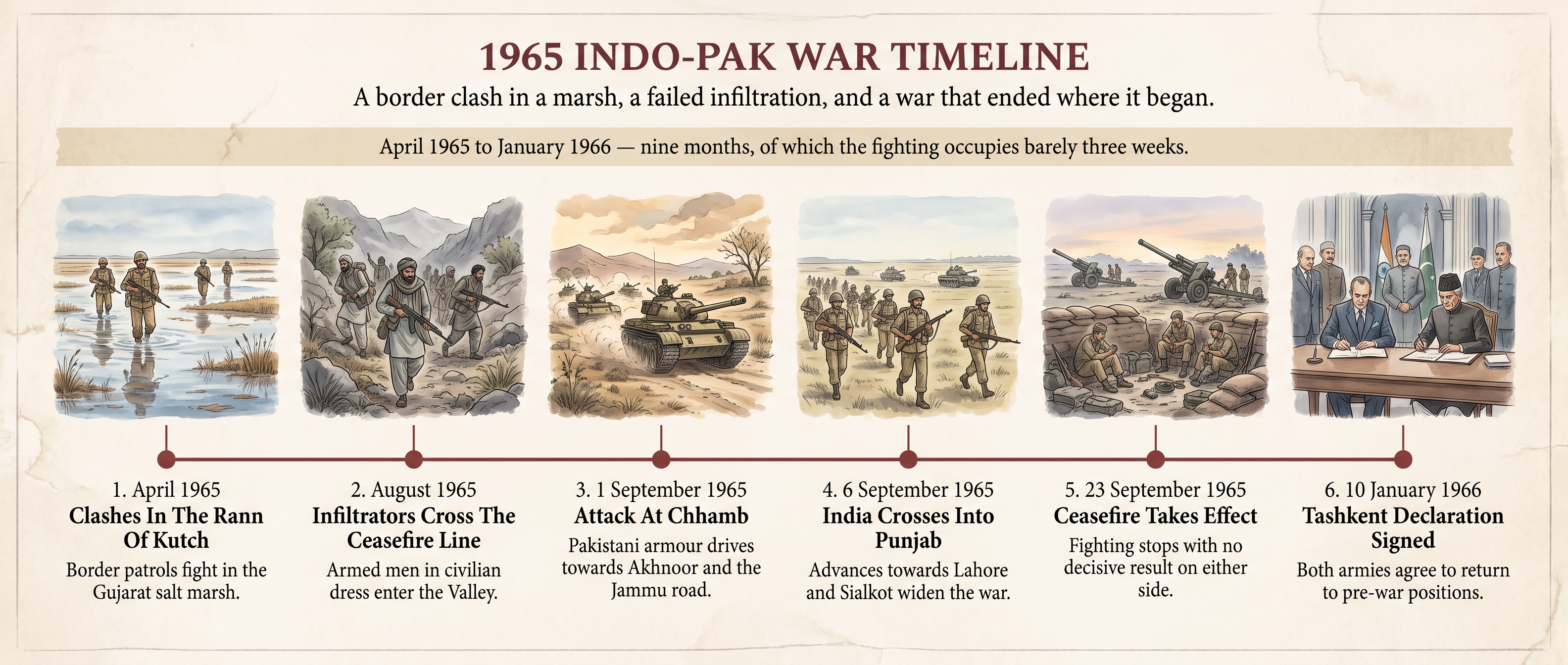
Fig. 5.1 – The Year Of The Second War.
5.2.3 The Tashkent Agreement
Neither army had won and neither government could say so at home. The opening came from an unexpected direction. The Soviet Union, which had no wish to see a war on its southern flank pull China further into the region, offered to host talks.
Shastri and President Ayub Khan of Pakistan met at Tashkent, then the capital of the Uzbek Soviet Socialist Republic in the Soviet Union, and signed a declaration on 10 January 1966. Its terms were simple and almost entirely about undoing the war. Both armies would withdraw to the positions they had held before the fighting of August 1965. Diplomatic relations would be restored, prisoners returned, and each side undertook not to interfere in the internal affairs of the other. Disputes were to be settled peacefully.
The talks were mediated by the Soviet Premier, Alexei Kosygin, and this was itself a change worth noticing: a quarrel in South Asia had been settled in a Soviet city, with neither Britain nor the United States in the room. Hours after signing, Lal Bahadur Shastri died at Tashkent of a heart attack.
5.2.4 Consequences Of The Second War
On the map, nothing changed. Under the Tashkent Declaration both sides pulled back to where they had been in early August 1965, and India gave up the Haji Pir Pass it had taken at some cost. The Ceasefire Line of 1949 was restored intact.
Everything else changed. Pakistan’s plan had rested on a rising in Kashmir that did not happen, and the failure was public. India, which had entered the war shaken by 1962, came out of it with its army’s confidence partly restored. Both economies took a serious blow at a moment when neither could afford one, and the suspension of Western military supplies forced both to look for new sources of weapons.
That search redrew the diplomatic map of the region. Pakistan, convinced that its American ally had abandoned it in a crisis, moved steadily closer to China. India, having been given a hearing and a venue by the Soviet Union, moved closer to Moscow. Within six years those alignments would matter a great deal.
Above all, 1965 established a pattern. A dispute over Kashmir led to fighting, the fighting spread beyond Kashmir, outside powers pressed for a ceasefire, the armies went back to where they started, and the dispute remained. The next war, in 1971, broke that pattern completely — because it was not fought over Kashmir at all.
5.3 The Third Indo-Pak War (1971)
The first two wars were fought over Kashmir. The third was not. It began as a political crisis inside Pakistan, more than a thousand kilometres from the Ceasefire Line, and it ended with the map of South Asia redrawn and a new country in existence.
It was also the shortest of the three, and the only one that produced a clear military result.
5.3.1 Causes: The Crisis In East Pakistan
Pakistan had been created in 1947 in two pieces. West Pakistan and East Pakistan were separated by about sixteen hundred kilometres of Indian territory, and by almost everything else — language, dress, food, landscape and history. The one thing they shared was religion.
More than half of Pakistan’s people lived in the eastern wing. Almost all of its political power, its army officers, its civil servants and its development spending were concentrated in the western wing. East Pakistan’s jute earned much of the country’s foreign exchange, and much of that money was spent in the west. Bengali speakers had also had to fight, in the early 1950s, simply to have their language recognised alongside Urdu as a language of the state.
An Election And Its Refusal
By the late 1960s the Awami League, led by Sheikh Mujibur Rahman, had turned this resentment into a programme: the eastern wing should run its own affairs, leaving only defence and foreign policy to the central government.
In the general election of December 1970 — the first held in Pakistan on the basis of one person, one vote — the Awami League won almost every seat in East Pakistan. Because the east held more seats than the west, that gave the party an absolute majority in the National Assembly and the right to form the government of the whole country.
It never took office. The President, General Yahya Khan, and the leading politician of the western wing, Zulfikar Ali Bhutto, would not accept a government led from Dacca, now spelt Dhaka. Talks dragged through February and March 1971. On 1 March the opening of the Assembly was postponed indefinitely, and the eastern wing went into general strike.
The Crackdown
On the night of 25 March 1971 the Pakistan army began a military operation in Dacca and other cities of the eastern wing. Sheikh Mujibur Rahman was arrested and flown to the west. The killing that followed over the coming months fell on students, Awami League workers, professionals and, in particular, the Hindu minority. Villages were burned and very large numbers of women were subjected to sexual violence.
The scale of the killing is disputed. Bangladesh’s official figure is three million; several later studies put it very much lower, though still in the hundreds of thousands. No count made during a war in which records were destroyed and populations were in flight can be exact, and the argument over the number is itself part of the history of the war.
Bengali soldiers and police who broke away from the Pakistani forces, together with students and villagers, formed a resistance force known as the Mukti Bahini — the liberation army. What the army had intended as a short operation to restore control became a guerrilla war.
5.3.2 The Refugee Influx And India’s Response
Within weeks, people began crossing into India in numbers no government could ignore. By late 1971 roughly ten million refugees were in West Bengal, Tripura, Assam and Meghalaya, housed in camps and in the homes of relatives. Feeding and sheltering them cost India money it did not have, and the border states were being overwhelmed.
This changed the nature of the crisis. A political quarrel inside another country had become, for India, an emergency on its own soil — and one that would not end until the refugees could go home, which meant until the eastern wing was governed by people they were not fleeing from.
India’s government, led by Indira Gandhi, chose to prepare rather than to strike at once. Through the middle of 1971 the Mukti Bahini was given training, arms and shelter on Indian soil. Indian representatives travelled abroad to explain the refugee burden and press for a political settlement. And in August 1971 India signed a Treaty of Peace, Friendship and Cooperation with the Soviet Union, which contained a promise of consultation if either country were threatened — an insurance policy against the United States and China, both of which supported Pakistan.
5.3.3 The Course Of The War
On 3 December 1971 Pakistani aircraft struck Indian airfields in the north-west, hoping to destroy the Indian air force on the ground as a prelude to a westward war that would force India to release its grip in the east. The raids achieved little, and they gave India the opening it had been preparing for.
Indian columns entered East Pakistan from several directions at once, moving fast, going around defended towns rather than reducing them, and relying on the Mukti Bahini for guides and intelligence. The Indian air force had control of the sky over the east within days. The navy attacked Karachi harbour in the west, and the Eastern Naval Command sealed off East Pakistan by sea in the Bay of Bengal, so that no reinforcement and no escape was possible.
The western front, meanwhile, was held. Fighting there was heavy in Punjab, Rajasthan and Kashmir, but neither side made a decisive gain, which was exactly the outcome India needed while the eastern campaign ran its course.
On 6 December 1971 India formally recognised Bangladesh as an independent state.
Map
Map 5.4 Caption: The eastern theatre in December 1971, showing the converging advances on Dacca and the blockade at sea. Brief: Map of East Pakistan and the surrounding Indian states as they stood in 1971, with a locator inset showing the full extent of India as officially defined by the Government of India; label Dacca, Chittagong, Khulna, Jessore, Sylhet, Calcutta, Agartala and the Bay of Bengal; arrows for the Indian advances from the west, north and east converging on Dacca, and a symbol offshore for the naval blockade; state in the key that boundaries are those of 1971 and that this territory became Bangladesh on 16 December 1971; do not show the western front.
5.3.4 The Surrender At Dacca
Indian forces reached the outskirts of Dacca in the second week of December. With the city surrounded, the sea closed and no prospect of relief from the west, the Eastern Command of the Pakistan Armed Forces, under Lieutenant General A. A. K. Niazi, signed the Instrument of Surrender at Dacca on 16 December 1971.
About ninety thousand Pakistani soldiers and civilian officials passed into Indian custody — one of the largest surrenders since the Second World War. A ceasefire on the western front followed on 17 December. The whole war had lasted a fortnight.
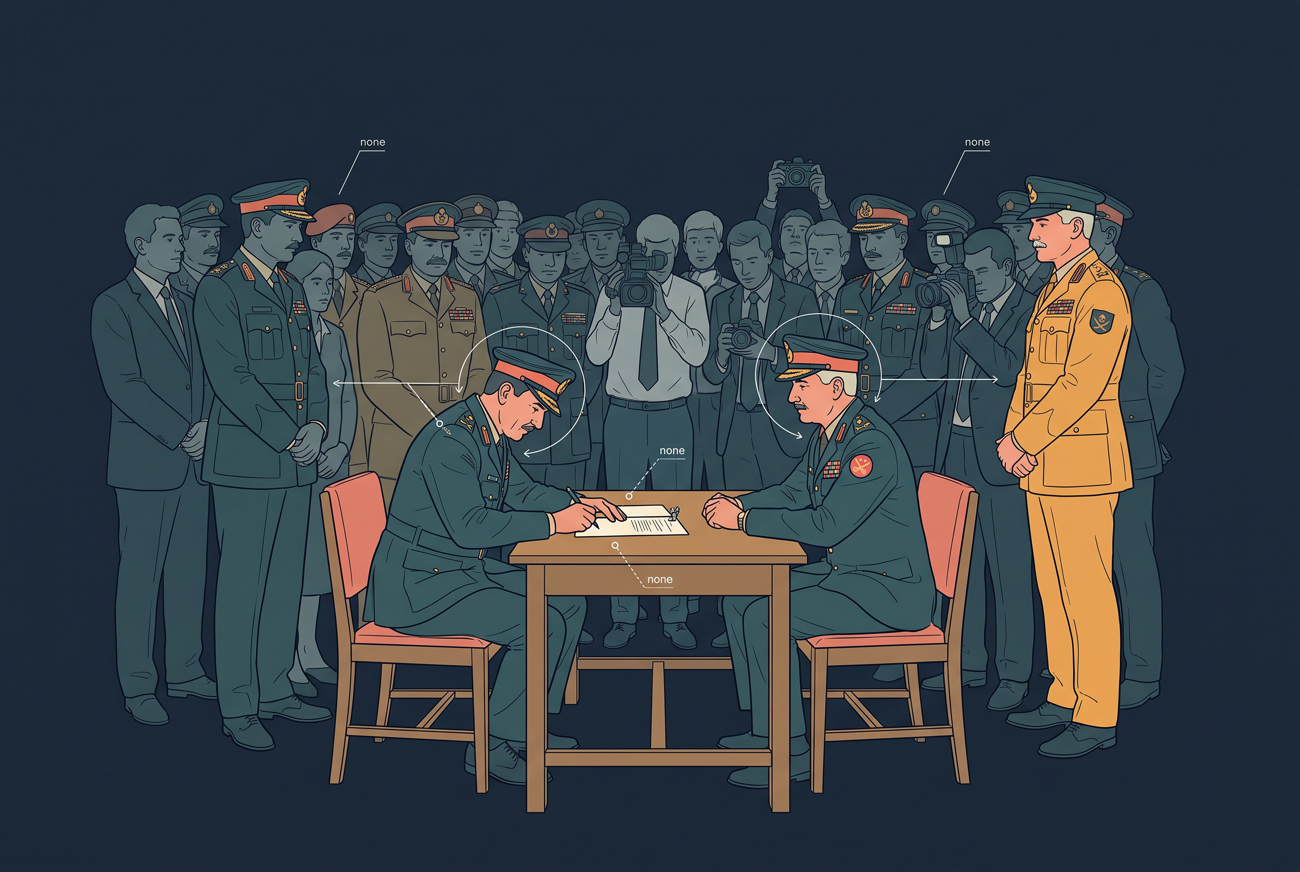
Fig. 5.2 – The Instrument of Surrender at Dacca.
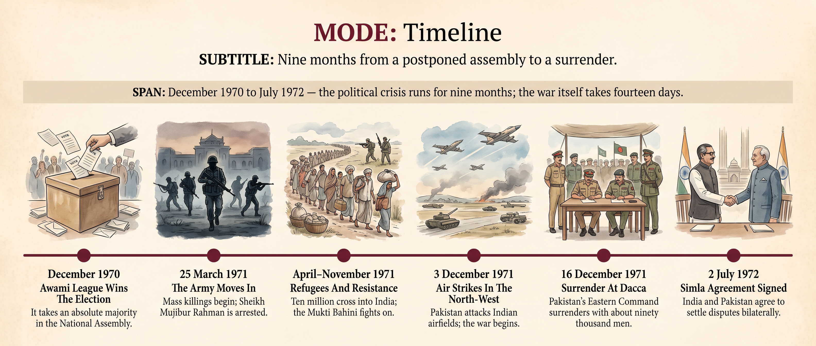
Fig. 5.3 – From An Election To A New State.
5.3.5 The Simla Agreement And Other Consequences
East Pakistan became Bangladesh. Sheikh Mujibur Rahman was released from prison in the west and returned to Dacca in January 1972 to lead it. In Pakistan, Yahya Khan resigned and Zulfikar Ali Bhutto took charge of a state that had lost more than half its population and its eastern territory in a fortnight. For Pakistan the defeat was total, and the theory on which the country had been founded — that shared religion was enough to hold two distant wings together — had failed in front of the world.
India ended the war holding about ninety thousand prisoners and some territory in the west, and it used that position to negotiate rather than to dictate.
What Simla Settled
Indira Gandhi and Zulfikar Ali Bhutto met at Simla and signed an agreement on 2 July 1972. Three things in it mattered.
First, the two countries undertook to settle their differences bilaterally — between themselves, by negotiation, without third parties. For India this was the point of the whole exercise: it moved Kashmir off the international table where it had sat since 1948.
Second, the Ceasefire Line in Jammu and Kashmir was replaced by the Line of Control, drawn where the two armies stood after the ceasefire of 17 December 1971. Neither side was to try to alter it unilaterally, whatever its wider claims.
Third, territories occupied during the war were to be returned, and normal relations — trade, travel, diplomatic missions — restored. The prisoners of war went home under a further agreement in 1973.
What Simla did not do was settle Kashmir. It converted the dispute from an international question into a bilateral one and fixed a line on the ground, but it left the claims themselves exactly where they had been. Pakistan had lost a war and half a country; India had won decisively and gained no territorial settlement of the quarrel that had begun in 1947.
5.4 India And China: From Agreement To Dispute
For most of their history India and China were neighbours who barely touched. Between them lay Tibet — high, thinly peopled and, in practice, running its own affairs. Traders, pilgrims and a handful of officials crossed it. Armies did not.
That arrangement ended within a few years of both countries becoming what they now are. India became independent in 1947. The People’s Republic of China was founded in 1949, after the Communist Party’s victory in the civil war. By the middle of the 1950s the two states had a common frontier for the first time, thousands of kilometres long, and no agreement about where it ran.
5.4.1 Recognition And The Panchsheel Agreement
India recognised the new Chinese government at the very end of 1949, among the first countries outside the communist bloc to do so. Nehru also argued in international forums that the seat China held at the United Nations should belong to the government that actually governed China.
The reasoning behind this was not sentiment. Nehru’s view was that the two largest states in Asia had both emerged from long periods of foreign domination, that neither could afford an arms race with the other, and that Asian countries should not spend their independence acting as instruments of the Cold War powers.
The Agreement Of 1954
That thinking produced an agreement signed at Peking on 29 April 1954. Formally it was a trade agreement — an agreement on trade and intercourse between the Tibet region of China and India. It regulated pilgrim routes, trading marts and border passes, and India gave up the special privileges it had inherited from the British in Tibet: its own trade agencies, its military escorts, and its control of posts and telegraph lines there.
Its preamble set out five principles for relations between the two states, and it is these that are remembered as Panchsheel, the five virtues.
The agreement ran for eight years. The slogan of the period was Hindi-Chini bhai-bhai — Indians and Chinese are brothers — and it was chanted by crowds during the exchange of visits between Nehru and the Chinese Premier, Zhou Enlai, later that year.
That silence is the most important fact about the agreement. India took the passes named in it as confirmation of where the frontier ran. China took the same document as evidence of nothing beyond trade. The two governments had signed a friendship without settling the one question that could destroy it.
5.4.2 The Tibet Issue: Chinese Takeover And The Dalai Lama’s Asylum
China had long claimed authority over Tibet. Britain had recognised something less than that — a suzerainty, under which China handled Tibet’s external affairs while Tibet ran its own government. From 1913 Tibet had in fact acted as an independent state, with its own administration at Lhasa under the Dalai Lama, its spiritual and temporal head.
In October 1950 Chinese forces entered eastern Tibet and defeated the small Tibetan army. India protested at the use of force but did not challenge the claim itself, and in 1951 Tibetan representatives signed an agreement accepting Chinese sovereignty in return for internal autonomy. When India signed the trade agreement of 1954 it described the territory as the Tibet region of China. The buffer was gone.
1959: Revolt And Flight
Autonomy on paper did not survive contact with the reforms pressed on eastern Tibet through the later 1950s. Armed revolt began among the Khampas in the east and spread. In March 1959 it reached Lhasa, where crowds gathered around the Dalai Lama’s palace, and the rising was put down.
On the night of 17 March 1959 the Dalai Lama left Lhasa. He crossed the Himalaya on foot and by pony and entered Indian territory on 31 March. India granted him asylum, housing him first at Mussoorie and later at Dharamsala. Tens of thousands of Tibetans followed him over the next few years.
Nehru’s government drew a careful line. The Dalai Lama could live in India as a religious refugee; he could not set up a government-in-exile or conduct political activity from Indian soil. Beijing did not accept the distinction, and treated the asylum as proof that India was working against Chinese authority in Tibet.
The Frontier Turns Violent
The temperature on the border rose immediately. In August 1959 Chinese and Indian troops clashed at Longju, in the eastern sector. In October, at the Kongka Pass in Ladakh, Chinese forces fired on an Indian police patrol; nine of its men were killed and others were taken prisoner and held for months.
These were small incidents by the standards of what came later. Their importance is that they turned a disagreement between two foreign ministries into a public quarrel that neither government could now settle quietly.
5.4.3 The Border Issue: Aksai Chin And The Eastern Frontier
The frontier between India and China was never a single problem. It was two, at opposite ends of the Himalaya, and they were not alike.
The Western Sector
In the west lay Aksai Chin, adjoining Ladakh. No boundary here had ever been agreed or demarcated. British officials in the nineteenth century had proposed more than one alignment across this plateau and had never settled on one, so India and China could each point to a map with a line drawn by somebody in London or Peking and each could call it the boundary.
What made an argument over an uninhabited plateau urgent was the road. Between 1956 and 1957 China built a highway linking Xinjiang with Tibet, and the shortest route ran across Aksai Chin. For China the road was the only practical land link to western Tibet. For India it was a road built through Indian territory without permission.
The Eastern Sector
In the east the position was reversed. Here India had a line it regarded as settled, the McMahon Line of 1914, and it had an administration and a population in the territory south of it. What it did not have was Chinese agreement that the line existed.
So each side was strong where the other was weak. India held the ground in the east and had only maps in the west; China held the ground in the west and rejected the document on which the east rested.
The Talks That Failed
Through 1958 and 1959 the two governments exchanged long written notes setting out their claims, each citing maps, treaties and the record of past administration. Zhou Enlai came to New Delhi in April 1960 for a week of talks with Nehru.
What was available at those talks, at least by implication, was an exchange: Chinese acceptance of the McMahon Line in the east in return for Indian acceptance of Chinese control of Aksai Chin in the west. It was never put in those words and it was never agreed. Nehru’s position was that a country cannot trade away territory it holds to be its own, and by 1960 Parliament and the press had made any concession politically impossible. The officials of the two sides met afterwards to compare evidence and produced two reports that agreed on almost nothing.
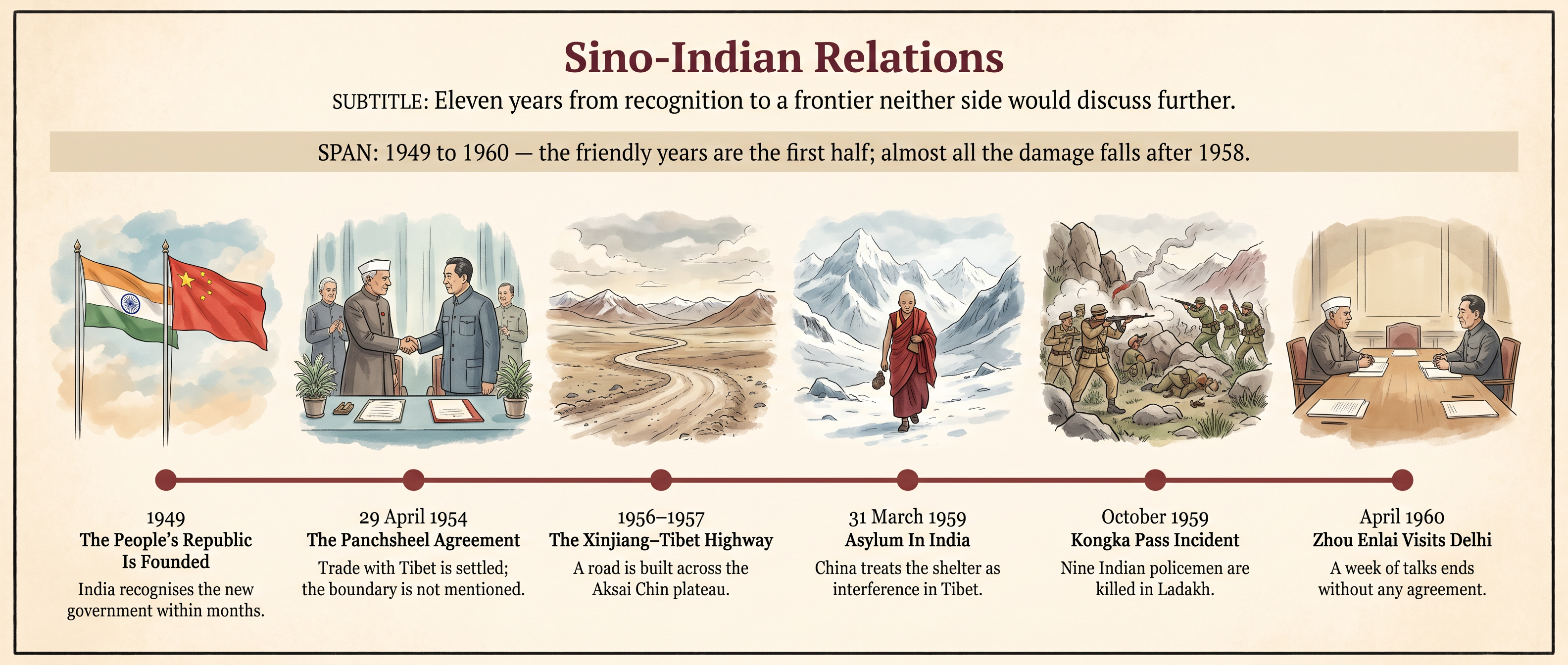
Fig. 5.4 – Friendship And Its Unravelling.
5.5 The Sino-Indian War (1962)
The war of 1962 lasted a month, was fought at heights where breathing itself is difficult, and ended with a ceasefire that China declared by itself. India lost, publicly and badly. The defeat changed Indian defence policy, Indian foreign policy and Indian politics, and its effects run through the rest of this chapter.
5.5.1 Immediate Causes
After the failure of the talks of 1960, both governments began to act on the ground rather than on paper. The Chinese consolidated their hold on Aksai Chin. India adopted what became known as its forward policy.
The idea behind it was to occupy ground before the other side did. From late 1961 the Indian army was ordered to establish small posts — often of only a handful of soldiers — in areas India claimed but did not hold, including places behind Chinese positions. The reasoning was that a physical presence would strengthen India’s claim, and that China, unwilling to risk a war, would not attack them.
Two assumptions sat underneath that reasoning, and both were wrong. The first was that China would not use force. The second was that these posts could be supplied and defended if it did. They could not. Many were far from any road, dependent on air drops, and too small to hold anything.
The Eastern Trigger
The eastern sector produced the flashpoint. In the summer of 1962 an Indian post was set up at Dhola, in an area near the Thag La ridge where the two sides read the McMahon Line differently. Chinese troops moved around it in September. The Indian government ordered that they be evicted, and announced as much publicly, without the forces on the spot being remotely capable of doing it.
5.5.2 The Course Of The War
On 20 October 1962 Chinese forces attacked in both sectors at once — in Ladakh in the west, and in the North-East Frontier Agency in the east. The simultaneity was itself a shock: Indian planning had assumed that any fighting would be local.
In the east the front gave way within days. Tawang was abandoned on 23 October. In the west the isolated posts of the forward policy were overrun one after another, most of them in the first week.
The fighting then stopped for three weeks. China offered talks on the basis that both armies withdraw from the line as it had stood before the fighting, which would have left Aksai Chin in Chinese hands. India refused.
The Second Phase
The attack resumed in the middle of November. In the east it broke through at Se La and Bomdila, and Chinese troops came down to the edge of the Assam plains near Tezpur, with nothing organised standing between them and the Brahmaputra valley. In the west the main weight fell on the approaches to Chushul in Ladakh.
Indian troops were fighting under conditions that made defeat close to certain. Many had been moved from the plains and thrown into action at over four thousand metres without acclimatisation, in cotton clothing, with bolt-action rifles against automatic weapons, at the end of supply lines that were mostly mule tracks and air drops. The air force was not used in support of ground troops. Some units broke; others fought to the end where they stood.
On 21 November 1962 China announced a ceasefire of its own, unasked for and unnegotiated. Its troops then withdrew in the eastern sector to behind the McMahon Line. In the west they stayed where they were, holding Aksai Chin and the ground the forward posts had stood on.
Map
Map 5.5 Caption: The two fronts of October and November 1962, in Ladakh and on the eastern frontier. Brief: Map of the northern frontier showing the full extent of India as officially defined by the Government of India; mark the McMahon Line in the east and the limits of Chinese advance in each sector with dated arrows for the offensives of 20 October and mid-November 1962; label Aksai Chin, Chushul, Rezang La, Thag La, Tawang, Se La, Bomdila and Tezpur; mark with a separate symbol the line to which Chinese forces withdrew in the east after 21 November 1962; state in the key that this shows the position in 1962 and not present-day boundaries.
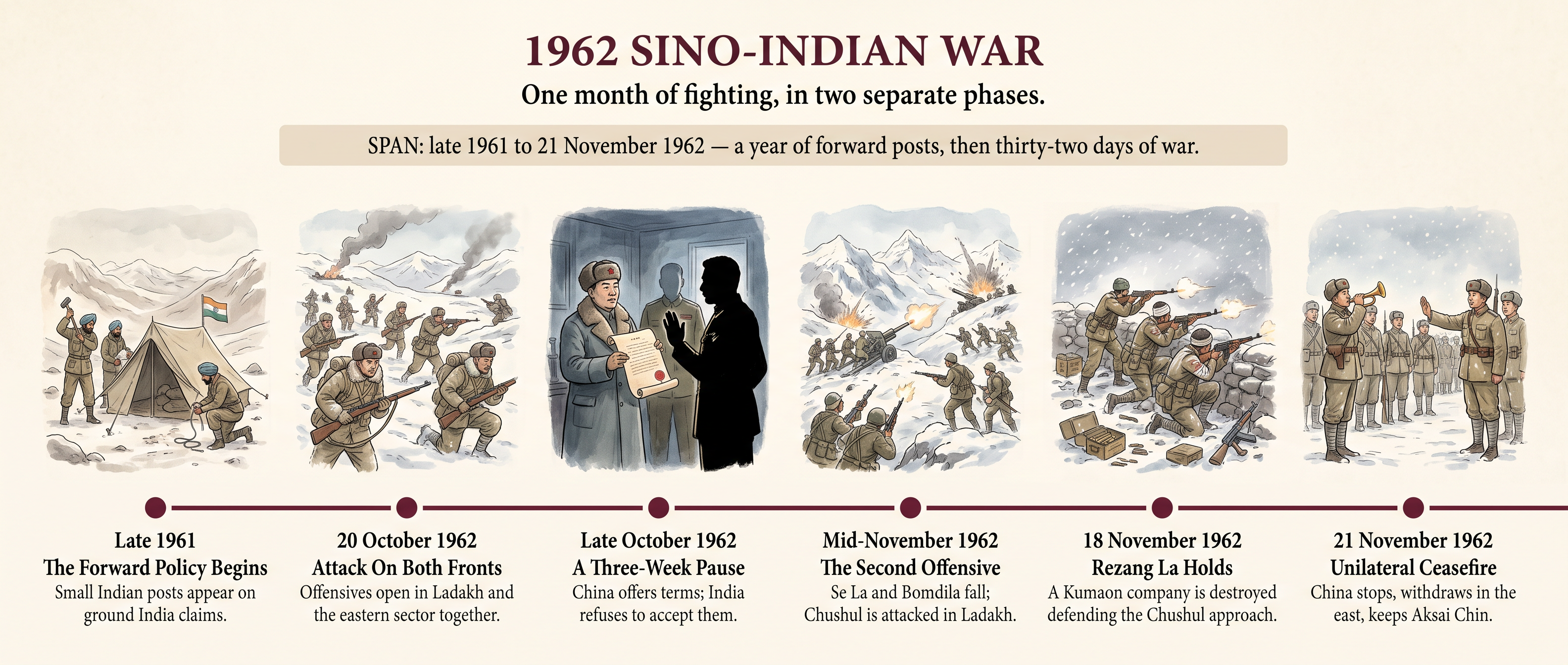
Fig. 5.5 – The War Of 1962.
5.5.3 Consequences Of The War
The war left the border question exactly where it had been, and everything around it altered.
The Military Consequence
India rebuilt its armed forces. The army was expanded and reorganised, mountain divisions were raised and trained for high-altitude war, the air force was enlarged, and roads were pushed up towards the frontier. Defence spending rose sharply and stayed high, which meant less money for everything else at a moment when India could least afford it. The commanders and the Defence Minister of 1962 went; V. K. Krishna Menon resigned in November.
The Political Consequence
The defeat damaged Nehru’s authority at home as nothing before it had, and it destroyed the idea he had built his China policy on — that the two countries would stand together in Asia. He never recovered his old position and died in 1964.
It also produced an act of injustice inside India. Under emergency powers taken in 1962, thousands of Indians of Chinese descent — many of them families settled in Calcutta and Assam for generations — were arrested, interned in a camp at Deoli in Rajasthan, and in many cases deported or pressed to leave. They had nothing to do with the war. Their treatment is part of its history.
The Diplomatic Consequence
India, which had kept clear of military blocs, asked the United States and Britain for arms while the fighting was still on, and afterwards built a long weapons relationship with the Soviet Union. China and Pakistan, each now hostile to India, drew close to one another and settled a boundary agreement between themselves in 1963.
That last consequence takes us back to the beginning of this chapter. A Pakistan encouraged by the sight of an Indian army beaten in the mountains, and newly confident of a great-power friend, was a Pakistan more willing to gamble in Kashmir. Three years after 1962 came 1965.
5.6 Summary
The First War And The Kashmir Question
- When paramountcy lapsed on 15 August 1947, every princely ruler had to accede to India or to Pakistan. Jammu and Kashmir, with a Muslim majority and a Hindu ruler, chose neither and played for time it did not have.
- A revolt in Poonch and a failing supply line weakened Hari Singh’s position before any invasion began. The tribal incursion of 22 October 1947 destroyed what was left of his control.
- India made military help conditional on accession. The Instrument of Accession was signed on 26 October 1947, and Indian troops were flown into Srinagar the next day. Historians still dispute whether the signature preceded the landing.
- Indian forces held the Valley, Jammu and Ladakh; Pakistan held a western strip and the northern areas. By 1948 Pakistan’s regular army was openly in the state and admitted it to the United Nations Commission.
- The United Nations plan ran ceasefire, then withdrawal, then plebiscite. Only the ceasefire happened. Because neither side would withdraw first, the vote was never held — which is why the war settled nothing.
- The consequences were a divided state, an internationalised dispute with an unfulfilled promise attached to it, and two poor states committed to garrisoning a long line in hard country.
The Second War
- By 1965 Pakistan’s leadership believed India was weak: beaten by China in 1962, led by a new and untested Prime Minister, and slow to respond to the clashes in the Rann of Kutch.
- The infiltration across the Ceasefire Line in August 1965 assumed a popular rising in the Valley. Local people reported the infiltrators instead, and the plan collapsed.
- India replied by taking the passes, and then, when Pakistani armour drove at Akhnoor, by crossing the international border towards Lahore and Sialkot. Widening the war was a deliberate choice, and it worked.
- The war ended on 23 September 1965 with neither side ahead. The Tashkent Declaration of 10 January 1966 returned both armies to their pre-war positions.
- Nothing on the map changed; the alignments did. Cut off by their Western suppliers, Pakistan moved towards China and India towards the Soviet Union.
The Third War
- Pakistan’s two wings shared religion and almost nothing else. Power, spending and army command sat in the west; the majority of the population and much of the export earning sat in the east.
- The Awami League’s victory in the election of December 1970 gave the eastern wing the right to govern the whole country. That right was refused, and on 25 March 1971 the army began a crackdown in which very large numbers of civilians were killed.
- About ten million refugees crossed into India. Their return was impossible while the army ruled the east, which turned another country’s political crisis into an Indian emergency.
- India prepared before it acted: sanctuary and training for the Mukti Bahini, a diplomatic campaign abroad, and a treaty with the Soviet Union in August 1971 as cover against China and the United States.
- The war began with Pakistani air strikes on 3 December 1971 and ended with the surrender at Dacca on 16 December. East Pakistan became Bangladesh.
- The Simla Agreement of 2 July 1972 made future dealings bilateral, replaced the Ceasefire Line with the Line of Control, and returned occupied territory. It did not settle Kashmir.
India And China
- India recognised the People’s Republic of China in December 1949 and argued for its place at the United Nations. Nehru’s case was that two large post-colonial Asian states could not afford an armed frontier between them.
- The Panchsheel agreement of April 1954 gave up India’s inherited privileges in Tibet in exchange for trade rights and five principles of coexistence. It said nothing about where the boundary ran, and that silence proved decisive.
- The Dalai Lama’s flight in March 1959 and India’s grant of asylum turned a cooling relationship into a hostile one. India refused to allow a government-in-exile; China regarded the shelter itself as interference.
- The frontier had never been fixed by an agreement both sides accepted. In the west, India’s claim to Aksai Chin rested on inherited British lines while China held the ground and its highway. In the east, India relied on the McMahon Line of 1914, which China rejected because it denied Tibet’s authority to make treaties.
- The talks of 1960 failed because neither leader could concede: no Indian government could give up published territory, and no Chinese government could give up its only land route to Tibet.
The War Of 1962
- India’s forward policy planted small, unsupplied posts on claimed ground, resting on the assumption that China would not fight. Both assumptions in it were wrong.
- The attack of 20 October 1962 came in both sectors at once. After a three-week pause and a rejected offer of terms, a second offensive in November broke through to the edge of the Assam plains.
- Indian troops fought unacclimatised, poorly clothed and poorly armed, at the end of supply lines that were mostly mule tracks. Defeat came from planning, supply and equipment.
- China declared its own ceasefire on 21 November 1962, withdrew behind the McMahon Line in the east, and kept Aksai Chin in the west.
- The consequences were a rebuilt and much costlier military, the collapse of Nehru’s Asian policy and of his political authority, the internment and deportation of thousands of Indians of Chinese descent, and a new closeness between China and Pakistan.
- That closeness, and the sight of a beaten Indian army, fed directly into Pakistan’s calculation in 1965. The chapter’s two quarrels are not separate stories.
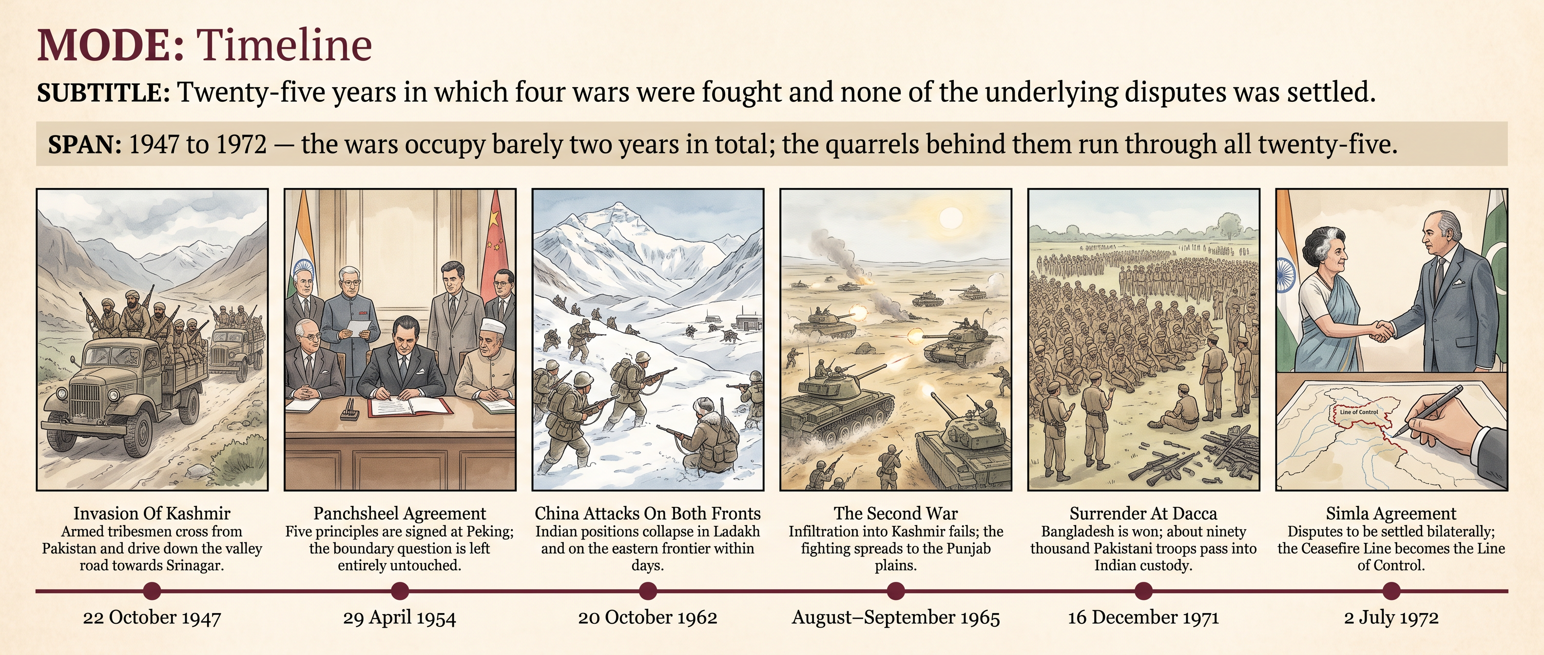
Fig. 5.6 – India’s Foreign Policy, 1947 To 1972.
What The Evidence Cannot Tell Us
Almost everything in this chapter comes from what governments chose to record: treaties, notes, communiqués, army despatches, surrender documents. These are written by the people making the decisions, for the record they intend to leave, and often while the outcome is still uncertain. They are strong evidence of what was agreed and weak evidence of why.
The silences follow from that. We know the number of refugees who registered at a camp in 1971, not the number who never reached one. We know when a line was drawn at Karachi, not what it did to the villages it cut through. Nobody in Aksai Chin was asked, because nobody lived there — and nobody in the Valley, in Poonch or in the eastern wing was asked either, though millions did.
Nor can these papers settle the questions this chapter has left open: whether the accession was signed before the aircraft landed, or whether the war of 1962 was provoked or prepared. Where the decisive conversation was never written down, the historian can set out the readings and weigh them, but cannot close the case.
5.7 Check Your Memory
Why did Maharaja Hari Singh sign the Instrument of Accession on 26 October 1947? Describe briefly what had happened in the four days before he signed it.
The United Nations plan of 1948 for Jammu and Kashmir had three stages. Name them in order, say which of them was actually carried out, and explain why the others were not.
Explain why an agreement signed in 1954 whose first principle was mutual respect for territorial integrity did not prevent a war over territory eight years later.
Reconstruct, step by step, the chain that led from the border clashes in the Rann of Kutch early in 1965 to Indian troops advancing towards Lahore in September of that year. Show at each step what one side concluded from the actions of the other.
Set out in order the developments that carried Pakistan from the general election of December 1970 to India’s entry into the war in December 1971. At which point in that sequence did the crisis become an Indian problem, and why?
Read Source 5.1 again. Choose two of the five principles and explain what each government later said the other had done to break them. Then say what the agreement does not contain, and how that omission made such accusations possible.
Study Fig. 5.2. What does this photograph establish beyond doubt about the war of 1971? Name two things about that war which it cannot show you, and say where a historian would have to look for them instead.
Using Map 5.5, locate Aksai Chin, Tawang, Bomdila and Chushul. Explain why the Chinese forces withdrew in one sector after 21 November 1962 and stayed where they were in the other.
Distinguish the Ceasefire Line of 1949 from the Line of Control of 1972. Explain how each came into being, and state clearly what changed and what did not change when the second replaced the first.
This chapter gives two readings of the war of 1962: that India’s forward policy provoked the attack, and that the Chinese offensive had been prepared in advance and needed only an occasion. Argue each case in turn, using evidence from the chapter, and state what a historian would need to find in order to decide between them.