Chapter 6: Planning And Sustainable Development In Indian Context
The word ‘planning’ is probably already yours. You plan for an exam. You plan a trip to the hills — what to pack, when to leave, how much money to carry. Planning is thinking ahead, fixing on a scheme, and then acting to reach a goal. Now stretch that same habit across a whole country.
At Independence, India made a deliberate choice. It would not leave its development to chance, to the slow hit-and-miss of reform and reconstruction. It would plan — sector by sector, and region by region. For decades a Planning Commission drew these plans; on 1 January 2015 the NITI Aayog took its place, this time pulling the states into the decisions.
But a country does not develop evenly. Some districts surge ahead; others, sometimes resource-rich, still lag behind, because development needs technology, investment and institutions, not resources alone. A planner who ignores this map lets the gap widen. A planner who reads it can steer roads, schools, water and credit toward the places left behind.
And here a harder question waits. When a plan finally transforms a neglected place — turns dry land into cropland, or a cut-off valley into a connected one — it changes the land itself. Can that change last, or does it quietly spend the very resources the next generation will need? This chapter follows planning from the idea to the field, and asks what it costs.
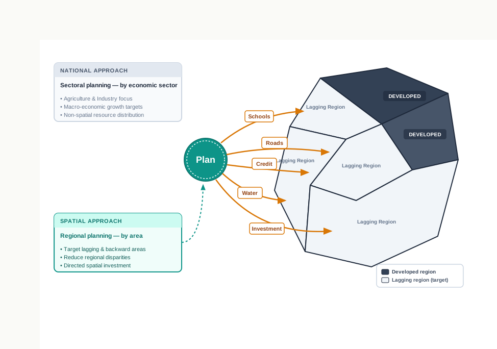
Fig. 6.0 – Steering resources toward lagging areas.
6.1 Approaches To Planning
What Planning Means
You already use the word planning every day. You plan for an exam, or for a trip to the hills — you think ahead, settle on a scheme, and then carry out a set of actions to reach a goal. Planning is exactly that: thinking, forming a programme, and putting it into effect to achieve something you have decided on.
In this chapter the goal is a particular one — economic development. Planned development is unlike the older, hit-and-miss way of improving an economy, in which reforms and reconstruction are tried piece by piece and one hopes they add up. A plan fixes the goal first, then works out the steps to reach it.
India chose this route from Independence. It first adopted centralised planning, then moved to decentralised, multi-level planning that drew the states and districts in. For decades the Planning Commission drew up the plans, working at the Centre, State and district levels. On 1 January 2015 it was replaced by the NITI Aayog, set up to involve the states in making economic policy for India and to give strategic and technical advice to both the Central and the State governments.
Two Ways To Plan
There are, broadly, two approaches, and a country uses both. Sectoral planning organises development by sector of the economy. It draws up sets of schemes and programmes for agriculture, irrigation, manufacturing, power, construction, transport, communication, social infrastructure and services, and pushes each one forward. Its question is: how do we grow this activity, wherever it happens to take place?
Regional planning organises development by area instead. It begins from a plain fact — no country develops evenly over space. Some areas move ahead; others lag behind. This uneven pattern forces planners to take a spatial perspective: to look at the map and draw plans that reduce regional imbalance, the gap in development between one area and another.
The two are not rivals. Sectoral planning builds up the sectors; regional planning makes sure the gains are not bunched into the districts that were already ahead. One thinks in activities, the other in places, and a good plan holds both in view.
The two approaches can be set out as a single branching tree.
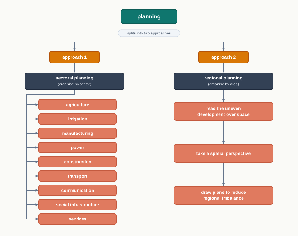
Fig. 6.1 – Sectoral and regional approaches to planning.
6.2 Target Area Planning
Why Some Areas Need Extra Care
Planning has to take special care of areas that have stayed economically backward. You might expect a region’s development to follow its resource base — and often it does. But sometimes a resource-rich region still lags behind, because development needs more than resources. It needs technology, investment and institutions to turn those resources into livelihoods.
After about a decade and a half of planning, it became clear that regional imbalances were not shrinking but widening. To arrest this, the Planning Commission introduced two focused approaches. The target area approach directs help at a backward place — a hill tract, a drought belt, a desert. The target group approach directs help instead at a disadvantaged category of people, wherever they live.
The named examples make the difference concrete. Target-area programmes include the Command Area Development Programme, the Drought Prone Area Development Programme, the Desert Development Programme and the Hill Area Development Programme. The Small Farmers Development Agency (SFDA) and the Marginal Farmers Development Agency (MFDA) are target-group programmes — they reach a class of farmers, not a fixed patch of land. In the 8th Five Year Plan, special area programmes were designed to build infrastructure in hill areas, the north-eastern states, tribal areas and backward areas.
These programmes fall into a clear pattern, which is easiest to see as a branching tree.
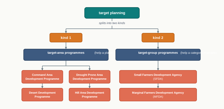
Fig. 6.2 – Target-area and target-group programmes.
6.2.1 Hill Area Development Programme
Hill Area Development Programmes began during the Fifth Five Year Plan, covering 15 districts. These included all the hilly districts of Uttar Pradesh — now the separate state of Uttarakhand in the northern Himalaya — the Mikir Hill and North Cachar hills of Assam in the north-east, the Darjeeling district of West Bengal in the eastern Himalaya, and the Nilgiri district of Tamil Nadu in the Western Ghats of the far south.
In 1981 the National Committee on the Development of Backward Area recommended that all hill areas standing above 600 m — roughly the height at which steep, cool hill conditions begin — and not already covered under a tribal sub-plan be treated as backward hill areas. This gave the programme a clear rule for deciding which land qualified.
The plans were drawn to fit each area’s own topographical, ecological, social and economic conditions, rather than copying a lowland template onto a mountain. The aim was to harness the hill areas’ own indigenous resources through horticulture, plantation, agriculture, animal husbandry, poultry, forestry, and small-scale and village industry — activities that suit a slope and a short growing season rather than fighting against them.
6.2.2 Drought Prone Area Programme
The Drought Prone Area Programme was initiated during the Fourth Five Year Plan. Its twin aims were to provide employment to people in drought-prone areas and to create productive assets there. At first it stressed the construction of labour-intensive civil works — projects that soak up many workers. Later it shifted towards irrigation projects, land development, afforestation and grassland development, and the creation of basic rural infrastructure: electricity, roads, market, credit and services.
When the National Committee on Development of Backward Areas reviewed the programme, it found that the work had stayed largely inside agriculture and its allied sectors, with a major focus on restoring ecological balance. That focus matters because a hard pressure is at work in these areas.
The better strategy, then, is to adopt an integrated watershed development approach at the micro-level — treating a small drainage basin as one unit — and to restore the balance between water, soil, plants, and the human and animal population that all draw on them. That balance should be the basic consideration in any plan for a drought-prone area.
Which Areas Count As Drought-Prone
Two bodies set the boundaries. The Planning Commission of India (1967) identified 67 districts, entire or partly, as prone to drought. The Irrigation Commission (1972) then introduced a sharper test — the 30 per cent irrigated-area line — and used it to demarcate the drought-prone areas, so that an area’s dependence on unreliable rain, rather than a vague impression, decided the matter.
Broadly, India’s drought-prone belt runs through its semi-arid and arid tract — land that is dry but not true desert, where rainfall is low and unreliable. It covers Rajasthan, Gujarat and western Madhya Pradesh in the west, the Marathwada region of interior Maharashtra, the Rayalseema and Telangana plateaus of Andhra Pradesh and the Karnataka plateau and highlands in the Deccan, and the interior parts of Tamil Nadu. This belt can be seen as a single band across the map.
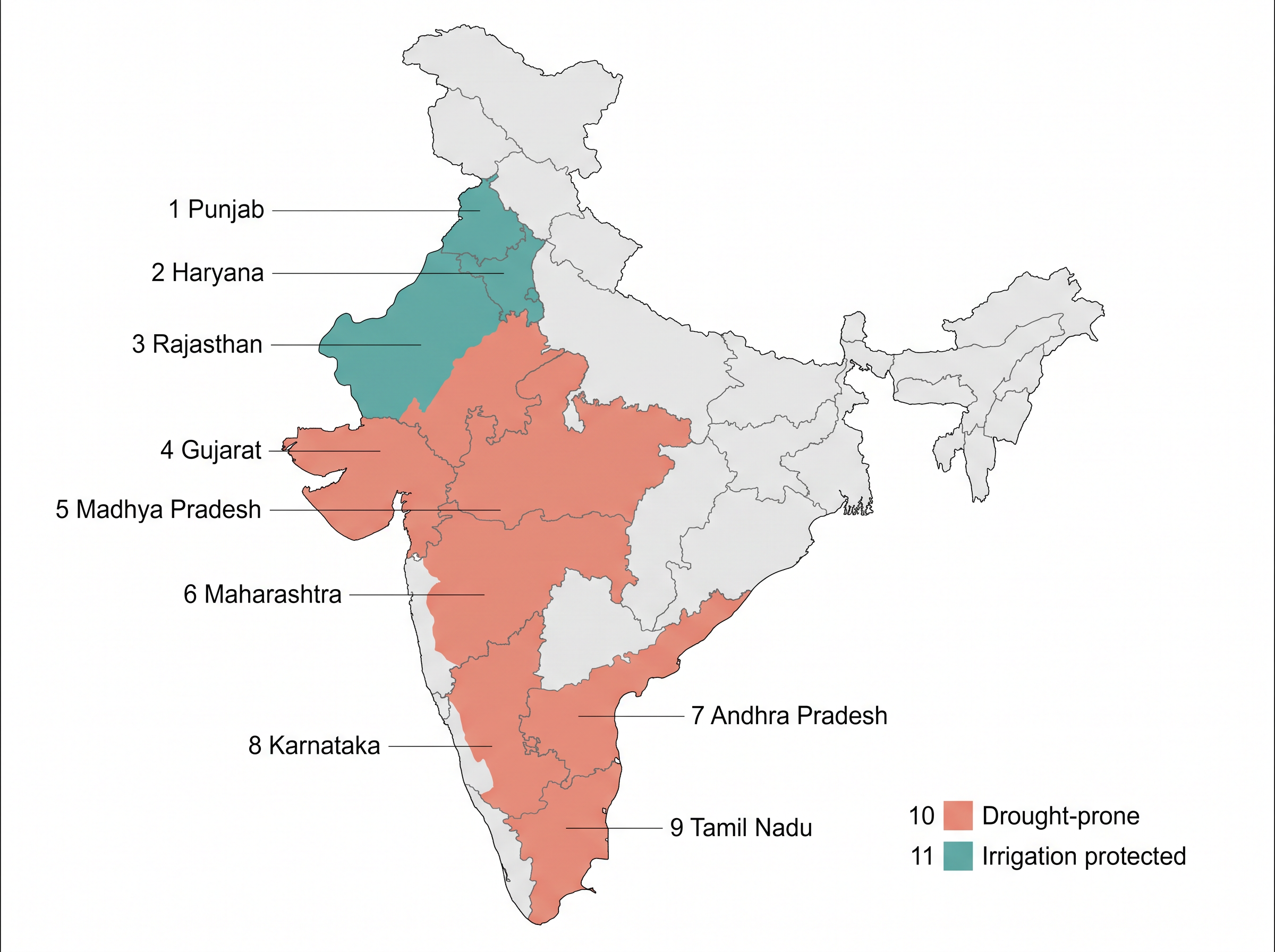
Fig. 6.3 – Drought-prone tracts of India.
Notice what the same map also shows. The drought-prone areas of Punjab, Haryana and north-Rajasthan are now largely protected — not because their climate changed, but because the spread of irrigation reached them. Water, not weather, is what pulls an area out of the drought-prone class.
6.3 Case Study – Integrated Tribal Development Project In Bharmaur Region
The Region And Its People
A case study takes one real place and follows a plan through it, so that a general idea about target-area planning becomes something you can see. Bharmaur is that place. The Bharmaur tribal area lies in the Bharmaur and Holi tehsils of Chamba district, in Himachal Pradesh in the western Himalaya. It was declared a notified — that is, officially recognised — tribal area on 21 November 1975. (The name comes from the Sanskrit Brahmaur; the book keeps the colloquial form Bharmaur.)
Bharmaur is the homeland of the Gaddi, a tribal community that has kept a distinct identity in the Himalaya. The Gaddis long practised transhumance — the seasonal movement of herders and their livestock between lower winter pastures and high summer ones — and speak the Gaddiali dialect. Their economy rests on agriculture and allied activities such as sheep and goat rearing.
The setting is hard. Harsh climate, a low resource base and a fragile environment have shaped the region’s society and economy, leaving it one of the most economically and socially backward parts of Himachal Pradesh. According to the 2011 census, Bharmaur sub-division held 39,113 people — just 21 persons per sq km, meaning barely twenty people share each square kilometre, an extremely thin scatter across the mountains.
Reading The Region On A Map
The four areas, and the rivers that separate them, are clearest on the regional map.
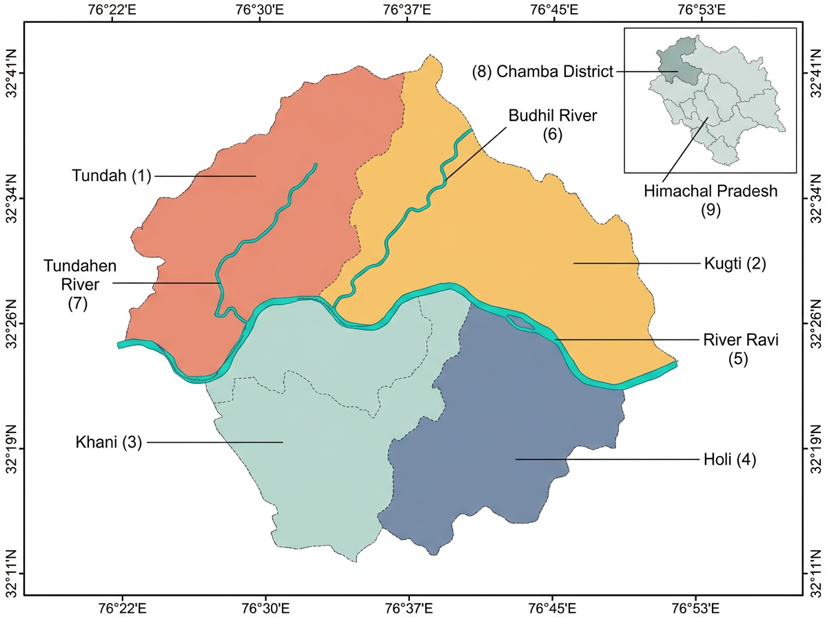
Fig. 6.4 – The Bharmaur tribal region and its four areas.
NCERT’s photographs give a sense of everyday life here — the terraced fields, the settlements and the dress of the Gaddis.
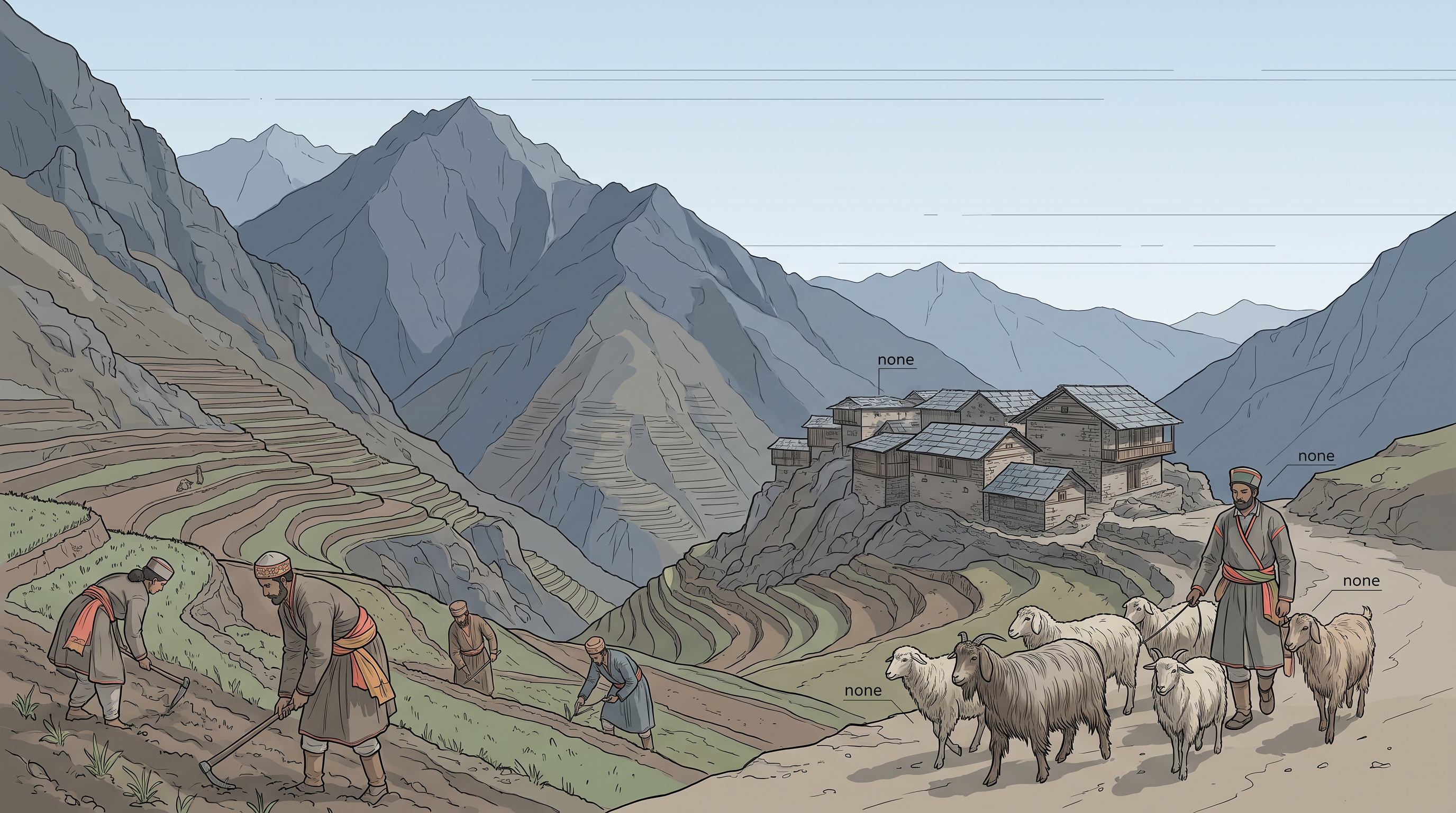
Fig. 6.5 – Everyday life among the Gaddis.
The Project And What It Changed
The development of Bharmaur’s tribal area began in the 1970s, when the Gaddis were included among the scheduled tribes — the communities the Constitution lists for special protection and support. The intervention that followed is the heart of this case.
These figures are more than a report card. A female literacy rate that rose from under 2 per cent to 65 per cent means a whole generation of Gaddi girls reached a classroom their grandmothers never saw. The fall of transhumance to a tenth of households marks a pastoral way of life thinning out — yet the winter migration to Kangra shows the old mobility has not vanished, only turned into wage labour. And the sharpest lesson is in the unevenness: the Ravi-side villages prospered while Tundah and Kugti waited.
The literacy leap is worth seeing on its own.
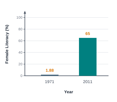
Fig. 6.6 – Female literacy in Bharmaur, 1971 and 2011.
An average that reports ‘Bharmaur has developed’ can quietly hide the village the road never reached — which is why the same project looks different depending on where in it you stand.
6.4 Sustainable Development
What Development Means
We use the word development to describe the state of a society and the process of change it goes through. It is not a single thing. For most of human history, a society’s state was set by the give-and-take between people and their bio-physical environment — the living and physical world around them. How far that interaction could go depended on the society’s level of technology and its institutions, the rules and organisations it built.
Technology and institutions sped up this human–environment interaction, and the momentum they created fed back to push technology and institutions further still. So development is a multi-dimensional concept — it signifies a positive and largely irreversible transformation, a change hard to undo, in the economy, society and environment together.
From Growth To Well-Being
The idea of development is not fixed; it kept changing through the second half of the twentieth century. In the years after the Second World War, development was treated as the same thing as economic growth. Growth was measured by the rise over time in gross national product (GNP) — roughly, the total value of what a country produces — and in per capita income or consumption, the share per person.
But even countries with high economic growth saw poverty rise quickly, because the gains were distributed unequally. Growth was filling the economy, yet not reaching most people. This is the crucial difference between growth and development: growth enlarges the total, while development asks whether ordinary lives actually improve. So in the 1970s, phrases such as ‘redistribution with growth’ and ‘growth and equity’ entered the definition — the point was to spread the gains, not merely to swell them.
Working through questions of redistribution and equity, thinkers realised development could not be confined to the economic sphere at all. It also meant improving people’s well-being and living standards, giving them health, education and equality of opportunity, and securing their political and civil rights. By the 1980s, development had come to mean widespread improvement in the social as well as the material well-being of everyone in a society.
The Rise Of Sustainability
A second concern was rising at the same time. From the late 1960s, awareness of environmental issues grew in the Western world, reflecting a worry that industrial development was harming the environment. Two publications sharpened the fear — ‘The Population Bomb’ by Ehrlich in 1968 and ‘The Limits to Growth’ by Meadows and others in 1972. Together they set the scene for a new model of development gathered under the phrase sustainable development.
Responding to this growing world opinion, the United Nations set up a World Commission on Environment and Development (WCED), chaired by the Norwegian Prime Minister Gro Harlem Brundtland. In 1987 the Commission published its report — the Brundtland Report — entitled ‘Our Common Future’. It defined sustainable development as ‘development that meets the needs of the present without compromising the ability of future generations to meet their own needs.’
The whole arc — from growth to well-being to sustainability — can be followed as a single chain.
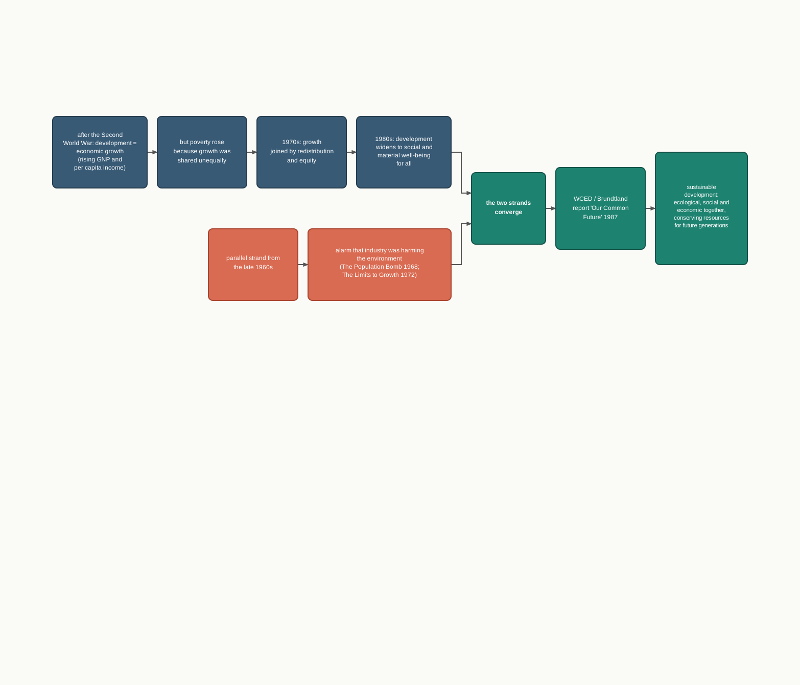
Fig. 6.7 – The evolution of sustainable development.
Sustainable development, then, takes care of the ecological, social and economic sides of development in the present, while pleading for the conservation of resources so that future generations can use them too. It looks past any one country to the development of all humankind, who share a common future.
6.5 Case Study – Indira Gandhi Canal (Nahar) Command Area
A Canal Across A Desert
If Bharmaur showed planning reaching into the mountains, the Indira Gandhi Canal shows it reaching into the desert. It is one of the largest canal systems in India, and its story is the clearest test in this chapter of whether a great transformation can also be a sustainable one.
The whole system, and the command area it was built to water, can be traced on the map.
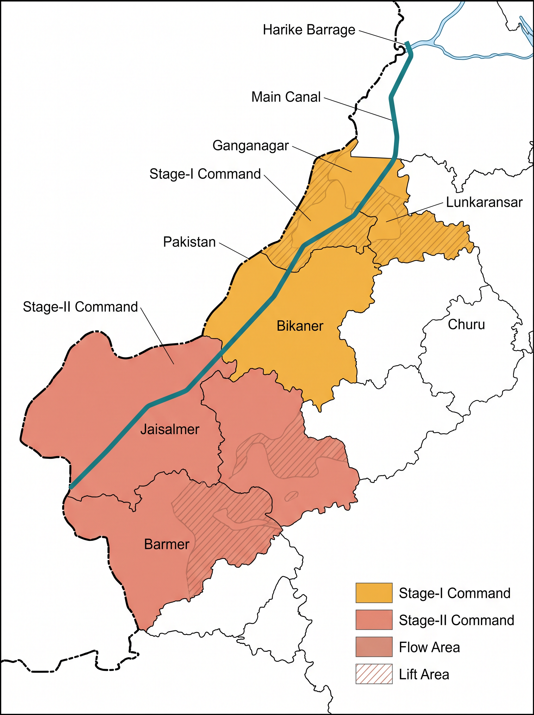
Fig. 6.8 – The Indira Gandhi Canal command area.
The command area is the stretch of land a canal is designed to irrigate. The heart of this case is what the canal did to that land — and here the figures matter.
The scale is the point. A single planned system, 9,060 km long, set out to green nearly 20 lakh hectares of desert — most of it by gravity flow, a costlier minority lifted uphill against the slope. Turning the Marusthali into cropland is an extraordinary feat of planning. But watering a desert this hard changes it in ways no one fully controls, which is why the same canal that made the land bloom also began to spoil it.
What The Water Changed
Irrigation reached Stage-I in the early 1960s and Stage-II only in the mid-1980s. Wherever it arrived, canal water transformed the region’s ecology, economy and society at once — and it did so both for good and for ill.
On the positive side, soil moisture was now available for far longer, and afforestation and pasture-development programmes under the Command Area Development (CAD) effort greened the land. That greening, in turn, cut down wind erosion and reduced the silting-up of the canals themselves. But the negative side arrived with the same water. Intensive irrigation and excessive use of water brought a twin problem — waterlogging, where the water table rises until roots stay drowned, and soil salinity, where salts gather in the soil and poison it for crops.
The farm economy changed just as sharply, because soil moisture had always been the one thing holding cultivation back. Once water spread, both the cultivated area and the intensity of cropping rose. The old desert crops — gram, bajra and jowar, all suited to little water — gave way to thirsty wheat, cotton, groundnut and rice. This intensive irrigation, at first, drove a tremendous rise in agricultural and livestock productivity. Yet the same intensity fed the waterlogging and salinity that, over the long run, undermine the very farming they were meant to support.
NCERT’s photographs capture both faces of the project — the canal in the desert, and the greening it brought alongside.
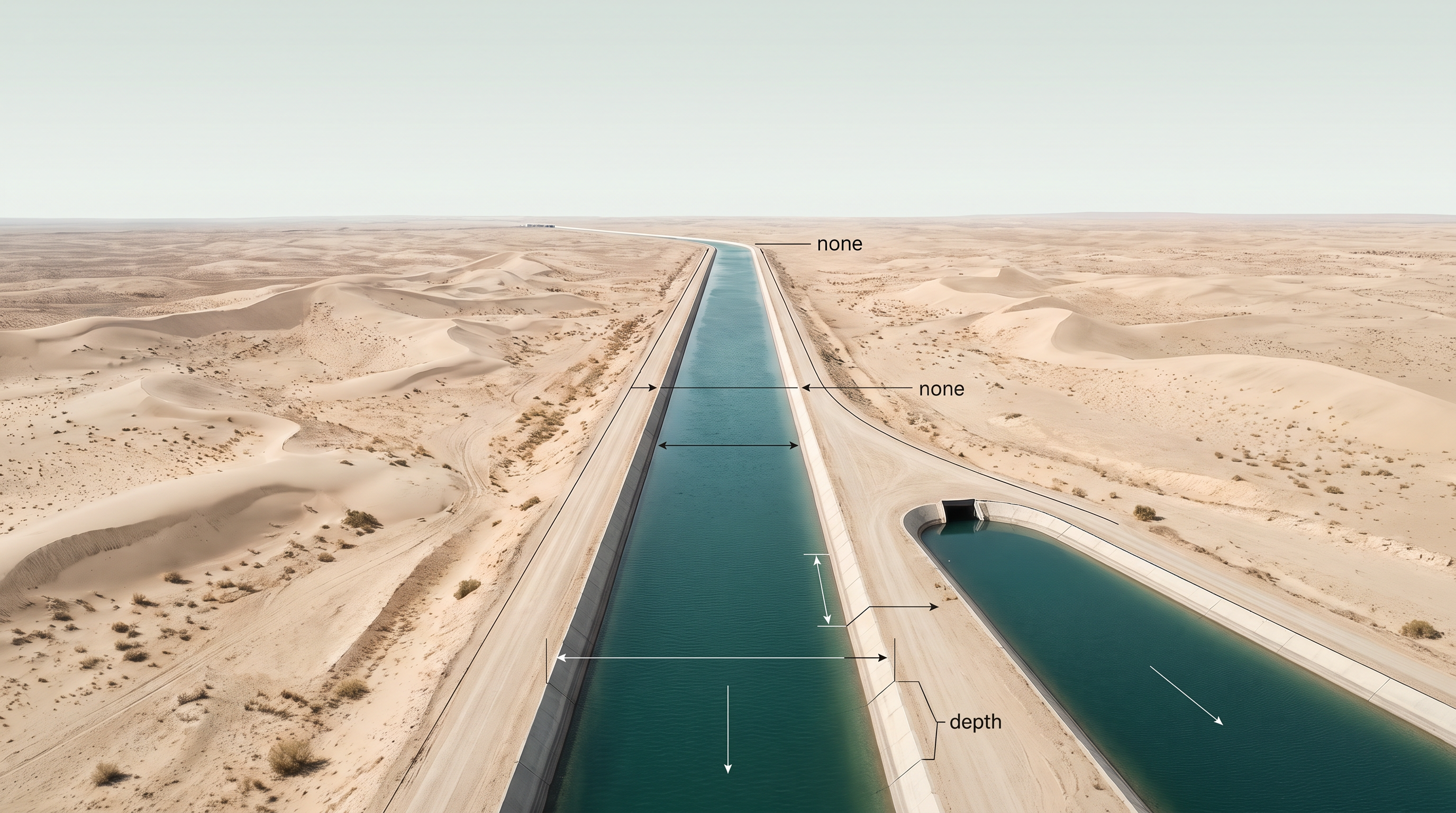
Fig. 6.9 – The Indira Gandhi Canal in the Thar desert.
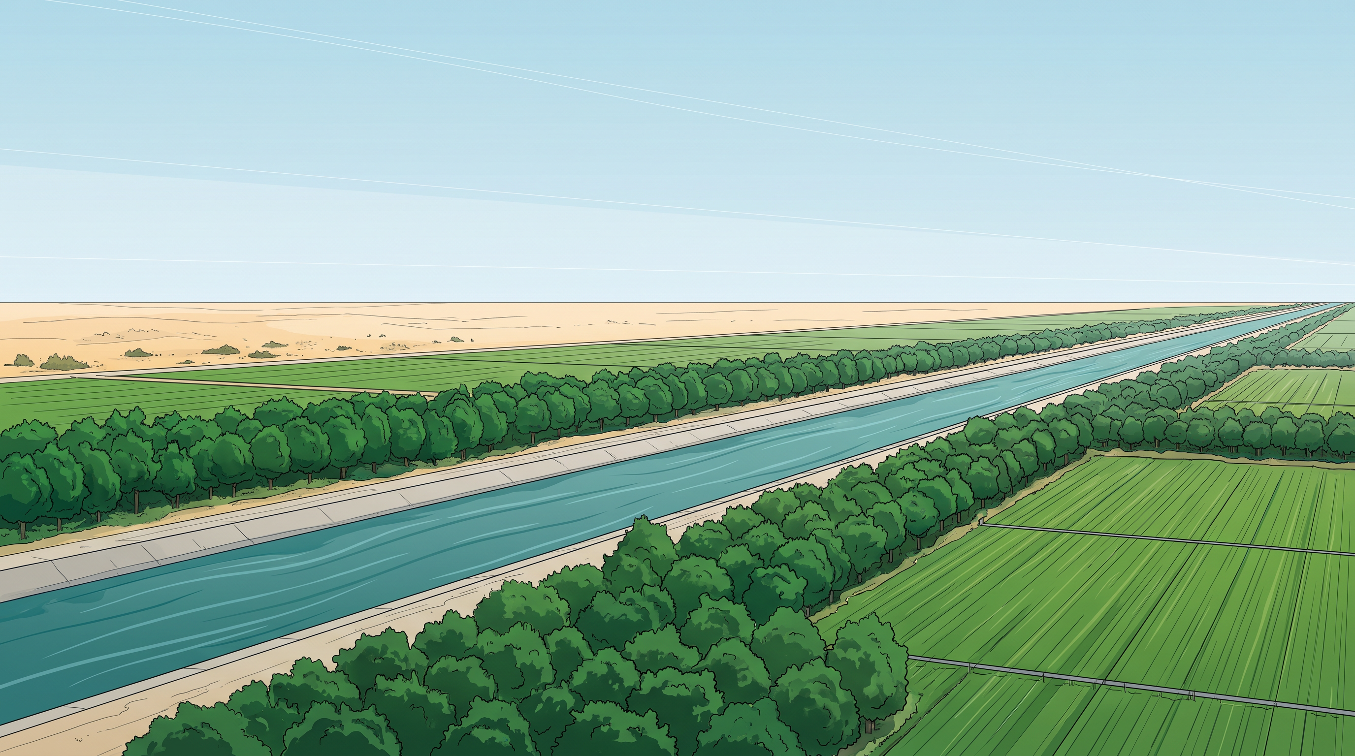
Fig. 6.10 – Afforestation along the Indira Gandhi Canal.
6.5.1 Measures For Promotion Of Sustainable Development
Several scholars have questioned whether the Indira Gandhi Canal Project is ecologically sustainable at all — and the course of the last four decades, with its degradation of the physical environment, has largely proved them right. Attaining sustainable development in the command area therefore demands a major thrust on ecological measures. That is why five of the seven proposed measures are aimed squarely at restoring ecological balance.
The five ecological measures work on water and land together. First, a water-management policy must be strictly enforced: the project envisages protective irrigation — spreading limited water thinly to shield crops from failure — in Stage-I, and more extensive irrigation of crops with pasture development in Stage-II. Second, the cropping pattern should keep out water-intensive crops, be firmly adhered to, and lean instead towards plantation crops such as citrus fruits. Third, the CAD programmes — lining the water courses, developing and levelling the land, and running the warabandi system, which distributes canal water equally among the users of an outlet by fixed turns — must be carried out well, so that less water is lost in conveyance. Fourth, the land already ruined by waterlogging and soil salinity must be reclaimed. Fifth, eco-development through afforestation, shelterbelt plantation — rows of trees that break the wind — and pasture development is needed above all in the fragile environment of Stage-II.
The remaining two measures reach beyond ecology. Social sustainability can be achieved only if land allottees from poor economic backgrounds are given enough financial and institutional support to actually cultivate their land. And economic sustainability cannot rest on agriculture and animal husbandry alone; these allied activities must grow alongside other sectors of the economy, diversifying the economic base and building functional linkages between basic villages, agro-service centres and market centres.
The seven measures fall into three groups, which is easiest to hold together as a single tree.
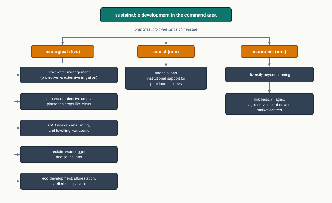
Fig. 6.11 – Measures for sustainability in the command area.
The debate here is not really about whether the canal helped — it plainly did — but about who carries its costs, and whether those costs can be undone.
6.6 Summary
- Planning means thinking ahead, fixing a scheme, and acting to reach a goal. Here it means deliberate economic development, unlike the older hit-and-miss way of reform and reconstruction.
- India planned its development from Independence, moving from centralised to decentralised, multi-level planning. The Planning Commission drew the plans until 1 January 2015, when the NITI Aayog replaced it.
- Planning runs on two approaches. Sectoral planning develops the economy by sector; regional planning develops it by area, taking a spatial view to reduce regional imbalance.
- Some areas stay backward even when resource-rich, because development also needs technology, investment and institutions. This led to target-area planning (help a place) and target-group planning (help a category of people).
- Target-area programmes include the Command Area, Drought Prone Area, Desert, and Hill Area Development Programmes; the SFDA and MFDA are target-group programmes.
- The Hill Area Development Programme began in the Fifth Five Year Plan, covering 15 districts; hill land above 600 m, outside tribal sub-plans, was treated as backward.
- The Drought Prone Area Programme began in the Fourth Five Year Plan. The Planning Commission (1967) named 67 drought-prone districts, and the Irrigation Commission (1972) used a 30 per cent irrigated-area line to demarcate them.
- The drought-prone belt runs through India’s semi-arid and arid tract; areas reached by irrigation, like Punjab, Haryana and north-Rajasthan, are now largely protected.
- Bharmaur, a Gaddi tribal region cut off by mountains, was made an Integrated Tribal Development Project under a 1974 tribal sub-plan. It gained infrastructure and a huge literacy rise, though the benefit reached its four areas unevenly.
- The idea of development widened over time — from economic growth, to growth with equity, to broad well-being, and finally to sustainable development, defined by the Brundtland Report ‘Our Common Future’ (1987) as meeting present needs without compromising future generations.
- The Indira Gandhi Canal turned Thar desert into cropland across a 19.63 lakh hectare command area, greening the land but also bringing waterlogging and soil salinity.
- To sustain the command area, seven measures are proposed — five ecological, one social and one economic — because a transformation this large must be ecologically, socially and economically sustainable to last.
The whole chapter connects into a single chain, from an uneven map to the idea of sustainability.
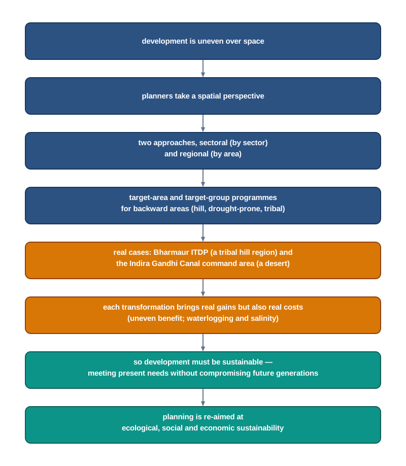
Fig. 6.12 – Chapter overview: from planning to sustainability.
What This Chapter Cannot Tell You
The chapter works through two case regions, not a survey — two examples cannot prove that every programme succeeds, or fails, in the same way. Its figures are also tied to their dates, such as the 2011 census, and say nothing about how these regions stand today. And an average, whether for Bharmaur or for the command area, can hide the village the road never reached or the field the salt has already claimed; it also lists measures that were proposed, without telling us whether they were carried out or whether they worked.
6.7 NCERT Questions
- Regional planning relates to:
- Development of various sectors of economy.
- Area specific approach of development.
- Area differences in transportation network.
- Development of rural areas.
- ITDP refers to which one of the following?
- Integrated Tourism Development Programme
- Integrated Travel Development Programme
- Integrated Tribal Development Programme
- Integrated Transport Development Programme
- Which one of the following is the most crucial factor for sustainable development in Indira Gandhi Canal Command Area?
- Agricultural development
- Eco-development
- Transport development
- Colonisation of land
- What are the social benefits of ITDP in the Bharmaur tribal region? (30 words)
- Define the concept of sustainable development. (30 words)
- What are the positive impacts of irrigation on Indira Gandhi Canal Command Area? (30 words)
- Write short notes on drought-prone area programme. How does this programme help in the development of dryland agriculture in India? (150 words)
- Suggest the measures of promotion of sustainability in Indira Gandhi Canal Command Area. (150 words)
6.8 Check Your Concepts
- Distinguish between sectoral planning and regional planning. What does each one organise development around?
- What is the difference between the target-area approach and the target-group approach to planning? Give one example of each from the chapter.
- The Hill Area Development Programme treated some hill land as backward. State the height above which land qualified, and name the Five Year Plan in which the programme began.
- Using Fig. 6.8, name the districts that lie in Stage-I of the Indira Gandhi Canal command area, and explain the difference between the canal’s flow channels and its lift canals.
- The Indira Gandhi Canal’s culturable command area is 19.63 lakh hectares, of which about 70 per cent was to be irrigated by flow. Using only these figures, work out roughly how many lakh hectares were to be watered by flow, and how many by lift.
- Why are the drought-prone areas of Punjab, Haryana and north-Rajasthan now largely protected, while much of the rest of the semi-arid belt is not?
- Irrigation brought clear gains to the Indira Gandhi Canal command area, but also two serious problems. Name the two problems, and explain as a chain how intensive irrigation produced them.
- In Bharmaur, female literacy rose from 1.88 per cent in 1971 to 65 per cent in 2011. What does this single regional figure not tell you about how development was shared within Bharmaur?