Chapter 3: Interior Of The Earth
No one has ever stood at the centre of the Earth, and no one ever will. The planet’s radius is about 6,378 kilometres, yet the deepest that human beings have managed to dig reaches only a dozen kilometres down — barely a scratch on the skin of an apple. Below that, the rock grows too hot and the pressure too crushing for any drill to follow. So the entire interior, thousands of kilometres of it, lies permanently beyond the reach of our eyes and our instruments.
And yet a geographer can tell you, with confidence, that far beneath your feet the material is denser than the rock at the surface, that one deep layer behaves like a liquid, and that the very heart of the planet is solid metal. How can anyone be so sure about a place no human has seen?
The answer travels through the ground itself. Every large earthquake releases a burst of energy that spreads outward as waves, racing through the whole body of the planet and out to recording stations on the far side of the world. Those waves speed up, slow down, bend, and sometimes vanish entirely, depending on what they pass through. By reading their arrivals — and, stranger still, their silences — scientists have mapped a world no drill will ever reach. This chapter is the story of how the shaking Earth gives up the secret of its own inside.
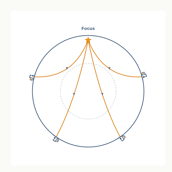
Fig. 3.0 – Earthquake waves travelling through the Earth.
This chapter will let you answer each of these for yourself.
3.1 Introduction
A Planet We Cannot Reach
What is the Earth actually like on the inside? You might picture it as a solid ball, like a cricket ball right through. Or you might picture a hollow ball wrapped in a thick shell of rock — the lithosphere, the solid, rocky outer skin of the planet. Perhaps you have seen footage of a volcanic eruption: hot molten lava, dust, smoke and fire, with magma — molten rock from deep inside the Earth — pouring out of the crater.
These glimpses are tempting, but they remain only glimpses. The truth is that no one has ever reached the interior of the Earth, and no one can. We are left to understand it through indirect evidence alone — by studying the signals that travel out from the inside, rather than by going in ourselves.
Why The Inside Shapes The Surface
This hidden interior is not a separate world locked away below. The shape of the land at the surface is largely the product of forces working deep inside the planet. Two families of forces are always acting on the landscape. Endogenic processes are driven by the Earth’s internal heat and pressure; they build the land up and deform the crust. Exogenic processes act from the outside — running water, wind, ice and weathering — and they wear the land down.
You cannot fully read the physiography of a region — its physical form and features — while ignoring the endogenic forces beneath it. And this is not an abstract point. Human life is closely shaped by the physiography around it: where people can farm, settle, build and travel all depend on the lie of the land. So it is worth getting to know the forces that develop a landscape. To understand why the ground suddenly shakes, or how a tsunami — a great wave that races across the sea — is set off, we first need to know something about the world beneath the crust.
What This Chapter Sets Out To Do
In the previous class you saw that the Earth is not uniform: its materials are arranged in layers, from the thin crust at the outside to the core at the centre, rather like the layers of an onion. What remains is to ask how scientists ever worked out those layers at all, and what each one is like. That is exactly the task of this chapter — to show how a planet no one can enter has, all the same, been read from the inside out.
3.2 Sources Of Information About The Interior
The Earth’s radius is about 6,378 km. That is the distance from the surface down to the centre, and no one can travel it: we cannot reach the centre to make observations or to bring back samples. So most of what we know about the interior is built from estimates and careful inference rather than from direct measurement. Even so, a part of the information does come from direct observation and the analysis of real material. Geographers sort these into direct sources and indirect sources.
3.2.1 Direct Sources
The most easily available direct evidence is solid earth material itself — the rock at the surface, and the rock brought up from mines. The gold mines of South Africa, in the far south of the African continent, reach depths of 3 to 4 km, among the deepest workings anywhere. Going deeper than this is not possible, because the rock at such depths is simply too hot to work in.
To reach further, scientists have set up projects that drill into the crust and pull up material for study. Two of the largest are the Deep Ocean Drilling Project and the Integrated Ocean Drilling Project. The deepest borehole so far, at Kola in the Arctic, has reached about 12 km. Set against the 6,378 km to the centre, that is a tiny fraction — yet the material recovered from these depths has taught us a great deal, because every sample can be analysed directly in a laboratory.
A volcanic eruption offers a second direct source. When magma is thrown out onto the surface during an eruption, material that was hidden below suddenly becomes available for laboratory analysis. There is a catch, though: it is very hard to tell from what depth the erupted magma originally came, so this evidence cannot easily be pinned to a particular layer.
3.2.2 Indirect Sources
Most of our knowledge, though, comes indirectly — from studying the properties of matter and reasoning back to the conditions inside. Mining has already shown us that both temperature and pressure rise as we go deeper, and that the density of the material rises with depth as well. Because we can measure the rate at which these change, and we know the total thickness of the Earth, scientists have been able to estimate the temperature, pressure and density expected at each depth. The details for each layer come later in this chapter.
Clues From Meteors
Another indirect source arrives from space. Meteors are pieces of rock and metal that sometimes fall to the Earth. The material they carry is not from the Earth’s own interior — but a meteor is a solid body formed from much the same materials as our planet, so its make-up and structure give a useful second opinion on what the deep Earth is likely to be made of.
Gravity And Magnetism
The pull of gravity is not the same everywhere on the surface. The gravitational force, written g, is stronger near the poles and weaker at the equator. The reason is shape: the equator sits farther from the centre of the Earth than the poles do, and a greater distance means a weaker pull. Gravity also varies with the mass of material below a place — where mass is unevenly distributed, the reading shifts. When the measured value at a place differs from the value we expected, that difference is called a gravity anomaly. Such anomalies are useful because they reveal how mass is distributed within the crust. In much the same way, magnetic surveys map the distribution of magnetic materials in the crust, and so tell us how material is arranged there.
The last indirect source is the most powerful of all: seismic activity, the study of the waves set off by earthquakes. Because it gives the fullest picture of the layered interior, it is worth looking at in some detail.
3.2.3 Earthquake
An earthquake, in plain terms, is a shaking of the ground. It is a natural event, caused by a sudden release of energy that sends waves travelling outward in every direction. Because those waves pass right through the planet, the study of them gives us the most complete picture we have of the layered interior.
3.2.3.1 Why Does The Earth Shake?
The energy is released along a fault — a sharp break in the rocks of the crust. The blocks of rock on either side of a fault tend to move in opposite directions. But the weight of the overlying rock presses them together, and friction locks them in place, so for a long time nothing moves and stress keeps building.
Eventually the tendency of the blocks to move apart overcomes the friction holding them. The locked blocks, bent and deformed by the strain, suddenly slip past one another. That abrupt slip releases the stored energy, and the energy travels out as waves in all directions.
The exact spot where the energy is released, below the surface, is the focus, also called the hypocentre. The waves spread out from the focus and reach the surface. The point on the surface directly above the focus — the nearest surface point to it — is the epicentre, and it is the first place to feel the waves.
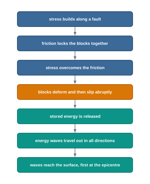
Fig. 3.1 – The release of earthquake energy along a fault.
3.2.4 Earthquake Waves
All natural earthquakes happen within the lithosphere, which here reaches down to about 200 km from the surface. The instrument that records the waves as they arrive is called a seismograph. The record it draws is a curve, shown in Fig. 3.2, and that curve has three distinct parts — one for each kind of wave that arrives, in the order it arrives.
Earthquake waves come in two broad families. Body waves are generated by the release of energy at the focus and travel through the body of the Earth — which is exactly where their name comes from. When these body waves reach the surface rocks, they set off a second family, the surface waves, which travel along the surface itself. The speed of any of these waves is not fixed: it changes with the material they pass through. The denser the material, the faster the wave goes. Their direction changes too, for waves bend or bounce whenever they cross from one material into another of different density.
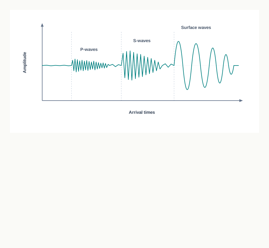
Fig. 3.2 – Seismograph record of earthquake waves.
Two Body Waves, Two Behaviours
There are two kinds of body wave, called P-waves and S-waves. P-waves travel faster and so are the first to arrive at the surface; for this reason they are also called primary waves. They behave much like sound waves, and, importantly, they can pass through gases, liquids and solids alike. S-waves arrive a little later, which is why they are called secondary waves. Their crucial property is that they travel only through solids — they cannot pass through a liquid or a gas at all. This single fact has been enormously useful: by seeing where S-waves can and cannot go, scientists have worked out the structure of the interior.
When waves cross a boundary between different materials, some rebound — that is reflection — while others bend and change direction — that is refraction. These changes in direction are read off the seismograph record and used to map what lies below. Last of all to be recorded are the surface waves. They are the most destructive of the three: they displace rock at the surface, and it is largely their shaking that brings buildings and other structures down.
3.2.4.1 Propagation Of Earthquake Waves
Different waves move the rock in different ways as they pass through it. A P-wave vibrates back and forth along the same line in which the wave is travelling. This pushing and pulling squeezes and stretches the rock, creating alternating patches of denser and looser material along the wave’s path. The remaining waves vibrate at right angles to the direction of travel instead. An S-wave, in particular, vibrates at right angles to its direction of motion, in the vertical plane, so it throws the rock into troughs and crests as it passes. Surface waves, which combine these motions at the surface, are considered the most damaging of all.
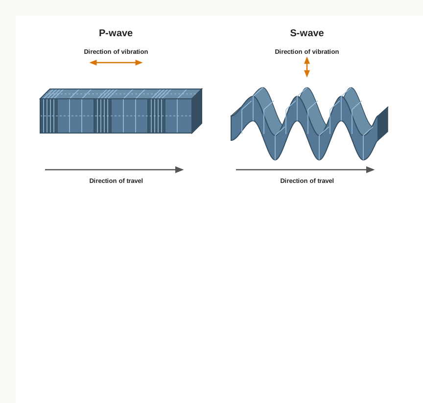
Fig. 3.3 – Propagation of (a) P-waves and (b) S-waves.
3.2.4.2 Emergence Of Shadow Zone
When an earthquake strikes, its waves are picked up by seismographs at far-off locations around the globe. Yet there are certain areas where the waves never arrive at all. Such an area is called a shadow zone. Every earthquake produces its own shadow zone, in a different place, depending on where the quake happened.
The shape of these zones is precise, and it is measured as an angle around the Earth from the epicentre. Seismographs lying within 105° of the epicentre record both P-waves and S-waves. Seismographs beyond 145° record P-waves, but no S-waves. The band lying between 105° and 145° from the epicentre receives neither, and so it is the shadow zone for both kinds of wave. Beyond 105°, however, the whole region fails to receive S-waves.
This makes the S-wave shadow zone far larger than the P-wave shadow zone. The P-wave shadow zone is only a band circling the Earth between 105° and 145°; the S-wave shadow zone, by contrast, covers a little over 40 per cent of the Earth’s surface. Once you know where the epicentre of an earthquake lies, you can work out its shadow zone for yourself.
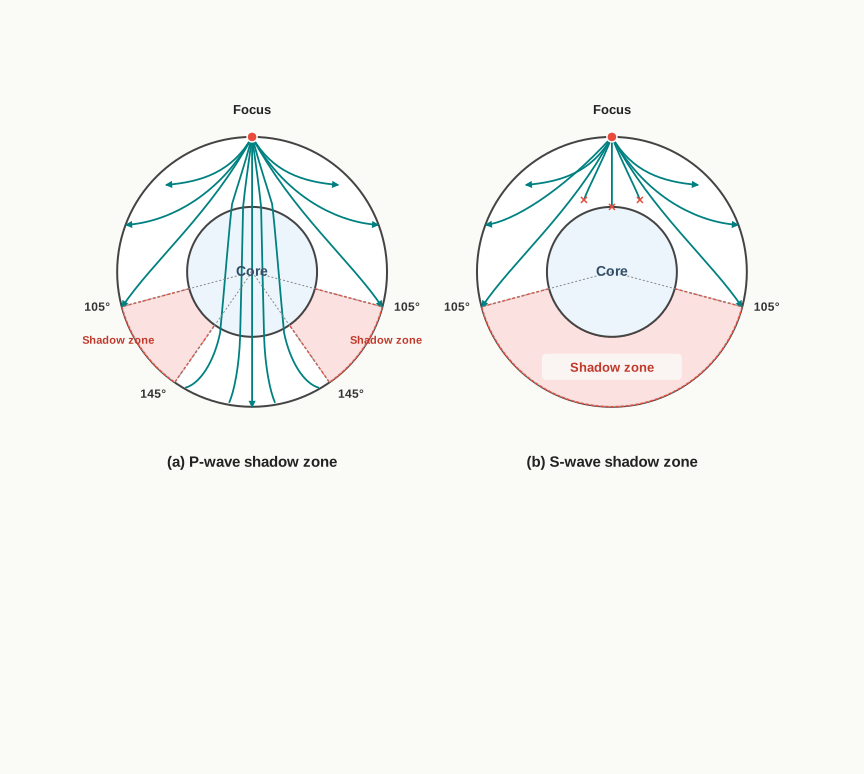
Fig. 3.4 – The shadow zones of (a) P-waves and (b) S-waves.
3.2.4.3 Types Of Earthquakes
Earthquakes are grouped by their cause. The most common are tectonic earthquakes, produced by the sliding of rocks along a fault plane — the mechanism described above. A special class of tectonic earthquake is the volcanic earthquake, which is confined to areas of active volcanoes. In regions of heavy mining, the roofs of underground mines sometimes cave in, producing minor tremors known as collapse earthquakes. The explosion of chemical or nuclear devices can shake the ground as well, giving explosion earthquakes. Finally, earthquakes that occur in the area of a large reservoir — the great body of water held back behind a dam — are called reservoir induced earthquakes.
3.2.4.4 Measuring Earthquakes
An earthquake can be scaled in two different ways: by its magnitude or by its intensity. Magnitude is measured on the Richter scale, and it relates to the amount of energy released by the quake; it is expressed as a number from 0 to 10. Intensity is measured on a scale named after Mercalli, an Italian seismologist, and it records something different — the visible damage the earthquake caused. The intensity scale runs from 1 to 12. The distinction matters. Magnitude describes how much energy the earthquake released at its source, a single fixed figure for the whole event, while intensity describes how strongly one particular place was shaken and harmed, which changes from place to place.
3.3 Effects Of Earthquake
An earthquake is a natural hazard — a natural event with the power to harm people and their property. When a large tremor strikes, the ground can behave in many damaging ways at once. The immediate hazardous effects of an earthquake are: ground shaking; differential ground settlement, where different parts of the ground sink by different amounts; land and mud slides; soil liquefaction, where water-soaked soil briefly loses its strength and flows almost like a liquid; ground lurching, the rolling and shifting of the ground surface; avalanches; ground displacement; floods from the failure of dams and levees; fires; the collapse of structures; falling objects; and tsunami.
Effects That Shape Land, Effects That Harm People
These effects are not all of one kind. The first six in the list have some bearing on landforms — they change the shape of the land itself. The remaining effects are better thought of as immediate threats to the life and property of people in the region. The classification in Fig. 3.5 sorts the twelve effects along exactly this line.
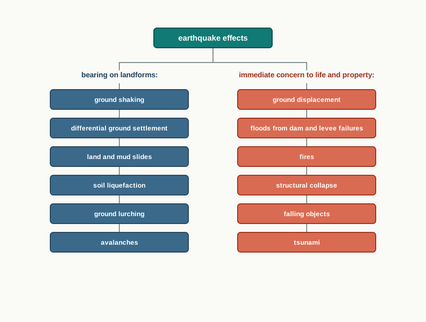
Fig. 3.5 – Immediate effects of an earthquake.
When The Sea Rises: Tsunami
Of all these effects, the tsunami is the one that can reach far beyond the shaking itself. A tsunami will occur only if the epicentre of the tremor lies below oceanic waters and the magnitude of the quake is sufficiently high. It is important to be clear about what a tsunami is: the waves are generated by the tremor, but they are not the earthquake itself. Though the quake activity lasts only a few seconds, its effects can be devastating, provided the magnitude is more than 5 on the Richter scale.
The 2004 Indian Ocean Tsunami
One such disaster struck on 26 December 2004, when a powerful undersea earthquake off Sumatra, in Indonesia, sent tsunami waves across the Indian Ocean. Coasts thousands of kilometres apart were hit — in India, Sri Lanka, Indonesia, Thailand, the Maldives and beyond. The photographs record the destruction; the toll map records the early count of the dead as the news came in on the first night.
Map
Map 3.A1 Caption: The reported death toll around the Indian Ocean on the night of the 2004 tsunami, an early count taken as of 11 PM. Brief: A regional map centred on the Indian Ocean with the earthquake epicentre marked off Sumatra and concentric rings spreading from it across the ocean. Label each affected country with the reported toll exactly as printed: India 2,000 (Andhra Pradesh 200, Pondicherry 100, Tamil Nadu 1,567, Kerala 109); Sri Lanka 4,500; Maldives 15; Malaysia 42; Indonesia 200+; Myanmar 10; with Bangladesh, Thailand and China also labelled. Show the headline figure ‘Asian death toll 10,000 approx as of 11 PM’. India must be shown in its full extent as officially defined. Make clear this is the count on the first night, not the final toll.
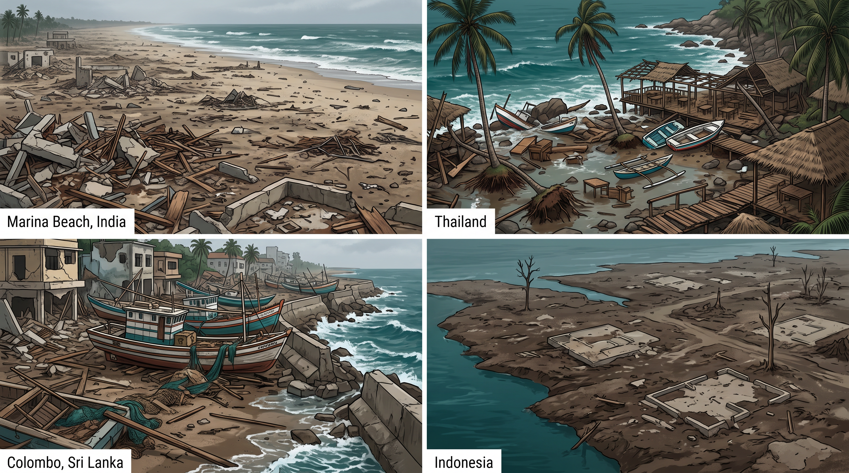
Fig. 3.6 – Coastal destruction left by the 2004 tsunami.
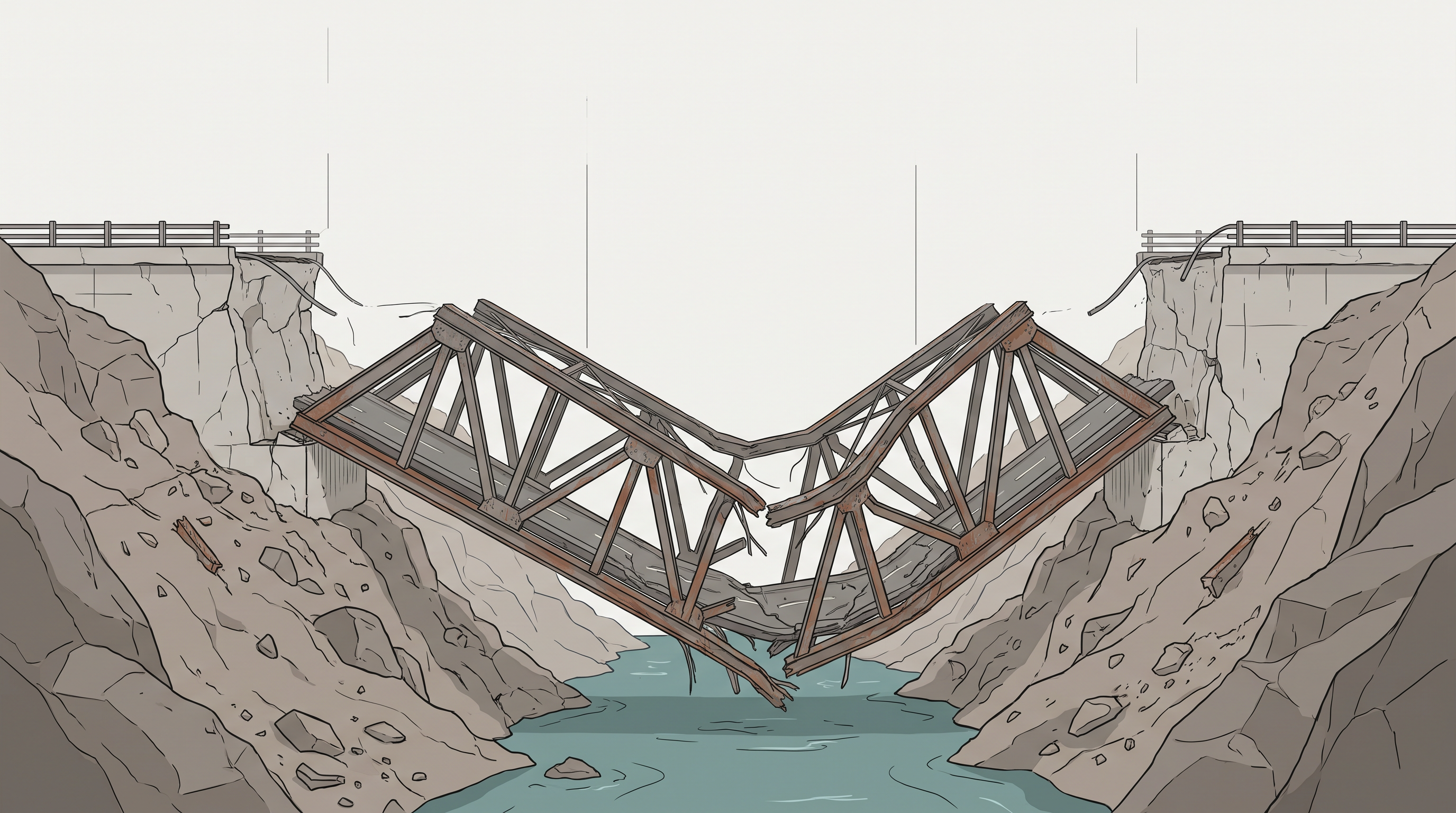
Fig. 3.7 – The Aman Setu bridge damaged by an earthquake.
3.3.1 Frequency Of Earthquake Occurrences
An earthquake is a natural hazard, and a tremor of high magnitude can cause heavy damage to the life and property of people. However, not every part of the globe experiences major shocks — where earthquakes and volcanoes concentrate is the subject of the next chapter.
It also helps to know how often quakes of different sizes happen. The very large ones, of magnitude 8 or more, are quite rare: on average they occur only once in one to two years. The smallest, ‘tiny’ tremors, by contrast, happen almost every minute somewhere on the planet. Most of the shaking the Earth does, then, is far too small to be felt — it is the rare, high-magnitude event that makes a disaster.
3.4 Structure Of The Earth
We now know how the interior was read: not by digging, but by listening to earthquake waves as they raced through the planet, and watching where they sped up, slowed, bent or stopped. What those waves revealed is an Earth built in layers. From the outside in there are three great shells — the crust, the mantle and the core — each with its own thickness, density and state. Fig. 3.8 shows the whole interior in cross-section, from the surface down to the centre at 6,378 km.
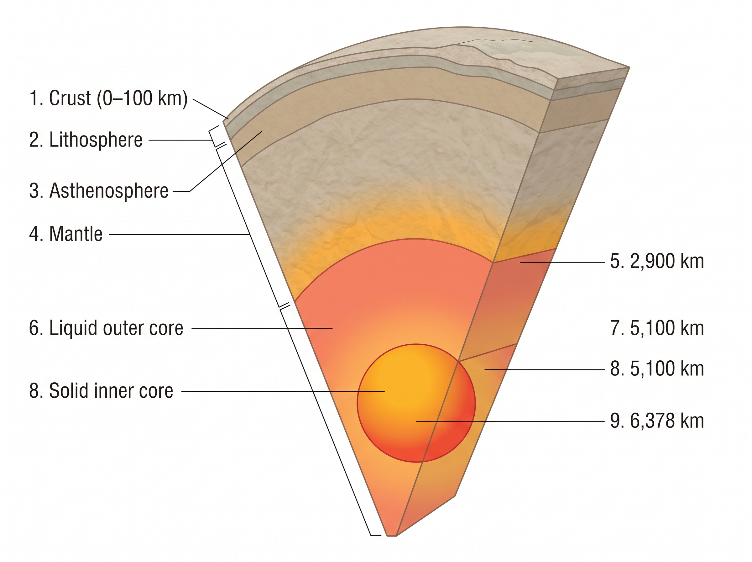
Fig. 3.8 – The interior layers of the Earth.
3.4.1 The Crust
The crust is the outermost solid part of the Earth, and it is brittle — it breaks rather than bends. Its thickness is not the same everywhere, for the crust beneath the oceans is quite different from the crust beneath the continents. Oceanic crust is the thinner of the two, with a mean thickness of about 5 km, while continental crust is around 30 km. Where great mountain systems rise, the continental crust is thicker still: under the Himalayan region, along the northern edge of the Indian subcontinent, it reaches as much as 70 km. The crust is the layer we live on, and the only one we have ever sampled directly.
3.4.2 The Mantle
Below the crust lies the mantle, the portion of the interior that begins at the Moho’s discontinuity — the boundary separating the crust from the mantle — and reaches down to a depth of 2,900 km. The upper part of the mantle is called the asthenosphere. The word astheno means weak, and this zone, thought to extend to about 400 km, is soft enough to flow slowly. It matters a great deal, because it is the main source of the magma that works its way up to the surface during volcanic eruptions.
Two familiar terms come together here. The crust and the uppermost part of the mantle together make up the lithosphere, whose thickness ranges from 10 to 200 km — the solid outer shell within which all earthquakes occur. Below the asthenosphere, the lower mantle continues down towards the core, and it is in a solid state.
3.4.3 The Core
It was the study of earthquake wave velocities that first revealed the core, the innermost region of the Earth. The boundary between the mantle and the core lies at a depth of 2,900 km. The core itself comes in two parts: the outer core is in a liquid state, while the inner core is solid. Both are made of very heavy material, mostly nickel and iron — which is why the core is sometimes called the nife layer, a name built from the chemical symbols for nickel (Ni) and iron (Fe).
The liquid outer core is more than a detail. It is the reason earthquake waves behave as they do in the deep Earth.
3.5 Volcanoes And Volcanic Landforms
You have almost certainly seen pictures of a volcano. A volcano is a place where gases, ashes and molten rock — lava — escape onto the ground. A volcano is said to be an active volcano if these materials are being released now, or have been released in the recent past.
Where does the molten rock come from? The layer below the solid crust is the mantle, which is denser than the crust and holds within it the weaker zone called the asthenosphere. It is from the asthenosphere that molten rock finds its way upward. While it is still inside the Earth, in the upper mantle, this molten rock is called magma. Once it begins moving towards the crust, or reaches the surface, the very same material is called lava. What actually reaches the ground in an eruption is more than lava alone: it includes lava flows, pyroclastic material — the shattered rock, ash and debris blasted out of the vent — volcanic bombs, ash and dust, and gases such as nitrogen compounds, sulphur compounds, and small amounts of chlorine, hydrogen and argon.
3.5.1 Volcanoes
Volcanoes are not all alike. They are classified by two things taken together: the nature of the eruption and the form built at the surface. The major types are set out in Fig. 3.9, and described one by one below.
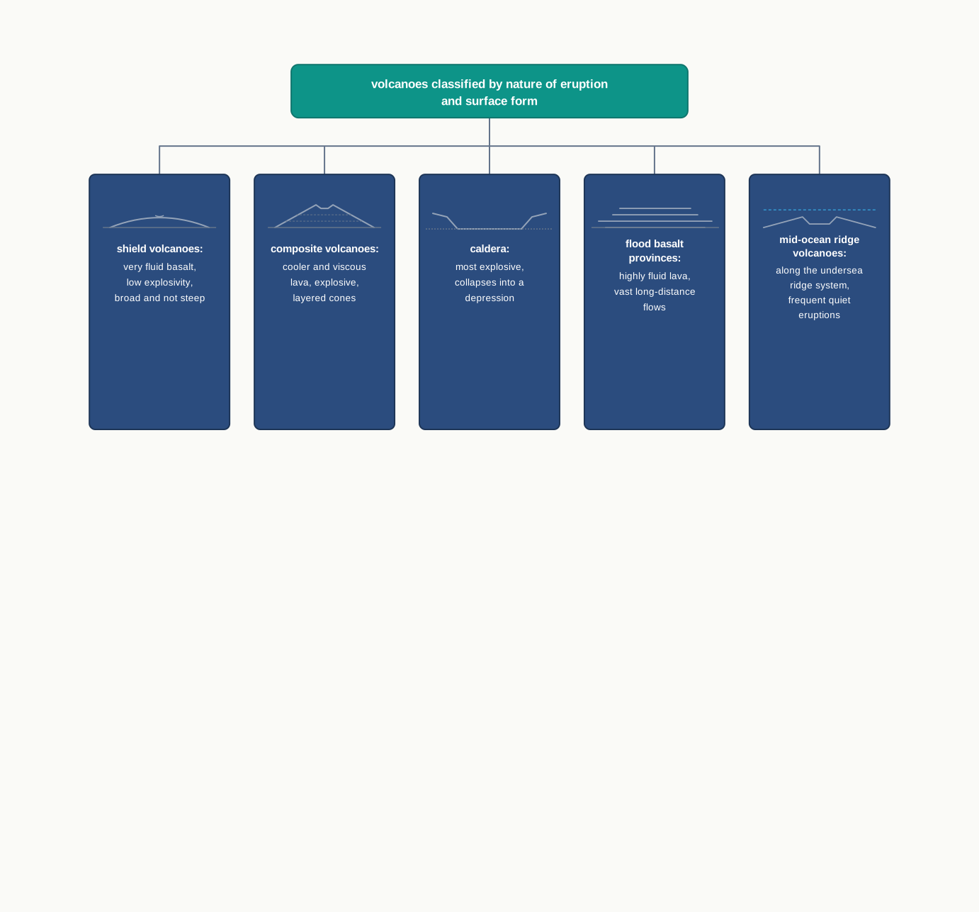
Fig. 3.9 – Classification of volcanoes.
3.5.1.1 Shield Volcanoes
Setting aside the flood basalt flows, shield volcanoes are the largest volcanoes on Earth; the Hawaiian volcanoes, in the Pacific Ocean, are the most famous examples. They are built mostly of basalt, a lava that is very fluid when it erupts. Because the lava is so runny, it spreads far and wide instead of piling up, so these volcanoes are broad and gently sloping rather than steep. Ordinarily they erupt with low explosivity — but they can turn explosive if water somehow gets into the vent, the opening through which the lava rises. At times the rising lava spurts up like a fountain and throws material out around the vent, which builds a smaller, steeper cinder cone.
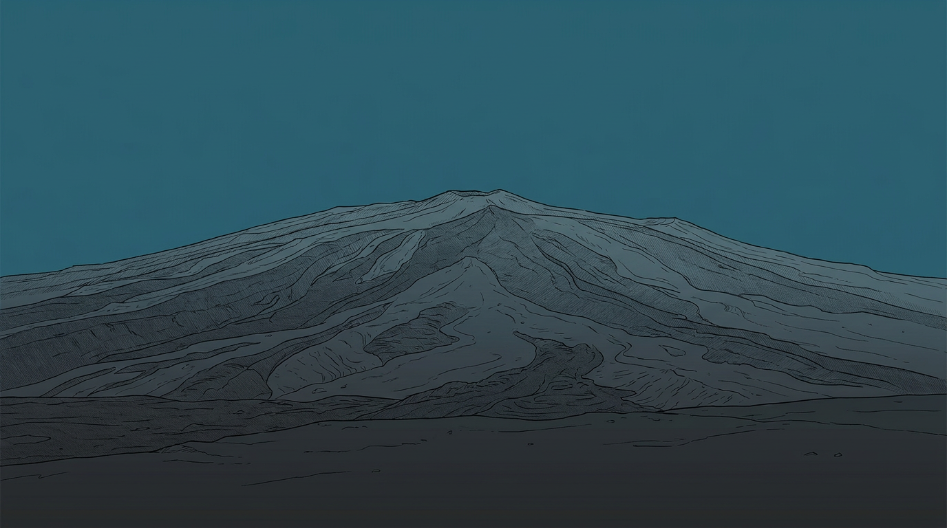
Fig. 3.10 – A broad, gently sloping shield volcano.
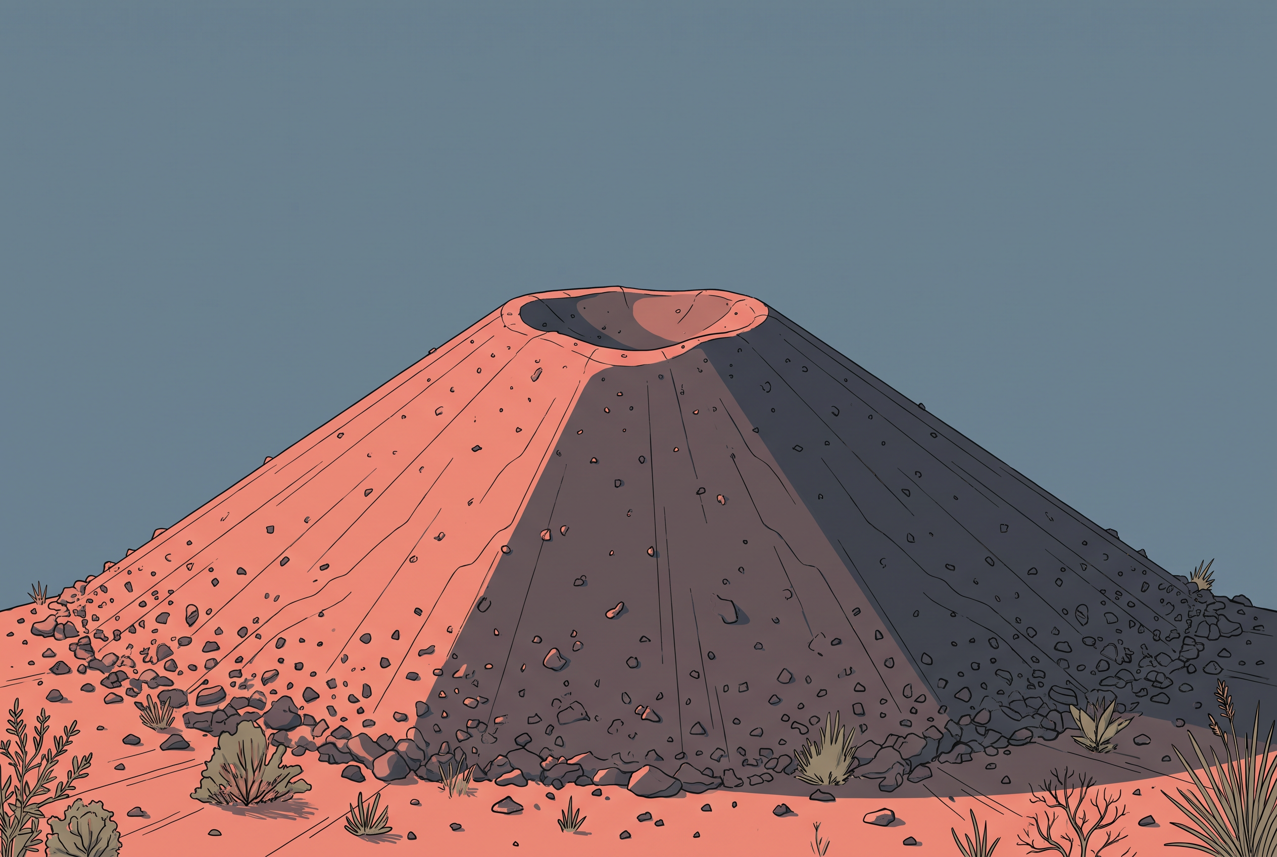
Fig. 3.11 – A steep cinder cone.
3.5.1.2 Composite Volcanoes
Composite volcanoes are built by eruptions of cooler and more viscous lava than basalt — viscous meaning thick and sticky, slow to flow. These eruptions are often explosive, and along with the lava they throw out large quantities of pyroclastic material and ash. This material settles around the vent and builds up in layers, and it is these layers, one upon another, that give the composite volcano its name. The contrast with a shield volcano is worth holding onto: fluid basalt spreads into a broad, gentle shield, while thick, sticky lava erupts violently and stacks into a steeper, layered mountain.
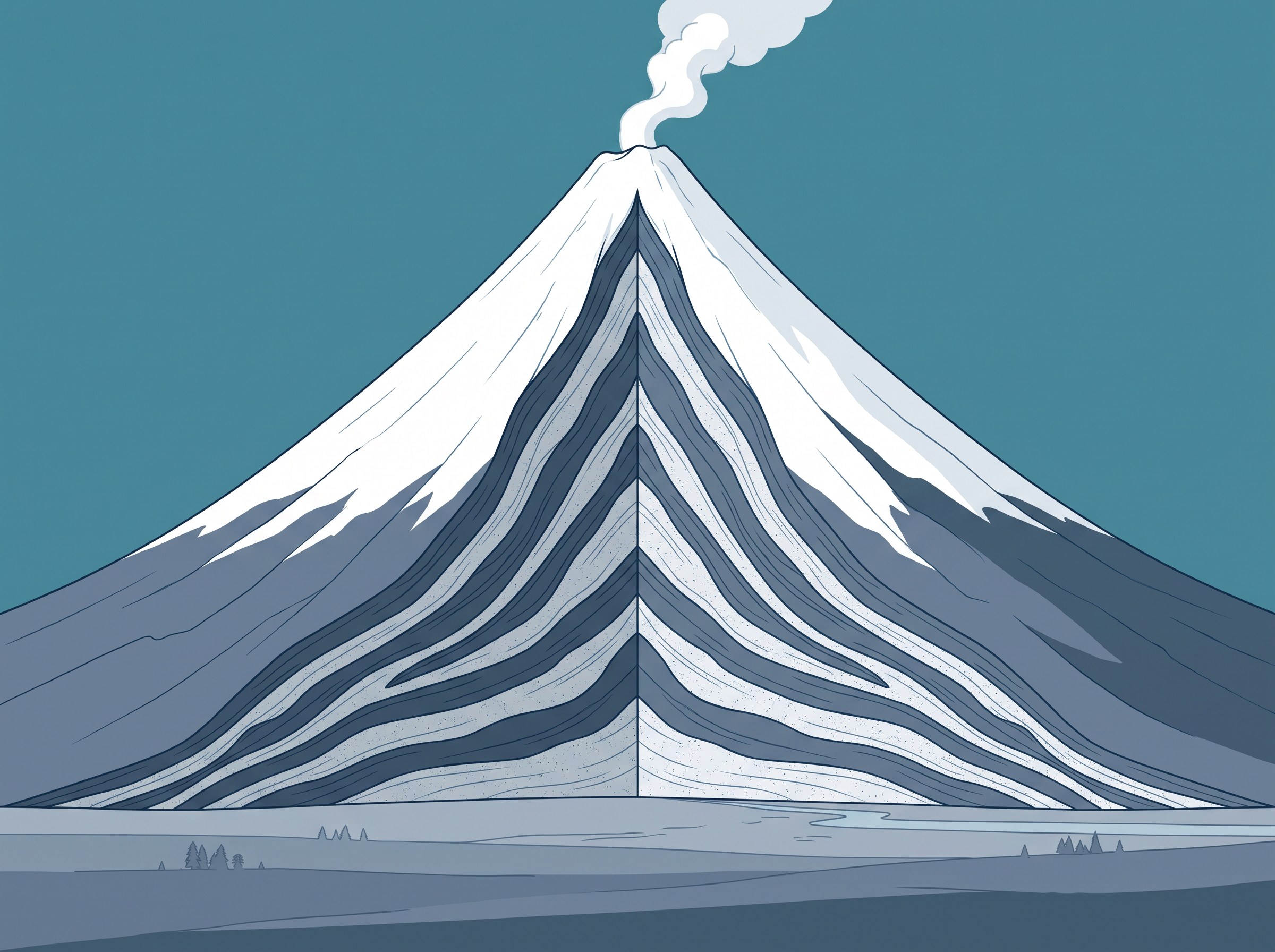
Fig. 3.12 – A layered composite volcano.
3.5.1.3 Caldera
Calderas are the most explosive of all the Earth’s volcanoes. They are so violently explosive that, when they erupt, they tend to collapse into themselves rather than build any tall structure; the collapsed hollow left behind is the caldera. That collapse tells us something about what lies below: the magma chamber feeding the eruption must be not only very large but also close beneath the surface.
3.5.1.4 Flood Basalt Provinces
Flood basalt provinces pour out highly fluid lava that travels great distances. In some parts of the world, thousands of square kilometres lie buried under thick basalt flows. The lava comes in a series of flows, some more than 50 m thick, and individual flows may run for hundreds of kilometres. The Deccan Traps of India — which today cover most of the Maharashtra plateau, in the west of the country — are one such flood basalt province, and a very large one. It is believed that in the beginning the trap formations spread across a much greater area than they do now.
The Deccan Traps show what makes flood basalt volcanism different from the cone-building kind. Nothing here is steep or dramatic in a single eruption; the drama is all in the scale. Quiet, fluid outpourings, repeated over and over, can pave an area the size of a large state — and what survives at the surface today is smaller than what once lay there.
3.5.1.5 Mid-Ocean Ridge Volcanoes
The last type lies hidden beneath the sea. Mid-ocean ridge volcanoes occur in the oceanic areas, along a system of mid-ocean ridges — a chain of undersea mountains — that runs for more than 70,000 km through all the ocean basins. The central part of this ridge erupts frequently, and the workings of the ridge system are taken up in detail in the next chapter.
3.6 Volcanic Landforms
3.6.1 Intrusive Forms
When the lava released in a volcanic eruption cools, it hardens into igneous rocks — rocks formed as molten material solidifies. But cooling does not always happen at the surface. Sometimes the molten rock reaches the open air and cools there; sometimes it cools while still held within the crust. This gives two families of igneous rock: volcanic rocks, which cool at the surface, and plutonic rocks, which cool inside the crust. The lava that cools within the crust cannot spread out freely, so it takes on a variety of shapes, moulded by the space it fills. These shapes are the intrusive forms, and several of them are shown together in Fig. 3.13.
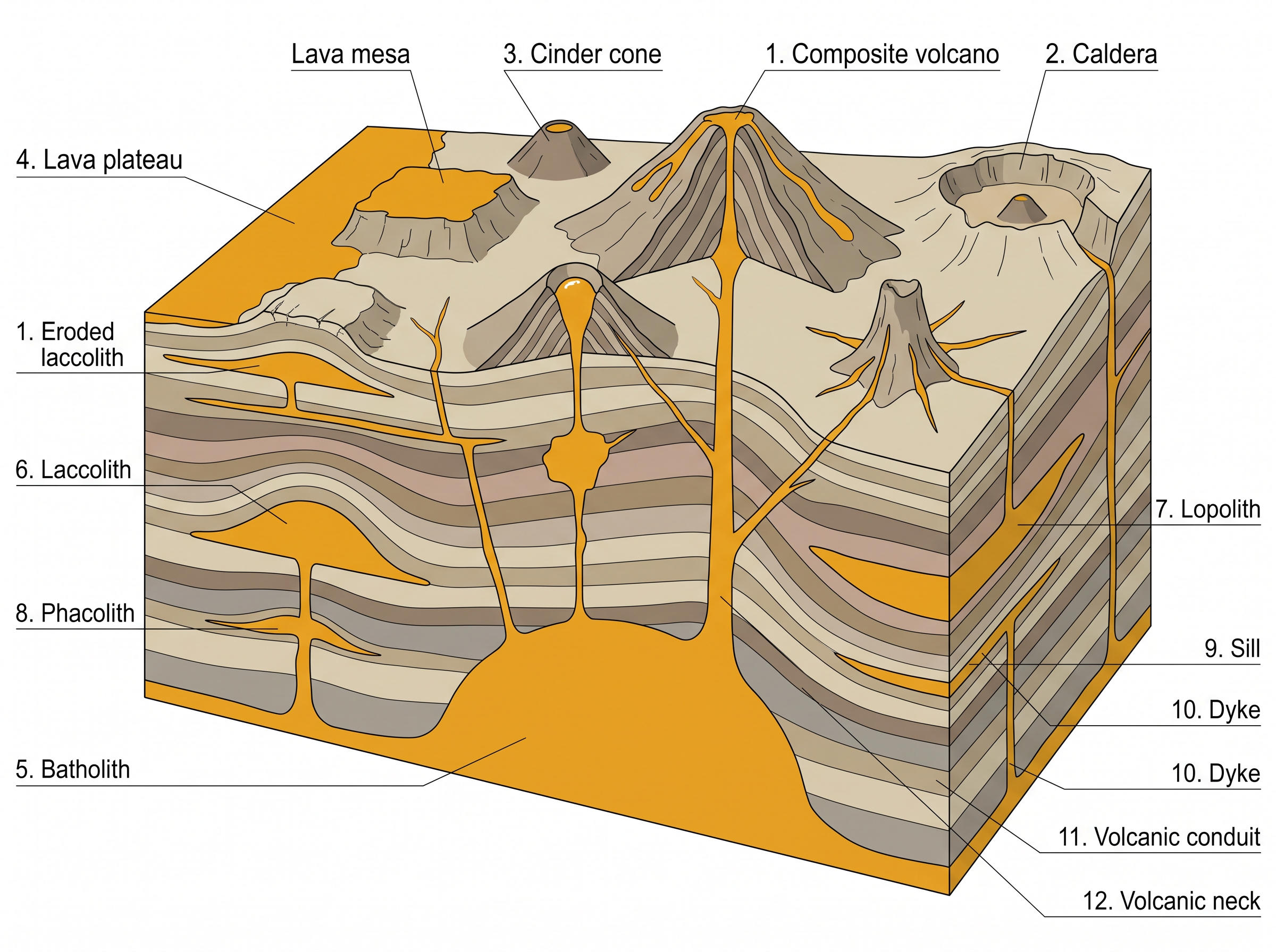
Fig. 3.13 – Volcanic and intrusive igneous landforms.
3.6.1.1 Batholiths
A batholith is a large body of magma that cools deep within the crust and sets into a great dome. Because it forms far below the surface, we come to see it only after denudation — the slow wearing away of the land by weathering and erosion — has stripped off all the rock that once lay above it. Batholiths cover large areas and can reach depths of several kilometres. They are granitic bodies, and in truth they are the cooled remains of the magma chambers that once fed volcanoes.
3.6.1.2 Lacoliths
A lacolith is a large dome-shaped intrusive body with a flat, level base, fed from below by a pipe-like conduit. It is much like the domed shape of a composite volcano at the surface, except that a lacolith sits at depth. It can be thought of as a local store of lava that has pushed up towards the surface. The Karnataka plateau, in southern India, is dotted with domed hills of granite; most of these, now exfoliated — their outer layers peeling away like the skin of an onion — are batholiths or lacoliths laid bare.
3.6.1.3 Lapolith, Phacolith And Sills
As the lava pushes upward, part of it may turn and spread sideways wherever it meets a weak plane in the rock, coming to rest in different shapes. If it settles into a saucer shape, hollow side facing up, it is called a lapolith. Where a wavy mass of intrusive rock gathers at the trough of a syncline — a downfold in the rock — or at the crest of an anticline — an upfold — with a definite conduit leading down to a magma chamber below, one that later developed into a batholith, it is called a phacolith. And where the intrusive rock forms a near-horizontal sheet, it is called a sill or a sheet, the two names divided only by thickness: the thin ones are sheets, the thick horizontal masses are sills.
3.6.1.4 Dykes
When lava forces its way up through cracks and fissures in the ground and solidifies there, it cools almost perpendicular to the surface, setting into a wall-like body. Such a structure is a dyke. Dykes are the most common intrusive form in the western Maharashtra area, where they are regarded as the feeders that once supplied the eruptions building the Deccan traps.
The intrusive forms are easier to hold in mind when sorted by their shape and the way they sit in the crust, as Fig. 3.14 sets out.
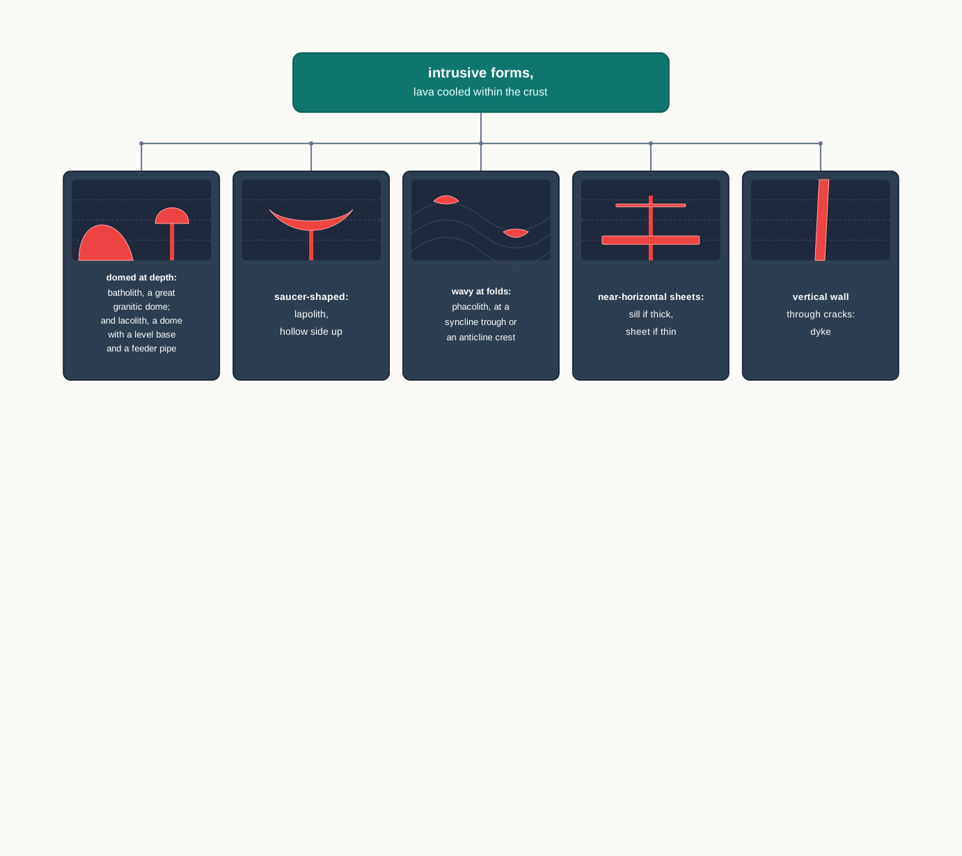
Fig. 3.14 – Classification of intrusive volcanic forms.
3.7 Summary
- No one can reach the Earth’s interior — its radius is about 6,378 km — so almost everything we know about it comes from indirect evidence rather than from samples.
- The direct sources are limited: surface and mine rock, deep boreholes, and the material thrown out by volcanic eruptions.
- The indirect sources are richer: temperature, pressure and density all rise with depth; meteors offer a comparison; gravity (and its anomalies) and magnetism map the crust; and, most powerful of all, seismic activity reveals the whole layered interior.
- An earthquake is a sudden release of energy along a fault. The energy is released at the focus below the surface; the point directly above it is the epicentre, the first place to feel the waves.
- Earthquake waves come as body waves and surface waves. P-waves are fastest and travel through solids, liquids and gases; S-waves are slower and travel only through solids; surface waves arrive last and are the most destructive.
- Waves change speed and bend as they cross materials of different density. Because S-waves cannot cross the liquid outer core, a shadow zone forms — the S-wave shadow zone covers a little over 40 per cent of the Earth’s surface.
- Earthquakes are grouped by cause — tectonic, volcanic, collapse, explosion and reservoir induced — and measured by magnitude on the Richter scale (0–10) or by intensity on the Mercalli scale (1–12).
- An earthquake has many hazardous effects. The first six bear on landforms; the rest threaten life and property. A tsunami results only when the epicentre lies below the ocean and the magnitude is high.
- The Earth is layered into crust, mantle and core. The crust is thin and brittle; the mantle reaches to 2,900 km and holds the weak asthenosphere; the core, from 2,900 km to the centre, has a liquid outer part and a solid inner part of nickel and iron.
- A volcano is where lava, gases and ash escape to the surface. Volcanoes are classified — as shield, composite, caldera, flood basalt provinces and mid-ocean ridge — by how they erupt and the form they build.
- Lava that cools within the crust forms the intrusive landforms: batholiths, lacoliths, lapoliths, phacoliths, sills and dykes.
Read from the outside in, the whole chapter comes together in Fig. 3.15.
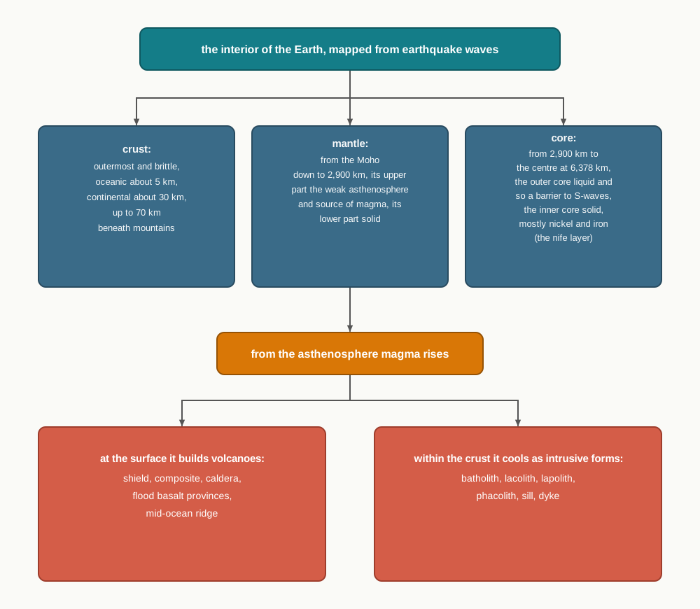
Fig. 3.15 – The interior of the Earth and volcanism.
What This Chapter Cannot Tell You
The interior is read from waves and inference, not from samples: below about 12 km no one has ever held a piece of it, so its exact make-up and its temperature at each depth remain estimates rather than measurements. The seismic method reveals where each layer begins and whether it is solid or liquid, but not the full chemistry within it. And though the chapter explains why the Earth shakes and why it erupts, it does not tell us when or where the next quake or eruption will strike, or why they cluster where they do — that distribution is the work of the next chapter.
3.8 NCERT Questions
Which one of the following earthquake waves is more destructive?
- P-waves
- S-waves
- Surface waves
- None of the above
Which one of the following is a direct source of information about the interior of the earth?
- Earthquake waves
- Volcanoes
- Gravitational force
- Earth magnetism
Which type of volcanic eruptions have caused Deccan Trap formations?
- Shield
- Flood
- Composite
- Caldera
Which one of the following describes the lithosphere:
- upper and lower mantle
- crust and upper mantle
- crust and core
- mantle and core
What are body waves? (30 words)
Name the direct sources of information about the interior of the earth. (30 words)
Why do earthquake waves develop shadow zone? (30 words)
Briefly explain the indirect sources of information of the interior of the earth other than those of seismic activity. (30 words)
What are the effects of propagation of earthquake waves on the rock mass through which they travel? (150 words)
What do you understand by intrusive forms? Briefly describe various intrusive forms. (150 words)
3.9 Check Your Concepts
The chapter gives the very same molten rock two different names. Name both, and state what decides which name applies.
Oceanic and continental crust are not the same thickness. Give the mean thickness of each, and state how thick the continental crust becomes beneath the Himalayan region.
Read Fig. 3.8. State the depth of the boundary between the mantle and the core, and describe the physical state of the outer core and of the inner core.
Read Fig. 3.4. Between which two angular distances from the epicentre does the shadow zone of both P- and S-waves lie, and beyond which angle do S-waves fail to arrive altogether?
A shield volcano is broad and gently sloping, while a composite volcano is a steep, layered cone. Explain how the nature of the lava in each case leads to its shape and to its explosivity.
The same earthquake can be measured on both the Richter scale and the Mercalli scale. State what each scale measures, and explain why two different places may record very different intensities for one and the same earthquake.
No one has ever reached deeper than about 12 km, yet the chapter can describe the state of the outer core more than 2,900 km down. Explain how earthquake waves make such a claim possible, and state one thing this evidence still cannot tell us about the deep interior.