Chapter 9: Atmospheric Circulation And Weather Systems
The barometer in the fishing harbour on the Bay of Bengal — the arm of the Indian Ocean that curves between eastern India and the coasts to its east — had been sinking for two days. Nobody could see why. The sky was still bright, the sea still warm, warmer than a swimming pool. But the falling needle was the sea speaking. Somewhere out over that warm water, the air had grown hot, thinned, and lifted, leaving less weight pressing down. Air is heavy, and where it grows light, heavier air comes rushing in to take its place. That rushing air is wind.
By the second night the wind had a shape. It was not blowing in from one direction; it was turning, curling inward on itself in a vast anticlockwise spiral hundreds of kilometres wide. At its heart the rushing air was climbing, wringing itself out as rain, feeding on the sea’s warmth and turning faster.
Then, near dawn, the wind stopped. The clouds parted. For twenty strange minutes there was blue sky and dead calm overhead — the eye of the storm, passing directly over the harbour. The fishermen knew not to trust it. Behind the calm came the second wall of wind, harder than the first.
A storm like this is not chaos. It is air obeying a few plain rules, at a scale that can level a coastline.
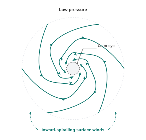
Fig. 9.0 – Surface winds of a northern-hemisphere low-pressure system.
This chapter will let you answer each of these — not by memory, but by following the air.
9.1 Atmospheric Pressure
Earlier in this book you saw how the Sun heats the Earth’s surface unevenly. That unevenness is where wind begins. Air expands when it is heated and is compressed when it cools. Warm air spreads out, grows lighter and presses down less; cool air packs together, grows heavier and presses down more. Heating alone, then, produces differences in pressure from one place to another.
These pressure differences set air in motion. Air flows from where pressure is high to where it is low, and air moving horizontally across the surface is wind. Pressure also decides whether air rises or sinks. As it travels, wind carries heat and moisture around the planet, so that no single region keeps all the warmth the Sun gives it, and the Earth as a whole holds a steady temperature.
When moist air rises it cools, and cooling wrings out its water as cloud and rain. This one chain — uneven heating, a difference in pressure, moving air, rising and cooling — runs through the whole chapter: the forces that steer the wind, the belts of pressure that circle the globe, the meeting of air masses, and the violent storms that close it.
The Weight Of Air
Your body is pressed on every side by air, though you rarely notice it. Climb high and the air thins — there is less of it stacked above you pressing down — and a climber begins to feel breathless. Atmospheric pressure is the weight of a column of air standing over a unit of area, measured from mean sea level right up to the top of the atmosphere.
Pressure is measured in the millibar, the unit meteorologists use for the weight of air; the average pressure at sea level is 1,013.2 millibar. Because gravity pulls air downward, the air near the surface is packed densest and presses hardest, so pressure is greatest at sea level and falls as you rise. It is read from a barometer — either a mercury barometer or an aneroid barometer, the instruments you meet in detail in the practical work of this course.
At any height, pressure also varies from place to place, and that horizontal variation is the primary cause of wind. It is the difference in pressure, not its absolute value, that pushes air from one place toward another.
9.1.1 Vertical Variation of Pressure
In the lower atmosphere, pressure falls quickly as height increases. The fall is roughly 1 millibar for every 10 metres you climb. But it does not drop at the same rate all the way up.
Table 9.1 sets out the pressure and temperature at chosen heights for a standard atmosphere — an agreed, average model of the air used only for comparison. Both quantities fall with height, and the pressure drop is steepest low down, near the ground.
The force pushing air upward — the vertical pressure gradient — is in fact much stronger than the horizontal one that drives wind. Yet we feel no fierce upward gusts. Gravity pulls down with a nearly equal and opposite force, and the two almost cancel, leaving the air free to move mostly sideways rather than up.
9.1.2 Horizontal Distribution of Pressure
Small differences in pressure across the surface matter greatly, because they set both the direction and the speed of the wind. To study how pressure is spread out horizontally, geographers draw isobars — lines joining places that have equal pressure — all read at one level.
Altitude on its own lowers pressure, and that large effect would drown out the smaller, weather-driven differences we actually care about. So a station’s reading is first corrected, or reduced, to the value it would have at sea level, which strips out the effect of the station’s own height. These sea-level figures are what appear on a weather map.
Fig. 9.1 shows how isobars arrange themselves around pressure systems. A low-pressure system is ringed by one or more isobars closing in on the lowest pressure at the centre; a high-pressure system is ringed around the highest pressure at the centre.
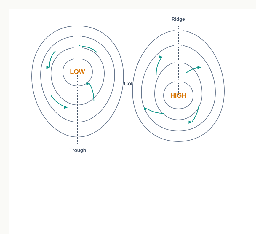
Fig. 9.1 – Isobars, pressure and wind systems in the northern hemisphere.
9.1.3 World Distribution of Sea Level Pressure
Averaged over the whole globe, pressure does not scatter at random. It settles into broad belts that run roughly parallel to the equator. Fig. 9.2 and Fig. 9.3 map this distribution for January and for July.
Near the equator the air is strongly heated, rises, and leaves low pressure behind — the equatorial low. Around 30° N and 30° S lie belts of high pressure, the subtropical highs. Further poleward, near 60° N and 60° S, pressure falls again in the sub polar lows. Over the cold poles themselves the air is dense and heavy, giving the polar high.
These belts are not fixed in place. They oscillate with the apparent movement of the Sun — the seasonal shift, north and south, of the latitude at which the Sun stands overhead. In the northern hemisphere the belts slide southward in winter and northward in summer, carrying their weather with them.
Map
Fig. 9.2 Caption: The world distribution of sea-level pressure in January, in millibars. Brief: World map showing sea-level isobars labelled in millibars for January. Mark the pressure belts and cells — the equatorial low along the ITCZ, the subtropical high cells (H) over the oceans, the sub polar lows and the polar highs — with H and L symbols as printed, and short surface-wind arrows. Include a distance scale. Show India’s full extent as officially defined. The pattern shown is for January.
Map
Fig. 9.3 Caption: The world distribution of sea-level pressure in July, in millibars. Brief: World map showing sea-level isobars labelled in millibars for July. Mark the same belts and cells shifted for the July position — the ITCZ drawn north of its January line, the subtropical high cells (H), the low (L) over the heated continental interior, and short surface-wind arrows. Include a distance scale. Show India’s full extent as officially defined. The pattern shown is for July.
9.2 Forces Affecting the Velocity and Direction of Wind
You already know that pressure differences set the air in motion, and that air in motion is wind, blowing always from high pressure toward low. But the wind you actually feel is never a simple straight rush from high to low. Near the ground it is shaped by three forces acting together.
The first is the push of the pressure difference itself. The second is friction, the drag of the surface on the moving air. The third is the Coriolis force, which arises because the Earth is spinning beneath the wind. On top of these, gravity pulls the air downward. The real wind — its speed and its direction — is the net outcome of them all.
9.2.1 Pressure Gradient Force
The difference in pressure from place to place is itself a force. The pressure gradient is the rate at which pressure changes with distance — how sharply it drops as you move from a high toward a low.
\[\text{Pressure gradient} = \frac{\text{change in pressure (mb)}}{\text{distance over which it changes (km)}}\]
On a weather map you read this straight off the isobars. Where isobars crowd close together, pressure changes quickly over a short distance, the gradient is steep, and the wind is strong. Where isobars lie far apart, the gradient is gentle and the wind is light. The pressure gradient force points from high pressure to low, at right angles to the isobars.
9.2.2 Frictional Force
Friction is the drag the ground exerts on the air sliding over it, and it works on the wind’s speed, slowing it down. Its grip is strongest right at the surface and weakens with height, reaching up to about 1 to 3 km before it fades to nothing. Over the sea, whose surface is far smoother than the land, friction is least.
9.2.3 Coriolis Force
The Earth’s rotation about its axis bends the path of the wind. This bending is described by the Coriolis force, named after the French physicist who first described it in 1844. It turns the wind to the right of its path in the northern hemisphere and to the left of its path in the southern hemisphere.
The deflection grows with the wind’s speed — a faster wind is turned more. It also depends on latitude: the Coriolis force is strongest at the poles and weakens toward the equator, where it falls to zero. So the same wind is bent hard in high latitudes and barely at all near the equator.
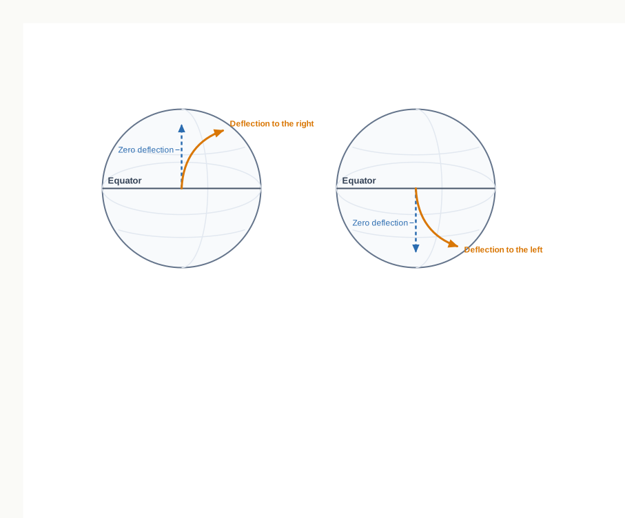
Fig. 9.4 – The Coriolis effect on moving air.
The Coriolis force acts at right angles to the pressure gradient force, which itself acts at right angles to the isobars. These two forces, pulling perpendicular to each other, are why the wind does not run straight into a low but instead blows around it. The stronger the pressure gradient force, the faster the wind, and the larger the deflection.
Why No Cyclone Forms At The Equator
At the equator the Coriolis force is zero. With nothing to bend it, the wind blows straight down the pressure gradient, perpendicular to the isobars, right into the centre of a low. The low is simply filled in rather than deepened. Because the inflowing air cannot be set spinning, a tropical cyclone cannot organise there — which is why these storms never form on the equator itself.
9.2.4 Pressure and Wind
The velocity and direction of the wind are the net result of these forces, and the balance between them changes with height. In the upper atmosphere, 2 to 3 km above the surface, the wind is free of friction and is governed by just two forces: the pressure gradient and the Coriolis force.
When the isobars are straight and friction is absent, these two forces come into exact balance — equal in strength and opposite in effect. The wind then blows neither across the isobars nor into the low, but parallel to the isobars. This balanced upper wind is the geostrophic wind.
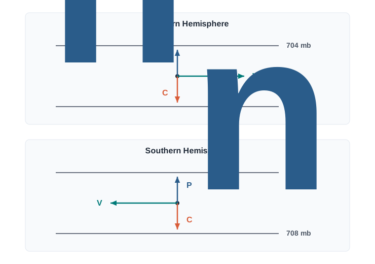
Fig. 9.5 – The geostrophic wind balance.
Winds Around Highs And Lows
The circling of wind around a low is called cyclonic circulation; around a high it is called anti cyclonic circulation. Which way it circles depends on the hemisphere, because the Coriolis force turns the wind opposite ways north and south of the equator. Table 9.2 sets out the four cases.
Surface winds and the winds high above are closely linked. Over a low, air converges at the surface and rises; over a high, air sinks from above and diverges, spreading out at the surface. Rising air is what the weather needs: as it climbs it cools, its moisture condenses, and cloud and rain follow. Convergence over a low is one cause of this rising; eddies, convection currents, air forced up over hills, and air lifted along fronts are others.
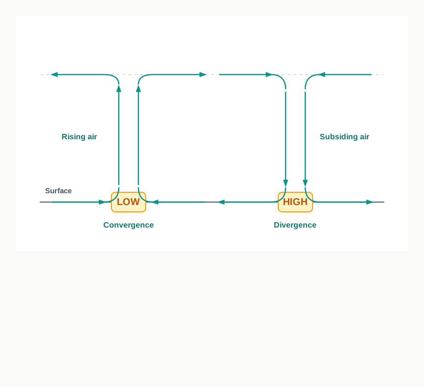
Fig. 9.6 – Surface and upper-level airflow over pressure systems.
9.3 General Circulation of the Atmosphere
Winds do not blow at random across the globe. Averaged over the whole planet and over the year, they settle into a steady, large-scale pattern — the general circulation of the atmosphere, the pattern of movement of the planetary winds.
This pattern depends on five things working together: the way solar heating varies with latitude; the pressure belts that this heating raises; the seasonal migration of those belts as the Sun’s overhead point shifts north and south; the uneven distribution of continents and oceans; and the rotation of the Earth. Fig. 9.7 gives a simplified picture of the whole system.
The circulation of the air does more than move weather. Its large-scale winds also drag the surface waters of the oceans into slow currents, and those currents in turn help shape the Earth’s climate. Air and ocean work as one coupled machine.
The Three Cells
Follow the air from the equator. Near the equator lies the Inter Tropical Convergence Zone (ITCZ), the belt where the surface winds of the two hemispheres meet. Here strong insolation — the incoming solar radiation that heats the ground — warms the air, which rises by convection and leaves low pressure at the surface. Winds from the tropics blow in toward this low and converge.
The rising air climbs to the top of the troposphere, the lowest layer of the atmosphere where weather happens, at an altitude of about 14 km, and then spreads poleward. Around 30° N and 30° S it piles up and cools, and much of it sinks back to the ground, building a subtropical high. Near the surface this sinking air flows back toward the equator as the easterlies, or trade winds, closing the loop. Such a closed loop of rising and sinking air is called a cell, and this tropical one is the Hadley cell.
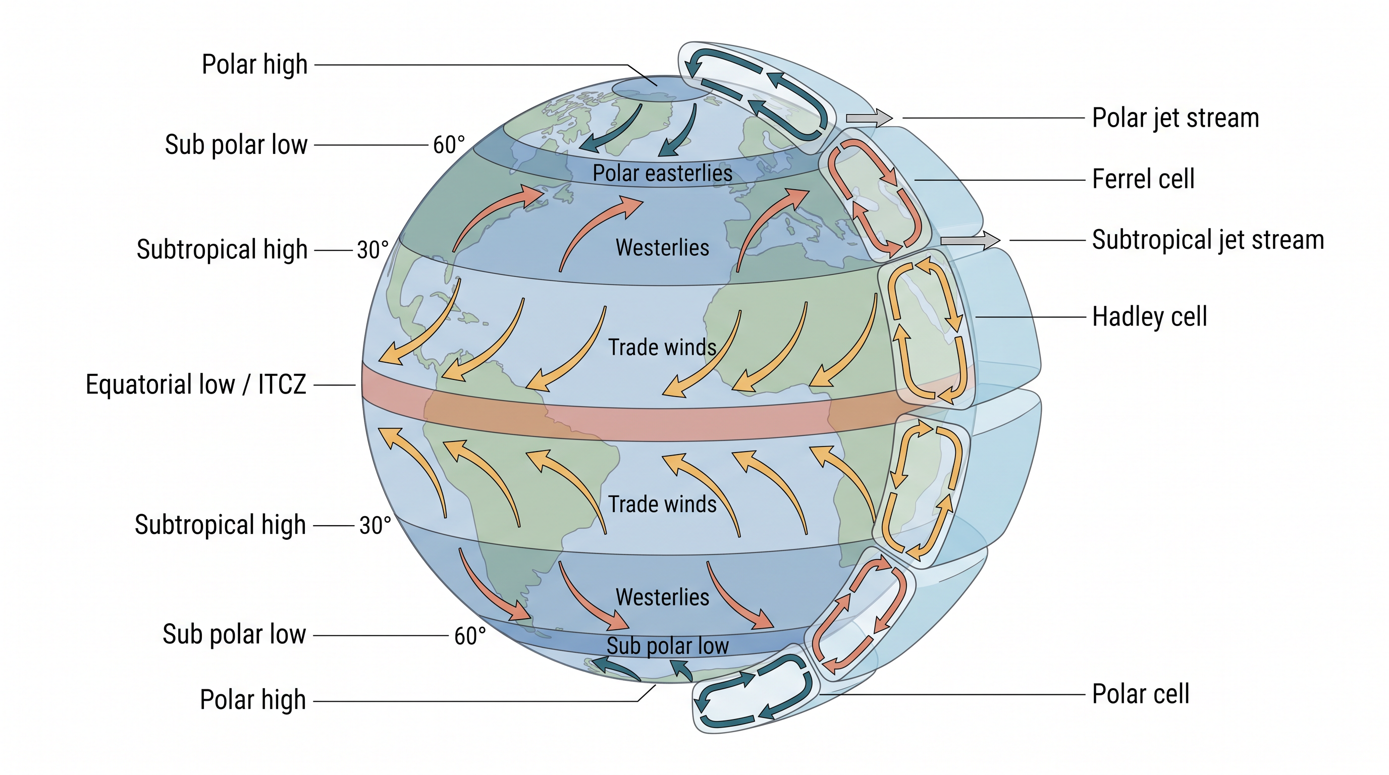
Fig. 9.7 – General circulation of the atmosphere.
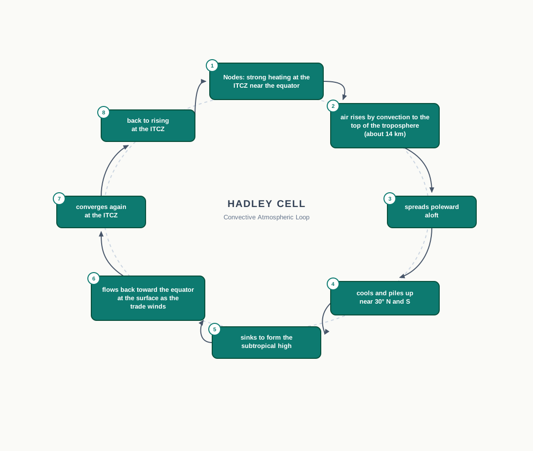
Fig. 9.8 – The Hadley cell circulation loop.
Two more cells complete the pattern. In the middle latitudes, warm air moving poleward from the subtropical high meets cold air sinking from the poles; the surface winds here blow from the west and are called the westerlies, and the loop is the Ferrel cell. At the poles, cold dense air sinks and flows out toward the middle latitudes as the polar easterlies, forming the polar cell. These three cells, turning in each hemisphere, set the whole general circulation, and together they carry heat from the hot low latitudes toward the cold high latitudes — the transfer that keeps the circulation running.
The Winds And The Ocean
The general circulation also reaches down into the sea. The large-scale winds start the great, slow-moving ocean currents; the oceans, in return, feed energy and water vapour back into the air. These exchanges are gradual, spread over vast stretches of ocean, yet they steer weather far away.
9.3.1 Seasonal Wind
Because the pressure and wind belts migrate with the seasons, following the region of strongest heating, the winds over some parts of the world reverse from one season to the next. This seasonal reversal is the monsoon, felt most strongly over southeast Asia — the winds blow one way in summer and the opposite way in winter. You will study the Indian monsoon in detail in the companion book on India’s physical environment; here it is enough to see it as the general circulation bending to the seasons.
9.3.2 Local Winds
The general circulation is the planet-wide backdrop. On top of it, the different ways in which land, water and slopes heat and cool through the day and through the year raise their own smaller winds — common local or regional winds that blow only over a limited area. Two familiar kinds follow.
9.3.3 Land and Sea Breezes
Land and sea absorb and release heat at different speeds, and that one difference drives a daily wind at the coast. By day the land heats faster and grows warmer than the sea. The air over the warm land rises, leaving low pressure there, while the cooler sea holds higher pressure. Air then flows from sea to land — the sea breeze.
At night the flow reverses. The land loses its heat faster and becomes cooler than the sea, so now the higher pressure sits over the land and the lower pressure over the water. The wind blows from land to sea — the land breeze. Fig. 9.9 shows both.
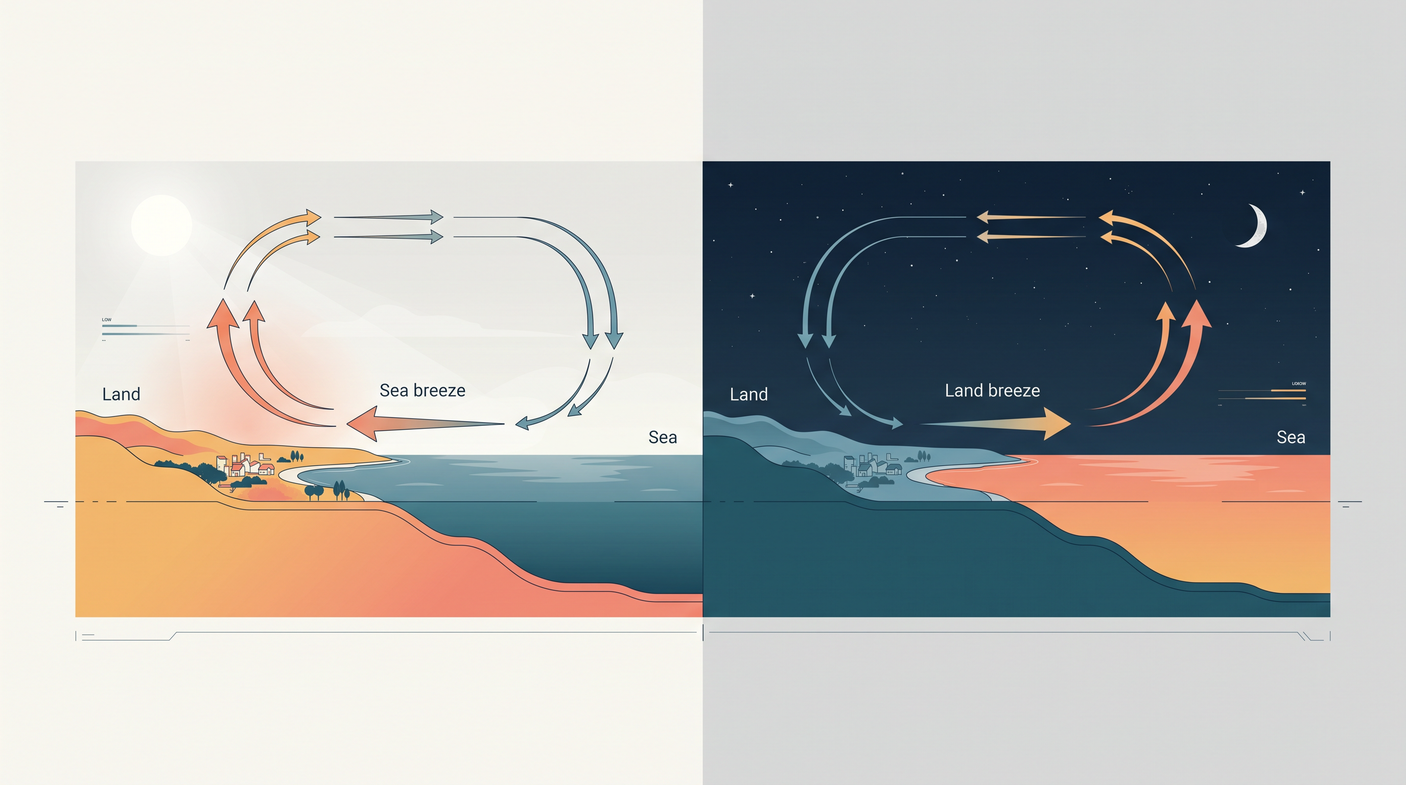
Fig. 9.9 – Coastal land and sea breezes.
9.3.4 Mountain and Valley Winds
Slopes, like coasts, heat and cool unevenly, and they too raise a daily wind. By day the mountain slopes warm up, the air against them rises, and air flows up out of the valley to fill the gap — the valley breeze. By night the slopes cool, the air on them grows dense and heavy, and it drains downhill into the valley as the mountain wind. When this cold, dense air pours down from high plateaus and ice fields, it is called a katabatic wind.
A different, warm wind blows on the far, sheltered side of a range. As moist air is forced up and over the mountains, its moisture condenses and falls as rain on the windward side. The air that then descends the leeward slope is dry, and it is warmed as it sinks by the adiabatic process — the heating a gas undergoes purely from being compressed, with no heat added from outside. This dry, warm wind can melt lying snow in a short time.
9.4 Air Masses
When a body of air rests over a wide, uniform surface for long enough, it slowly takes on the qualities of that surface. Sit over a warm tropical ocean and the air grows warm and moist; sit over a cold, dry continent and it grows cold and dry. Air that has in this way acquired distinctive, even properties of temperature and humidity is an air mass — a large body of air with little horizontal variation in temperature and moisture from one part of it to another.
The uniform surface that gives an air mass its character is its source region. For a source region to work, it must be extensive and much the same throughout — a vast ocean or a vast plain — so that the air lying over it is heated and moistened evenly, with no sharp differences from place to place.
Naming The Air Masses
Air masses are classified by where they form. There are five major kinds of source region: warm tropical and subtropical oceans; the subtropical hot deserts; the relatively cold high-latitude oceans; the very cold, snow-covered continents of high latitudes; and the permanently ice-covered continents of the Arctic in the far north and Antarctica in the far south.
Each source region produces its own type of air mass, and the names are built from two clues. The first letter, in lower case, marks the surface: maritime (m) for air formed over ocean, continental (c) for air formed over land. The second, a capital, marks the latitude: tropical (T) for warm low-latitude sources, polar (P) for cold high-latitude sources, and arctic (A) for the coldest, ice-covered sources. Five types are recognised in all: maritime tropical (mT), continental tropical (cT), maritime polar (mP), continental polar (cP) and continental arctic (cA). As a rule, tropical air masses are warm and polar air masses are cold.
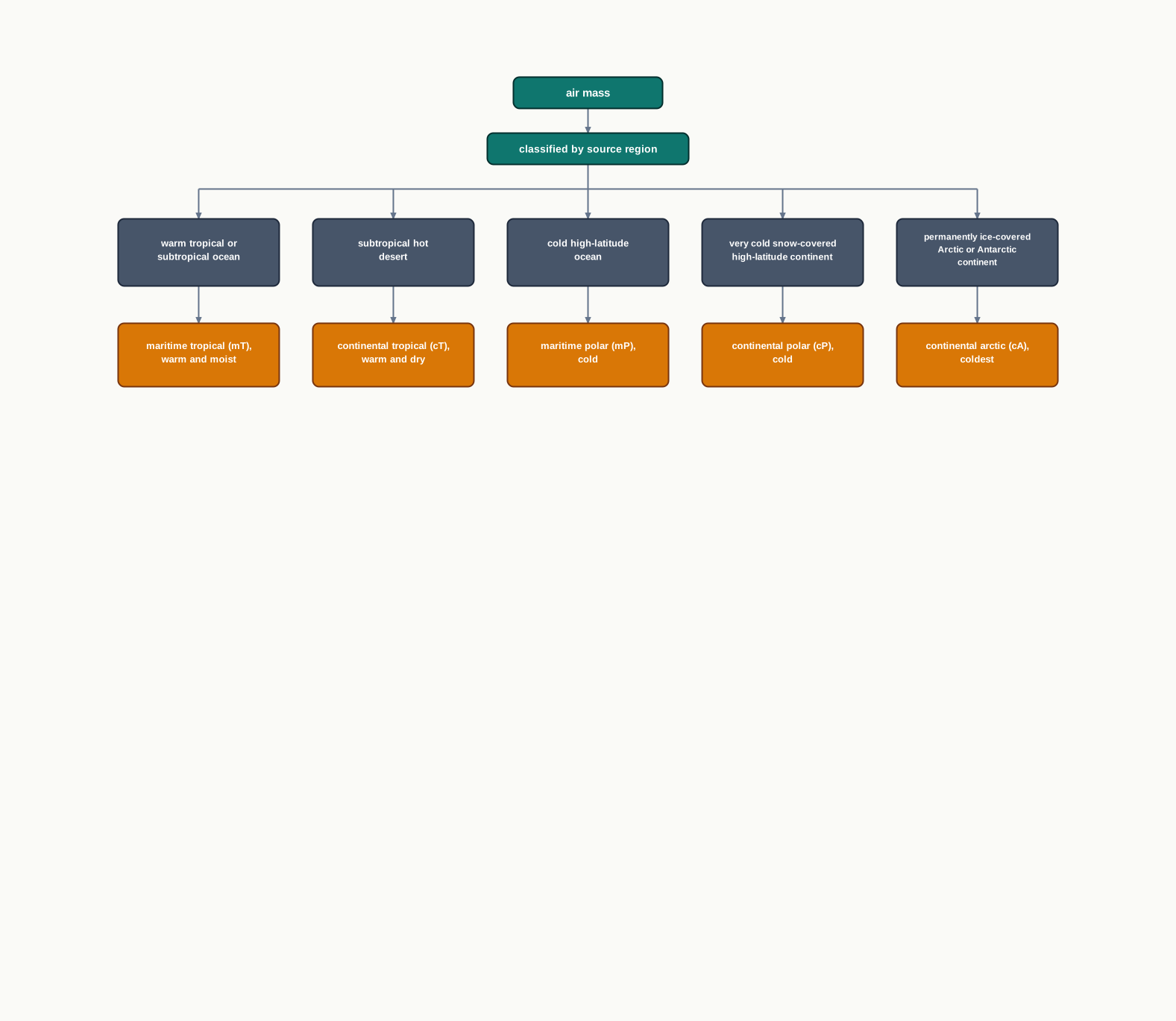
Fig. 9.10 – Classification of air masses by source region.
9.5 Fronts
The air masses of the last section rarely stay put. When two of them — one warm, one cold — drift together, they do not simply blend. Their differences in temperature and density are too great, so they meet along a sharp boundary zone. This boundary is a front, and the process by which it forms is called frontogenesis.
Fronts form and live in the middle latitudes — the temperate belts between the tropics and the poles — where warm tropical air and cold polar air are drawn up against each other. A front is marked by a steep gradient in temperature and pressure: cross it, and both change abruptly over a short distance. Because the lighter warm air is forced to rise along the boundary, a front makes the air lift, cool, and build cloud and precipitation.
The Four Fronts
Fronts are grouped into four types by which air mass is doing the moving. When the boundary holds its place and neither air mass advances, it is a stationary front. When the cold air pushes forward against the warm air mass, the contact zone is a cold front. When instead the warm air mass advances against the cold, the contact zone is a warm front. And when a cold front catches up with a warm front and lifts the warm air entirely off the ground, the result is an occluded front.
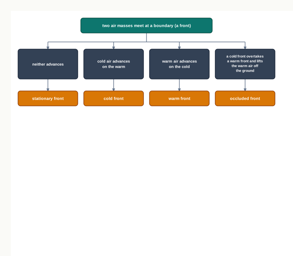
Fig. 9.11 – The four types of weather fronts.
The cold front and the warm front behave quite differently, and Fig. 9.12 shows why. Along a warm front the warm air slides up over the cold air on a gentle slope. Along a cold front the dense cold air wedges under the warm air and shoves it up far more steeply. The occluded front, drawn third, is the stage where the warm air has been squeezed off the surface altogether.
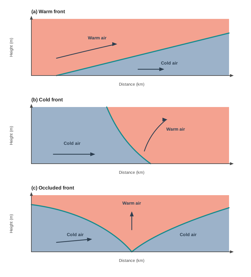
Fig. 9.12 – Vertical sections of warm, cold and occluded fronts.
9.6 Extra Tropical Cyclones
The low-pressure storm systems that develop in the middle and high latitudes, beyond the tropics, are the extra tropical cyclones, also called middle-latitude cyclones. They are built around fronts, and the passage of a front is what brings the abrupt shifts in weather these regions are known for.
How One Forms And Dies
An extra tropical cyclone forms along the polar front — the front where cold polar air meets the warmer air of the middle latitudes. At first this front is stationary. In the northern hemisphere, warm air lies to its south and cold air to its north. When pressure drops along the front, the warm air pushes northward and the cold air pushes southward, and this sets an anticlockwise cyclonic circulation turning.
That circulation grows into a well-developed cyclone with two fronts — a warm front leading and a cold front following. Between them sits a warm sector, a wedge of warm air caught between the cold air ahead and the cold air behind. Along the warm front, the warm air glides gently up over the cold air, and a sequence of clouds spreads across the sky ahead of it, bringing precipitation. Behind, the cold front drives into the warm air and shoves it sharply upward, so tall cumulus clouds — heaped, puffy clouds — build along the cold front.
The cold front travels faster than the warm front and steadily gains on it. In the end it overtakes the warm front, the warm air is lifted completely off the ground, the front is occluded, and the cyclone dies away.
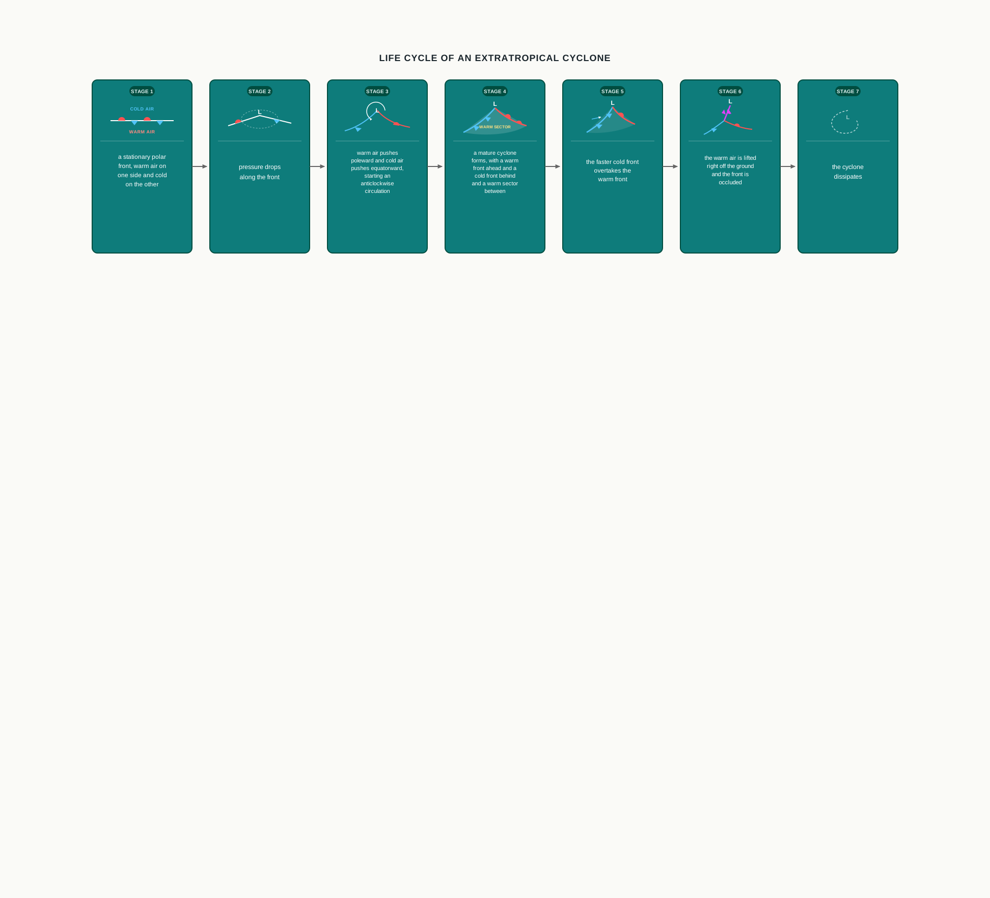
Fig. 9.13 – Lifecycle of an extra tropical cyclone.
The plan and cross section of a fully developed extra tropical cyclone are given in Fig. 9.14, where the surface circulation and the flow high above can be seen to work together.
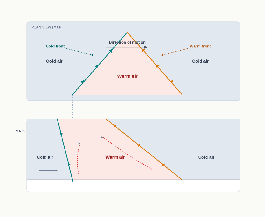
Fig. 9.14 – Plan and cross-section of an extra tropical cyclone.
Set Against The Tropical Cyclone
Both the extra tropical cyclone and the tropical cyclone of the next section are cyclones — low-pressure systems with air spiralling in around the centre — but they are different animals. The extra tropical cyclone has a clear frontal system, with a warm front and a cold front; the tropical cyclone has none. The extra tropical cyclone spreads over a much larger area and can form over both land and sea, whereas the tropical cyclone forms only over the seas and weakens once it reaches land. The tropical cyclone, though smaller, drives much higher wind speeds and does far more damage. And they travel opposite ways: extra tropical cyclones move from west to east, tropical cyclones from east to west.
9.7 Tropical Cyclones
Tropical cyclones are violent storms that are born over the oceans of the tropics and then move onto the coasts, where they cause large-scale destruction through violent winds, very heavy rainfall and storm surges. A storm surge is a wall of sea water pushed ashore by the storm’s winds, and it is among the deadliest parts of the storm. The tropical cyclone is one of the most devastating of all natural calamities. The same storm carries different names in different oceans: Cyclones in the Indian Ocean, Hurricanes in the Atlantic, Typhoons in the western Pacific and the South China Sea, and Willy-willies off western Australia.
Where And How They Form
Tropical cyclones both form and grow stronger over warm tropical oceans. Five conditions favour their birth and intensification. First, a wide sea surface with a temperature above 27 °C, warm enough to feed the storm heavily with water vapour. Second, the presence of the Coriolis force, needed to set the inflowing air spinning — which is why, as you saw earlier, these storms cannot form on the equator where that force is zero. Third, only small changes in wind speed from the bottom of the storm to the top, so the tall cloud column is not torn apart. Fourth, a pre-existing weak low or a low-level cyclonic circulation to build upon. Fifth, air diverging, or spreading out, high above the system, which helps draw air upward from below.
The storm’s energy comes from condensation. As moist air rises and its vapour condenses inside the towering cumulonimbus clouds — the tall thunder clouds ringing the centre — it releases heat, and that heat drives the storm. A continuous supply of moisture from the sea keeps strengthening it. On reaching land the moisture supply is cut off, and the storm dies. The point where a cyclone crosses the coast is its landfall. Cyclones that cross 20° N generally recurve — swing back on their path — and these are more destructive.
Inside A Mature Storm
Fig. 9.15 shows the vertical structure of a mature tropical cyclonic storm. Such a storm is marked by strong, spirally circulating wind wrapped around a centre called the eye. The whole circulating system can measure between 150 and 250 km across.
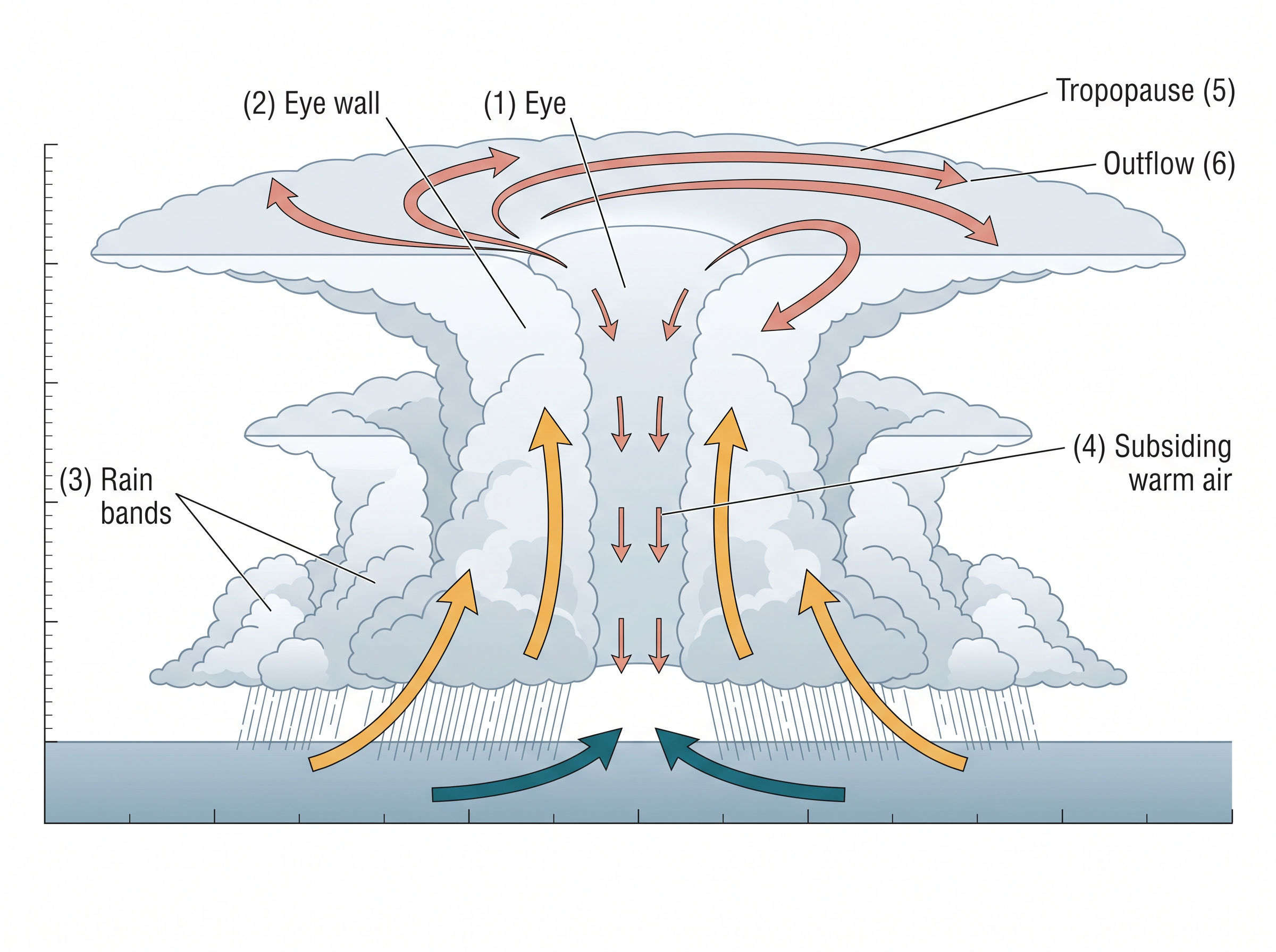
Fig. 9.15 – Vertical section through a mature tropical cyclone.
The eye is a region of calm with sinking air. Wrapped around it is the eye wall, where air spirals violently upward to a great height, reaching the tropopause — the top of the troposphere, the ceiling of the weather layer. The wind is fastest here, reaching as high as 250 km per hour, and torrential rain falls. From the eye wall, spiral rain bands radiate outward, and trains of cumulus and cumulonimbus clouds drift into the outer region.
Over the Bay of Bengal, the Arabian Sea and the Indian Ocean, the whole storm spans between 600 and 1200 km, and it moves slowly, only about 300 to 500 km per day. As it comes ashore it drives storm surges that flood the low-lying coast, before the storm finally peters out over land.
Two full days of violent wind and torrential rain over one stretch of coast — that is what those two numbers mean when read together. A storm that is wider, or slower, holds a place under siege for even longer. Added to the wind is the storm surge flooding the low ground, so for the people living along that coast the danger is counted in days, not hours, and reaches well inland of the shoreline.
9.8 Thunderstorms and Tornadoes
The last of the chapter’s storms are the smallest and shortest-lived, but no less violent. Thunderstorms and tornadoes are severe local storms: they last only a short while and strike a small area, yet within it they are ferocious.
How A Thunderstorm Grows
A thunderstorm is caused by intense convection on a hot, moist day. The result is a well-grown cumulonimbus cloud producing thunder and lightning. At its heart is an updraft — a powerful column of warm air rising fast — which makes the cloud swell and climb to great height. As the cloud grows, precipitation forms and falls. Later a downdraft, a current of sinking air, drags the cooled air and the rain back down to the ground.
What the storm produces at the ground depends on its conditions. When the cloud reaches heights where the temperature is below 0 °C, water freezes into ice, and it comes down as a hailstorm. When there is too little moisture instead, the storm can raise a dust-storm. And from a severe thunderstorm a spiralling wind sometimes descends to the ground like the trunk of an elephant, with very low pressure at its centre, causing massive destruction along its path. This is a tornado. Tornadoes generally occur in the middle latitudes, and a tornado that forms over the sea is called a water spout.
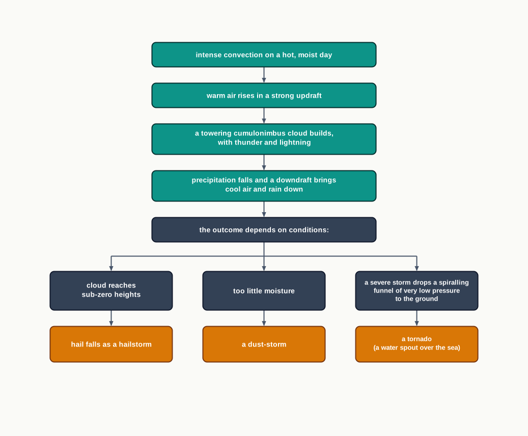
Fig. 9.16 – Outcomes of a severe thunderstorm.
All these violent storms are the atmosphere adjusting itself to an uneven spread of energy. In each of them, potential and heat energy are converted into kinetic energy — the energy of motion — and once that release is spent, the restless atmosphere settles back toward its stable state.
9.9 Summary
- Atmospheric pressure is the weight of a column of air over a unit area, from sea level to the top of the atmosphere. It is measured in millibars, averages 1,013.2 mb at sea level, and falls with height — roughly 1 mb for every 10 m.
- Pressure also varies from place to place. Isobars, drawn after readings are reduced to sea level, map this horizontal variation, and it is the difference in pressure that sets air moving as wind.
- Averaged over the globe, pressure forms belts — the equatorial low, the subtropical highs near 30°, the sub polar lows near 60° and the polar highs — which shift north and south with the Sun through the seasons.
- Near the surface, wind is shaped by three forces acting together: the pressure gradient force, the frictional force and the Coriolis force, with gravity pulling downward.
- The Coriolis force turns wind to the right in the northern hemisphere and to the left in the southern, is strongest at the poles and zero at the equator — which is why tropical cyclones cannot form on the equator itself.
- High above the surface, where friction is absent and the pressure gradient force and Coriolis force balance, the wind blows parallel to straight isobars as the geostrophic wind.
- Air converges and rises over a low, giving cloud and rain, and sinks and diverges over a high. Winds circle a low as cyclonic circulation and a high as anti cyclonic circulation.
- The general circulation runs in three cells in each hemisphere — the Hadley, Ferrel and polar cells — which carry heat poleward and also drive slow ocean currents. Shifts in the Pacific, the El Nino–southern oscillation (ENSO), can throw weather off around the world.
- Seasonal shifts of the belts give the monsoon, while differences in heating raise local winds — land and sea breezes, valley and mountain winds, the cold katabatic wind and warm winds descending a lee slope.
- An air mass takes on the temperature and moisture of the uniform source region over which it forms. Five types are recognised: maritime tropical, continental tropical, maritime polar, continental polar and continental arctic.
- Where two different air masses meet, a front forms. There are four kinds — stationary, cold, warm and occluded — and along each the warm air is lifted over the cold, bringing cloud and rain.
- Extra tropical cyclones form on the polar front in the middle and high latitudes, carry a warm and a cold front, die once occluded, and move from west to east.
- Tropical cyclones form only over seas warmer than 27 °C, with the Coriolis force and a seed low. They run on the heat released by condensation, have a calm eye ringed by a violent eye wall, weaken on land, and move from east to west.
- Thunderstorms, built on a rising updraft and closed by a downdraft, can bring hail or a dust-storm; tornadoes are their most violent offspring. Such storms convert the atmosphere’s uneven energy into motion and let it return to a stable state.
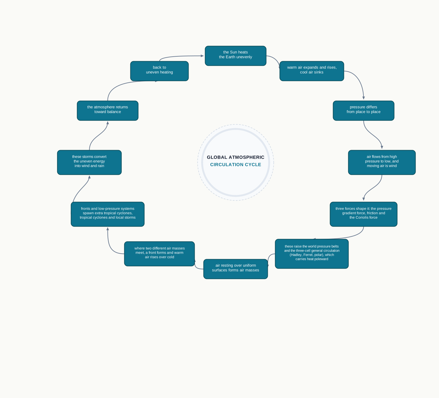
Fig. 9.17 – The atmospheric circulation and weather chain.
What This Chapter Cannot Tell You
The standard atmosphere in Table 9.1 and the neat three-cell diagram are idealised averages; the real air over any place, on any day, departs from them, because the continents and the seasons break the tidy pattern. A January or July pressure map is a single month’s average — it smooths away the day-to-day weather and the individual storms that ride through. And while the chapter names the conditions that allow a cyclone to form, it cannot say when or exactly where the next one will strike; that needs live measurement and forecasting, not a model on a page.
9.10 NCERT Questions
If the surface air pressure is 1,000 mb, the air pressure at 1 km above the surface will be:
- 700 mb
- 1,100 mb
- 900 mb
- 1,300 mb
The Inter Tropical Convergence Zone normally occurs:
- near the Equator
- near the Tropic of Cancer
- near the Tropic of Capricorn
- near the Arctic Circle
The direction of wind around a low pressure in northern hemisphere is:
- clockwise
- perpendicular to isobars
- anti-clock wise
- parallel to isobars
Which one of the following is the source region for the formation of air masses?
- the Equatorial forest
- the Himalayas
- the Siberian Plain
- the Deccan Plateau
What is the unit used in measuring pressure? Why is the pressure measured at station level reduced to the sea level in preparation of weather maps? (30 words)
While the pressure gradient force is from north to south, i.e. from the subtropical high pressure to the equator in the northern hemisphere, why are the winds north easterlies in the tropics? (30 words)
What are the geostrophic winds? (30 words)
Explain the land and sea breezes. (30 words)
Discuss the factors affecting the speed and direction of wind. (150 words)
Draw a simplified diagram to show the general circulation of the atmosphere over the globe. What are the possible reasons for the formation of subtropical high pressure over 30° N and S latitudes? (150 words)
Why does tropical cyclone originate over the seas? In which part of the tropical cyclone do torrential rains and high velocity winds blow and why? (150 words)
9.11 Check Your Concepts
An air mass is labelled ‘cP’. From its name alone, state the kind of surface it formed over and whether it is warm or cold.
In a cold front and in a warm front, name the air mass that is the one advancing in each case.
Using Table 9.1, work out by how many millibars the pressure falls between sea level and 5 km.
Compare Fig. 9.2 and Fig. 9.3 and describe how the position of the ITCZ shifts between January and July. What causes this shift?
Explain why a tropical cyclone cannot form on the equator itself, even though the sea there is warm.
Place the stages of an extra tropical cyclone in order, from the stationary polar front to the storm’s dissipation.
Contrast an extra tropical cyclone with a tropical cyclone on three points the chapter makes: their frontal system, where each forms, and the direction each travels.
Table 9.1 describes a ‘standard atmosphere’. Give one reason the real pressure over a place on a given day might not match the value in the table.