Chapter 4: Distribution Of Oceans And Continents
Look at a globe and find the country you live in. It feels like the most solid, unmoving thing there is — the very definition of firm ground. Yet the rock beneath your feet is on a journey, and it has been travelling for a very long time.
Around two hundred million years ago, the land that is now India was not in the northern hemisphere at all. It lay far to the south, a large island in a warm ocean, closer to the frozen edge of the world than to Asia. Then, slowly — a few centimetres in a year, no faster than a fingernail grows — it began to move north.
It did not drift alone. India was riding on a vast slab of the Earth’s outer shell, and that slab carried it thousands of kilometres across a vanishing ocean. When its leading edge finally met the underside of Asia, the two masses could go no further. The crust buckled and rose, and the wrinkle it threw up is the tallest mountain range on Earth. That collision has never quite stopped. India is still pushing north, and the mountains are still, very slowly, rising.
The obvious question is how anyone could possibly know all this. No one was there to watch it happen. This chapter is the answer to that question.
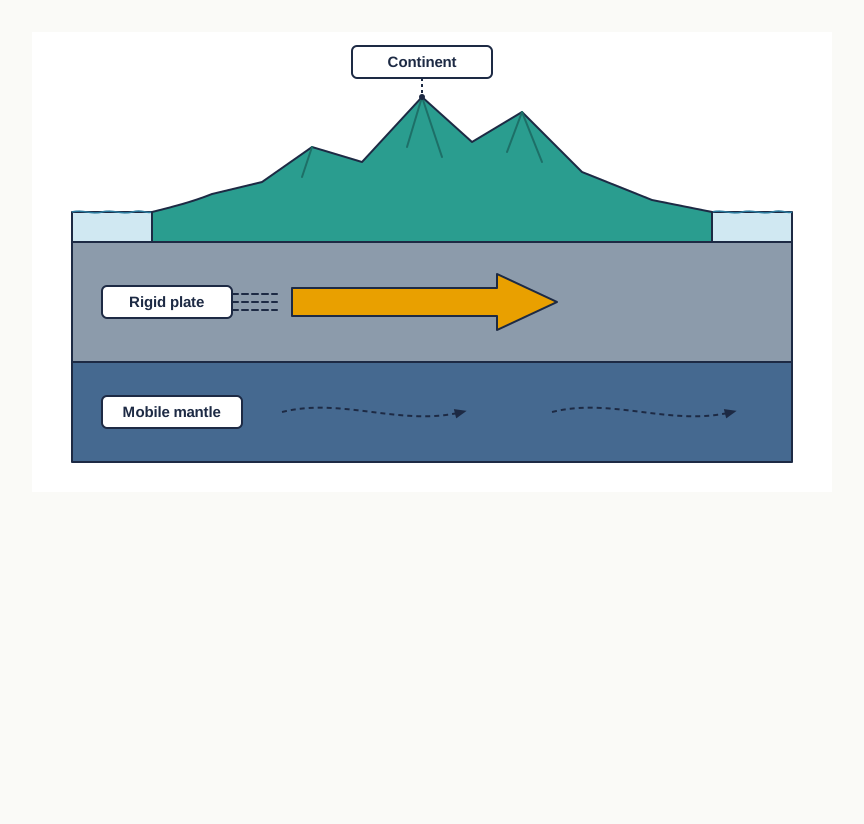
Fig. 4.0 – Continent riding on a tectonic plate.
Hold these questions as you read. By the end of the chapter, you will be able to answer every one of them.
4.1 Continental Drift
Continents cover 29 per cent of the surface of the earth, and oceanic water covers the rest. When you look at a world map, that arrangement of land and sea feels fixed and permanent. It is not. The continents and the oceans have not always sat where they sit now, and it is now widely accepted that they will not stay in these positions in the future either.
This raises a chain of questions. Where were the continents in the past? Why do they change position at all, and how? And since nobody was present to watch the movement, how have scientists worked out where the land used to be? This chapter answers these questions, beginning with the first serious attempt to explain the wandering of continents.
Reading The Atlantic
Look closely at the coastline on the two sides of the Atlantic Ocean. The eastern edge of the Americas and the western edge of Europe and Africa are strikingly similar in shape, almost as though they had been torn apart. Many observers noticed this symmetry and wondered whether the two Americas, Europe and Africa had once been joined.
From the records of science, it was Abraham Ortelius, a Dutch map maker, who first suggested this possibility, as early as 1596. Antonio Pellegrini later drew a map that placed the three continents together. But the full, reasoned case was made by Alfred Wegener, a German meteorologist, who in 1912 put forward the ‘continental drift theory’ to explain how the oceans and continents are distributed. Continental drift is the idea that the continents have slowly moved across the surface of the earth over vast stretches of time.
Pangaea And Its Break-Up
According to Wegener, all the present continents were once fused into one enormous landmass, ringed by a single ocean. He named the supercontinent Pangaea, a word meaning all earth, and the surrounding mega-ocean Panthalassa, meaning all water. He argued that around 200 million years ago Pangaea began to split apart.
Pangaea first broke into two large masses. The northern one was Laurasia and the southern one Gondwanaland. These two masses then continued to fragment, and their pieces became the separate continents we know today. Wegener supported this claim with several independent lines of evidence, set out in the sections below.
The whole sequence is easier to hold in mind as a single branching chain.
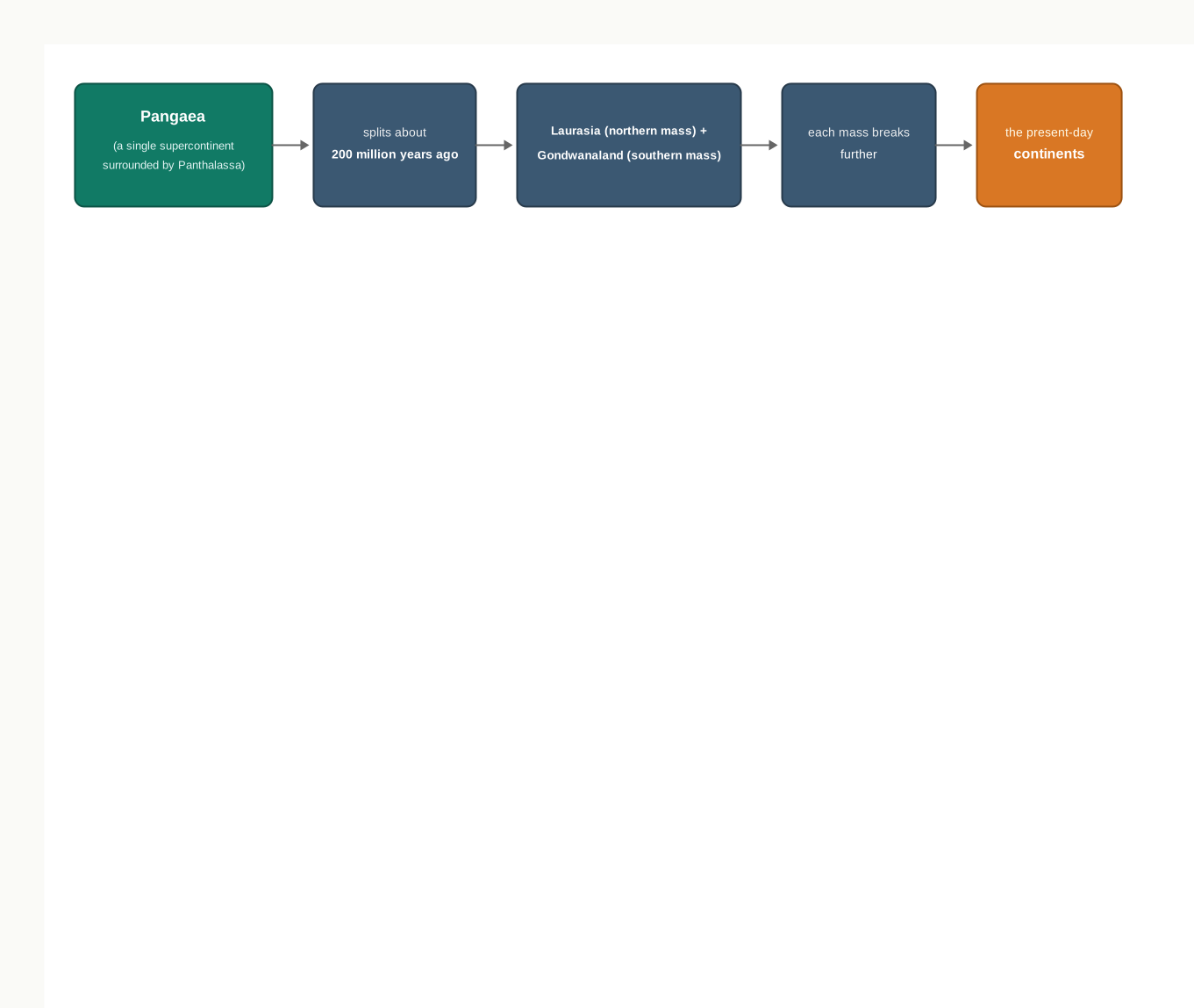
Fig. 4.1 – Break-up of Pangaea.
4.1.1 Evidence In Support Of The Continental Drift
No single observation proves that continents have moved. Wegener’s case rests instead on several separate matches across the oceans, each of which is hard to explain unless the lands were once joined.
4.1.1.1 The Matching Of Continents (Jig-Saw-Fit)
The shorelines of Africa and South America that face each other across the Atlantic show a remarkable and unmistakable match. This is the most obvious piece of evidence: the two coasts look like adjoining pieces of a jigsaw puzzle.
The match is more than a rough impression. In 1964 Bullard used a computer programme to find the best fit of the Atlantic margins, and the fit proved to be nearly perfect. Importantly, the match was made not at the present shoreline but at the 1,000-fathom line — a depth contour well below the visible coast (a fathom is an old unit of water depth, about 1.8 metres). That deeper line marks the true structural edge of a continent, out where the land really ends beneath the sea.
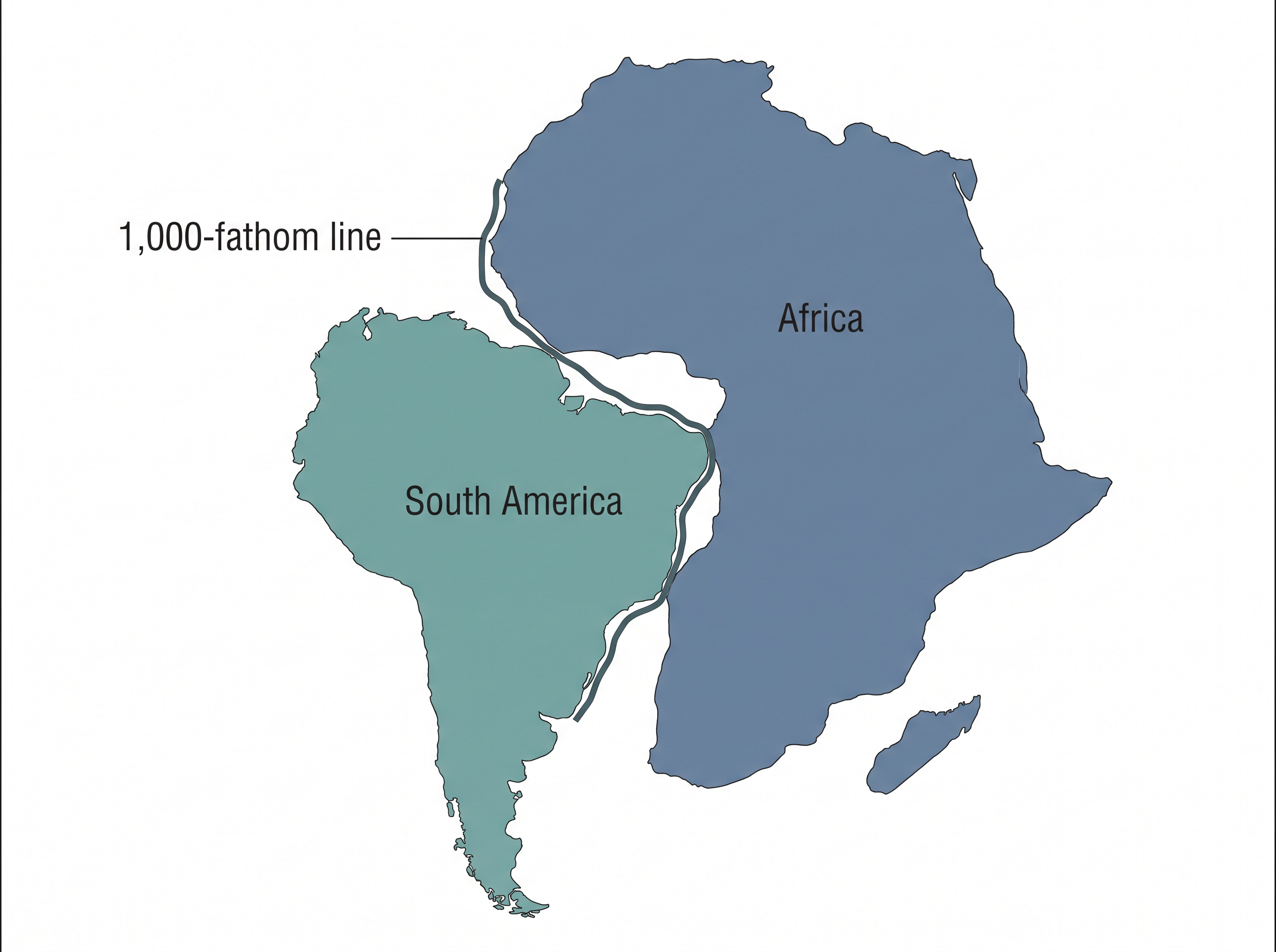
Fig. 4.2 – Jig-saw fit of Africa and South America.
4.1.1.2 Rocks Of Same Age Across The Oceans
Coastlines can match by chance, but rocks are harder to fake. Radiometric dating — working out the age of a rock from the steady, clock-like decay of radioactive elements inside it — has allowed geologists to compare rock formations on continents that now lie far apart.
The results line up. A belt of ancient rocks about 2,000 million years old on the coast of Brazil, in South America, matches a belt of the same age in western Africa. If two rock belts of identical age and character run straight into the sea on facing coasts, the simplest explanation is that they were once a single belt, later split by the widening ocean.
The age of the ocean itself can be read the same way. The earliest marine deposits along the coasts of South America and Africa belong to the Jurassic age. Since no older sea-laid rock is found there, the ocean between the two continents did not exist before that time — it opened only after the land began to part.
4.1.1.3 Tillite
Tillite is a sedimentary rock formed from the deposits left behind by glaciers. Its presence is a fingerprint of past ice. The Gondwana system of sediments from India is known to have counterparts in six different landmasses of the Southern Hemisphere, and at the base of that system lies thick tillite, the sign of extensive and prolonged glaciation.
Counterparts of this same succession are found in Africa, Falkland Island (in the South Atlantic off South America), Madagascar (the large island off Africa’s southeast coast), Antarctica and Australia. The strong resemblance of Gondwana-type sediments shows that these widely scattered landmasses once shared remarkably similar histories. The glacial tillite is therefore firm evidence both of ancient climates, or palaeoclimates, and of the drifting of continents.
4.1.1.4 Placer Deposits
There are rich placer deposits of gold along the coast of Ghana, in West Africa, yet there is no source rock for gold anywhere in that region. Placer deposits are grains of a heavy mineral, here gold, washed loose and concentrated by water far from the rock they came from.
The puzzle solves itself once the continents are put back together. The gold-bearing veins that could have supplied those grains lie in the plateau of Brazil, across the Atlantic. The obvious conclusion is that Ghana’s gold was shed from the Brazil plateau at a time when the two coasts lay directly side by side.
4.1.1.5 Distribution Of Fossils
When the same species of plant or animal — one adapted to live on land or in fresh water — turns up on both sides of a wide ocean, a problem arises: such a creature could not have swum or walked across salt water to reach the far shore. The distribution has to be explained some other way.
Two examples make the point. Lemurs occur in India, Madagascar and Africa, and this shared distribution led some to imagine a now-vanished connecting landmass, which they called ‘Lemuria’, linking the three. More telling still is Mesosaurus, a small reptile suited only to shallow brackish water, never the open sea. Its skeletons are found in just two places on earth: the Southern Cape province at the southern tip of South Africa, and the Iraver formations of Brazil. These two localities now lie 4,800 km apart with an entire ocean between them — a gap this little reptile could never have crossed unless the two lands were once joined.
4.1.2 Force For Drifting
Wegener still had to explain what could push whole continents around, and here his theory was weakest. He suggested two forces. The first was the pole-fleeing force, which relates to the rotation of the earth. The earth is not a perfect sphere; its spin makes it bulge at the equator, and Wegener thought this rotational effect could drive continents away from the poles.
The second was the tidal force, produced by the pull of the moon and the sun on the earth, the same pull that raises tides in the oceans. Wegener believed that both forces, though gentle, would add up to something powerful if they acted steadily over many millions of years.
Most scholars disagreed. They judged these forces to be far too weak to shift continents, and this was the fatal flaw in Wegener’s case. His evidence was persuasive, but without a believable engine the theory could not stand.
4.2 Post-Drift Studies
Notice where all of Wegener’s evidence came from. The matching coastlines, the shared rock belts, the tillite, the transported gold, the stranded fossils — every one of them was gathered from the continents, from the distribution of plants, animals and deposits on land. The ocean floor, which covers most of the planet, had contributed almost nothing, because almost nothing was known about it.
That changed after the Second World War. A run of discoveries in the post-war period added a great deal to geological knowledge, and the most important of them came from mapping the floor of the oceans. This new information gave the whole question of drifting continents a fresh dimension, and it eventually supplied the two things Wegener’s theory had lacked: a believable force, and direct evidence from the sea floor itself.
4.2.1 Convectional Current Theory
The theory had been set aside for want of a force strong enough to move continents. In the 1930s, Arthur Holmes offered a candidate. He discussed the possibility that convection currents operate deep inside the mantle — the thick, hot layer of the earth that lies between the thin crust and the core.
A convection current is the slow circulation that arises when part of a fluid or soft solid is heated: the hot material rises, spreads sideways, cools, sinks again, and the loop repeats. Holmes reasoned that radioactive elements scattered through the mantle release heat as they decay, and that this heat produces temperature differences from place to place. Those differences, he argued, drive a system of convection currents through the entire mantle. Here at last was a possible engine — an attempt to answer the very force problem on which scientists had rejected the drift theory.
4.2.2 Mapping Of The Ocean Floor
Detailed study of the ocean’s shape overturned an old assumption. The sea floor is not a flat, featureless plain; it is full of relief. Post-war expeditions that surveyed the ocean bottom revealed submerged mountain ranges and deep trenches — long, narrow gashes in the floor — most of them lying closer to the margins of the continents.
Two findings from this mapping matter most for our story. First, the mid-oceanic ridges — great underwater mountain chains running along the ocean floor — turned out to be the most volcanically active places on earth. Second, when the rocks of the oceanic crust were dated, they proved to be far younger than the rocks of the continents.
There was a further, stranger pattern. Rocks taken from either side of the crest of an oceanic ridge, at equal distances from that crest, were remarkably alike — both in what they were made of and in how old they were. A matched pair on the left and the right of a ridge shared the same age. That symmetry is not what you would expect of an old, settled sea floor, and it became a central clue.
4.3 Ocean Floor Configuration
To understand how oceans and continents are arranged, it helps to know the shape of the floor beneath the sea. This section notes only a few features of that floor; its full relief is the subject of a later chapter. Here the aim is simply to see how the ocean bottom is organised.
Based on depth and on the kind of relief they carry, the ocean floor can be split into three major divisions: the continental margins, the deep-sea basins, and the mid-ocean ridges. The overall profile, from the highest land down to the deepest trench, is shown in Fig. 4.3.
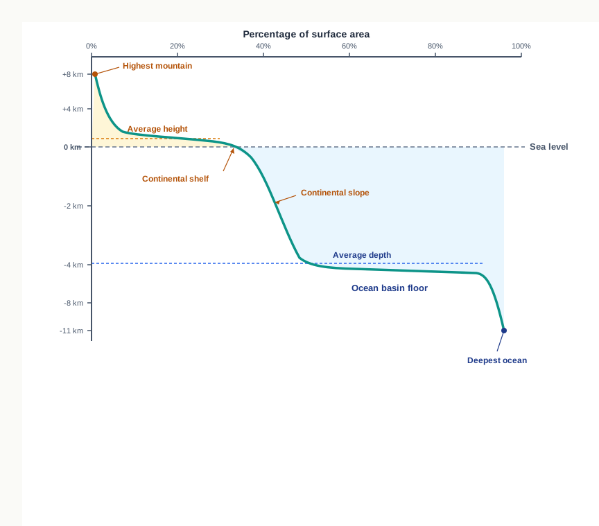
Fig. 4.3 – Hypsometric profile of the ocean floor.
4.3.1 Continental Margins
The continental margins form the transition between the shores of a continent and the deep-sea basins beyond. They are not one feature but four, running from the shallow edge nearest the coast down into deep water: the continental shelf, the continental slope, the continental rise and, deepest of all, the deep-oceanic trenches.
Of these four, the deep-oceanic trenches are the ones to watch. They matter most for the question of how oceans and continents are distributed, and they will return later in the chapter as the places where the ocean floor is destroyed.
4.3.2 Abyssal Plains
Beyond the margins lie the deep-sea basins, and their most extensive feature is the abyssal plains — broad, flat stretches of ocean floor that spread between the continental margins and the mid-oceanic ridges. They are the calmest, most level surfaces on the planet.
They are level because they are made of settled dust. The sediment that washes off the continents and travels out past the margins finally comes to rest here, layer upon layer, smoothing the deep floor into a plain.
4.3.3 Mid-Oceanic Ridges
The third division is the most dramatic. The mid-oceanic ridges form a single interconnected chain of mountains running through the oceans, and taken together they make up the longest mountain-chain on the surface of the earth — though almost none of it is ever seen, because it lies submerged beneath the sea.
Along its whole length the ridge has a distinct build: a central rift system at the very crest, flanked by a fractionated plateau and a flank zone on either side. A rift is a long crack where the crust is being pulled apart, and this rift at the crest is a zone of intense volcanic activity. It is the source of the mid-oceanic volcanoes met in the previous chapter — volcanoes that erupt not on land but along the floor of the deep sea.
The whole configuration can be gathered into one branching picture.
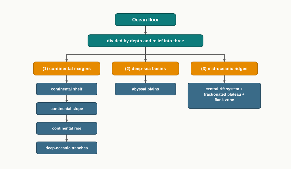
Fig. 4.4 – Divisions of the ocean floor.
4.4 Distribution Of Earthquakes And Volcanoes
Earthquakes and volcanoes are not scattered evenly over the earth. They cluster along a few narrow belts, and the shape of those belts is one of the most important clues in this whole chapter. Seismic activity — the shaking of the ground caused by earthquakes — and volcanic eruptions turn out to trace the same lines across the globe.
Study the pattern in Fig. 4.5. A line of dots runs down the central parts of the Atlantic Ocean, almost parallel to the coastlines on either side. It carries on into the Indian Ocean and then bifurcates a little south of the Indian subcontinent: one branch swings into East Africa, and the other runs on to meet a similar line reaching from Myanmar to New Guinea. This whole line of dots coincides exactly with the mid-oceanic ridges. Alongside it, a broad shaded belt marks a second zone of concentration, one that follows the Alpine-Himalayan mountain system — the chain of young mountains running from the Alps of Europe to the Himalayas of Asia — and continues around the rim of the Pacific Ocean.
Map
Fig. 4.5 Caption: Distribution of earthquakes and volcanoes. Brief: world map plotting seismic and volcanic activity; key must show deep earthquake zones (shaded belts), shallow earthquake centres, volcanic eruptions and hot spots; show the line of activity running down the mid-Atlantic and into the Indian Ocean, its bifurcation south of the Indian subcontinent (one branch to East Africa, one toward Myanmar and New Guinea), the shaded belt along the Alpine-Himalayan system and around the Pacific rim (the ring of fire), and marked hot spots such as Yellowstone, Hawaii and Galapagos; include the printed scale bar. Show the full extent of India as officially defined.
Shallow And Deep, Two Kinds Of Belt
The two belts differ not only in shape but in depth. The focus of an earthquake is the point inside the earth where the rupture begins, and the depth of that focus varies from place to place. Along the mid-oceanic ridges, the foci are generally shallow, lying close to the surface. Along the Alpine-Himalayan belt and the rim of the Pacific, by contrast, the earthquakes are deep-seated, with their foci far below the ground.
The map of volcanoes shows a matching pattern, tracing the same lines and belts. So closely do active volcanoes ring the Pacific that this belt has earned its own name: the rim of the Pacific is called the ring of fire. The map also marks scattered volcanic hot spots away from the belts, at places such as Yellowstone, Hawaii and Galapagos.
None of this is coincidence. Two facts — that the shallow line follows the mid-oceanic ridges, and that the deep belt follows the great mountain chains and ocean-rim trenches — will soon become the strongest evidence for how the ocean floor spreads and how the earth’s outer shell is broken into moving plates.
4.5 Concept Of Sea Floor Spreading
The post-drift studies handed scientists a mass of information that Wegener never had. Two lines of work mattered most: the mapping of the ocean floor, and palaeomagnetic studies of the rocks taken from beneath the oceans. Palaeomagnetism is the record of the earth’s magnetic field frozen into a rock at the moment it forms — a kind of built-in compass needle, locked in place. Together these two approaches revealed a set of facts that pointed clearly in one direction.
What The Ocean Floor Revealed
First, volcanic eruptions are common all along the mid-oceanic ridges, pouring huge amounts of lava onto the sea floor in these zones. The ridges are not quiet mountains; they are lines of near-constant eruption.
Second, the rocks lying at equal distances on the two sides of a ridge crest are strikingly alike — in when they formed, in their chemical make-up and in their magnetic properties. The rocks nearest the crest are the youngest, and they carry normal polarity, meaning they are magnetised in the same direction as the earth’s field today. As you move away from the crest, the rocks steadily grow older.
Third, the rocks of the oceanic crust are much younger than those of the continents. Nowhere is oceanic crust more than 200 million years old, whereas some continental rock formations are as old as 3,200 million years.
Fourth, the layer of sediment on the ocean floor is unexpectedly thin. If the sea floor were truly as old as the continents, scientists expected to find a thick, complete pile of sediment built up over an enormous span of time. Instead, nowhere was the sediment column found to be older than 200 million years — far too little for an ancient floor.
Fifth, the deep trenches suffer deep-seated earthquakes, while the mid-oceanic ridge areas have only shallow-focus quakes — the same split between the two belts seen in the distribution map earlier.
Hess And Sea Floor Spreading
These facts, together with a close study of the magnetic properties of rocks on either side of the ridges, led Hess to propose his hypothesis in 1961, which he called sea floor spreading: the idea that new ocean floor is created at the mid-oceanic ridges and slowly carried outward.
Hess argued that the constant eruptions at the crest of the ridges rupture the oceanic crust, and that fresh lava wedges into the split. As it does, it pushes the older crust away on both sides. In this way the ocean floor spreads. The basic idea is shown in Fig. 4.6.
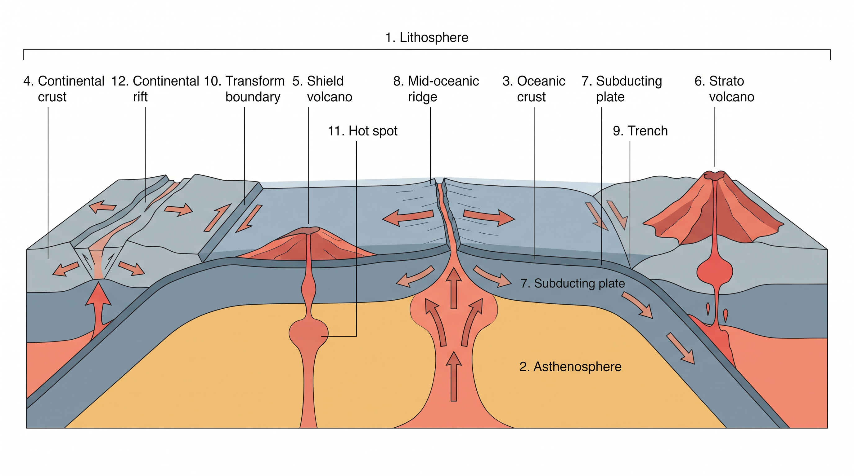
Fig. 4.6 – Sea floor spreading and plate boundaries.
If new floor is made without end, something must give — otherwise the earth would keep swelling. Two clues told Hess what happens. The oceanic crust is young everywhere, and the spreading of one ocean does not shrink any other. Both pointed to the same answer: the old floor must be destroyed somewhere. Hess concluded that the crust pushed outward from the ridge eventually reaches the deep trenches, where it sinks down and is consumed.

Fig. 4.7 – The cycle of ocean floor creation and destruction.
4.6 Plate Tectonics
Sea floor spreading explained how the ocean floor is made and destroyed, and it revived interest in the whole question of moving continents. In 1967, McKenzie and Parker, and independently Morgan, gathered the available ideas into a single, more powerful theory, which they termed plate tectonics.
What A Plate Is
A tectonic plate, also called a lithospheric plate, is a massive, irregularly shaped slab of solid rock, made up of both continental and oceanic lithosphere. The lithosphere is the rigid outer shell of the earth — the crust together with the topmost part of the mantle. Its thickness varies, from between 5 and 100 km under the oceans to about 200 km under the continents.
These slabs do not stay still. Plates move horizontally, as rigid units, over the asthenosphere — the hotter, softer layer of the mantle just below the lithosphere, on which the plates can slide. A plate is called a continental plate or an oceanic plate depending on which kind of lithosphere makes up the larger part of it. The Pacific plate, for instance, is largely oceanic, while the Eurasian plate may be called continental.
The World’s Plates
The theory holds that the earth’s lithosphere is broken into seven major plates and a number of smaller ones. Young fold-mountain ridges, trenches and faults trace the edges of the major plates, as shown in Fig. 4.8.
Map
Fig. 4.8 Caption: Major and minor plates of the world. Brief: world map showing the seven major plates and the named minor plates, with boundaries drawn by type — divergent, convergent and transform — as given in the printed key; label the Eurasian, North American, South American, Pacific, Indo-Australian, African and Antarctic plates, and the Cocos, Nazca, Arabian, Philippine, Caroline, Juan de Fuca and Scotia plates; mark the Mid-Atlantic Ridge, the East Pacific Rise, the San Andreas Fault, the Aleutian Trench and the Java Trench; include the printed scale bar. Show the full extent of India as officially defined.
The seven major plates are:
I. Antarctica and the surrounding oceanic plate. II. The North American plate, with the western Atlantic floor separated from the South American plate along the Caribbean islands. III. The South American plate, with the western Atlantic floor separated from the North American plate along the Caribbean islands. IV. The Pacific plate. V. The India-Australia-New Zealand plate. VI. Africa, with the eastern Atlantic floor plate. VII. Eurasia and the adjacent oceanic plate.
Among the important minor plates are the Cocos plate, between Central America and the Pacific plate; the Nazca plate, between South America and the Pacific plate; the Arabian plate, mostly the Saudi Arabian landmass; the Philippine plate, between the Asiatic and Pacific plates; and the Caroline plate, between the Philippine and Indian plates, north of New Guinea.
What Actually Moves
Here plate tectonics makes a crucial correction to Wegener. It is not the continent that moves on its own, as Wegener believed. A continent is simply part of a plate, and what moves is the whole plate, carrying the continent along like a passenger. Every plate, without exception, has moved in the geological past and will keep moving in the future.
This changes the story of Pangaea too. Wegener imagined that all the continents began as one supercontinent. Later work shows instead that the continental masses, riding on their plates, have wandered throughout geological time, and that Pangaea itself was not the beginning — it was a temporary gathering, formed when different continental masses, carried on different plates, happened to converge.
Scientists have reconstructed where each landmass sat in different geological periods using palaeomagnetic data, the frozen-compass record inside the rocks. The changing positions are shown in Fig. 4.9. The position of the Indian subcontinent, mostly Peninsular India, has been traced in this way from rocks analysed from the Nagpur area, in central India.
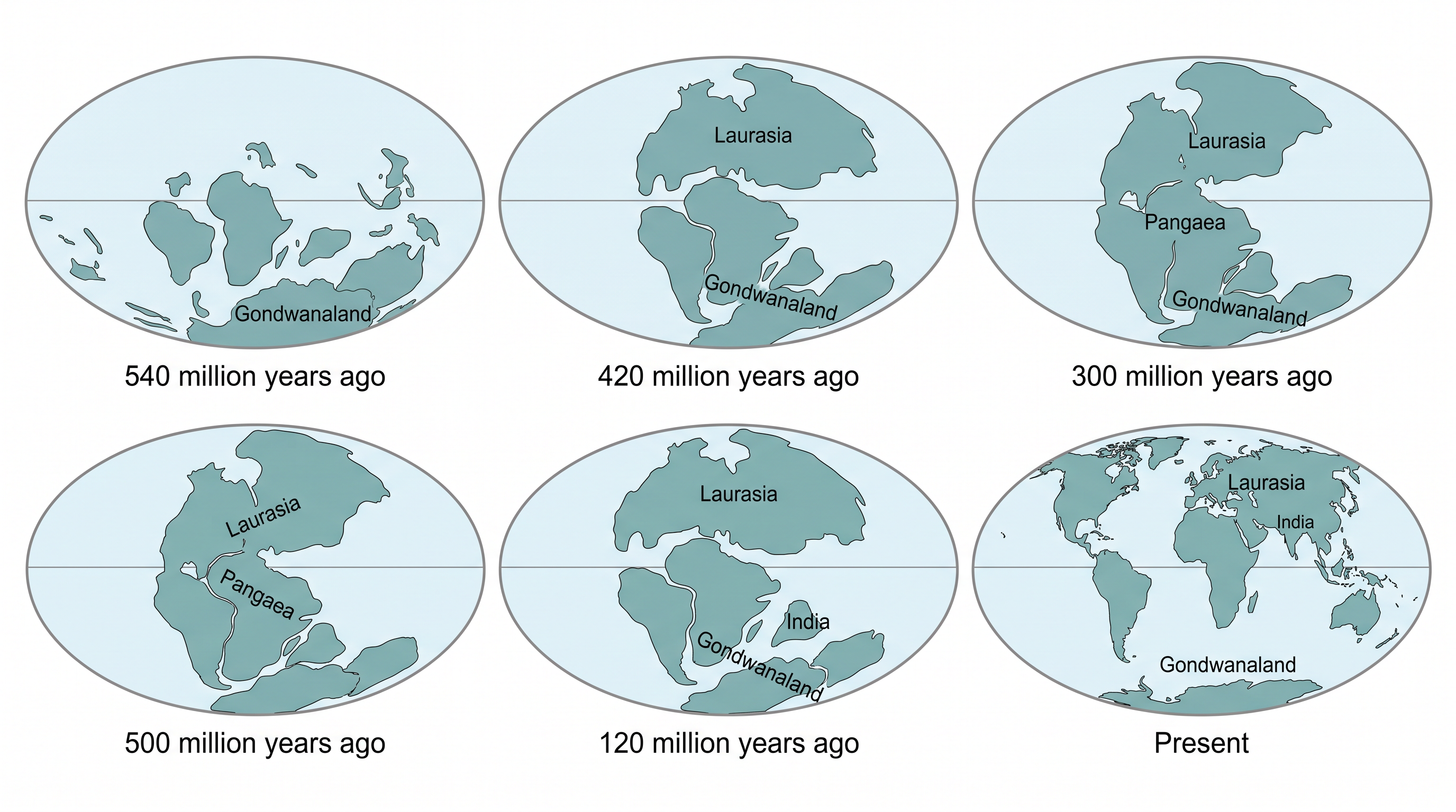
Fig. 4.9 – Continents through the geological past.
Where two plates meet, they do one of three things. There are three types of plate boundary.
4.6.1 Divergent Boundaries
At a divergent boundary, new crust is generated as two plates pull away from each other. The places where plates move apart are called spreading sites. The best-known example is the Mid-Atlantic Ridge, where the American plates are separating from the Eurasian and African plates — the very ridge where sea floor spreading was first worked out.
4.6.2 Convergent Boundaries
At a convergent boundary, crust is destroyed as one plate dives beneath another. The place where a plate sinks and is swallowed is called a subduction zone. Convergence can happen in three ways: between an oceanic and a continental plate, between two oceanic plates, and between two continental plates.
4.6.3 Transform Boundaries
At a transform boundary, crust is neither produced nor destroyed; the two plates simply slide horizontally past each other. Transform faults are the planes of separation, running roughly at right angles to the mid-oceanic ridges. Because eruptions do not occur all along a ridge crest at once, one portion of a plate moves differently from the next, and this differential movement, together with the effect of the earth’s rotation on the separated blocks, produces these sideways-sliding boundaries.
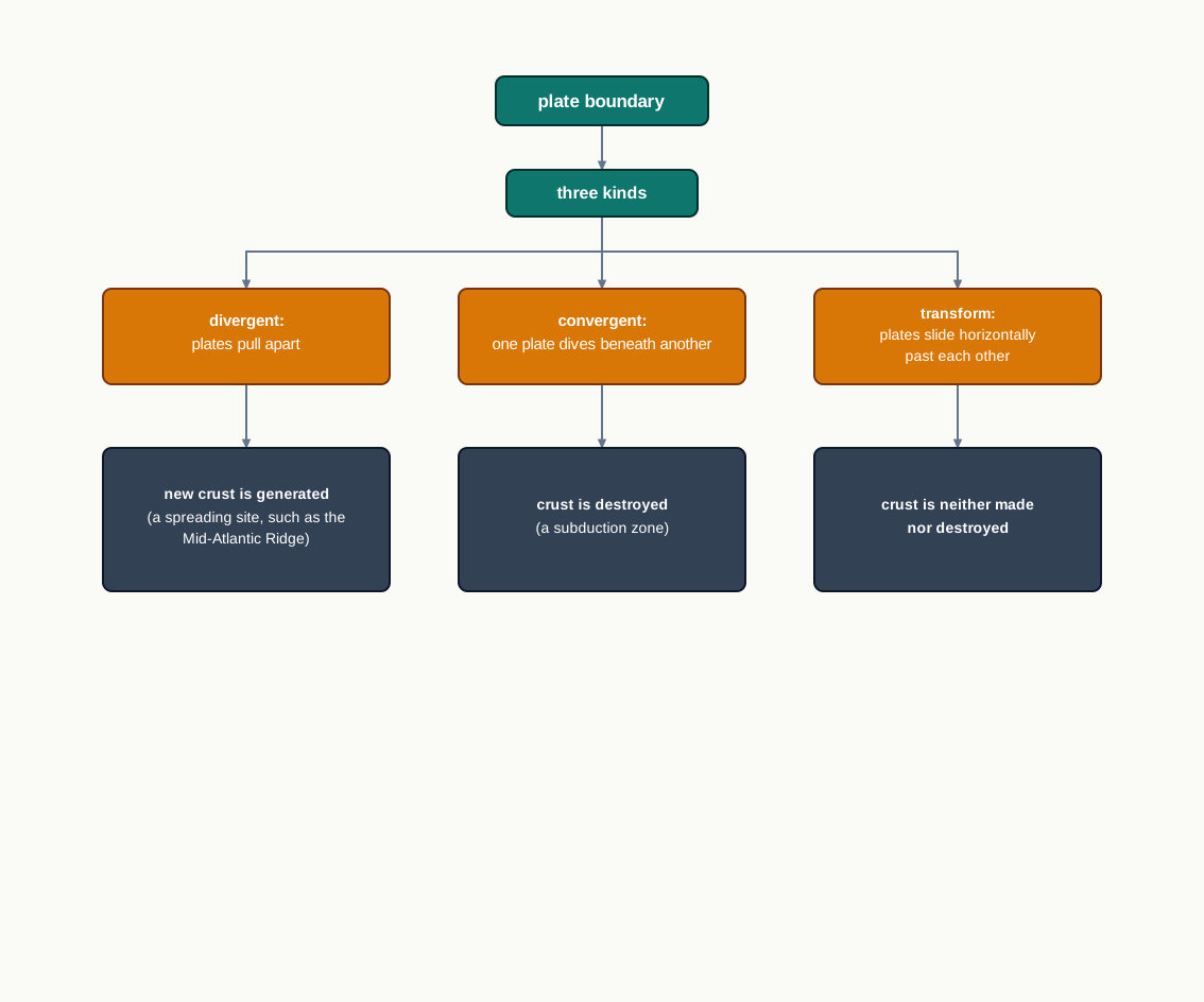
Fig. 4.10 – Types of plate boundary.
4.6.4 Rates Of Plate Movement
Plates do not all travel at the same speed. Their rates are read from the strips of normal and reverse magnetic field that run parallel to the mid-oceanic ridges, and these rates vary considerably. The Arctic Ridge, in the Arctic Ocean, has the slowest rate, less than 2.5 cm per year. The fastest is the East Pacific Rise near Easter Island, in the South Pacific about 3,400 km west of Chile, where the rate is more than 15 cm per year.
4.6.5 Force For The Plate Movement
When Wegener first proposed drift, most scientists pictured the earth as a solid, motionless body — and that is why his theory failed. Sea floor spreading and the unified theory of plate tectonics overturned that picture: both the surface and the interior of the earth are now known to be dynamic, not static. That the plates move is a well-accepted fact. The question is what drives them.
The answer lies in the mobile rock beneath the rigid plates, which moves in a slow, circular fashion. Heated material rises toward the surface, spreads sideways, cools, and then sinks back into deeper depths, only to be heated and rise again. Repeated over and over, this circulation is what scientists call a convection cell, or convective flow. The heat that powers it comes from two main sources: radioactive decay, and residual heat left over from the earth’s formation.
This was the very idea Arthur Holmes first raised in the 1930s, which later shaped Harry Hess’s thinking about sea floor spreading. The slow movement of the hot, softened mantle below the rigid plates is the driving force behind all plate movement.
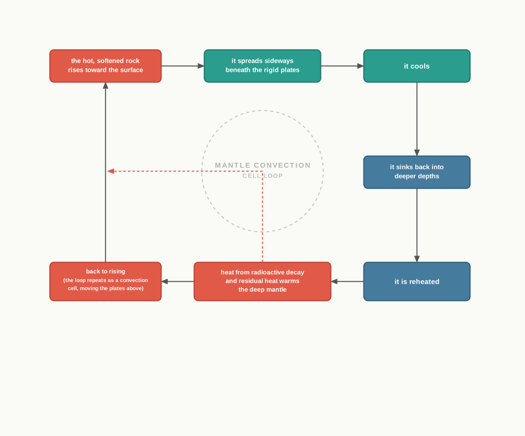
Fig. 4.11 – Convection cell in the mantle.
4.7 Movement Of The Indian Plate
The chapter’s ideas come together in the story of the plate beneath our own feet. The Indian plate carries not only Peninsular India but also the Australian continental portions, and its edges show every kind of boundary at once.
The Edges Of The Plate
The northern boundary is where the plate is being driven under Asia, a subduction zone running along the Himalayas. This is a continent-continent convergence — a collision of two continental masses, neither of which can easily sink. To the east, the boundary runs through the Rakinyoma Mountains of Myanmar toward the island arc — a curved chain of islands — along the Java Trench, off Indonesia. The eastern margin itself is a spreading site, an oceanic ridge lying to the east of Australia in the south-west Pacific.
The western margin follows the Kirthar Mountain of Pakistan, then continues along the Makran coast and joins the spreading site coming from the Red Sea rift, running south-eastward along the Chagos Archipelago in the Indian Ocean. In the south, the boundary between the Indian plate and the Antarctic plate is a divergent boundary, an oceanic ridge running roughly west to east and merging into the spreading site a little south of New Zealand. One plate, then, is bounded by collision in the north, subduction and spreading in the east, and rifting in the west and south.
India’s Long Journey North
India was once a large island lying off the coast of Australia, in a vast ocean. It was cut off from the Asian continent by the Tethys Sea, an ancient ocean that separated the two until about 225 million years ago. Around 200 million years ago, at the very time Pangaea was breaking apart, India began its long journey northward.
The positions of India from about 71 million years ago to the present are traced in Fig. 4.12, which also shows the Eurasian plate it was approaching. About 140 million years before the present, the subcontinent lay as far south as 50°S latitude. The two major plates were still separated by the Tethys Sea, and the Tibetan block sat closer to the Asiatic landmass.
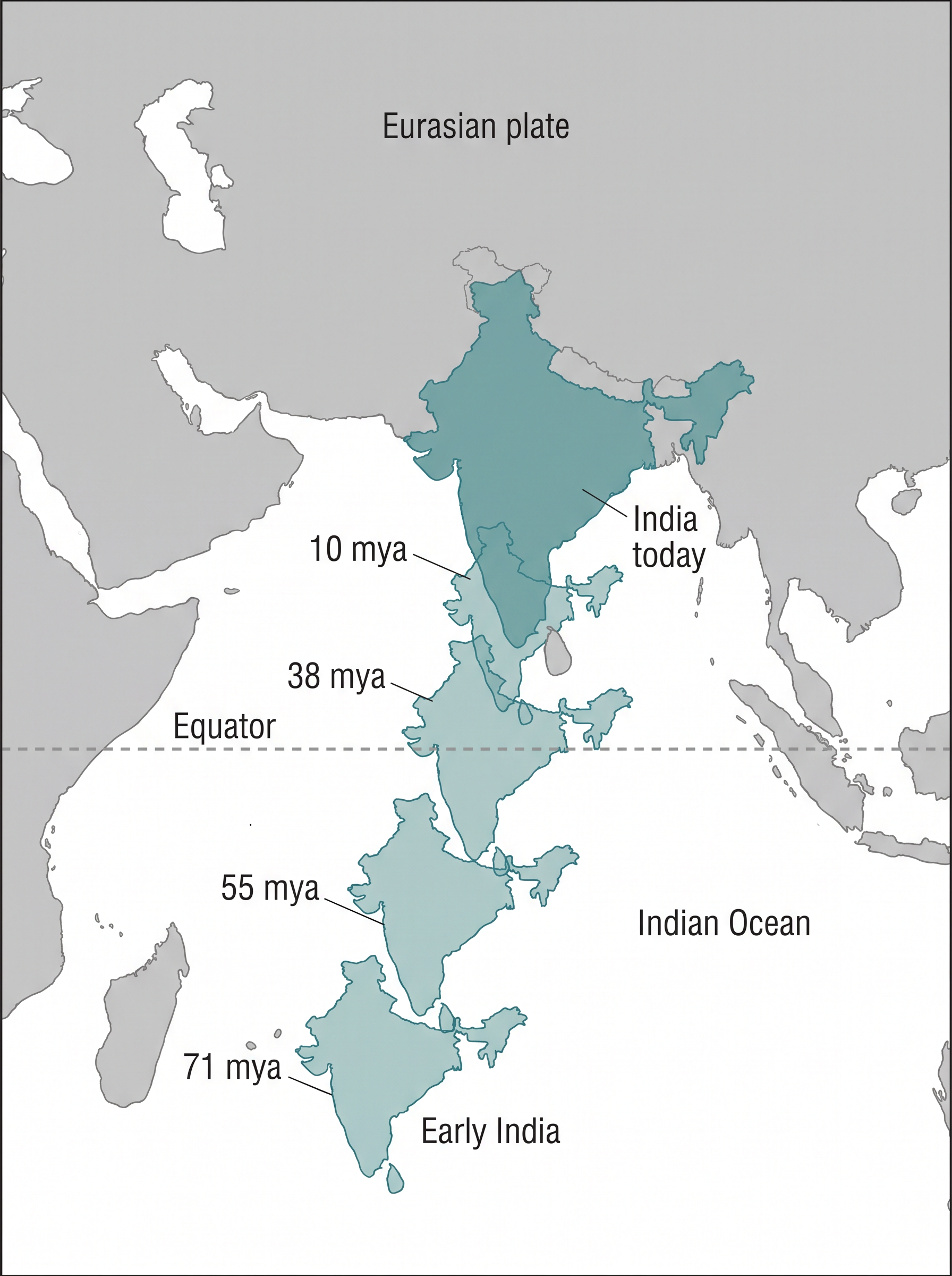
Fig. 4.12 – Movement of the Indian plate.
As the plate carried India north, a huge event unfolded on the moving land itself: the outpouring of lava that built the Deccan Traps, the great layered flood-basalt flows of Peninsular India. This eruption began around 60 million years ago and continued for a long time, while the subcontinent was still close to the equator.
Then came the crash. India collided with Asia about 40 to 50 million years ago, and the impact drove up the Himalayas in a rapid uplift. From about 40 million years ago onward, the mountains rose. The process has never fully stopped: India is still pushing north, and the height of the Himalayas is rising to this day.
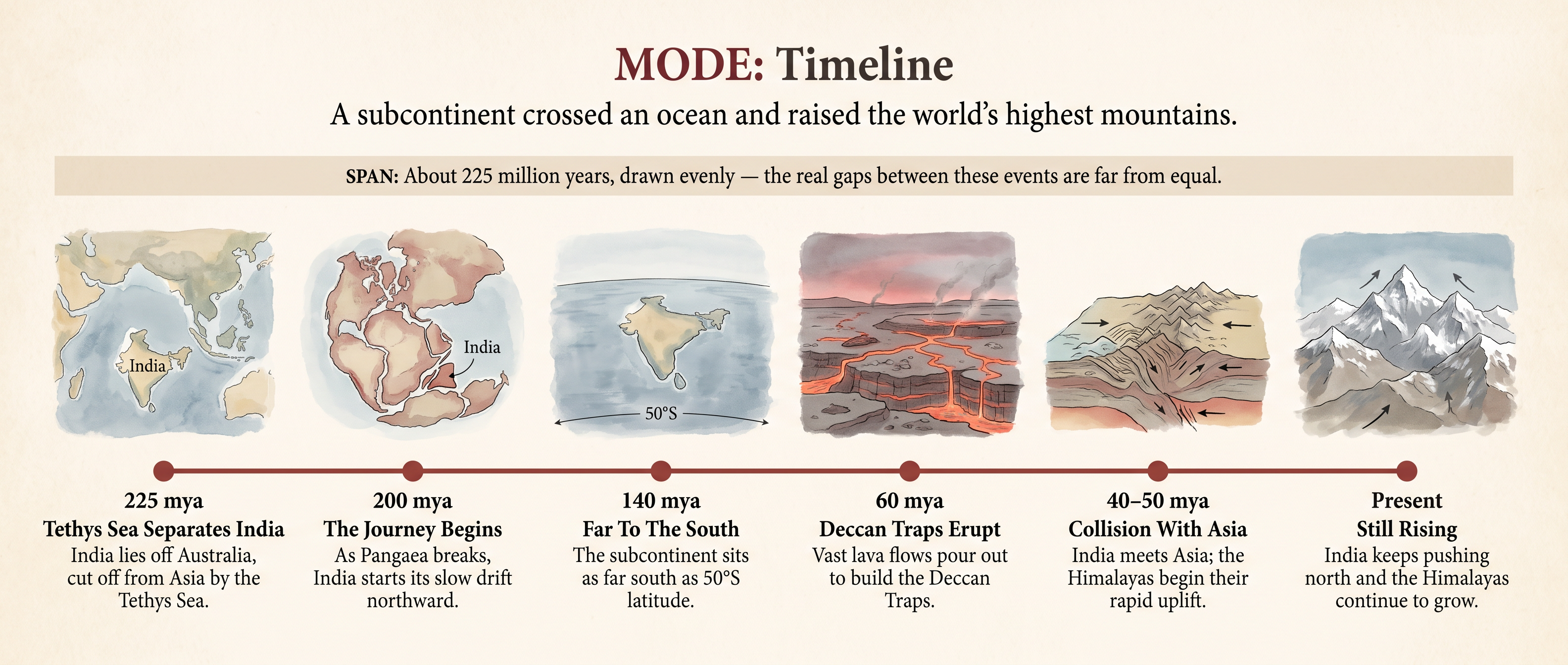
Fig. 4.13 – India’s Northward Journey.
4.8 Summary
- The continents and oceans have not always occupied their present positions, and they will not stay fixed in the future; continents cover 29 per cent of the earth’s surface and water covers the rest.
- Alfred Wegener’s continental drift theory of 1912 proposed that all continents once formed a single supercontinent, Pangaea, ringed by a mega-ocean, Panthalassa, which began to split about 200 million years ago into Laurasia in the north and Gondwanaland in the south, and then into today’s continents.
- Drift was supported by several independent matches across the oceans: the jig-saw fit of facing coastlines, rock belts of the same age, glacial tillite, transported gold placer deposits, and the shared distribution of fossils such as Mesosaurus.
- The theory stalled because the forces Wegener suggested — the pole-fleeing force and the tidal force — were judged far too weak to move continents.
- Post-drift studies supplied what was missing: Arthur Holmes proposed convection currents in the mantle as a possible force, and post-war mapping opened up the ocean floor.
- The ocean floor has three divisions — the continental margins, the deep-sea basins with their level abyssal plains, and the mid-oceanic ridges, the longest mountain chain on earth.
- Earthquakes and volcanoes are not scattered evenly but cluster in belts: a shallow-focus line along the mid-oceanic ridges, and a deep-focus belt along the Alpine-Himalayan system and the Pacific rim, the ring of fire.
- Evidence from the ocean floor — young, symmetrical rocks, thin sediment and matching magnetic properties — led Hess in 1961 to the idea of sea floor spreading: new crust is created at the ridges and consumed at the trenches, so the floor is never older than about 200 million years.
- Plate tectonics, framed in 1967, unified these ideas: the rigid lithosphere is broken into seven major and several minor plates that move over the soft asthenosphere, and it is the plate that moves, carrying the continent as a passenger.
- Plates meet at three kinds of boundary — divergent, where new crust is created; convergent, where crust is destroyed at a subduction zone; and transform, where crust is neither made nor destroyed.
- Plate speeds vary, from less than 2.5 cm per year at the Arctic Ridge to more than 15 cm per year at the East Pacific Rise, and are read from the magnetic strips beside the ridges.
- The driving force is the slow convection of hot, softened mantle beneath the plates, powered by radioactive decay and residual heat.
- The Indian plate carries Peninsular India; India drifted north from off the Australian coast, erupted the Deccan Traps on the way, collided with Asia about 40 to 50 million years ago, and raised the Himalayas, which are still rising today.
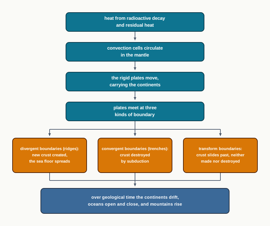
Fig. 4.14 – Summary of plate tectonics.
What This Chapter Cannot Tell You
The dates here run in millions of years and come from rock dating and reconstructions; they are broad estimates, not exact years — the collision with Asia is placed within a 40-to-50-million-year window, not a fixed moment. The maps and figures show average plate positions and boundaries, but they cannot show the motion going on right now, which is only centimetres a year, nor forecast the next earthquake. And the chapter gives the mechanism only in outline: the detailed relief of the ocean floor and the landforms thrown up by colliding plates are left for later chapters.
4.9 NCERT Questions
Who amongst the following was the first to consider the possibility of Europe, Africa and America having been located side by side?
- Alfred Wegener
- Antonio Pellegrini
- Abraham Ortelius
- Edmond Hess
Polar fleeing force relates to:
- Revolution of the Earth
- Gravitation
- Rotation of the earth
- Tides
Which one of the following is not a minor plate?
- Nazca
- Arabia
- Philippines
- Antarctica
Which one of the following facts was not considered by those while discussing the concept of sea floor spreading?
- Volcanic activity along the mid-oceanic ridges.
- Stripes of normal and reverse magnetic field observed in rocks of ocean floor.
- Distribution of fossils in different continents.
- Age of rocks from the ocean floor.
Which one of the following is the type of plate boundary of the Indian plate along the Himalayan mountains?
- Ocean-continent convergence
- Divergent boundary
- Transform boundary
- Continent-continent convergence
What were the forces suggested by Wegener for the movement of the continents? (30 words)
How are the convectional currents in the mantle initiated and maintained? (30 words)
What is the major difference between the transform boundary and the convergent or divergent boundaries of plates? (30 words)
What was the location of the Indian landmass during the formation of the Deccan Traps? (30 words)
What are the evidences in support of the continental drift theory? (150 words)
Bring about the basic difference between the drift theory and Plate tectonics. (150 words)
What were the major post-drift discoveries that rejuvenated the interest of scientists in the study of distribution of oceans and continents? (150 words)
4.10 Check Your Concepts
Using Fig. 4.8, name the type of plate boundary that runs along the Mid-Atlantic Ridge, and state what is happening to the crust there.
From Fig. 4.5, describe how the position of the shallow-focus earthquake belt differs from the position of the deep-focus earthquake belt.
The chapter states that oceanic crust is nowhere older than 200 million years, while some continental rock is as old as 3,200 million years. Using only these figures, work out how many times older the oldest continental rock can be than the oldest oceanic crust.
The East Pacific Rise spreads at more than 15 cm per year. Using this figure, estimate the least width of new ocean floor added over one million years, and give your answer in kilometres. Show your working.
Arrange in the correct order the stages by which the ocean floor is created at a mid-oceanic ridge and finally destroyed at a trench.
Explain why the Himalayas rose along the line where the Indian and Eurasian plates met, rather than anywhere else.
Fig. 4.5 maps earthquakes that have already occurred. Give one reason why this map, on its own, cannot tell you where or when the next earthquake will strike.