Chapter 6: Landforms And Their Evolution
The first heavy shower of the monsoon falls on a bare hill slope. For a few minutes nothing seems to happen. Then the soil can hold no more, and a thin sheet of water begins to slide down the whole surface at once, carrying loose grains with it. Where the ground dips slightly, the sheet gathers into threads. The threads scratch shallow grooves, and the grooves guide the next shower into the same lines.
Come back after one wet season and those grooves are ankle-deep channels. Come back after ten and a few of them have widened into gullies you must jump across. Come back after a thousand and the gullies have joined, deepened and lengthened into a branching network of valleys, with a stream at the bottom of each. The hill has not been struck by anything dramatic. It has simply been touched, over and over, by moving water, and each touch removed a little material and left the slope slightly changed.
Almost every landform on the earth’s surface has a history like this one. Ice, wind and waves work as patiently as running water, and each leaves behind shapes that record exactly how it worked. Learn to read those shapes, and a valley, a cave or a sand dune stops being scenery. It becomes evidence of a process still going on.
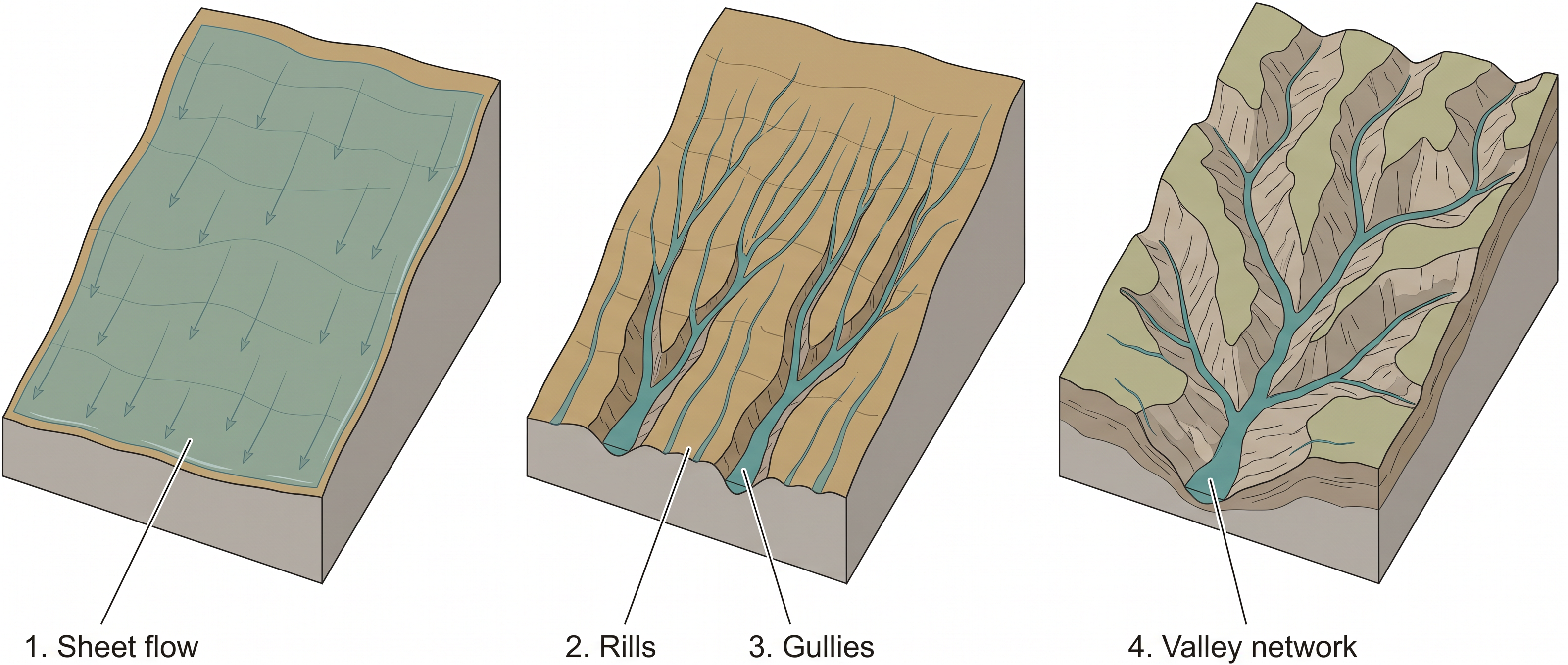
Fig. 6.0 – Evolution of a valley network.
This chapter will let you answer every one of these, not by naming the landform, but by explaining the process that made it.
6.1 Landforms And Landscapes
From Weathering To Landforms
Weathering is the breaking down of rock where it stands, with no movement of the broken material. It leaves behind a loose cover of shattered and chemically altered rock, but it does not carry that cover anywhere. Something else must do the carrying.
That work is done by the geomorphic agents — running water, groundwater, wind, glaciers and waves. An agent is a moving medium that can pick up loosened material, take it away and drop it somewhere else. Each of these five agents is given a section of its own later in this chapter.
Their first job is erosion, the removal of earth material by a moving agent. You already know that erosion changes the surface of the earth. What is easy to forget is that the removed material does not vanish. It travels, and wherever the agent slows down and can no longer carry it, the material is put down again.
That putting down is deposition, and it follows erosion everywhere. Deposition changes the surface just as surely as erosion does. A slope loses material and gets lower; a plain below it gains material and gets higher. Both are changes, and both make landforms.
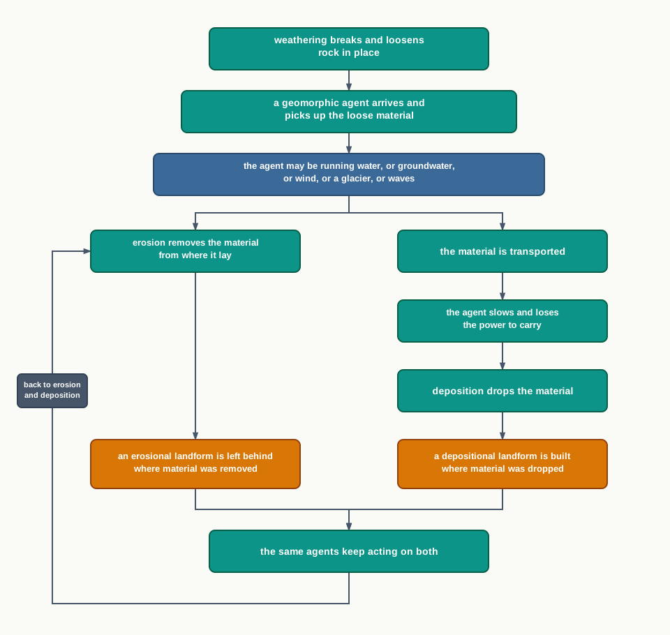
Fig. 6.1 – Weathering, erosion and deposition.
What Is A Landform?
Since this chapter is about landforms and their evolution, start with the plainest question of all. What is a landform?
In simple words, small to medium tracts or parcels of the earth’s surface are called landforms. A gully cut into a field, a sand dune, a cliff at the sea’s edge, a fan of gravel at the foot of a hill — each of these is one parcel of the surface with a shape of its own.
Several related landforms together make up a landscape, which is a large tract of the earth’s surface. The word ‘related’ is doing real work in that sentence. The landforms in a landscape are related because the same agent, working in the same conditions, made all of them.
Each landform has its own physical shape, its own size and its own materials, and it is the result of the action of certain geomorphic processes and agents. The actions of most geomorphic processes and agents are slow, and so the results take a long time to take shape. But every landform has a beginning.
Landforms Change, And That Change Is Evolution
Once formed, a landform does not stay fixed. It may change in shape, in size and in nature, slowly or fast, because the geomorphic processes and agents that made it are still acting on it.
Two things can shift the conditions under which those processes work. One is a change in climate — an area that was humid may turn dry, and the agent that dominates it will change with it. The other is vertical or horizontal movement of landmasses, which raises or lowers the land and so alters the slope every agent has to work on. When either happens, the intensity of a process may change, or the process itself may be replaced by a different one, and the landform is modified along new lines.
Evolution here means the stages of transformation of either a part of the earth’s surface from one landform into another, or the transformation of individual landforms after they are once formed. Both senses matter. A slope may stop being a gully and become a valley; and a valley, once it exists, goes on being changed.
That means each and every landform has a history of development and of change through time. A landmass passes through stages of development that are somewhat comparable to the stages of a life — youth, mature and old age. These three stages are described in detail in the next section, for a landscape being shaped by running water.
6.2 Running Water
In humid regions, which receive heavy rainfall, running water is considered the most important of the geomorphic agents in bringing about the degradation of the land surface. Water is abundant there, it falls often, and it is always pulled downslope. Nothing else works on so much of the land, so much of the time.
Two Ways Water Moves
Running water has two components, and they do quite different work. One is overland flow, in which water moves across the general land surface as a sheet, without any channel to hold it. The other is linear flow, in which water is gathered into streams and rivers that run in valleys of their own making.
Most of the erosional landforms made by running water are associated with vigorous and youthful rivers flowing over steep gradients. A steep gradient means a fast current, and a fast current has the energy to cut. With time, stream channels over steep gradients turn gentler because of continued erosion, and as a consequence they lose their velocity. Losing velocity is what makes active deposition possible.
There may be depositional forms associated with streams flowing over steep slopes as well. But these will be on a small scale compared to those associated with rivers flowing over medium to gentle slopes. The rule is simple and worth holding on to: the gentler the river channel in gradient or slope, the greater is the deposition.
When the stream bed turns gentler because of continued erosion, downward cutting becomes less dominant and lateral erosion of the banks increases. The river stops deepening and starts widening. As a consequence, over long spans of time, hills and valleys are reduced to plains.
From Rills To Valleys
Overland flow causes sheet erosion, the removal of a thin layer of material from the whole surface at once. Depending upon irregularities of the land surface, the overland flow may concentrate into narrow to wide paths. Water always finds the low line.
Because of the sheer friction of the column of flowing water, minor or major quantities of material are removed from the surface of the land in the direction of flow. Gradually, small and narrow rills will form. These rills will develop into long and wide gullies; the gullies will further deepen, widen, lengthen and unite to give rise to a network of valleys.
This network does not stay the same. In the early stages, down-cutting dominates, and during it irregularities such as waterfalls and cascades are removed — the river is levelling out the steps in its own bed. In the middle stages, streams cut their beds more slowly, and lateral erosion of the valley sides becomes severe. Gradually, the valley sides are reduced to lower and lower slopes.
Meanwhile the divides are lowered too. A divide is the high ground separating one drainage basin, the area drained by a river and its tributaries, from the next. The divides between drainage basins are worn down until they are almost completely flattened, leaving finally a lowland of faint relief with some low resistant remnants called monadnocks standing out here and there. This type of plain, formed as a result of stream erosion, is called a peneplain, which means an almost plain.
The characteristics of each of the stages of landscapes developing in running water regimes may be summarised as follows.
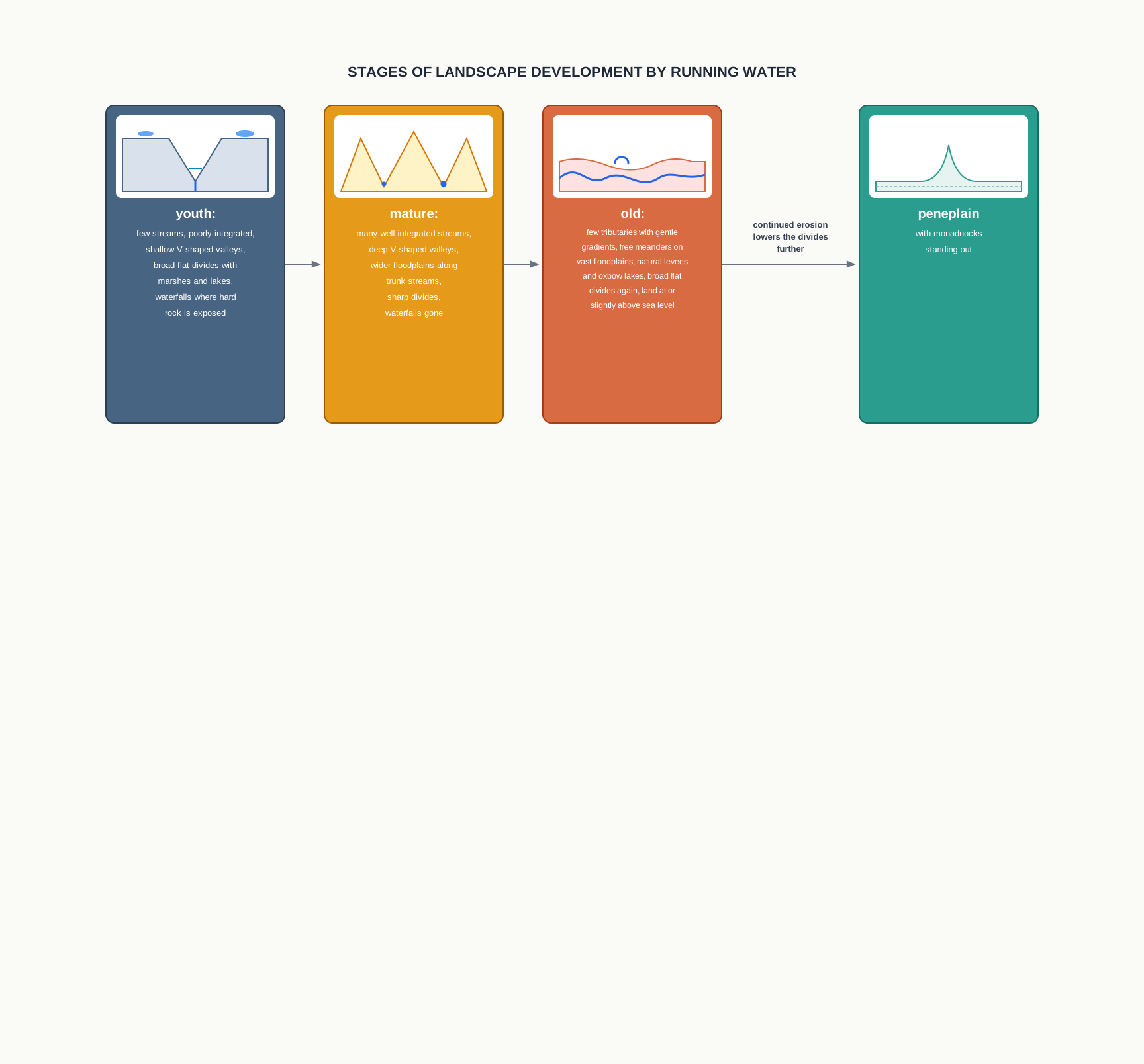
Fig. 6.2 – Stages of landscape development in running water.
6.2.1 Youth
Streams are few during this stage, with poor integration, meaning they have not yet joined into a well-connected network. They flow over the original slopes of the land, showing shallow V-shaped valleys with no floodplains, or with very narrow floodplains along the trunk streams.
Stream divides are broad and flat, with marshes, swamps and lakes on them. Water still stands on the uplands because no stream has yet cut deep enough to drain them. Meanders, if present, develop over these broad upland surfaces, and such meanders may eventually entrench themselves into the uplands.
Waterfalls and rapids may exist where local hard rock bodies are exposed. These are the irregularities the young river has not yet had time to remove.
6.2.2 Mature
During this stage streams are plenty, with good integration. The whole network now drains the land efficiently. The valleys are still V-shaped but deep, because down-cutting has had a long time to work.
Trunk streams are broad enough to have wider floodplains, within which the streams may flow in meanders confined within the valley. The flat and broad inter-stream areas and the swamps and marshes of youth disappear, and the stream divides turn sharp. Waterfalls and rapids disappear.
6.2.3 Old
Smaller tributaries during old age are few, and they have gentle gradients. Streams meander freely over vast floodplains, showing natural levees, oxbow lakes and similar forms. The river has almost no slope left to cut into, so nearly all its work is lateral.
Divides are broad and flat again, with lakes, swamps and marshes on them — but for the opposite reason to youth. In youth the divides were untouched; in old age they have been worn down almost to nothing. Most of the landscape is at or slightly above sea level.
6.2.4 Erosional Landforms
6.2.4.1 Valleys
Valleys start as small and narrow rills; the rills gradually develop into long and wide gullies; the gullies further deepen, widen and lengthen to give rise to valleys. The same chain that builds a valley network is at work inside every single valley.
Depending upon dimensions and shape, many types of valleys can be recognised — the V-shaped valley, the gorge, the canyon and others. A gorge is a deep valley with very steep to straight sides (Fig. 6.3). A canyon is characterised by steep step-like side slopes (Fig. 6.4), and may be as deep as a gorge.
The difference between the two is a matter of cross-section, and it is worth being exact about. A gorge is almost equal in width at its top as well as at its bottom, so its walls rise nearly vertically. A canyon, in contrast, is wider at its top than at its bottom, so its walls climb away in steps. In fact, a canyon is a variant of gorge.
Why the difference? Valley types depend upon the type and structure of the rocks in which they form. Canyons commonly form in horizontal bedded sedimentary rocks, where each bed resists the river a little differently and the walls retreat bed by bed, leaving steps. Gorges form in hard rocks, which stand up as a single mass and give a wall of nearly constant width.
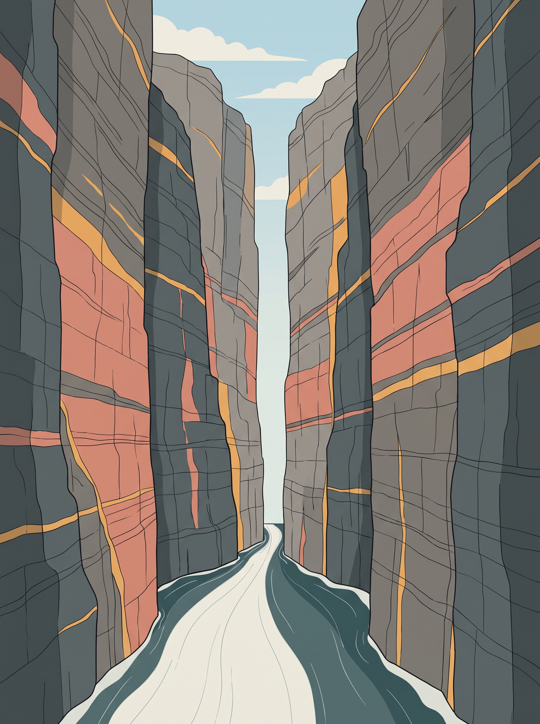
Fig. 6.3 – Gorge on the Kaveri river.
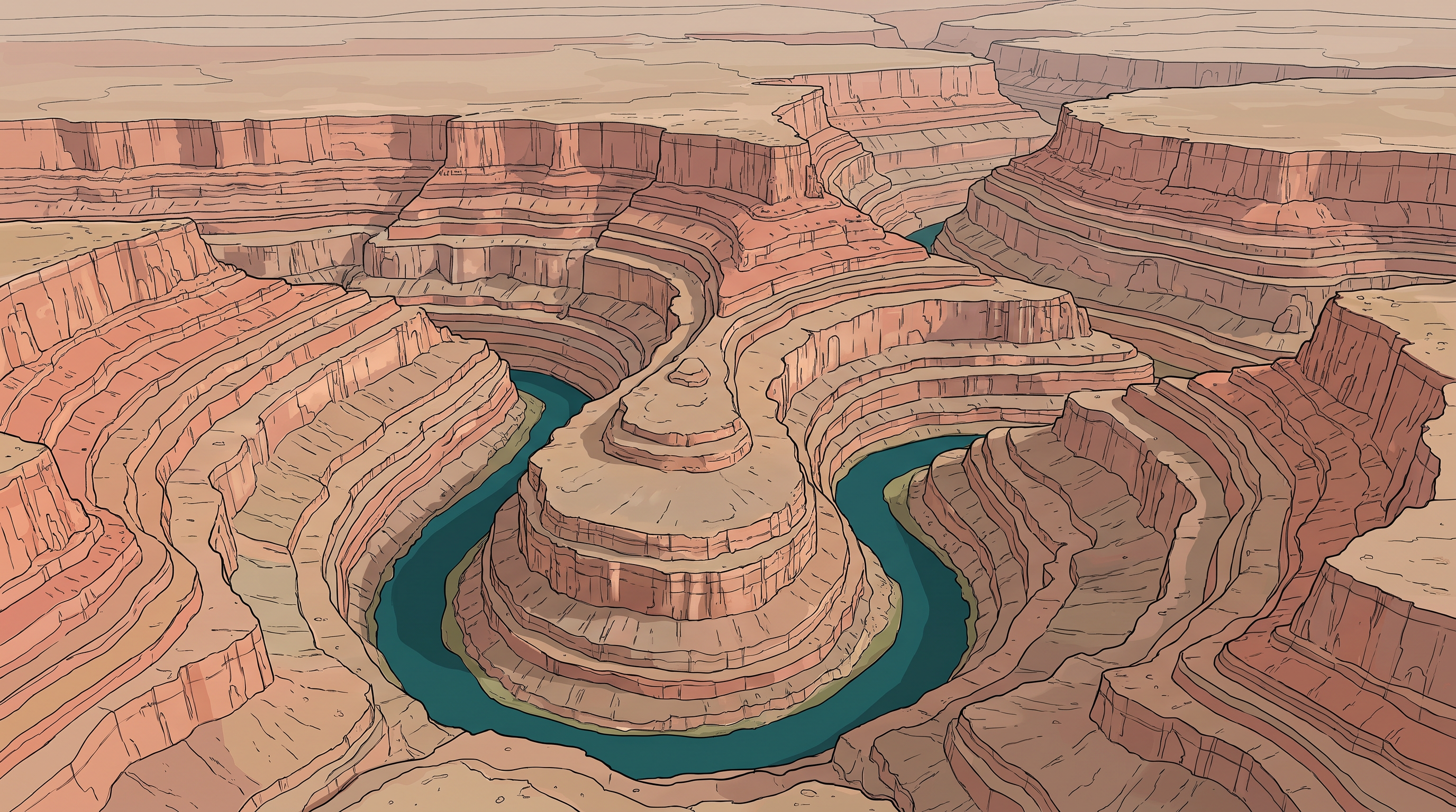
Fig. 6.4 – Entrenched meander loop of the Colorado river.
6.2.4.2 Potholes And Plunge Pools
Over the rocky beds of hill-streams, more or less circular depressions called potholes form because of stream erosion aided by the abrasion of rock fragments. Abrasion is the grinding of the bed by the load the river is carrying — the river cuts with its tools, not with water alone.
Once a small and shallow depression forms, pebbles and boulders get collected in it and get rotated by the flowing water. Spinning stones grind the hollow deeper and wider, so the depression grows in dimensions. A series of such depressions eventually joins together, and in this way the stream valley itself gets deepened.
At the foot of waterfalls also, large potholes form, quite deep and wide. Here the cutting is done by the sheer impact of falling water and the rotation of boulders at the base. Such large and deep holes at the base of waterfalls are called plunge pools.
6.2.4.3 Incised Or Entrenched Meanders
In streams that flow rapidly over steep gradients, erosion is normally concentrated on the bottom of the stream channel. Also, in the case of steep gradient streams, lateral erosion on the sides of the valleys is not much when compared to streams flowing on low and gentle slopes.
Because of active lateral erosion, streams flowing over gentle slopes develop sinuous or meandering courses. It is common to find meandering courses over floodplains and delta plains, where stream gradients are very gentle.
But very deep and wide meanders can also be found cut in hard rocks. Such meanders are called incised or entrenched meanders (Fig. 6.4). They are a puzzle worth holding in mind: a loop is the signature of a slow river on soft alluvium, yet here it is, sunk deep into rock.
6.2.4.4 River Terraces
River terraces are surfaces marking old valley floor or floodplain levels. They may be bedrock surfaces without any alluvial cover, or alluvial terraces consisting of stream deposits — alluvium being the material a river itself has laid down.
River terraces are basically products of erosion, even though some of them are made of deposits. They result from vertical erosion by the stream into its own depositional floodplain: the river builds a floodplain, then cuts down into it and leaves the old surface stranded above the new channel.
There can be a number of such terraces at different heights, each one indicating a former river bed level. The river terraces may occur at the same elevation on either side of the river, in which case they are called paired terraces.
6.2.5 Depositional Landforms
6.2.5.1 Alluvial Fans
Alluvial fans (Fig. 6.5) are formed when streams flowing from higher levels break into foot slope plains of low gradient. Normally, very coarse load — gravel, cobbles, boulders — is carried by streams flowing over mountain slopes, because a steep, fast stream has the energy to move heavy material.
At the foot of the mountain the slope suddenly flattens. That load now becomes too heavy for the stream to be carried over gentler gradients, and it gets dumped and spread as a broad, low to high cone shaped deposit called an alluvial fan. The fan is simply the shape of the pile a stream makes when it drops everything at once at the point where the slope breaks.
Usually, the streams which flow over fans are not confined to their original channels for long. They shift their position across the fan, forming many channels called distributaries — channels that carry water away from a single stream instead of bringing it in.
Climate shapes the profile of the cone. Alluvial fans in humid areas normally show low cones with a gentle slope from head to toe, because water is plentiful and keeps carrying material further out. They appear as high cones with a steep slope in arid and semi-arid climates, where there is not enough water to spread the load far.
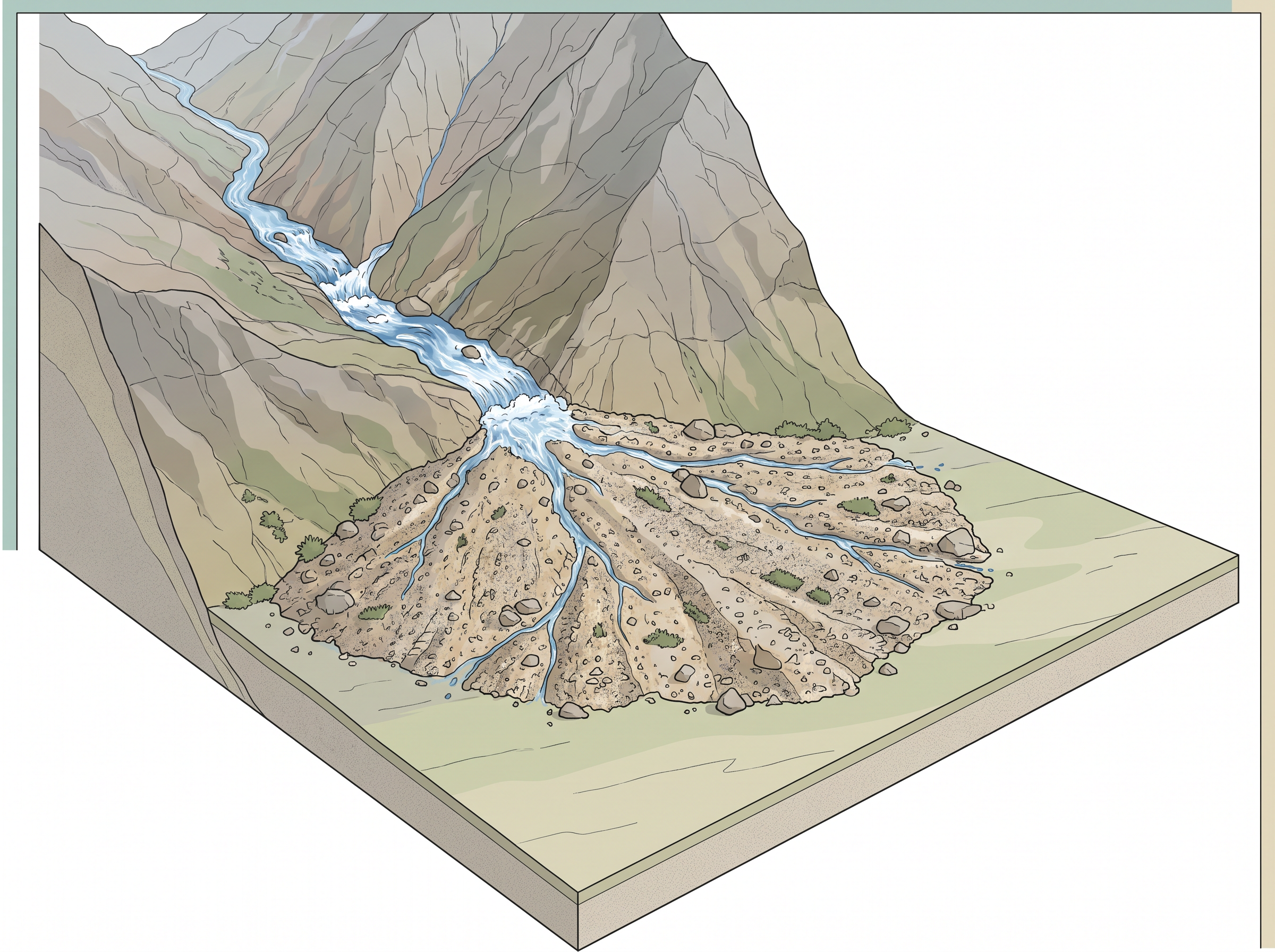
Fig. 6.5 – Alluvial fan in Jammu and Kashmir.
6.2.5.2 Deltas
Deltas are like alluvial fans, but they develop at a different location. The load carried by the rivers is dumped and spread into the sea. If this load is not carried away far into the sea or distributed along the coast by currents, it spreads and accumulates as a low cone.
Unlike in alluvial fans, the deposits making up deltas are very well sorted, with clear stratification — that is, the material is separated by size and laid in distinct layers. The coarsest materials settle out first, near the shore, and the finer fractions like silts and clays are carried out into the sea before they can settle.
As the delta grows, the river distributaries continue to increase in length (Fig. 6.6), and the delta continues to build up into the sea. The river is, in effect, extending the land at the cost of the sea.
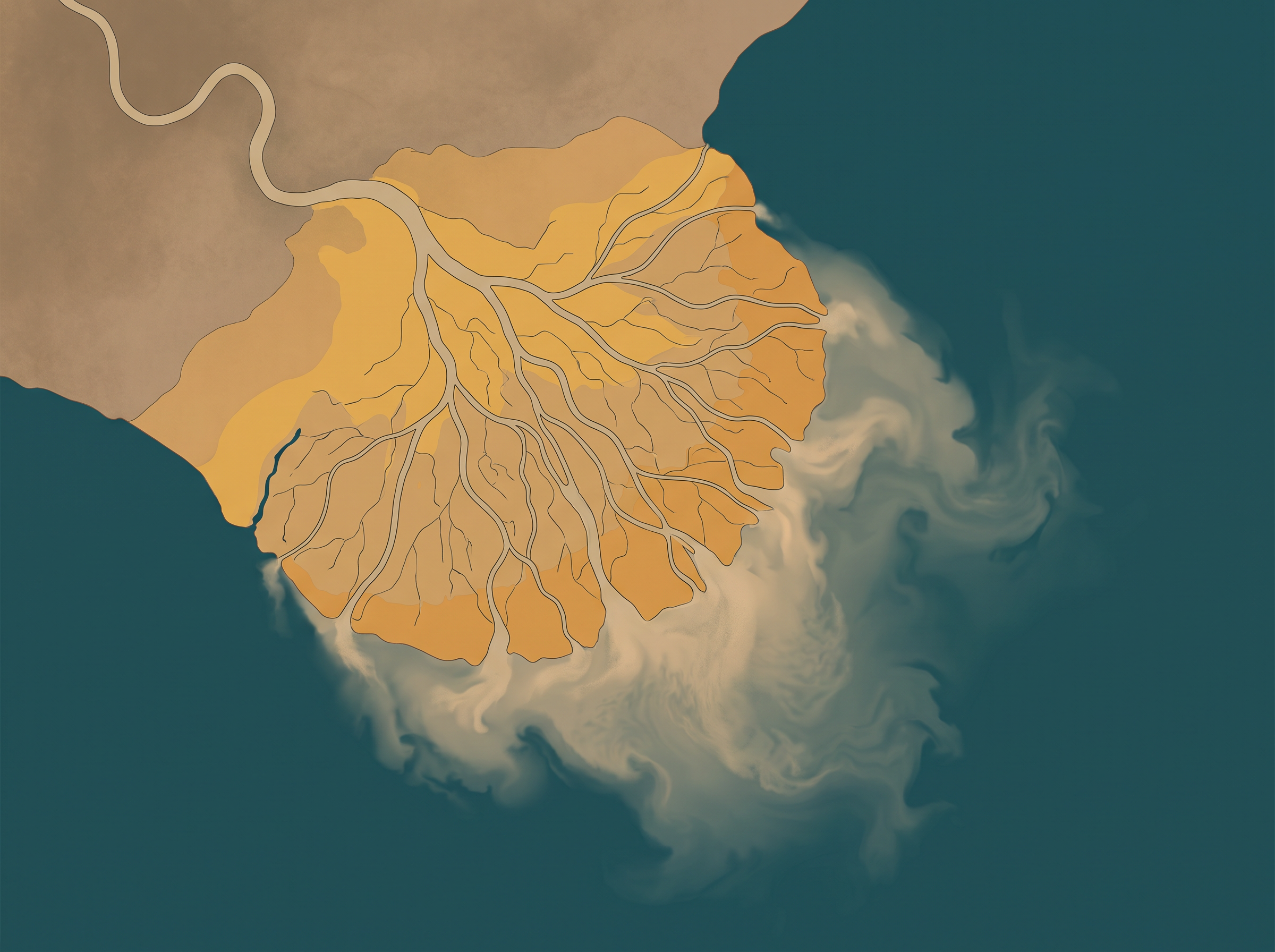
Fig. 6.6 – The Krishna river delta.
6.2.5.3 Floodplains, Natural Levees And Point Bars
Deposition develops a floodplain just as erosion makes valleys. The floodplain is a major landform of river deposition, and it is built in two quite different acts.
Large sized materials are deposited first, when the stream channel breaks into a gentle slope. So, normally, only the fine sized materials — sand, silt and clay — are still being carried by the relatively slow moving waters in the gentler channels usually found in the plains. These fine materials are deposited over the bed, and also when the waters spill over the banks during flooding above the bed.
A river bed made of river deposits is the active floodplain. The floodplain above the bank is the inactive floodplain, reached only when the river is in flood. The inactive floodplain above the banks basically contains two types of deposits — flood deposits and channel deposits.
The two are made in different ways, and they are made of different stuff. In plains, channels shift laterally and change their courses occasionally, leaving cut-off courses which get filled up gradually. Such areas over floodplains, built up by abandoned or cut-off channels, contain coarse deposits, because a channel carries coarse material. The flood deposits of spilled waters, in contrast, carry relatively finer materials like silt and clay, because water that has left the channel is slow. The flood plains in a delta are called delta plains.
Natural levees and point bars (Fig. 6.7) are some of the important landforms found associated with floodplains. Natural levees are found along the banks of large rivers. They are low, linear and parallel ridges of coarse deposits along the banks of rivers, quite often cut into individual mounds. They form because water leaving the channel in flood slows abruptly at the bank and drops its coarsest load right there.
Point bars are also known as meander bars. They are found on the concave side of meanders of large rivers, and are sediments deposited in a linear fashion by flowing waters along the bank. They are almost uniform in profile and in width, and contain mixed sizes of sediments.
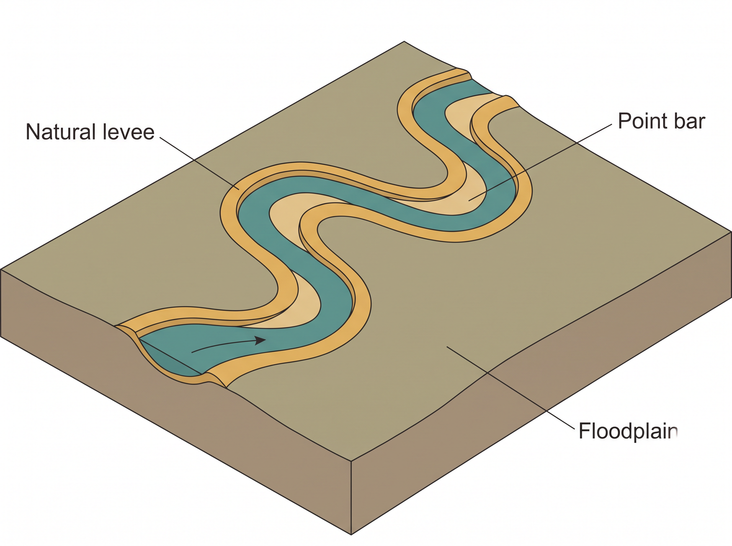
Fig. 6.7 – Natural levee and point bars.
6.2.5.4 Meanders
In large flood and delta plains, rivers rarely flow in straight courses. Loop-like channel patterns called meanders develop over flood and delta plains (Fig. 6.8).
A meander is not a landform but is only a type of channel pattern. That distinction matters. A landform is a parcel of the surface with a shape; a meander is the shape of the river’s path across it.
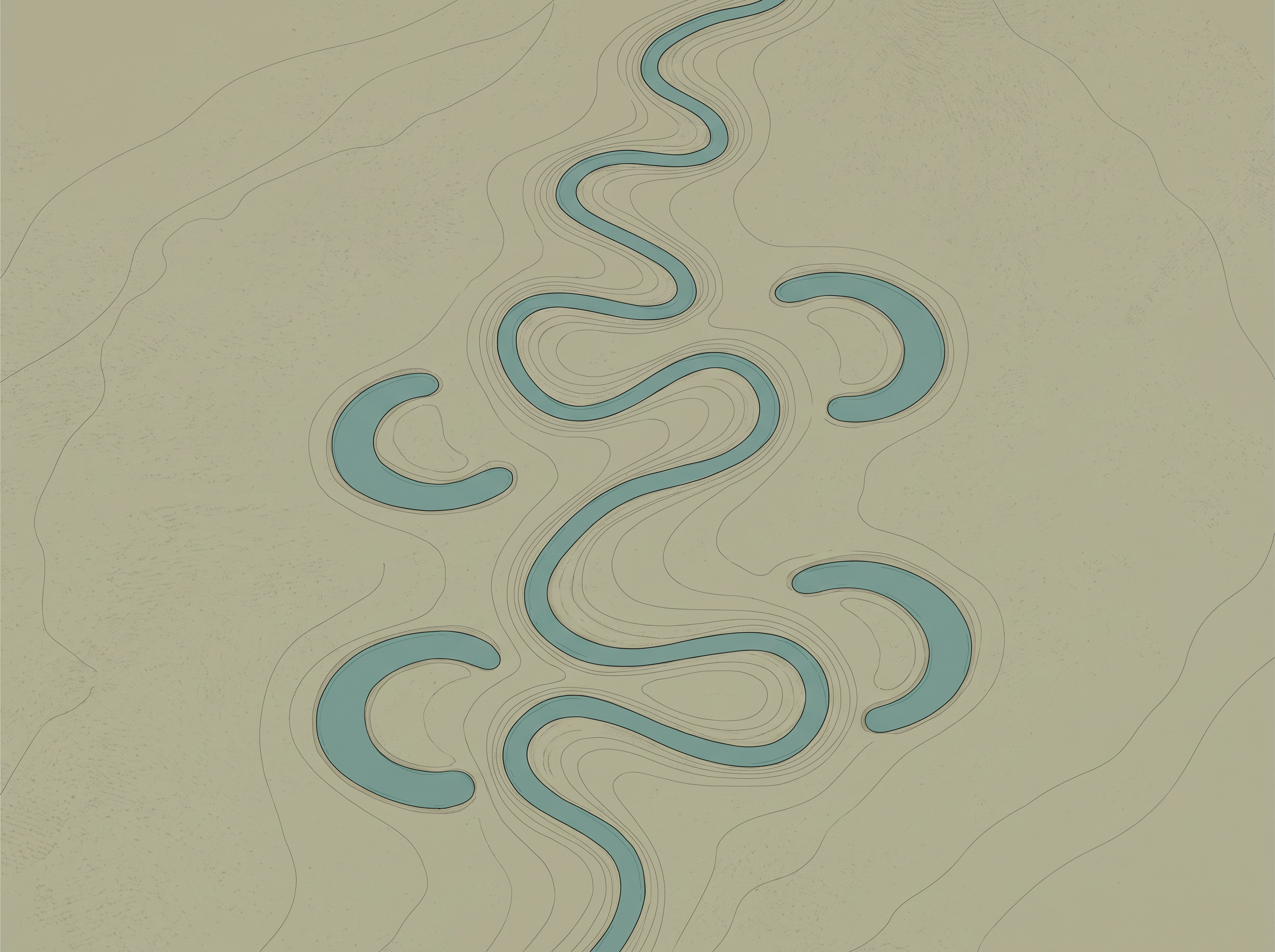
Fig. 6.8 – Meandering Burhi Gandak river and ox-bow lakes.
Three conditions make meandering possible, and all three belong to a plain rather than a hill. First, water flowing over very gentle gradients has a propensity to work laterally on the banks, because it has little downward cutting left to do. Second, the alluvial deposits making up the banks are unconsolidated — loose, unbound material with many irregularities in it, which water can exploit by exerting pressure sideways. Third, the coriolis force, the deflection acting on any fluid moving over the rotating earth, acts on the flowing water and deflects it, just as it deflects the wind.
When the gradient of the channel becomes extremely low, water flows leisurely and starts working laterally. Slight irregularities along the banks slowly get transformed into a small curvature in the banks.
Once a curve exists, it feeds itself. The curvature deepens due to deposition on the inside of the curve and erosion along the bank on the outside. If there is no deposition and no erosion or undercutting, the tendency to meander is reduced — both halves of the process are needed.
Normally, in meanders of large rivers, there is active deposition along the convex bank and undercutting along the concave bank. The concave bank is known as the cut-off bank, which shows up as a steep scarp, and the convex bank presents a long, gentle profile (Fig. 6.9).
As meanders grow into deep loops, the same may get cut off due to erosion at the inflection points — the places where the channel changes from bending one way to bending the other. The river takes the short path across the neck, abandons the loop, and the loop is left as an ox-bow lake, a crescent of standing water on the floodplain.
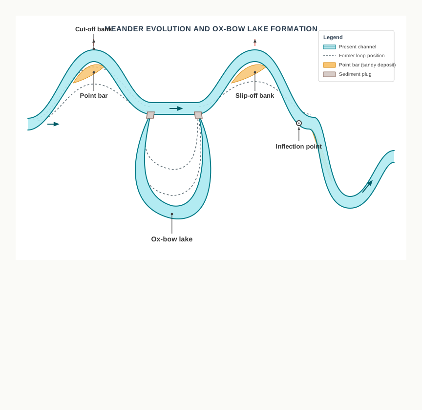
Fig. 6.9 – Meander growth and cut-off.
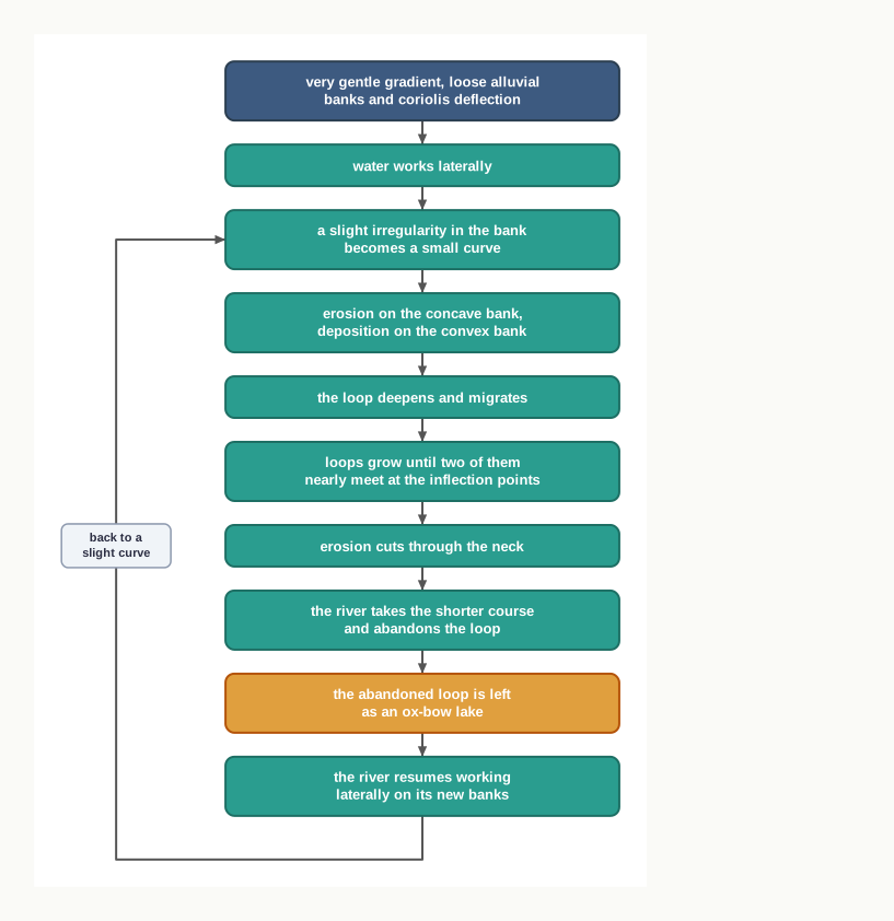
Fig. 6.10 – Formation of an ox-bow lake.
6.3 Groundwater
Here the interest is not on groundwater as a resource. Our focus is on the work of groundwater in the erosion of landmasses and the evolution of landforms — water as a cutting agent, not water as a supply.
How Water Gets Below The Surface
Surface water percolates well when the rocks are permeable, thinly bedded, and highly jointed and cracked. A permeable rock is one that will let water pass through it; joints are the cracks along which a rock has split, and bedding planes are the surfaces separating one layer of a sedimentary rock from the next. Water uses all of them as roads.
After vertically going down to some depth, the water under the ground begins to flow horizontally, through the bedding planes, through the joints, or through the materials themselves. It is this downward and then horizontal movement of water which causes the rocks to erode.
But groundwater does not erode the way a river does. Physical or mechanical removal of material by moving groundwater is insignificant in developing landforms — underground water moves too slowly and carries no tools. That is why the results of the work of groundwater cannot be seen in all types of rocks.
Where Groundwater Can Work
There is one family of rocks in which groundwater becomes a powerful agent. In rocks like limestones or dolomites, which are rich in calcium carbonate, the surface water as well as the groundwater develops a variety of landforms through the chemical process of solution and through precipitation deposition.
Solution is the dissolving of the rock into the water itself; precipitation deposition is the opposite act, in which the dissolved material comes back out of the water as solid rock. These two processes are active in limestones or dolomites occurring either exclusively or interbedded with other rocks — that is, sandwiched in layers between rocks of other kinds.
Any limestone or dolomitic region showing typical landforms produced by the action of groundwater through the processes of solution and deposition is called Karst topography. It is named after the typical topography developed in the limestone rocks of the Karst region in the Balkans, in south-eastern Europe, adjacent to the Adriatic sea.
The karst topography is also characterised by erosional and depositional landforms — the same twin signature that running water leaves, made here by chemistry instead of by force.
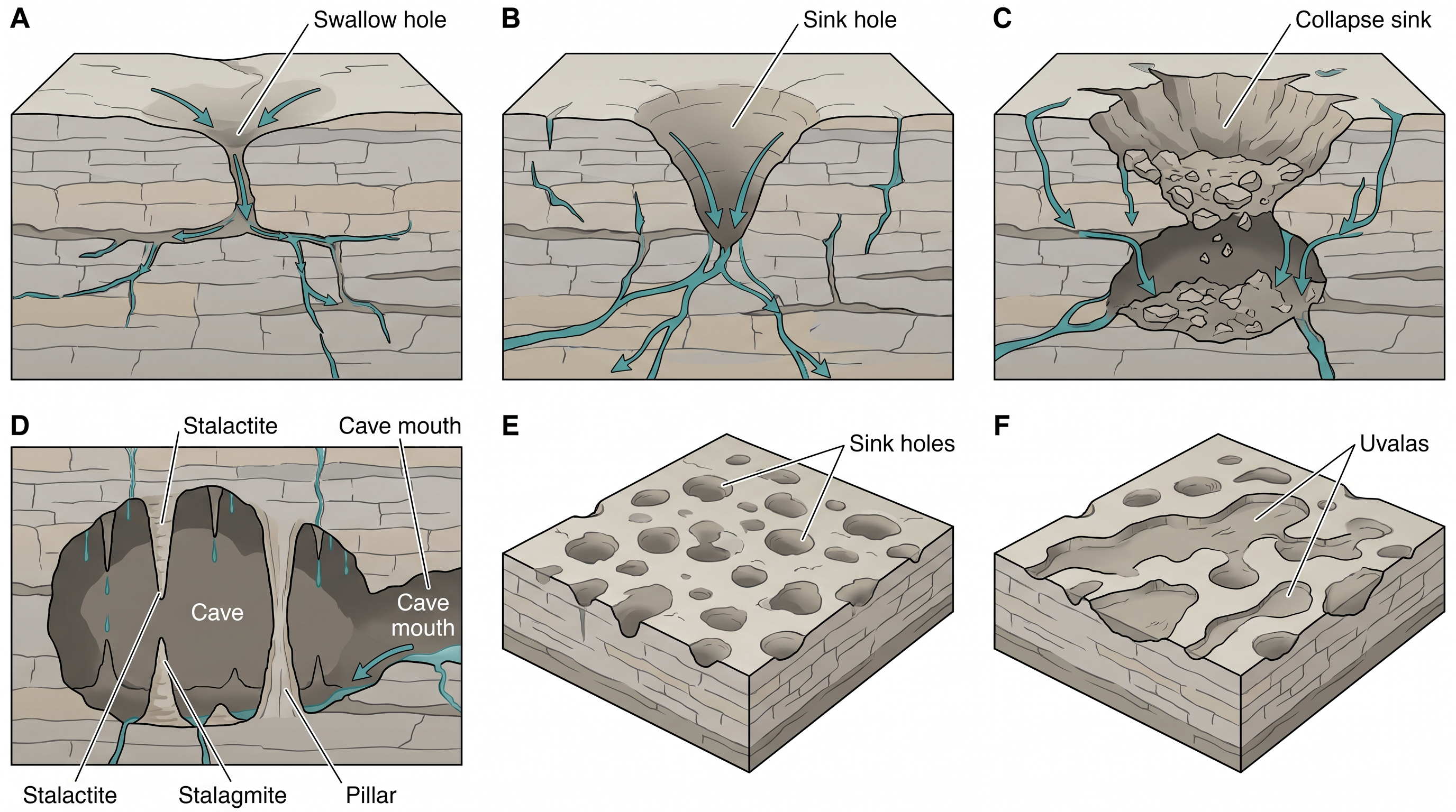
Fig. 6.11 – Karst topography features.
6.3.1 Erosional Landforms
6.3.1.1 Pools, Sinkholes, Lapies And Limestone Pavements
Small to medium sized, round to sub-rounded shallow depressions called swallow holes form on the surface of limestones through solution. They are the first mark that water is getting in.
Sinkholes are very common in limestone or karst areas. A sinkhole is an opening more or less circular at the top and funnel-shaped towards the bottom. Their sizes vary in area from a few sq. m to a hectare — a hectare being 10,000 square metres — and in depth from less than half a metre to thirty metres or more.
Sinkholes are made in two different ways, and the difference is worth holding. Some form solely through solution action, and these are called solution sinks: the rock is simply eaten away from the surface downwards. Others might start as solution forms first, and then, if the bottom of a sinkhole forms the roof of a void or cave underground, that roof might collapse, leaving a large hole opening into the cave or void below. These are collapse sinks, and the term doline is sometimes used to refer to them. Solution sinks are more common than collapse sinks.
Quite often, sinkholes are covered up with a soil mantle and appear as shallow water pools. They look like harmless puddles in a field. Anybody stepping over such a pool would go down through it, as happens in the quicksands of deserts.
Quite often the surface run-off simply goes down swallow and sink holes, flows as an underground stream, and re-emerges at a distance downstream through a cave opening. In limestone country a river can disappear from the map for a while and come back.
When sink holes and dolines join together — because of slumping of material along their margins, or because of the roof collapse of caves beneath them — long, narrow to wide trenches called valley sinks or Uvalas form. Several separate holes become one connected trench.
Gradually, most of the surface of the limestone is eaten away by these pits and trenches, leaving it extremely irregular, with a maze of points, grooves and ridges called lapies. These ridges form due to differential solution activity along parallel to sub-parallel joints — solution works fastest along the cracks, so the rock between the cracks is left standing as a ridge.
The lapie field may eventually turn into somewhat smooth limestone pavements, when solution has worn the sharp points down.
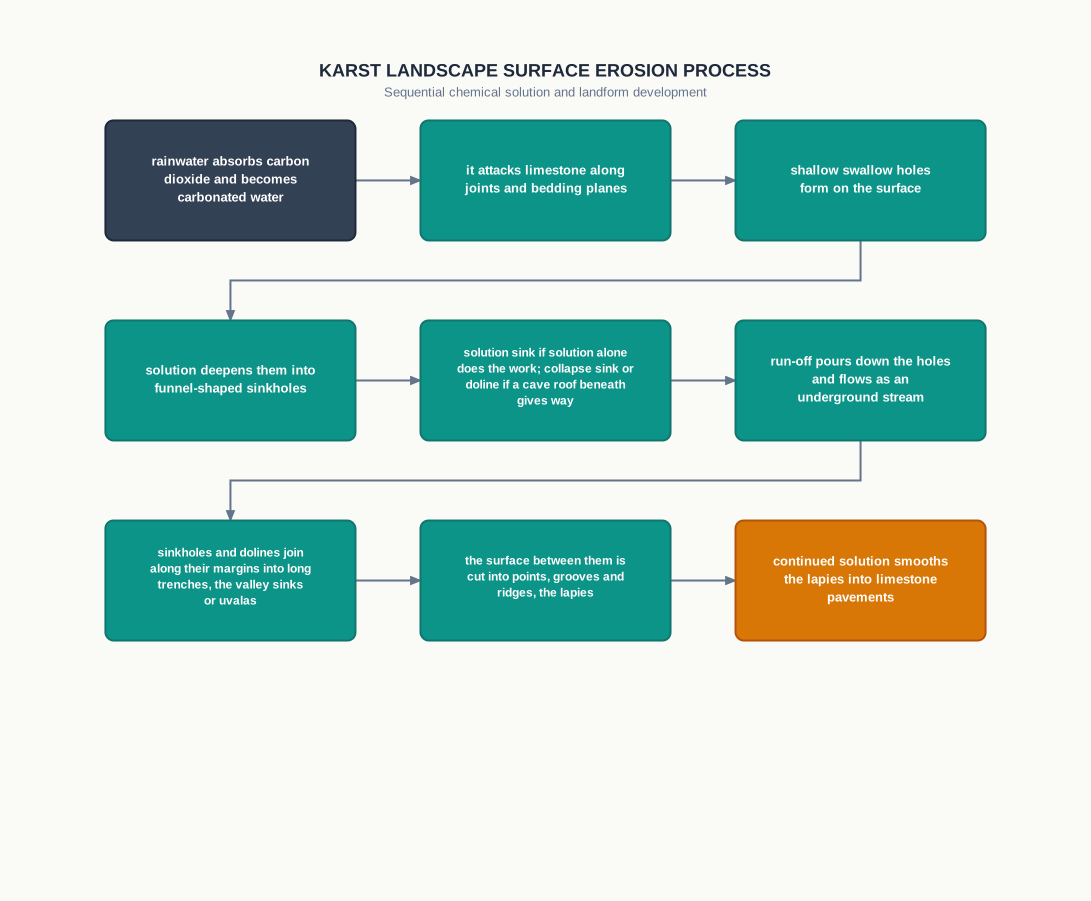
Fig. 6.12 – Evolution of karst topography.
6.3.1.2 Caves
Cave formation is prominent in two settings. The first is where there are alternating beds of rocks — shales, sandstones, quartzites — with limestones or dolomites in between them. The second is where limestones are dense, massive, and occur as thick beds.
Water percolates down either through the materials themselves or through cracks and joints, and then moves horizontally along the bedding planes. It is along these bedding planes that the limestone dissolves, and long and narrow to wide gaps called caves result. The cave takes the shape of the road the water took.
There can be a maze of caves at different elevations, depending upon where the limestone beds lie and what rocks lie between them. Caves normally have an opening through which cave streams are discharged, and caves having openings at both the ends are called tunnels.
6.3.2 Depositional Landforms
Many depositional forms develop within the limestone caves. They are built from exactly the material that solution took away, which is why groundwater’s two processes belong together.
The chief chemical in limestone is calcium carbonate, which is easily soluble in carbonated water — that is, in rainwater that has absorbed carbon dioxide from the air. Carbonated water can hold calcium carbonate in solution, but only so long as it keeps its carbon dioxide.
So the calcium carbonate is deposited again in two situations: when the water carrying it in solution evaporates, or when it loses its carbon dioxide as it trickles over rough rock surfaces. A rough surface releases the gas from the water, and the moment the gas goes, the rock comes out.
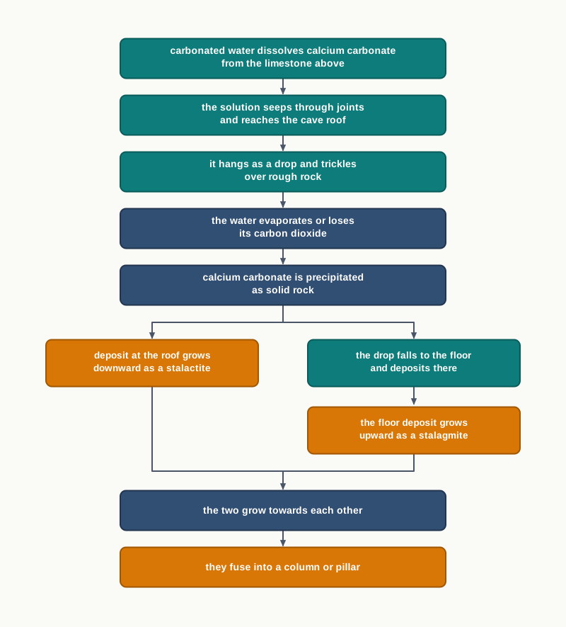
Fig. 6.13 – Formation of stalactites, stalagmites and pillars.
6.3.2.1 Stalactites, Stalagmites And Pillars
Stalactites hang as icicles of different diameters from the roofs of caves. Normally they are broad at their bases, where they are attached to the rock, and taper towards their free ends, showing up in a variety of forms.
Stalagmites rise up from the floor of the caves. They form directly because of the dripping water — water dripping from the cave surface, or water that has run down through the thin pipe of a stalactite and fallen from its tip, immediately below it (Fig. 6.14). A stalagmite is, in that sense, the record of where the drops landed.
Stalagmites may take the shape of a column or a disc, with either a smooth, rounded bulging end or a miniature crater-like depression at the top. The shape depends on how the drop lands and spreads.
The stalagmite and the stalactite eventually fuse, growing towards each other until they meet, and give rise to columns and pillars of different diameters. A pillar is a completed connection between the roof and the floor of a cave, made entirely of rock that arrived one drop at a time.
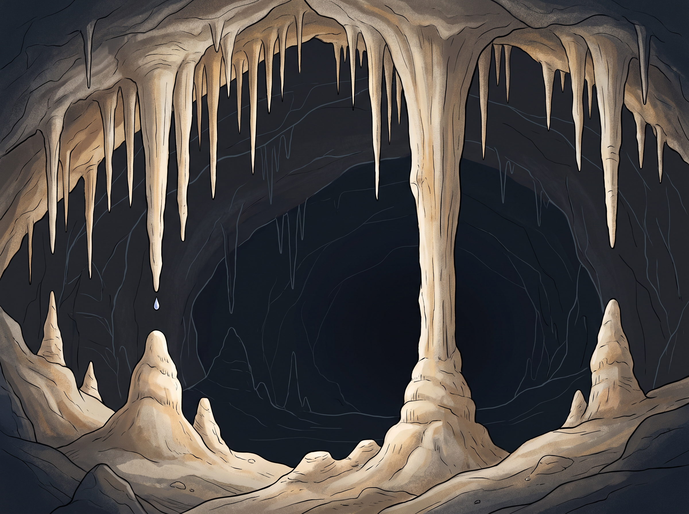
Fig. 6.14 – Stalactites and stalagmites in limestone caves.
6.4 Glaciers
Masses of ice moving over the land are called glaciers (Fig. 6.15). They come in two broad forms. Some move as sheets over the land — a continental glacier, or a piedmont glacier if a vast sheet of ice is spread over the plains at the foot of mountains. Others move as linear flows down the slopes of mountains in broad trough-like valleys, and these are the mountain and valley glaciers.
The movement of glaciers is slow, unlike water flow. The movement could be a few centimetres to a few metres a day, or even less or more. A river reaches the sea in days; a glacier may take a lifetime to travel the length of its valley. Glaciers move basically because of the force of gravity — ice under its own great weight deforms and creeps downslope.
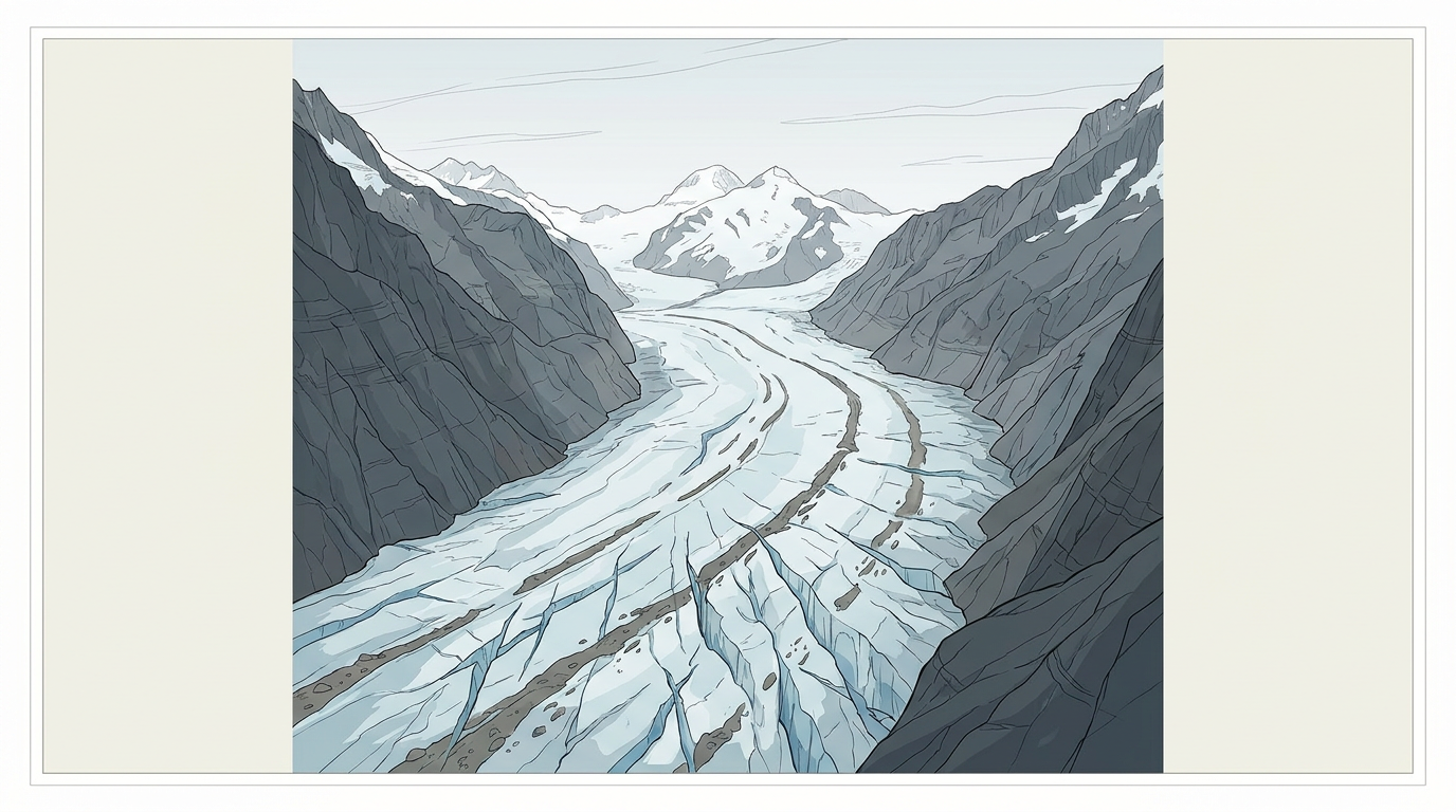
Fig. 6.15 – A valley glacier.
Glaciers In Our Own Mountains
We have many glaciers in our country, moving down the slopes and valleys in the Himalayas. The higher reaches of Uttaranchal, Himachal Pradesh and Jammu and Kashmir are places to see some of them.
The link between this ice and the rivers of the plains is direct. The river Bhagirathi is basically fed by meltwaters from under the snout, called Gaumukh, of the Gangotri glacier — the snout being the lower end of a glacier, where the ice finally melts. The Alkapuri glacier feeds waters to the Alakananda river. The rivers Alkananda and Bhagirathi join to make the river Ganga near Deoprayag. The Ganga, in that sense, begins as ice.
How Ice Cuts Rock
Erosion by glaciers is tremendous, because of the friction caused by the sheer weight of the ice. Ice by itself is soft. Ice pressed down by hundreds of metres of more ice, and dragged across rock, is not.
The glacier works in two ways. In plucking, it freezes on to the rock beneath and tears blocks away as it moves. The material plucked from the land — usually large-sized angular blocks and fragments — then gets dragged along the floors or the sides of the valleys, and causes great damage through abrasion, the grinding of the rock by the debris the ice is carrying. The glacier, like the river, cuts with its tools.
Glaciers can cause significant damage even to un-weathered rocks — rock that has not been softened or loosened beforehand — and can reduce high mountains into low hills and plains. As glaciers continue to move, debris gets removed and divides get lowered.
Eventually the slope is reduced to such an extent that the glaciers will stop moving, because gravity has no gradient left to pull them down. What is left behind is a mass of low hills and vast outwash plains, along with other depositional features. Fig. 6.16 and Fig. 6.18 show various glacial erosional and depositional forms described in the text.
6.4.1 Erosional Landforms
6.4.1.1 Cirque
Cirques are the most common of landforms in glaciated mountains. They are quite often found at the heads of glacial valleys, which is where snow gathers first and ice is thickest. The accumulated ice cuts these cirques while moving down from the mountain tops.
They are deep, long and wide troughs or basins with very steep concave to vertically dropping high walls at the head as well as at the sides. A lake of water can be seen quite often within a cirque after the glacier disappears, because the basin holds meltwater and rain. Such lakes are called cirque or tarn lakes.
There can be two or more cirques, one leading into another down below in a stepped sequence, like a staircase of basins cut into the mountainside.
6.4.1.2 Horns And Serrated Ridges
Horns form through headward erosion of the cirque walls — that is, the cirque eats backwards into the mountain, at its head. If three or more radiating glaciers cut headward until their cirques meet, what is left between them is a high, sharp pointed and steep sided peak. That peak is a horn.
The highest peak in the Alps, the Matterhorn, and the highest peak in the Himalayas, Everest, are in fact horns, formed through the headward erosion of radiating cirques. The sharpest summits on earth are not built up; they are what remains when several glaciers have cut in from every side.
The divides between cirque side walls or head walls get narrow because of progressive erosion, and turn into serrated or saw-toothed ridges. These are sometimes referred to as arêtes, with a very sharp crest and a zig-zag outline. An arête is a wall cut from both faces at once.
6.4.1.3 Glacial Valleys/Troughs
Glaciated valleys are trough-like and U-shaped, with broad floors and relatively smooth but steep sides. The difference from a river valley is in the cross-section. A river cuts with a narrow line of water and leaves a V; a glacier fills the whole valley and grinds the floor and both walls, so it leaves a U.
The valleys may contain littered debris, or debris shaped as moraines, with a swampy appearance. There may be lakes gouged out of the rocky floor by the ice, or lakes formed by debris ponding the water back within the valleys.
There can be hanging valleys at an elevation on one or both sides of the main glacial valley. A tributary glacier cuts its floor less deeply than the main glacier, so when the ice melts its valley is left standing high above the main trough, and it hangs. The faces of divides or spurs of such hanging valleys, where they open into the main glacial valley, are quite often truncated by the main ice stream, which gives them an appearance like triangular facets.
Very deep glacial troughs filled with sea water, and making up shorelines in high latitudes, are called fjords or fiords. The ice cut the trough when sea level was lower; the sea has since walked into it.
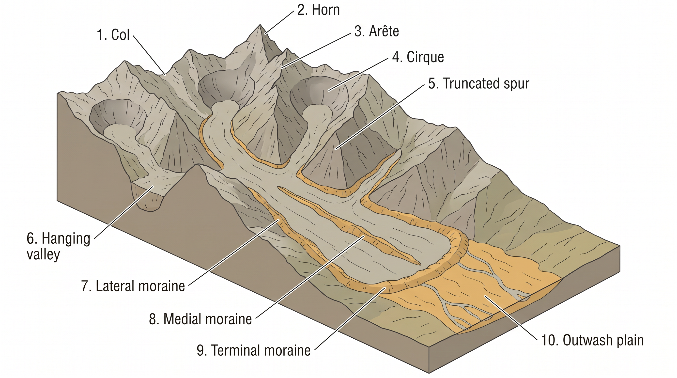
Fig. 6.16 – Glacial erosional and depositional forms.
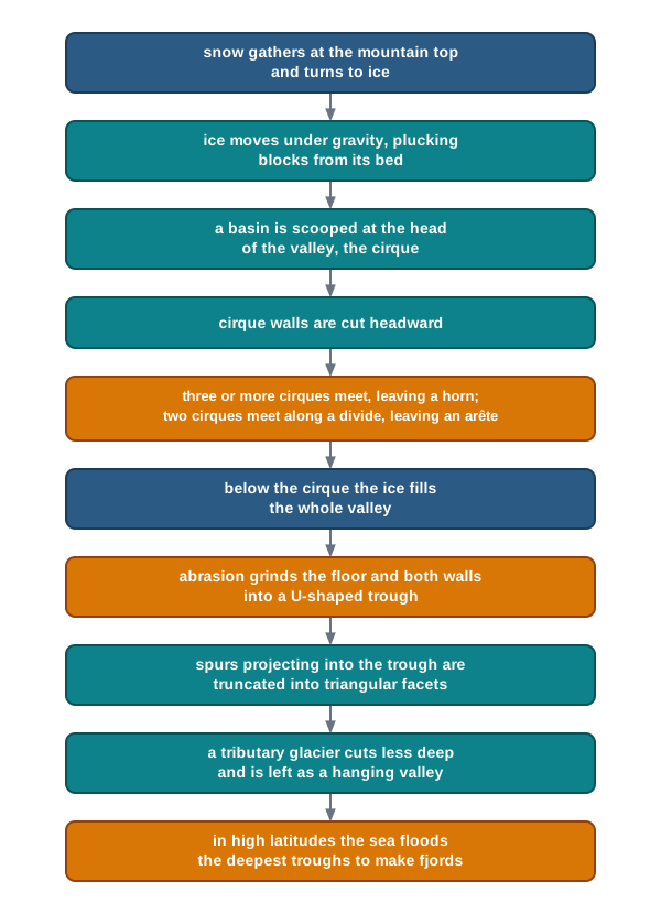
Fig. 6.17 – Formation of glacial erosional landforms.
6.4.2 Depositional Landforms
Glaciers deposit two kinds of material, and telling them apart is the key to the whole of this subsection.
The first is glacial till — the unassorted coarse and fine debris dropped by the melting glaciers. Unassorted means unsorted: boulders, sand and clay all lie mixed together, because ice does not sort what it carries. Most of the rock fragments in till are angular to sub-angular in form, since they were plucked from rock and never rolled far enough to be rounded.
The second is made by water, not ice. Streams form by melting ice at the bottom, the sides or the lower ends of glaciers. Some amount of rock debris, small enough to be carried by such melt-water streams, is washed down and deposited. Such glacio-fluvial deposits — deposits made by water coming from ice — are called outwash deposits.
Unlike till deposits, the outwash deposits are roughly stratified and assorted, because flowing water always drops the heaviest material first and carries the lightest furthest. The rock fragments in outwash deposits are somewhat rounded at their edges, having been knocked about in the stream. Fig. 6.18 shows a few depositional landforms commonly found in glaciated areas.
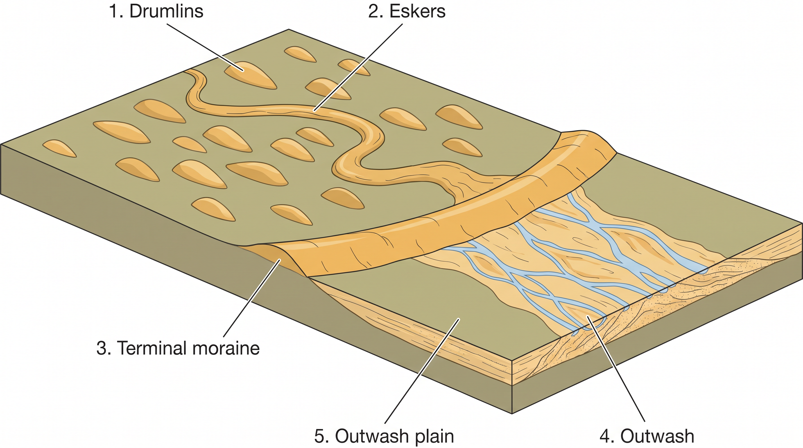
Fig. 6.18 – Glacial depositional landforms.
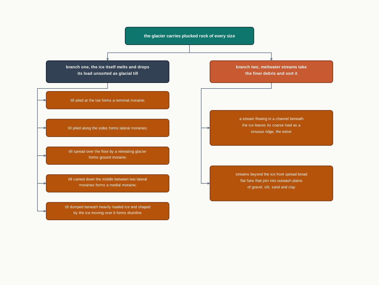
Fig. 6.19 – Formation of glacial depositional landforms.
6.4.2.1 Moraines
Moraines are long ridges of deposits of glacial till. Where the till is piled tells you what the moraine is called.
Terminal moraines are long ridges of debris deposited at the end, or toe, of the glacier — the line where the ice stopped advancing and melted, dropping everything it had brought. Lateral moraines form along the sides, parallel to the glacial valleys. The lateral moraines may join a terminal moraine, forming a horse-shoe shaped ridge (Fig. 6.16), which is simply the outline of the ice front drawn in rubble.
There can be many lateral moraines on either side in a glacial valley. These moraines partly or fully owe their origin to glacio-fluvial waters pushing up materials to the sides of the glaciers.
Many valley glaciers retreating rapidly leave an irregular sheet of till over their valley floors. Such deposits, varying greatly in thickness and in surface topography, are called ground moraines. The moraine in the centre of the glacial valley, flanked by lateral moraines, is called a medial moraine. Medial moraines are imperfectly formed as compared to lateral moraines, and sometimes they are indistinguishable from ground moraines.
6.4.2.2 Eskers
When glaciers melt in summer, the water flows on the surface of the ice, or seeps down along the margins, or even moves through holes in the ice. These waters accumulate beneath the glacier and flow like streams in a channel beneath the ice.
Such streams are unusual in one respect. They flow over the ground — not in a valley cut into the ground — with ice forming their banks. The channel is a tunnel in the ice, held up by the ice.
Very coarse materials like boulders and blocks, along with some minor fractions of rock debris, are carried into this stream and settle in the valley of ice beneath the glacier. After the ice melts, the banks vanish and the deposit is left standing on the ground as a sinuous ridge called an esker. An esker is the cast of a stream that ran inside a glacier.
6.4.2.3 Outwash Plains
The plains at the foot of the glacial mountains, or beyond the limits of continental ice sheets, are covered with glacio-fluvial deposits in the form of broad flat alluvial fans. These fans may join laterally to form outwash plains of gravel, silt, sand and clay.
6.4.2.4 Drumlins
Drumlins are smooth, oval shaped, ridge-like features composed mainly of glacial till, with some masses of gravel and sand in them. The long axes of drumlins are parallel to the direction of ice movement, because they were shaped by ice moving over them.
They may measure up to 1 km in length and 30 m or so in height. One end of the drumlin, the end facing the glacier, is called the stoss end; it is blunter and steeper than the other end, which is called the tail.
Drumlins form due to the dumping of rock debris beneath heavily loaded ice, through fissures in the glacier. The stoss end gets blunted due to the pushing by the moving ice, while the tail is left long and tapering behind.
That asymmetry makes the drumlin useful. Drumlins give an indication of the direction of glacier movement, long after the glacier itself is gone: the blunt end faced the ice, and the tail points the way the ice was going.
6.5 Waves And Currents
Coastal processes are the most dynamic, and hence the most destructive, of all the processes in this chapter. A coast is the one place where land, water and air meet, and where an agent strikes the same line of rock or sand thousands of times a day. That is reason enough to want to know how coastal processes work and what forms they leave.
Some of the changes along the coasts take place very fast. At one place, there can be erosion in one season and deposition in another — the beach that vanishes before the monsoon is back by the end of it. Nothing else in this chapter moves at that speed.
What The Waves Do
Most of the changes along the coasts are accomplished by waves. When waves break, the water is thrown with great force onto the shore, and simultaneously there is a great churning of sediments on the sea bottom. The blow lands on the land, and the load is stirred up in the water at the same moment.
The constant impact of breaking waves drastically affects the coasts. Storm waves and tsunami waves can cause far-reaching changes in a short period of time, far more than normal breaking waves can. As the wave environment changes, the intensity of the force of the breaking waves changes with it. If you do not already know the forces that generate waves and currents, look them up in the chapter on movements in ocean waters.
Other than the action of waves, the coastal landforms depend upon two further conditions. The first is the configuration of the land and the sea floor — how steeply the land goes down, and what shape the floor offshore has. The second is whether the coast is advancing, that is emerging, seaward, or retreating, that is submerging, landward.
Assuming sea level to be constant, two types of coasts are considered to explain the evolution of coastal landforms: high, rocky coasts, which are submerged coasts; and low, smooth and gently sloping sedimentary coasts, which are emerged coasts.
6.5.1 High Rocky Coasts
Along the high rocky coasts, the rivers appear to have been drowned, and the coastline is highly irregular. The coastline appears highly indented, with the water pushing far into the land wherever a valley meets it. Where glacial valleys, the fjords, are present, the water extends deep inland along them.
The hill sides drop off sharply into the water. The shores do not show any depositional landforms initially, because there is no gentle floor for material to rest on. Erosion features dominate.
Along high rocky coasts, waves break with great force against the land, shaping the hill sides into cliffs. With constant pounding by the waves, the cliffs recede — they retreat inland, undercut at their base — leaving a wave-cut platform in front of the sea cliff. Waves gradually minimise the irregularities along the shore, because a headland sticking out into the sea takes the heaviest attack and is cut back first.
The materials which fall off and are removed from the sea cliffs gradually break into smaller fragments and roll to roundness, and they get deposited in the offshore zone. After a considerable period of cliff development and retreat, when the coastline turns somewhat smooth, and with the addition of some more material to this deposit in the offshore, a wave-built terrace would develop in front of the wave-cut terrace. The debris of the cliff builds the floor over which the next waves must travel.
As the erosion along the coast takes place, a good supply of material becomes available to longshore currents — currents that run along the shore rather than into it — and to the waves. They deposit this material as beaches along the shore and as bars, which are long ridges of sand and/or shingle lying parallel to the coast in the nearshore zone.
Bars are submerged features. When bars show up above water, they are called barrier bars. A barrier bar which gets keyed up to the headland of a bay — that is, joined at one end to the high land — is called a spit. When barrier bars and spits form at the mouth of a bay and block it, a lagoon forms behind them, a body of water cut off from the open sea. The lagoons would gradually get filled up by sediments from the land, giving rise to a coastal plain.
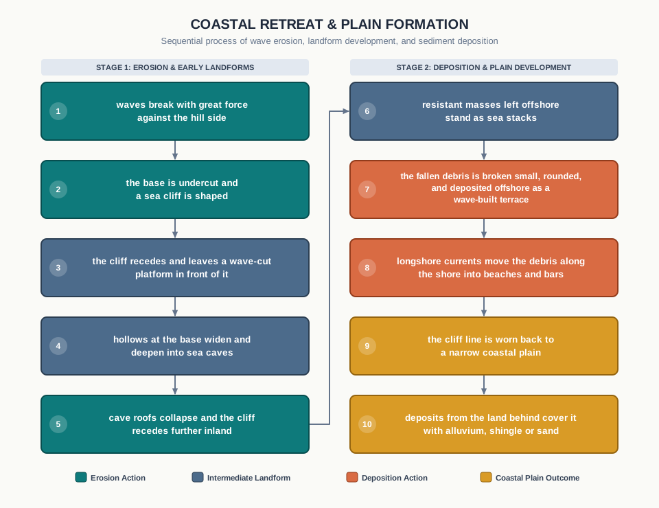
Fig. 6.21 – Coastal landform evolution on a rocky coast.
6.5.2 Low Sedimentary Coasts
Along low sedimentary coasts, the rivers appear to extend their length, by building coastal plains and deltas. The land is winning ground from the sea rather than losing it.
The coastline appears smooth, with occasional incursions of water in the form of lagoons and tidal creeks — narrow channels that the tide runs up and down. The land slopes gently into the water, and marshes and swamps may abound along the coasts. Depositional features dominate.
When waves break over a gently sloping sedimentary coast, the bottom sediments get churned and move readily, building bars, barrier bars, spits and lagoons. Lagoons would eventually turn into a swamp, which would subsequently turn into a coastal plain.
The maintenance of these depositional features depends upon a steady supply of materials. A beach or a bar is not a permanent structure but a balance: it lasts only as long as sand keeps arriving to replace the sand the waves take away. Storm and tsunami waves, however, cause drastic changes irrespective of the supply of sediments. Large rivers, which bring lots of sediments, build deltas along low sedimentary coasts.
Our own coasts show both types, one on each side of the peninsula. The west coast of our country is a high rocky retreating coast, and erosional forms dominate along it. The east coast of India is a low sedimentary coast, and depositional forms dominate along it.
6.5.3 Erosional Landforms
6.5.3.1 Cliffs, Terraces, Caves And Stacks
Wave-cut cliffs and terraces are the two forms usually found where erosion is the dominant shore process. Almost all sea cliffs are steep, and they may range from a few m to 30 m or even more in height.
At the foot of such cliffs there may be a flat or gently sloping platform, covered by rock debris derived from the sea cliff behind it. Such platforms, occurring at elevations above the average height of the waves, are called a wave-cut terrace.
The cutting is done at the base. The lashing of waves against the base of the cliff, and the rock debris that gets smashed against the cliff along with the lashing waves, create hollows. These hollows get widened and deepened to form sea caves.
Once the base is hollowed out, the roofs of the caves collapse, and the sea cliffs recede further inland. The retreat of the cliff may leave some remnants of rock standing isolated as small islands just off the shore. Such resistant masses of rock, originally parts of a cliff or a hill, are called sea stacks — the parts the waves could not remove, left standing in water where the land used to be.
Like all other features, sea stacks are also temporary. Eventually the coastal hills and cliffs will disappear because of wave erosion, giving rise to narrow coastal plains. With the onrush of deposits from over the land behind, these plains may get covered up by alluvium, or they may get covered up by shingle or sand to form a wide beach.
6.5.4 Depositional Landforms
6.5.4.1 Beaches And Dunes
Beaches are characteristic of shorelines that are dominated by deposition, but they may occur as patches along even the rugged shores. Most of the sediment making up the beaches comes from the land, carried down by the streams and rivers, or from wave erosion of the coast itself.
Beaches are temporary features, and this is the single most important thing to understand about them. The sandy beach which appears so permanent may be reduced to a very narrow strip of coarse pebbles in some other season, when the waves take away more sand than they bring.
Most of the beaches are made up of sand sized materials. Beaches called shingle beaches contain excessively small pebbles and even cobbles instead.
Just behind the beach, the sands lifted and winnowed from over the beach surfaces — that is, blown out and sorted by the wind, which takes the fine grains and leaves the coarse — will be deposited as sand dunes. Sand dunes forming long ridges parallel to the coastline are very common along low sedimentary coasts.
6.5.4.2 Bars, Barriers And Spits
A ridge of sand and shingle formed in the sea in the off-shore zone, lying approximately parallel to the coast, is called an off-shore bar. An off-shore bar which is exposed due to the further addition of sand is termed a barrier bar.
The off-shore bars and barriers commonly form across the mouth of a river or at the entrance of a bay — that is, exactly where the coastline has a gap in it. Sometimes such barrier bars get keyed up to one end of the bay, when they are called spits (Fig. 6.20). Spits may also develop attached to headlands or hills.
The barriers, bars and spits at the mouth of the bay gradually extend, leaving only a small opening of the bay into the sea, and the bay will eventually develop into a lagoon. The lagoons get filled up gradually by sediment coming from the land or from the beach itself, aided by the wind, and a broad and wide coastal plain may develop, replacing a lagoon.
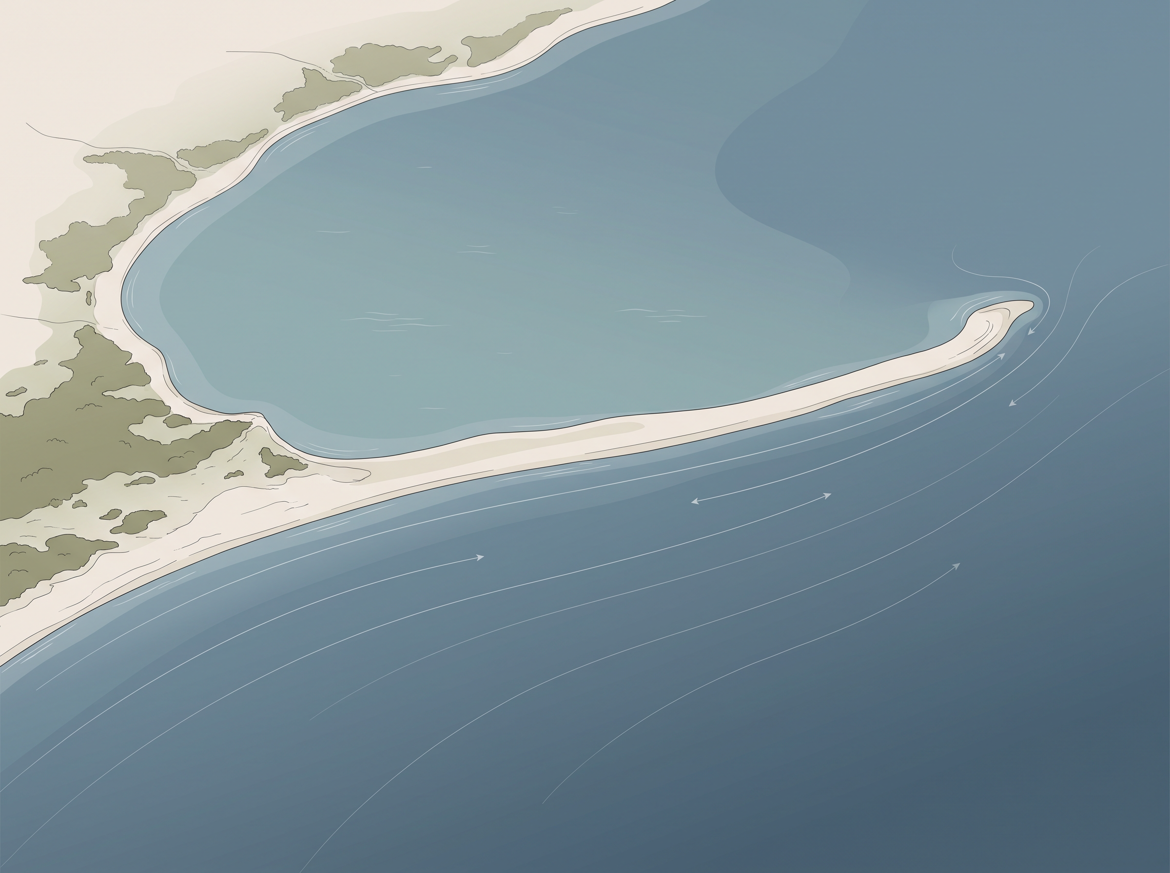
Fig. 6.20 – Spit in the Godavari river delta.
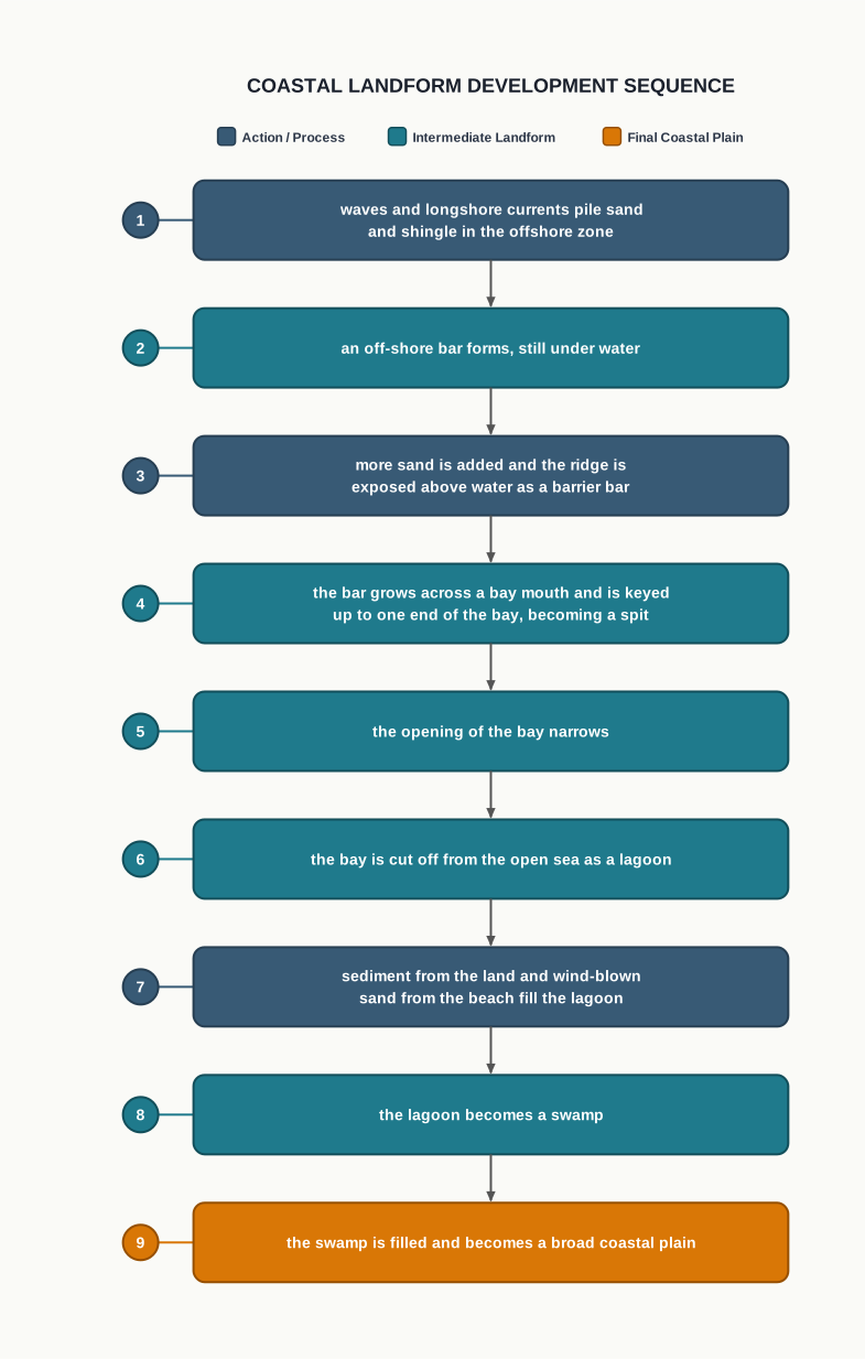
Fig. 6.22 – Coastal landform evolution on a sedimentary coast.
Why The Coast Defends Itself
These forms are not merely scenery, and the last one in the sequence matters most to the people living behind it. The coastal off-shore bars offer the first buffer, or defence, against a storm or a tsunami, by absorbing most of its destructive force. Then come the barriers, the beaches, the beach dunes and the mangroves, if any, to absorb what is left of the destructive force of storm and tsunami waves.
Each of those forms exists only because sand keeps arriving to maintain it. So, if we do anything which disturbs the ‘sediment budget’ — the balance between the sand a stretch of coast receives and the sand it loses — and disturbs the mangroves along the coast, these coastal forms will get eroded away. Then human habitations must bear the first strike of storm and tsunami waves themselves.
6.6 Winds
Wind is one of the two dominant agents in hot deserts. It matters there, and mostly only there, because a desert gives the wind what no other landscape does: dry, bare, loose material with no vegetation and no moisture to hold it down.
Why Desert Air Will Not Sit Still
The desert floors get heated up too much and too quickly, because they are dry and barren. There is no water to absorb the heat and no plant cover to shade the ground.
The heated floors heat up the air directly above them. Hot air is lighter, so it rises, and the result is upward movement of air with turbulence. Any obstruction in its path sets up eddies, whirlwinds, updrafts and downdrafts. Winds also move along the desert floors with great speed, and the obstructions in their path create further turbulence. And, of course, there are storm winds, which are very destructive.
The Three Ways Wind Attacks Rock
Winds cause deflation, abrasion and impact. Deflation includes the lifting and removal of dust and smaller particles from the surface of rocks — the wind simply takes the loose material away, leaving the surface stripped.
In the transportation process, the sand and silt the wind is carrying act as effective tools to abrade the land surface. Abrasion here is the wearing away of rock by the grains flying against it. Impact is simply the sheer force of momentum, which occurs when sand is blown into or against a rock surface. It is similar to a sand-blasting operation, in which grit is fired at a surface to clean or cut it.
The wind action creates a number of interesting erosional and depositional features in the deserts. But it does not create them alone.
The Other Agent In The Desert
In fact, many features of the deserts owe their formation to mass wasting and to running water as sheet floods. Though rain is scarce in deserts, it comes down torrentially, in a short period of time, and a great deal of work is done in that short time.
The desert rocks are devoid of vegetation and are exposed to mechanical and chemical weathering because of drastic diurnal temperature changes — the large difference between day and night temperature, which expands and contracts the rock daily. So they decay faster, and the torrential rains help in removing the weathered materials easily.
That means the weathered debris in deserts is moved not only by wind, but also by rain and sheet wash. The wind moves the fine materials; the general mass erosion is accomplished mainly through sheet floods or sheet wash, in which rain runs across the whole surface at once. Stream channels in desert areas are broad, smooth and indefinite, and they flow for only a brief time after the rains.
6.6.1 Erosional Landforms
6.6.1.1 Pediments And Pediplains
Landscape evolution in deserts is primarily concerned with the formation and extension of pediments. Gently inclined rocky floors close to the mountains, at their foot, with or without a thin cover of debris, are called pediments. Such rocky floors form through the erosion of the mountain front, by a combination of lateral erosion by streams and sheet flooding.
Erosion starts along the steep margins of the landmass, or along the steep sides of tectonically controlled steep incision features over the landmass — that is, steep faces produced by movements of the crust itself.
Once pediments are formed, with a steep wash slope followed by a cliff or free face above it, the steep wash slope and free face retreat backwards. The slope does not get gentler; it keeps its angle and simply moves back, like a wall being demolished face-first. This method of erosion is termed parallel retreat of slopes through backwasting.
So, through the parallel retreat of slopes, the pediments extend backwards at the expense of the mountain front. Gradually, the mountain gets reduced, leaving an inselberg, which is a remnant of the mountain standing above the plain. That is how the high relief in desert areas is reduced to the low featureless plains called pediplains.
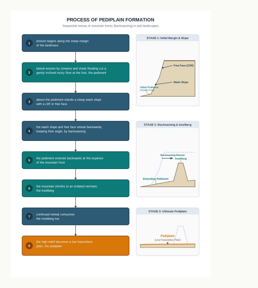
Fig. 6.23 – Evolution of desert landscapes.
6.6.1.2 Playas
Plains are by far the most prominent landforms in the deserts. That is worth pausing on, because a desert is usually pictured as dunes.
In basins with mountains and hills around and along them, the drainage is towards the centre of the basin, and there is no outlet to the sea. Sediment washed from the basin margins is deposited gradually, and a nearly level plain forms at the centre of the basin.
In times of sufficient water, this plain is covered up by a shallow water body. Such types of shallow lakes are called playas. The water is retained only for a short duration, because evaporation in a desert is fierce. Quite often the playas contain a good deposition of salts, because the water leaves as vapour and the salts it carried stay behind. A playa plain covered up by salts is called an alkali flat.
6.6.1.3 Deflation Hollows And Caves
The weathered mantle from over the rocks, or bare soil, gets blown out by the persistent movement of wind currents in one direction. Persistence is what makes this work: the same wind, taking a little each time, from the same place. This process may create shallow depressions called deflation hollows.
Deflation also creates numerous small pits or cavities over rock surfaces. The rock faces suffer the impact and abrasion of wind-borne sand, and first, shallow depressions called blow outs are created. Some of the blow outs become deeper and wider, until they are fit to be called caves.
6.6.1.4 Mushroom, Table And Pedestal Rocks
Many rock-outcrops in the deserts are easily susceptible to wind deflation and abrasion, and are worn out quickly. What survives is the resistant rock, and it survives in a very particular shape.
The remnants of resistant rock are left polished beautifully in the shape of a mushroom, with a slender stalk and a broad, rounded, pear shaped cap above. The reason the stalk is slender is that the sand the wind carries travels close to the ground: the lower part of the outcrop is struck hardest and cut back fastest, while the top is barely touched.
Sometimes the top surface is broad like a table top, and quite often the remnants stand out like pedestals.
6.6.2 Depositional Landforms
Wind is a good sorting agent — better, in fact, than water. Depending upon the velocity of the wind, different sizes of grains are moved along the floors by rolling or by saltation, which is the bouncing of grains in short hops along the surface, while the finest are carried in suspension, held up within the moving air.
In this process of transportation itself, the materials get sorted, because each size travels in its own way. When the wind slows or begins to die down, the grains begin to settle, each according to its size and its critical velocity — the speed below which the wind can no longer hold it. So, in depositional landforms made by wind, a good sorting of grains can be found.
Wind is everywhere. So, wherever there is a good source of sand and a constant wind direction, depositional features in arid regions can develop anywhere.
6.6.2.1 Sand Dunes
Dry hot deserts are good places for sand dune formation. But sand alone is not enough. Obstacles to initiate dune formation are equally important, because sand begins to pile where something makes the wind drop it. There can be a great variety of dune forms (Fig. 6.24).
Crescent shaped dunes called barchans, with the points or wings directed away from the wind direction — that is, downwind — form where the wind direction is constant and moderate, and where the original surface over which the sand is moving is almost uniform.
Parabolic dunes form when sandy surfaces are partially covered with vegetation. The plants pin down the wings while the middle is blown forward. That means parabolic dunes are reversed barchans, with the wind direction being the same.
Seif is similar to a barchan, with a small difference. A seif has only one wing or point. This happens when there is a shift in wind conditions. The lone wings of seifs can grow very long and high.
Longitudinal dunes form when the supply of sand is poor and the wind direction is constant. They appear as long ridges of considerable length but low in height.
Transverse dunes are aligned perpendicular to the wind direction. These dunes form when the wind direction is constant and the source of sand is an elongated feature lying at right angles to the wind direction. They may be very long and low in height.
When sand is plenty, quite often the regular shaped dunes coalesce, running into one another, and lose their individual characteristics. Most of the dunes in the deserts shift, moving grain by grain in the direction of the wind, and only a few of them will get stabilised, especially near human habitations, where plantings and structures hold the sand in place.
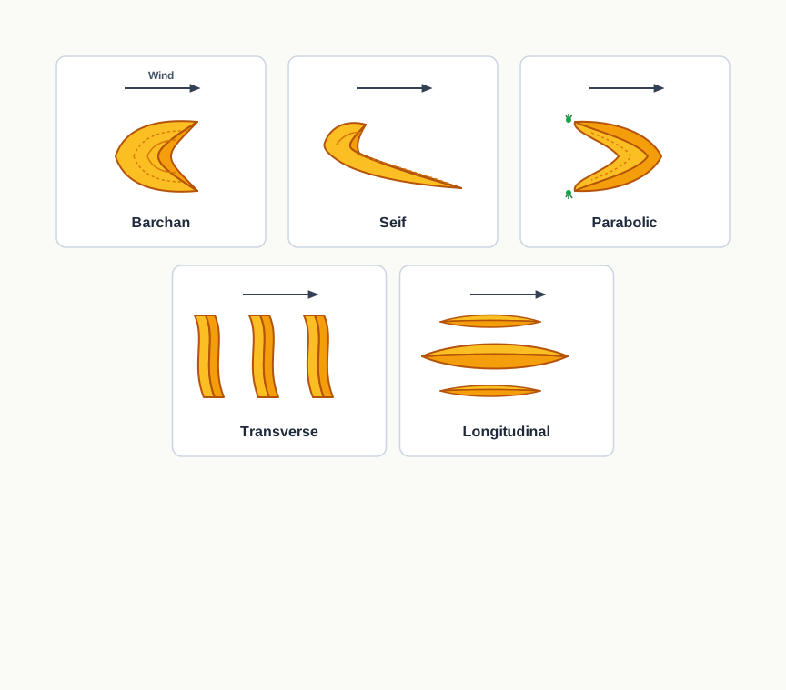
Fig. 6.24 – Types of sand dunes.
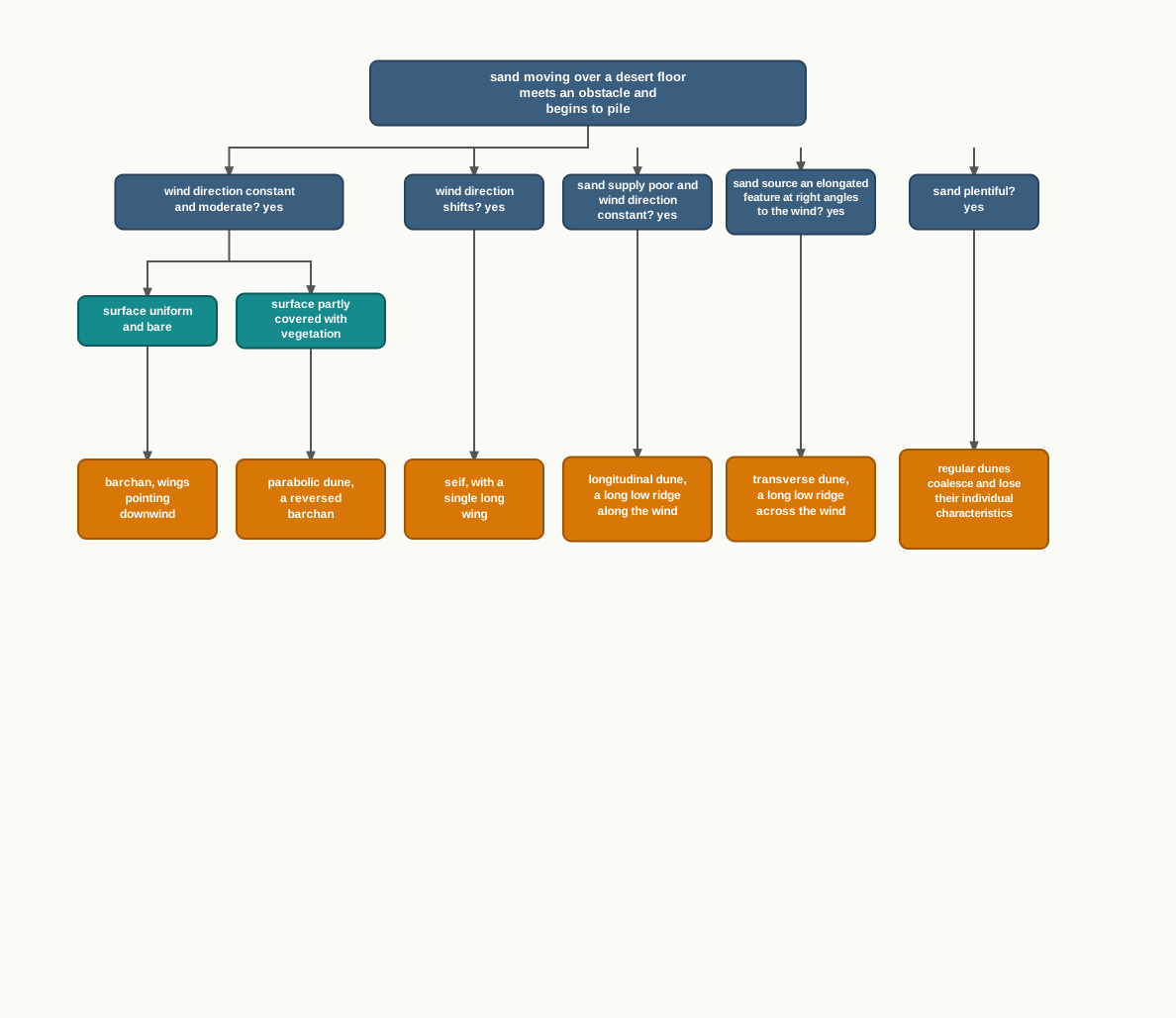
Fig. 6.25 – Formation of various sand dunes.
6.7 Summary
- Weathering breaks rock where it stands; the geomorphic agents — running water, groundwater, glaciers, waves and wind — then remove that material by erosion and drop it again by deposition. Both acts change the surface.
- A landform is a small to medium tract of the earth’s surface; several related landforms make up a landscape. Every landform has a beginning, and every landform is still being changed.
- Evolution means the transformation of one landform into another, or of a landform after it is formed. Climatic change and the vertical or horizontal movement of landmasses alter the processes, and so alter the forms. A landmass passes through stages comparable to youth, mature and old age.
- Running water is the most important agent in humid regions. It works as overland flow, which sheet-erodes the surface, and as linear flow in streams and rivers.
- Steep gradients favour down-cutting; gentle gradients favour lateral erosion and deposition. The gentler the channel, the greater the deposition. Continued erosion lowers hills and divides until a peneplain with monadnocks remains.
- Rills grow into gullies and gullies into valleys. Gorges have near-vertical walls of equal width top and bottom; canyons are wider at the top and step down in horizontal beds. Potholes are ground out by rotating pebbles, and plunge pools at the foot of waterfalls.
- Meanders are cut into hard rock as incised meanders; river terraces mark the levels of former river beds.
- Rivers build alluvial fans where the mountain slope breaks, deltas where the load is dropped into the sea, and floodplains with natural levees and point bars. A meander is a channel pattern, not a landform, and a cut-off meander is left as an ox-bow lake.
- Groundwater erodes chiefly by chemistry, and only in limestone and dolomite. Solution makes swallow holes, sinkholes, dolines, uvalas, lapies, limestone pavements and caves — together, karst topography.
- The same calcium carbonate is redeposited inside caves, as stalactites hanging from the roof, stalagmites rising from the floor, and pillars where the two fuse.
- Glaciers move slowly under gravity and cut with the debris they pluck. They leave cirques, tarn lakes, horns, arêtes, U-shaped troughs, hanging valleys and fjords.
- Glacial till is unsorted and angular; outwash deposits, laid by meltwater, are sorted and rounded. Till builds terminal, lateral, ground and medial moraines and drumlins; meltwater builds eskers and outwash plains.
- Coasts change fastest of all. High rocky coasts are submerged and erosional — cliffs, wave-cut terraces, sea caves and sea stacks. Low sedimentary coasts are emerged and depositional — beaches, dunes, bars, barrier bars, spits and lagoons. The west coast of our country is the first kind, the east coast the second.
- Beaches and bars survive only while sand keeps arriving, and they are the coast’s first defence against storm and tsunami waves.
- In hot deserts, wind erodes by deflation, abrasion and impact, leaving deflation hollows, blow outs and mushroom, table and pedestal rocks. But sheet floods do most of the mass erosion, and the parallel retreat of slopes turns mountains into pediments, inselbergs and finally pediplains.
- Wind sorts what it carries, so its deposits are well sorted. Dune form records wind conditions: barchan, parabolic, seif, longitudinal and transverse.
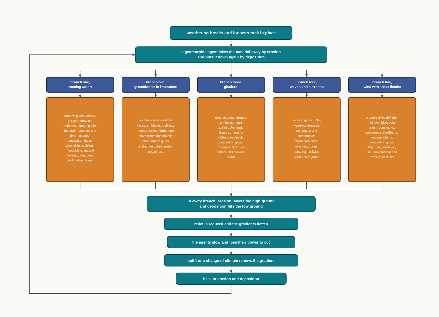
Fig. 6.26 – Summary of geomorphic agents and their landforms.
What This Chapter Cannot Tell You
The stages of youth, mature and old age describe an ideal sequence on an unchanging landmass. Real landmasses are uplifted and warped while the agents are still at work, so a landscape can be young in one part of a basin and old in another.
The chapter gives you the forms and the processes, but almost no rates and no dates. It does not say how many years a gorge took to cut, how fast a cliff is retreating, or when the ice left a valley now empty of it.
And it names the agent that dominates each landscape without saying how much the others contributed. A desert is shaped by wind and by sheet flood together, and this chapter cannot tell you, for any particular desert, in what proportion.
6.8 NCERT Questions
In which of the following stages of landform development, downward cutting is dominated?
- Youth stage
- Late mature stage
- Early mature stage
- Old stage
A deep valley characterised by steep step-like side slopes is known as
- U-shaped valley
- Gorge
- Blind valley
- Canyon
In which one of the following regions the chemical weathering process is more dominant than the mechanical process?
- Humid region
- Limestone region
- Arid region
- Glacier region
Which one of the following sentences best defines the term ‘Lapies’?
- A small to medium sized shallow depression
- A landform whose opening is more or less circular at the top and funnel shaped towards bottom
- A landform formed due to dripping water from surface
- An irregular surface with sharp pinnacles, grooves and ridges
A deep, long and wide trough or basin with very steep concave high walls at its head as well as in sides is known as:
- Cirque
- Glacial valley
- Lateral Moraine
- Esker
What do incised meanders in rocks and meanders in plains of alluvium indicate? (30 words)
Explain the evolution of valley sinks or uvalas. (30 words)
Underground flow of water is more common than surface run-off in limestone areas. Why? (30 words)
Glacial valleys show up many linear depositional forms. Give their locations and names. (30 words)
How does wind perform its task in desert areas? Is it the only agent responsible for the erosional features in the deserts? (30 words)
Running water is by far the most dominating geomorphic agent in shaping the earth’s surface in humid as well as in arid climates. Explain. (150 words)
Limestones behave differently in humid and arid climates. Why? What is the dominant and almost exclusive geomorphic process in limestone areas and what are its results? (150 words)
How do glaciers accomplish the work of reducing high mountains into low hills and plains? (150 words)
6.9 Check Your Concepts
Look at Fig. 6.24. For a barchan and for a parabolic dune, state where the wings point in relation to the wind, and explain what condition of the desert surface makes the difference between the two forms.
Both an alluvial fan and a delta are made of material a river drops when it can no longer carry it. Yet the deposits of a delta are well sorted and clearly stratified, and those of a fan are not. Explain why.
Using Fig. 6.9, reconstruct in order the steps by which a slight irregularity in a river bank ends as an ox-bow lake. At each step, say which bank is being eroded and which is receiving deposits.
A drumlin has a blunt, steep stoss end and a long tapering tail. Explain how each end got its shape, and how a geographer who has never seen the glacier can use the drumlin to say which way the ice was moving.
The chapter states that the west coast of our country is a high rocky retreating coast and the east coast is a low sedimentary coast. For each coast, name the dominant process and three landforms you would expect to find, and say why the two coasts behave so differently.
Beaches and bars are described as temporary features. Explain what keeps them in existence, and trace what follows for the human habitations behind them when the ‘sediment budget’ of a coast is disturbed.
A peneplain and a pediplain are both low plains left where high relief once stood. Using the chapter’s account of each, explain how the agent, the climate and the manner in which the slopes are worn back differ between the two.
Fig. 6.16 shows cirques, horns, arêtes, a U-shaped trough, hanging valleys and moraines in a single landscape. State two things the figure does establish about the glacier that made them, and two things it cannot tell you.