Chapter 13: Movements Of Ocean Water
The tide is out, and the sand runs flat and wet to a line of gentle surf. You walk down to where the water folds over your feet, and a wave arrives — one wave, then another, evenly spaced, each collapsing into a hiss of foam. Stand there long enough and something strange becomes clear. The water does not run up the beach and keep going. It rises around your ankles, then slides back, and the sand is where it was. Yet the waves keep coming, hour after hour, from a horizon that shows no storm at all.
That last wave may have been born days ago and an ocean away — perhaps by a gale in another hemisphere — and travelled thousands of kilometres to break here. What crossed all that water was not the water itself. It was energy, handed from one patch of sea to the next, lifting each in turn and setting it back down. Only at the very end, where the sea floor rises to meet it, does the wave finally trip, steepen and spill as surf.
Behind that single wave lie the three great motions of the sea. Waves ride the surface. Tides lift the whole ocean twice a day. And beneath both, vast currents circle the basins like rivers without banks. This chapter follows all three — and asks what drives each of them.
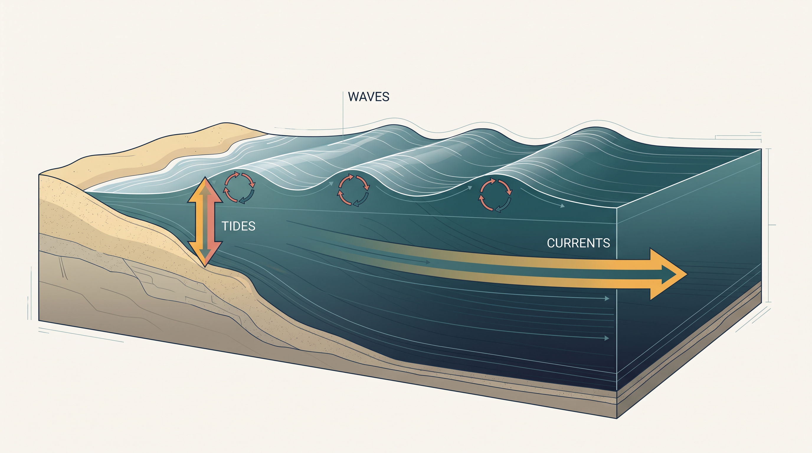
Fig. 13.0 – The three motions of ocean water.
Keep these in mind as you read — by the end of the chapter you will be able to answer every one of them.
13.1 The Ocean Is Dynamic
The ocean is never still. Its water is in constant motion, driven partly by its own physical properties and partly by forces acting on it from outside.
Two kinds of things keep the sea moving. The first are the water’s own properties: its temperature, its salinity and its density. Salinity is the amount of dissolved salt in a body of seawater. Density is how much mass is packed into a given volume of water — denser water is heavier for its size than lighter water. The second are external forces: the pull of the sun and the moon, and the push of the winds. Together, these set the whole ocean moving.
Two Directions Of Motion
All of that movement falls into two broad kinds. There is horizontal motion, which carries water across the surface, and there is vertical motion, which lifts water up and sets it back down. Almost everything the sea does can be sorted into one of these two.
Horizontal motion itself takes two forms — ocean currents and waves. Ocean currents are the continuous flow of a huge volume of water in a definite direction, moving from one part of the ocean to another rather like a river running inside the sea. Waves are the rolling horizontal motion of the surface, ridge following ridge across open water.
The difference between the two matters. In a current, the water itself is carried along and genuinely travels. In a wave, the water stays roughly where it is; what moves ahead is the shape of the wave — the wave train — not the water making it up.
Vertical motion is the rise and fall of the sea. Its most familiar form is the tide. Tides are the rise and fall of the sea level at a coast, produced by the pull of the moon and the sun, and repeating usually twice a day. There is a second, quieter kind of vertical motion out of sight below the surface: upwelling, in which cold water rises from the depths towards the surface, balanced by the sinking of surface water down into the deep.
These, then, are the ocean’s three great motions — currents and waves running across it, tides and upwelling moving it up and down (Fig. 13.1). The rest of the chapter takes them one at a time, asking in each case what force drives the water and what the movement does.
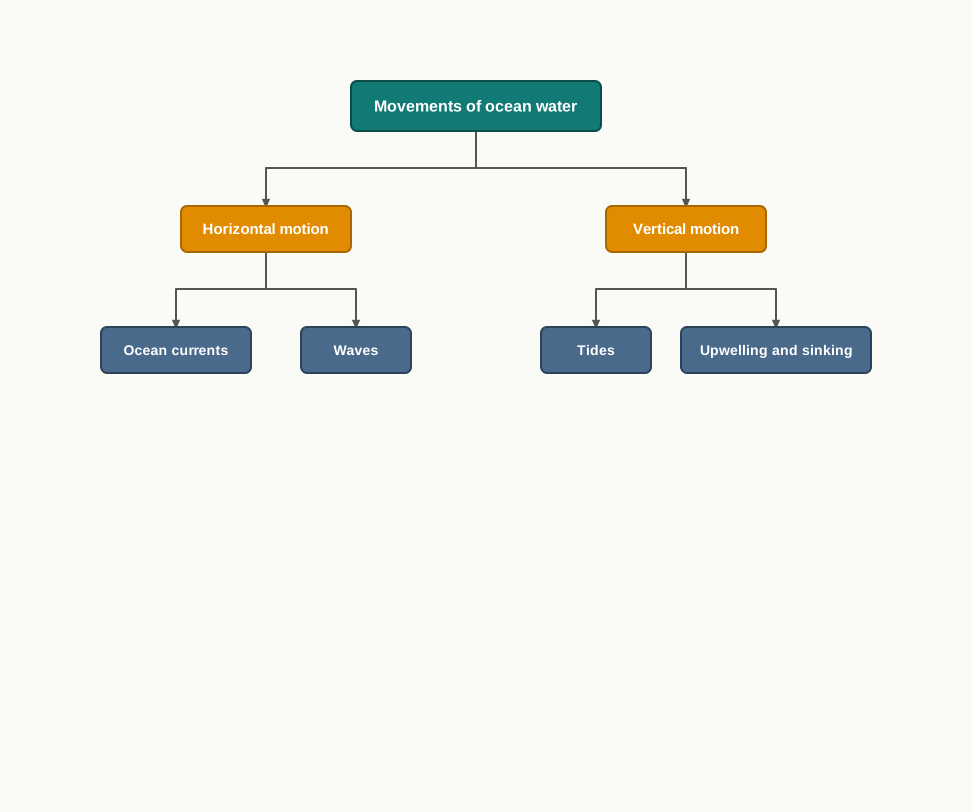
Fig. 13.1 – Classification of ocean water movements.
13.2 Waves
Waves are the most visible movement of the sea — the endless procession of ridges that rolls across the surface and breaks along every shore. To understand them, three questions are worth asking: what does a wave actually carry, how is it born and grown, and why does it finally break.
What A Wave Carries
The first surprise is that a wave carries almost no water. What crosses the ocean surface is energy, not the water as such. As a wave passes, each water particle simply travels in a small circle and returns close to where it began. The particle rises and moves forward as the ridge arrives, then drops and moves back as it goes by. This circling stays near the surface; the movement of the surface water seldom disturbs the still, deep water lying far below.
Because the water only circles in place, the deep bottom of the ocean is left largely undisturbed while great waves pass overhead. What travels the whole distance is the wave form itself, handed on from one patch of sea to the next. Fig. 13.2 traces this: the wave moves to the right while the water beneath turns in closed loops, carrying things up and forward as the wave approaches, and down and back as it passes.
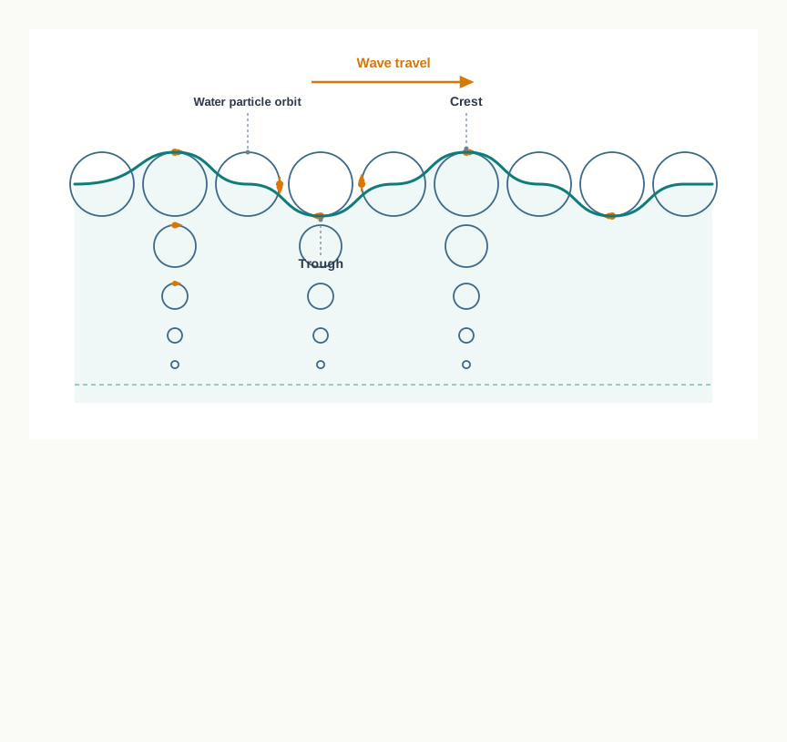
Fig. 13.2 – Motion of waves and water molecules.
How A Wave Is Born And Grows
Almost all waves are made by wind driving against the surface of the water. When a breeze of two knots or less blows over calm water, small ripples appear. A knot is the standard measure of speed used at sea. As the wind strengthens, the ripples grow, until white caps break at the tops of the larger waves.
The wind is the source of a wave’s energy, and a wave keeps drawing on it. Waves grow larger as they travel and go on absorbing energy from the wind that pushes them. How big a wave can finally become depends on the strength of the wind — on how long it blows, and on how wide an area it blows across in a single direction. The largest waves of all are found far out in the open oceans, where wind can work on the water over vast distances.
A wave can outlive the wind that made it and travel enormous distances. Waves may cross thousands of kilometres of ocean before rolling ashore, breaking and dissolving as surf — the churning white water at the beach. A wave’s shape even records where it was born. Steep, choppy waves are young and were probably raised by local wind close by. Long, slow, steady waves have come from far away, sometimes from a storm in another hemisphere.
There is a neat mechanism behind this forward travel. The wind pushes the body of water along, while gravity pulls the raised crests downward. As the falling crest water drops, it shoves the water in the troughs ahead upward, and the wave reappears a little further on. Repeated endlessly, this is what carries the wave across the sea. The whole life of a wave, from the first ripple to breaking surf, is drawn together in Fig. 13.3.
Why A Wave Breaks
A wave that has crossed an ocean untouched changes suddenly at the shore. As it approaches the beach, it slows down, because the moving water begins to drag against the rising sea floor and friction holds it back. The wave behind piles into the wave in front, and the ridge grows steeper and taller.
The wave finally breaks when the water becomes too shallow to support it — specifically, when the depth of water is less than half the wavelength. At that point the base of the wave is held back by the floor while its top runs on, so the crest topples forward and spills as surf.

Fig. 13.3 – The life cycle of a wave.
13.3 Tides
The second great motion of the ocean is vertical: the slow, regular rise and fall of the sea. More precisely, a tide is the periodical rise and fall of the sea level, once or twice a day, caused mainly by the attraction of the sun and the moon. It is one of the most dependable rhythms in nature — a stretch of coast that is under water at noon may be bare sand a few hours later.
Not every change in sea level is a tide. Water can also be pushed about by the weather — by strong winds and by changes in atmospheric pressure — and these movements are called surges. A surge is not regular the way a tide is; it arrives with a storm and passes when the storm does. The study of tides is genuinely difficult, because tides vary greatly from place to place and from time to time in how often they come, how large they are and how high they rise.
How Tides Are Raised
The main cause of tides is gravity — chiefly the moon’s gravitational pull, and to a lesser degree the sun’s. There is a second factor as well. Centrifugal force is the outward force that balances gravity as the earth and moon swing around their common centre of mass. Working together, the moon’s pull and this centrifugal force raise two great tidal bulges — swellings of the ocean — on opposite sides of the earth.
One bulge is easy to picture. On the side of the earth facing the moon, the moon’s pull is strongest, so the water is drawn towards it and heaps up. The second bulge, on the far side of the earth, is the puzzle. There the moon’s attraction is weakest, because that side is farthest away — so instead the centrifugal force wins, and throws a second bulge outward, away from the moon.
The force that actually raises the tide is the difference between these two — the moon’s gravitational attraction on one hand and the centrifugal force on the other. This is called the ‘tide-generating’ force. On the surface nearest the moon, the moon’s pull beats the centrifugal force, giving a net force towards the moon and a bulge there. On the opposite surface, the pull is weaker and the centrifugal force dominates, giving a net force away from the moon and the second bulge (Fig. 13.4). Across the earth’s surface, it is the horizontal part of these tide-generating forces, rather than the vertical part, that does most to pile the water into bulges.
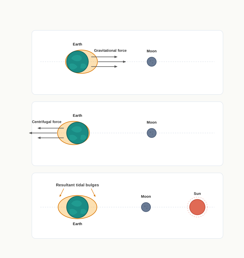
Fig. 13.4 – Gravitational forces, centrifugal force and tidal bulges.
What Shapes A Tide’s Height
The bulges are not the same height everywhere, because the shape of the sea floor and of the coast reworks them. Over wide continental shelves the tidal bulge builds higher. When a bulge runs up against a mid-oceanic island it is cut down and stays low. The outline of a coast matters most of all: bays and estuaries can magnify a tide, and a funnel-shaped bay, narrowing inland, can change tidal heights dramatically by squeezing the same volume of water into an ever-smaller space. When a tide is forced through a narrow channel between islands, or into such bays and estuaries, the fast flow it sets up is called a tidal current.
The most extreme example on earth shows what a funnel-shaped bay can do.
A rise of about 240 cm an hour is faster than it sounds. It means the water climbs more than two metres every hour — quicker than a person can stroll back up a gently shelving beach. That is why the local warning is a real one: walk out for an hour on the Fundy sands beside a steep cliff, and the returning tide can be over your head before you get back to where you started. The number is not just a curiosity; it measures how violently a funnel-shaped coast can amplify an ordinary ocean tide.
13.3.1 Types Of Tides
Tides differ from one coast to another and from one day to the next — in how often they arrive, which way they move, and how high they rise. Two useful ways of sorting them are by frequency, meaning how many tides occur in a day or in 24 hours, and by the positions of the sun and moon, which set the height.
13.3.1.1 Tides Based On Frequency
A semi-diurnal tide is the most common pattern of all: two high tides and two low tides each day, with the two highs, and the two lows, roughly equal in height. A diurnal tide is different — just one high tide and one low tide in a day, again of about the same height as those on neighbouring days. A mixed tide is one whose successive highs or lows differ noticeably in height; mixed tides are common along the west coast of North America and on many islands of the Pacific Ocean.
13.3.1.2 Tides Based On The Sun, Moon And The Earth Positions
How high a high tide rises depends a great deal on where the sun and moon sit in relation to the earth. Two named cases mark the two extremes: spring tides and neap tides.
A spring tide occurs when the sun, the moon and the earth fall into a straight line. Their gravitational pulls then add together, so the tidal bulges grow and the high tides run especially high. This happens twice a month — once at full moon and once at new moon. The name has nothing to do with the season.
A neap tide is the opposite, and falls about seven days after a spring tide. Now the sun and moon stand at right angles as seen from the earth, so their pulls work against one another. The moon’s attraction is more than twice as strong as the sun’s, but it is partly cancelled by the sun’s opposing pull, and the tidal range drops to its smallest. The swing between spring and neap tides is set out in Fig. 13.5.
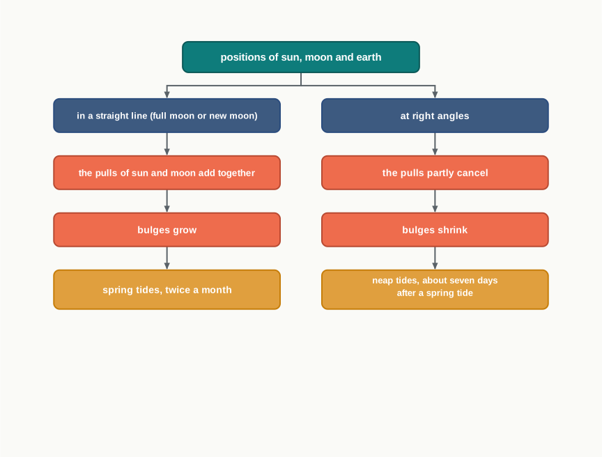
Fig. 13.5 – Formation of spring and neap tides.
Distance matters too, because gravity weakens as things move apart. Once a month the moon’s orbit brings it closest to the earth, a point called perigee, and tides then run unusually high and low, with a range greater than normal. About two weeks later the moon is at moon is at its farthest, called apogee, its pull is weaker, and the tidal ranges fall below their average. The earth’s distance from the sun works the same way over the year. When the earth is closest to the sun, at perihelion, around 3rd January each year, tidal ranges are much greater, with unusually high and unusually low tides. When it is farthest, at aphelion, around 4th July each year, the ranges are much smaller than average.
Two everyday terms describe the tide in motion. The ebb is the time between high tide and low tide, when the water level is falling. The flow, or flood, is the time between low tide and high tide, when the water is rising.
13.3.2 Importance Of Tides
Because tides are set by the positions of the earth, moon and sun, and those positions are known with great accuracy, tides can be predicted long in advance. That predictability is exactly what makes them useful. Navigators and fishermen can plan their work around a timetable of the sea that will not catch them out.
Tidal flows matter most in navigation. Tidal height decides whether a ship can enter a port at all, especially at harbours built near rivers and inside estuaries, where a shallow ‘bar’ — a ridge of sand or silt across the entrance — can block boats until the rising tide lifts them over it. Tides also do useful cleaning work, helping to scour away silted sediment and to flush polluted water out of river estuaries.
Tides are a source of energy as well. Their regular rise and fall can be harnessed to generate electrical power, as it already is in Canada, France, Russia and China. In India, a 3 MW tidal power project — 3 megawatts, a modest amount of electricity — is under way at Durgaduani, in the Sunderbans, the tidal delta region on the coast of West Bengal in eastern India.
13.4 Ocean Currents
The third great motion is the ocean current. Ocean currents are like rivers flowing inside the sea: they carry a regular volume of water along a definite path and in a definite direction. Unlike a wave, a current genuinely moves the water itself, sometimes clear across an ocean.
What sets a current going is a combination of forces, of two kinds. Primary forces start the water moving in the first place. Secondary forces then shape and steer the flow once it is under way.
What Drives A Current
There are four primary forces, and it helps to take them one at a time. The first is heating by solar energy. The sun warms the surface water, and warm water expands and takes up more room. This is why, near the equator, the ocean surface stands about 8 cm higher than in the middle latitudes. That tiny difference creates a very slight slope, and water tends to flow down it.
The second force is wind. Wind blowing across the surface pushes the water along, dragging it forward through the friction between air and water. The third is gravity, which pulls the heaped-up water back down the slope and keeps the gradient changing. The fourth is the Coriolis force — the deflecting effect of the earth’s rotation, which turns any moving water to the right in the northern hemisphere and to the left in the southern hemisphere.
It is this last force that gives ocean currents their most striking feature. As the Coriolis force curves the flow, the water piles up and circles around great loops. These large accumulations of water, and the circular flow around them, are called gyres, and they produce huge circular currents in every ocean basin (Fig. 13.6).
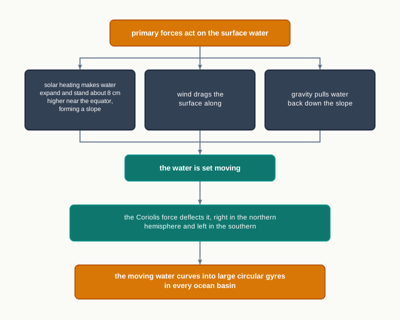
Fig. 13.6 – Forces driving ocean gyres.
Why Currents Rise And Sink
Not all current motion is horizontal. Differences in water density drive water up and down as well. Water with high salinity is denser than water with low salinity, and cold water is denser than warm water. Denser water tends to sink, while lighter water rises. This sets up a slow vertical circulation. Cold-water currents form where cold, dense water at the poles sinks and creeps along towards the equator. To replace it, warm-water currents travel out from the equator along the surface, flowing towards the poles.
13.4.1 Types Of Ocean Currents
Currents can be sorted in two different ways, and it is worth holding both in mind at once.
The first sorting is by depth. Surface currents are the currents of the upper ocean — roughly the top 400 m — and they make up only about 10 per cent of all the water in the ocean. Deep water currents make up the other 90 per cent. These deep flows move around the ocean basins in response to differences in density and gravity: at high latitudes, where the water is cold enough for its density to rise, surface water sinks into the deep basins and drives the deep circulation.
The second sorting is by temperature, and the two types are near-mirror images of each other. Cold currents carry cold water into warmer areas. They are usually found along the west coasts of continents in the low and middle latitudes, in both hemispheres, and along the east coasts in the higher latitudes of the northern hemisphere. Warm currents carry warm water into colder areas. They are usually seen along the east coasts of continents in the low and middle latitudes, again in both hemispheres, and along the west coasts in the high latitudes of the northern hemisphere.
13.4.2 Major Ocean Currents
The largest currents are shaped above all by two of the secondary forces: the stresses of the prevailing winds — the steady, dominant winds of a region — and the Coriolis force. Because winds drive them, the pattern of ocean circulation roughly matches the pattern of air circulation over the earth.
The match is close. In the middle latitudes the air circulation over the oceans is mainly anticyclonic — circulating around centres of high pressure — and it is more pronounced in the southern hemisphere than in the northern. The ocean circulation there follows the same pattern. At higher latitudes, where the winds blow mostly in a cyclonic pattern around low pressure, the ocean circulation copies that instead. And in regions of strong monsoon flow, it is the monsoon winds that steer the currents. Through it all, the Coriolis force turns the warm currents from low latitudes to the right in the northern hemisphere and to the left in the southern.
One of the great jobs these currents do is to move heat around the planet. The oceanic circulation carries heat from one belt of latitude to another, much as the general circulation of the atmosphere does. Cold water from the Arctic and Antarctic circles moves towards the warmer tropics and equator, while warm water from the lower latitudes moves polewards. The major currents of the world’s oceans are mapped in Fig. 13.7.
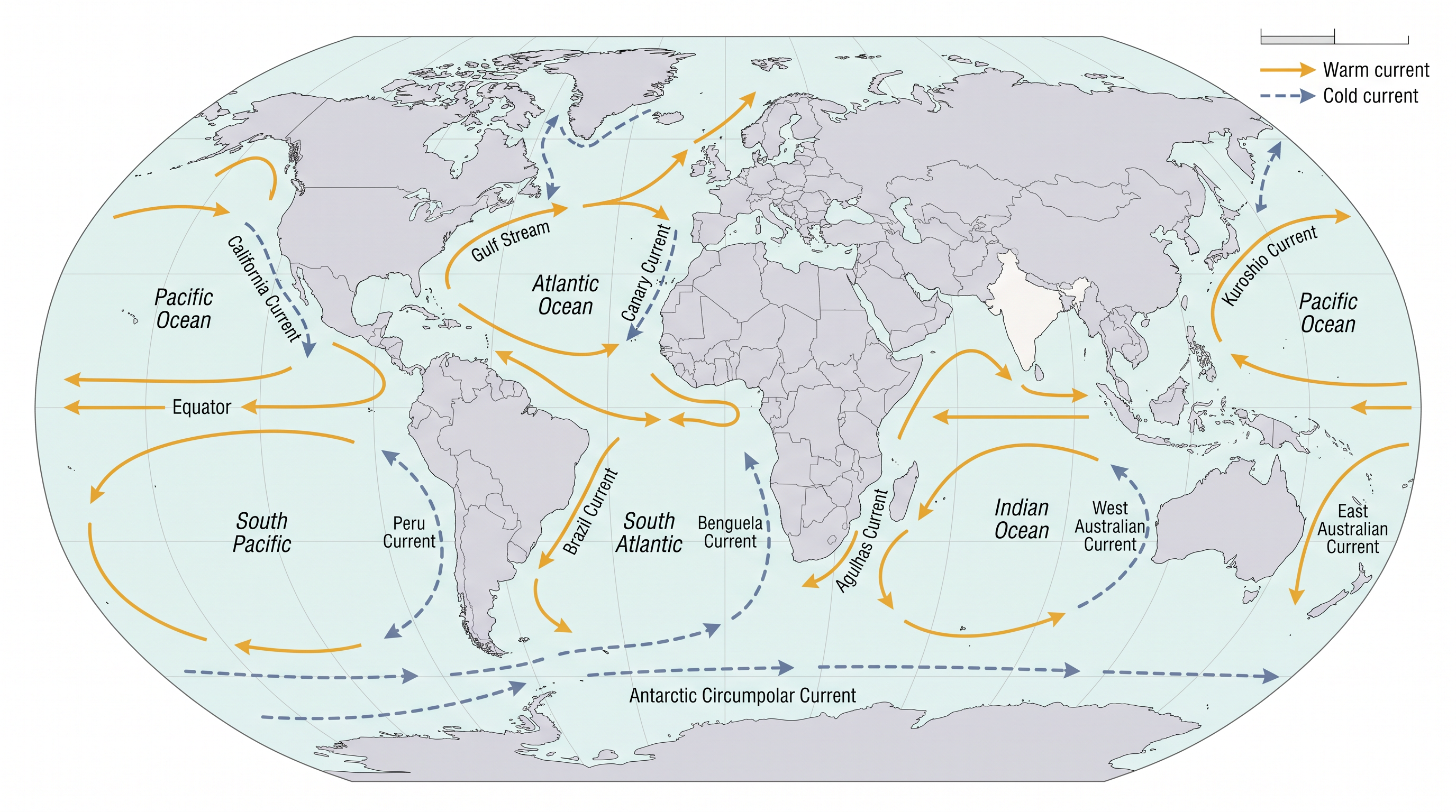
Fig. 13.7 – Major ocean currents of the world.
13.4.3 Effects Of Ocean Currents
Ocean currents reach well beyond the sea itself, shaping climates and livelihoods along the coasts they touch. Their influence on human life is both direct and indirect.
Look first at the west coasts of continents in the tropics and subtropics, away from the equator. These are bordered by cool waters, brought by cold currents. The air above stays cool, so temperatures are relatively low and vary little from day to night or across the seasons. There is often fog — yet, oddly, these coasts are generally arid, with little rain.
The middle and higher latitudes tell a different story. There the west coasts are bordered by warm waters, which give a distinct marine climate — cool summers, mild winters, and a narrow annual range of temperature. Warm currents flowing parallel to the east coasts of continents in the tropics and subtropics have a similar warming effect, producing warm, rainy climates; these coasts sit on the western edge of the great subtropical high-pressure belts.
The richest effect of all appears where currents meet. Where a warm current runs up against a cold one, the mixing of the two waters replenishes the oxygen in the sea and encourages the growth of plankton — the tiny drifting organisms that are the primary food of fish. Wherever the plankton flourish, fish gather, and so the best fishing grounds in the world lie mainly in these mixing zones.
13.5 Summary
- The ocean is always in motion. Its own properties — temperature, salinity and density — together with the pull of the sun and moon and the push of the winds, keep the water moving.
- All that motion is either horizontal (ocean currents and waves) or vertical (tides, and the upwelling and sinking of water).
- A wave carries energy, not water: the water particles only circle in place while the wave form travels on.
- Wind makes and grows waves; a wave slows by friction near the shore and breaks when the water is shallower than half its wavelength.
- Every wave has a crest and trough, and measurable height, amplitude, period, wavelength, speed and frequency.
- A tide is the periodic rise and fall of the sea, once or twice a day, caused mainly by the moon’s gravity, less by the sun’s, together with centrifugal force. Irregular, weather-driven rises are called surges.
- Gravity and centrifugal force raise two tidal bulges on opposite sides of the earth; the tide-generating force is the difference between them.
- The shape of the coast reworks tidal height — wide shelves and funnel-shaped bays raise it, mid-ocean islands lower it — and channelled tides become tidal currents. The Bay of Fundy has the world’s highest tides.
- Tides are grouped by frequency (semi-diurnal, diurnal, mixed) and by sun-moon position (high spring tides in a straight line, low neap tides at right angles).
- The distances to moon and sun matter too: perigee and perihelion raise the range, apogee and aphelion lower it. The falling tide is the ebb, the rising tide the flow or flood.
- Because the earth-moon-sun positions are known exactly, tides can be predicted — useful for navigation, for crossing harbour bars, for flushing estuaries, and for generating tidal power.
- Ocean currents move water in a definite direction. Four primary forces — solar heating, wind, gravity and the Coriolis force — set them going and bend them into circular gyres.
- Density differences add a vertical circulation: cold, salty, dense water sinks and moves equatorward, while warm surface water flows poleward to replace it.
- Currents are classified by depth (surface, about 10 per cent and the upper 400 m; deep water, the other 90 per cent) and by temperature (warm and cold).
- Currents carry heat between latitudes and shape coastal climates: cold currents make west coasts cool, foggy and arid; warm currents bring mild or rainy climates; and where warm and cold currents mix lie the world’s best fishing grounds.
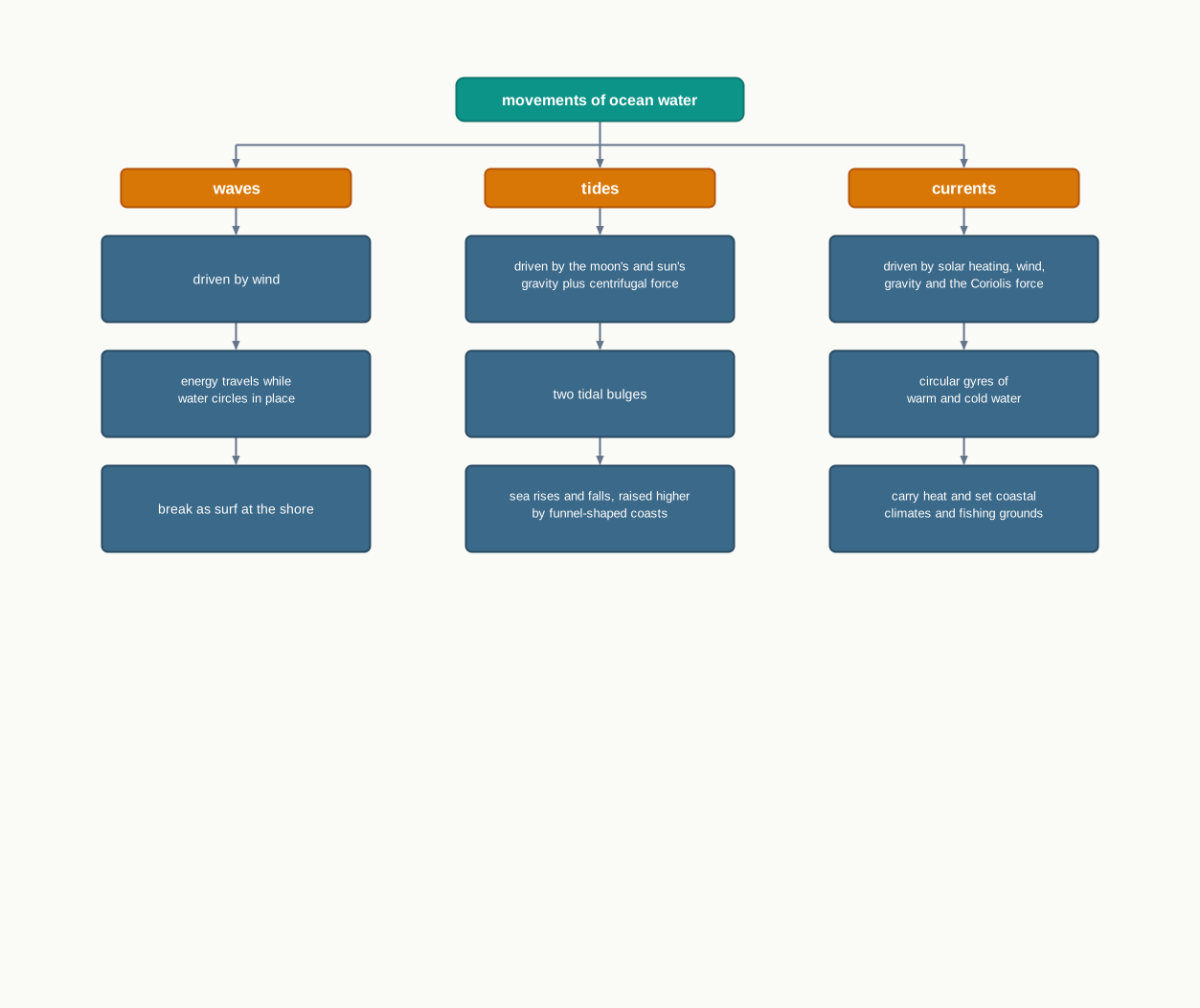
Fig. 13.8 – Summary of ocean water movements.
What This Chapter Cannot Tell You
The two-bulge model explains why tides happen, but not the exact time or height of high tide at any one port — that depends on the local shape of coast and sea floor, which the chapter only sketches.
The current map is a smoothed picture of average surface flow. It cannot show how a current shifts with the seasons, how fast each one runs, or how deep it reaches.
And the chapter takes waves, tides and currents one at a time. It does not show how all three act together on a real coast, on a real day, when a spring tide, a strong wind and a passing current arrive at once.
13.6 NCERT Questions
Upward and downward movement of ocean water is known as the:
- tide
- current
- wave
- none of the above
Spring tides are caused:
- As result of the moon and the sun pulling the earth gravitationally in the same direction.
- As result of the moon and the sun pulling the earth gravitationally in the opposite direction.
- Indention in the coast line.
- None of the above.
The distance between the earth and the moon is minimum when the moon is in:
- Aphelion
- Perigee
- Perihelion
- Apogee
The earth reaches its perihelion in:
- October
- September
- July
- January
What are waves? (30 words)
Where do waves in the ocean get their energy from? (30 words)
What are tides? (30 words)
How are tides caused? (30 words)
How are tides related to navigation? (30 words)
How do currents affect the temperature? How does it affect the temperature of coastal areas in the N. W. Europe? (150 words)
What are the causes of currents? (150 words)
13.7 Check Your Concepts
In Fig. 13.2, the water particles trace small closed circles while the wave itself keeps moving forward. What does this tell you about what a wave actually carries across the ocean?
Distinguish a surge from a tide. Why can a tide be predicted years in advance, while a surge cannot?
Describe, in the correct order, the stages by which a wave forms from a light breeze and finally breaks on a beach.
Using Fig. 13.4, explain why a tidal bulge forms not only on the side of the earth facing the moon but also on the side facing away from it.
Contrast spring tides and neap tides: the positions of the sun and moon in each case, and the effect on the tidal range.
The chapter states that the Bay of Fundy has two high and two low tides in about 24 hours, and that its tide rises about 1,440 cm in about 6 hours. Show the steps to find (a) why a single tide must come in within about 6 hours, and (b) the average rate of rise in centimetres per hour.
Explain why a funnel-shaped bay produces a much higher tide than a straight, open coast.
Fig. 13.7 shows the direction of the world’s major currents. State one important thing about these currents that the map does not tell you.