Chapter 1: Bricks, Beads And Bones: The Harappan Civilisation
In 1875, Alexander Cunningham held a small stone seal in his hand and could not say what it was.
Cunningham was the first Director-General of the Archaeological Survey of India, and is often called the father of Indian archaeology. That year he reported on the ruined mounds at Harappa, in the Punjab. What he found there was a site being carried away. Brick robbers had been quarrying the ancient walls for years, and Cunningham noted that the brick taken from Harappa was enough to lay about 100 miles of the railway line between Lahore and Multan. A city was going out under the rails, cartload by cartload, and nobody thought to stop it, because nobody knew what the city was.
The seal came to him from an Englishman. It carried a line of signs and the figure of an animal. Cunningham noted the object and tried to place it inside the time-frame he trusted — the Early Historic period, the India described by the Chinese Buddhist pilgrims whose travel accounts he used to find sites worth digging. The seal would not go in. Like most scholars of his day, he believed that Indian history began with the first cities of the Ganga valley.
He was holding evidence of a civilisation far older than anything he was searching for. He had the object. What he did not have was a frame of reference to put it in.
This chapter is about that frame — and about how it was slowly built.
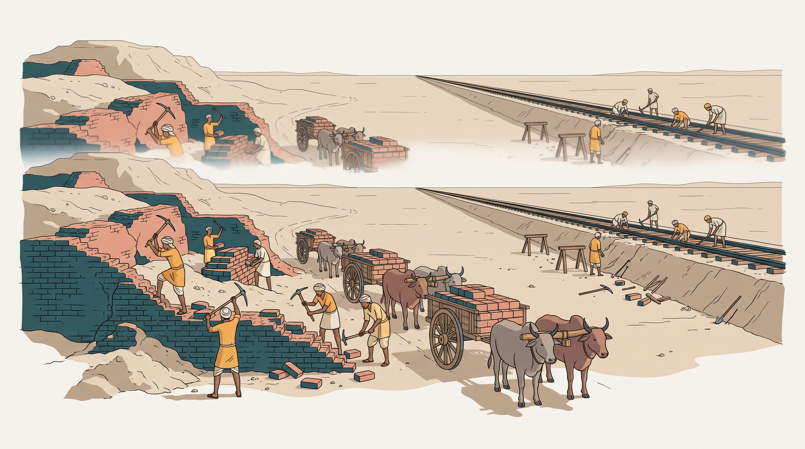
Fig. 1.0 – Brick robbers at Harappa.
1.1 Beginnings
An Object That Cannot Be Read
Look closely at the object in Fig. 1.1. It is a Harappan seal, and it is possibly the most distinctive artefact the Harappan, or Indus valley, civilisation left behind. It is made of a stone called steatite. Seals like this one often carry an animal motif and signs from a script that remains undeciphered.
That last word matters. Nobody today can read Harappan writing. Most ancient civilisations can be approached partly through their texts. This one cannot.
And yet we know a great deal about the people who lived in this region. We know what they ate, what they built, what they wore and where they got their raw materials. We know it from what they left behind — their houses, pots, ornaments, tools and seals. This is archaeological evidence: the material things a society leaves in the ground, from which the past is reconstructed. Archaeology is the study of that evidence.
So this chapter asks two questions side by side. What do we know about the Harappan civilisation, and how do we know it? You will see how archaeological material is interpreted, and how interpretations sometimes change — an object that meant nothing to one generation of scholars meant a great deal to the next. You will also meet the honest limits. Some aspects of this civilisation are as yet unknown, and may even remain so.
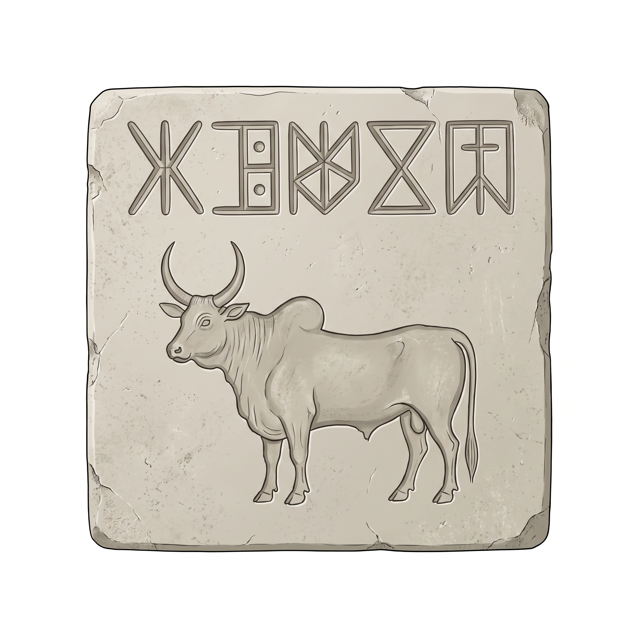
Fig. 1.1 – A Harappan steatite seal.
Terminologies, Places And Time
The Harappan Civilisation is also known as the Indus Valley Civilisation. The term Harappa is derived from the place where the civilisation was identified.
The total time span of the civilisation ranges from 6000 BCE to 1300 BCE. That span is divided into three phases. The early phase, termed as Early Harappan (6000 BCE-2600 BCE), is a formative phase of the civilisation. The urban phase, termed as Mature Harappan (2600 BCE-1900 BCE), is the most prosperous phase — this is the phase of the cities. The decline of the civilisation starts around 1900 BCE, and this decadent phase (1900 BCE-1300 BCE) is termed as Late Harappan.
Keep the middle phase firmly in mind. When this chapter speaks of Harappan cities, planned streets and standardised bricks, it is almost always speaking of the Mature Harappan phase — a window of about seven hundred years inside a much longer story.
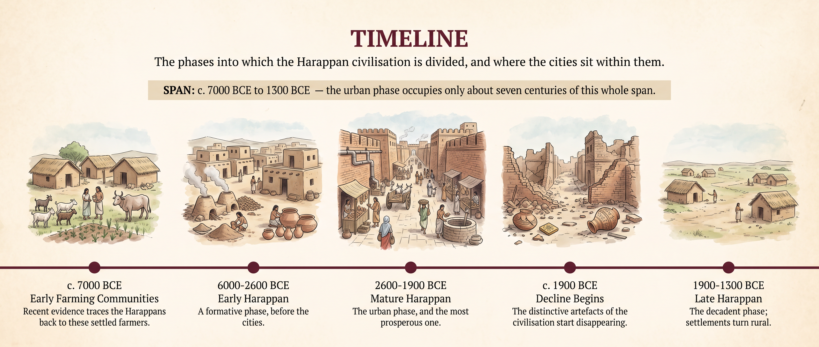
Fig. 1.2 – The Three Phases Of A Long Civilisation.
How Far The Harappans Reached
The Harappans can be recognised by a distinctive set of things: their pottery, their bricks (baked and unbaked), their seals, their weights, their beads, and their copper and bronze articles. Where that package of objects turns up in the ground, archaeologists identify a Harappan settlement.
The package has been found across an enormous stretch of land. It appears as far apart as Afghanistan, Baluchistan, and the Sind and Punjab provinces of Pakistan, and in the Indian States of Jammu and Kashmir, Punjab, Haryana, Rajasthan, Uttar Pradesh, Gujarat and Maharashtra. Map 1 shows some of the important Mature Harappan sites within that spread.
Notice at once that these are the borders of today, not of the past. The Harappans knew nothing of Pakistan, Afghanistan or the Indian States. Modern names are used here only because they are the names we have for the land.
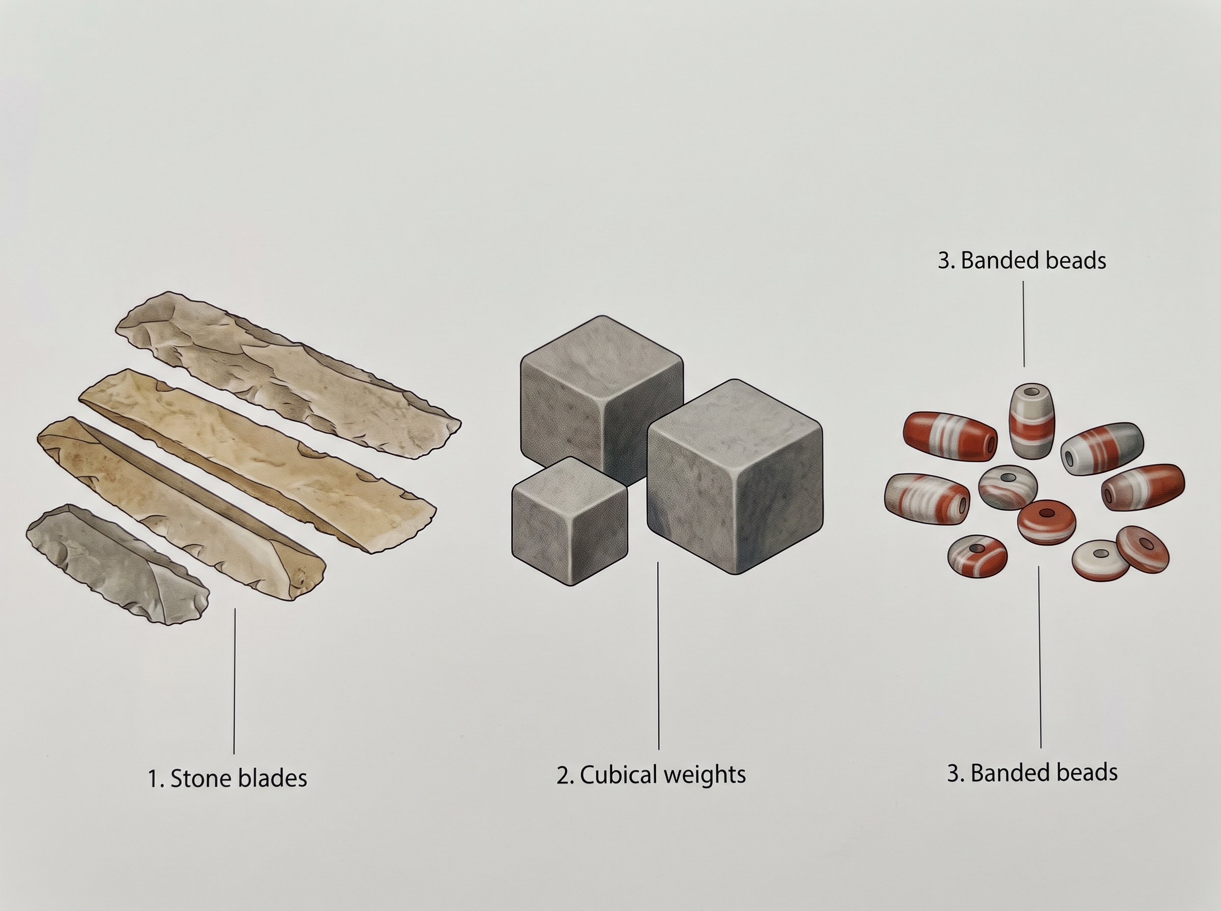
Fig. 1.3 – Harappan beads, weights and blades.
Map
Map 1 Caption: Some important Mature Harappan sites. Sketch map not to scale. Brief: Sketch map of the north-western subcontinent showing the Indus and its tributaries (Jhelum, Chenab, Ravi, Sutlej), the Ganga, Yamuna, Chambal, Sabarmati, Mahi and Narmada, and the Arabian Sea. Mark Manda, Harappa, Rakhigarhi, Banawali, Mitathal, Kalibangan, Ganweriwala, Mohenjodaro, Kot Diji, Amri, Chanhudaro, Balakot, Sutkagendor, Dholavira, Lothal, Nageshwar and Rangpur. Show the full extent of India as officially defined. Note on the map that the boundaries shown are modern, given only for orientation; the Harappan world had no such borders.
Two Thousand Sites, Five Cities
So far, more than 2000 Harappan archaeological sites have been discovered in the Indian sub-continent. Most of them are located between the Indus and the Saraswati river basins. Nearly two-thirds of these settlements lie in the Saraswati basin, which suggests the immense importance of that river system for the Harappan Civilisation.
Among these sites, five major cities have been identified: Rakhigarhi, Mohenjodaro, Harappa, Dholavira and Ganweriwala. The remaining sites come under different categories — regional centres, agricultural villages, ports and manufacturing centres.
Those few lines tell you something important before you read another page. This was not a civilisation of cities alone. For every city there were hundreds of villages growing food, coastal settlements handling shell, and workshop towns making beads. The cities sat at the top of a far larger web of settlements, and they depended on it.
What Came Before The Cities
The cities did not appear out of nowhere. There were several archaeological cultures in the region prior to the Mature Harappan. These cultures were associated with distinctive pottery, evidence of agriculture and pastoralism, and some crafts.
But their settlements were generally small, and there were virtually no large buildings. No platforms, no massive walls, no warehouses, no drains running down planned streets. People farmed, kept animals and made things — but not on the scale the Mature Harappan phase would reach.
Recent archaeological evidence also indicates the emergence of Harappan culture from early farming communities dated around 7000 BCE. The roots, in other words, go back far deeper than the cities themselves.
This shapes how you should think about the urban phase. The Mature Harappan was a consequent result of the gradual transformation and internal development of the civilisation during the Early Harappan phase. It grew from within. It was not carried in from outside, and it was not a sudden invention. It was the outcome of thousands of years of people farming, herding and building in the same landscape.
1.2 Subsistence Strategies
The Same Land, Twice Settled
Put Map 1 and Map 2 side by side. Map 1 shows some important Mature Harappan sites; Map 2 shows the areas of Early Harappan occupation. Look at them together and you will notice that the Mature Harappan culture developed in some of the areas occupied by the Early Harappan cultures.
That overlap is not a coincidence. These cultures also shared certain common elements, including subsistence strategies — the ways in which a people feed themselves. What people grew, herded, hunted and fished did not change overnight when the cities appeared. The city was new; the food system underneath it was inherited.
Map
Map 2 Caption: Areas of Early Harappan occupation. Sketch map not to scale. Brief: Sketch map of the north-western subcontinent showing the Indus and the Arabian Sea, with dense dot scatters marking areas of Early Harappan settlement; label AMRI-NAL, DAMB SADAAT, KOT DIJI and SISWAL. Show the full extent of India as officially defined. Note on the map that these are settlement areas of the Early Harappan period; boundaries shown are modern and given only for orientation.
What The Harappans Ate
The Harappans ate a wide range of plant and animal products, including fish. That is the conclusion. The interesting part is how anyone can possibly know it.
Archaeologists have been able to reconstruct dietary practices from finds of charred grains and seeds. Grain that is burnt — spilled into a hearth, caught in a fire, scorched while being parched — does not rot away. It survives in the soil as a hard blackened husk, and it can still be identified thousands of years later. These remains are studied by archaeo-botanists, who are specialists in ancient plant remains.
Grains found at Harappan sites include wheat, barley, lentil, chickpea and sesame. Millets are found from sites in Gujarat. Finds of rice are relatively rare. Notice the geography hiding inside that list. The crops are not identical everywhere, and the Gujarat sites show a different pattern from the northern ones.
Animal bones found at Harappan sites include those of cattle, sheep, goat, buffalo and pig. Studies done by archaeo-zoologists or zoo-archaeologists — specialists in ancient animal remains — indicate that these animals were domesticated. A domesticated animal is one bred and kept by people rather than hunted, and its bones can be told apart from those of its wild relatives.
Bones of wild species such as boar, deer and gharial are also found. The gharial is a long-snouted, fish-eating crocodile of the rivers of the plains. Its bones at a settlement show that the animal reached the settlement. They do not show who caught it. We do not know whether the Harappans hunted these animals themselves or obtained meat from other hunting communities. Bones of fish and fowl are also found.
Hold on to that uncertainty. It is a small one, but it has exactly the shape of the larger problem running through this chapter. A bone in the ground proves that an animal was eaten. It does not name the hand that killed it.
1.2.1 Agricultural Technologies
While the prevalence of agriculture is indicated by finds of grain, it is more difficult to reconstruct actual agricultural practices. Grain in the ground proves that crops were grown. It does not show you the field, the tool, or the working year.
So the questions come quickly, and most of them stay open. Were seeds broadcast — that is, scattered by hand — on ploughed lands? We cannot say for certain.
Ploughing: An Argument Built From Models
Representations on seals and terracotta sculpture indicate that the bull was known, and archaeologists extrapolate from this that oxen were used for ploughing. Read that sentence slowly, because there is a leap inside it. What survives is an image of a bull. What is claimed is a farming practice. The link between the two is an inference, not an observation.
The inference does not stand alone. Terracotta models of the plough have been found at sites in Cholistan, a dry region of present-day Pakistan, and at Banawali (Haryana). A model plough is a strong clue, because people do not model a tool they have never seen.
Stronger still, archaeologists have found evidence of a ploughed field at Kalibangan (Rajasthan), associated with Early Harappan levels — that is, found in a layer of soil laid down in the Early Harappan phase, which is how such a find is dated. (You will meet layers and stratigraphy properly later in this chapter.) The field had two sets of furrows at right angles to each other, suggesting that two different crops were grown together.
That is a remarkable survival. Not a tool, and not a picture of a tool, but the marks a tool left in the earth. And it carries an idea with it. Two crops in one field, in furrows crossing at right angles, is a deliberate decision — plants that ripen at different times, or draw differently on the soil, grown in the same ground.
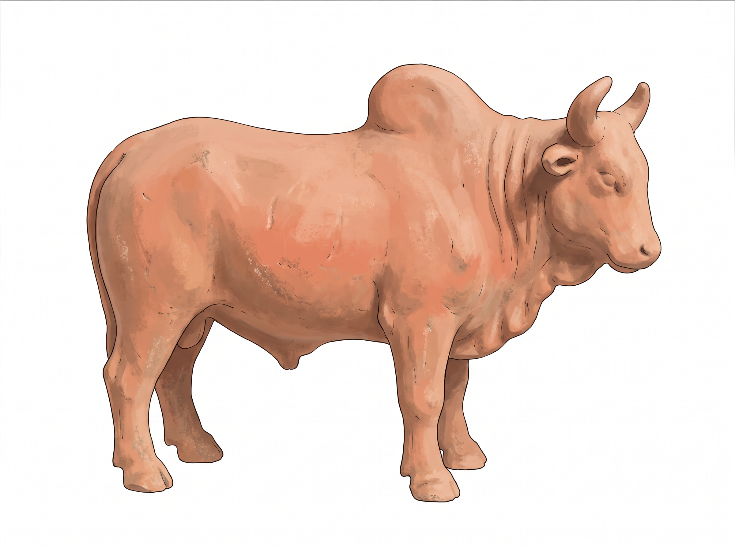
Fig. 1.4 – A terracotta humped bull.
Harvesting: A Question Without An Answer
Archaeologists have also tried to identify the tools used for harvesting. Did the Harappans use stone blades set in wooden handles, or did they use metal tools?
We do not know, and the reason is worth pausing over. Wooden handles rot. Metal was valuable and was recycled rather than discarded. What survives is therefore a poor sample of what was actually used, and the question stays open.
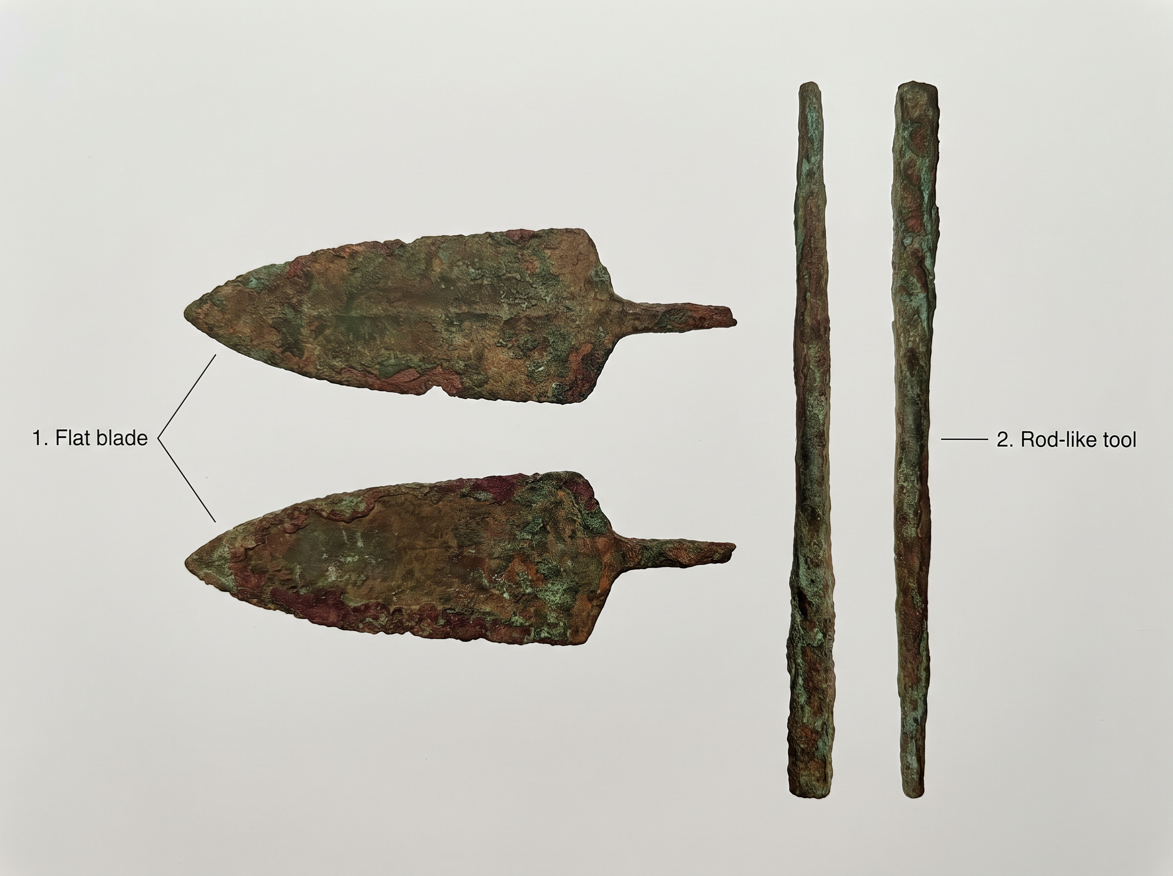
Fig. 1.5 – Harappan copper tools.
Watering A Dry Land
Most Harappan sites are located in semi-arid lands — country that receives little rain, dry but not quite desert, where a crop cannot be relied upon from rainfall alone. In such land, irrigation, the artificial supply of water to fields, was probably required for agriculture.
Where is the evidence? Traces of canals have been found at the Harappan site of Shortughai in Afghanistan, but not in Punjab or Sind. That absence is a puzzle rather than a proof. It is possible that ancient canals silted up long ago, filling with mud until there was nothing left to find.
It is also likely that water drawn from wells was used for irrigation. Besides, water reservoirs found in Dholavira (Gujarat) may have been used to store water for agriculture. Look at Fig. 1.6 and note the masonry work — cut stone, fitted and stepped, in a tank built to hold water in one of the driest corners of the Harappan world.
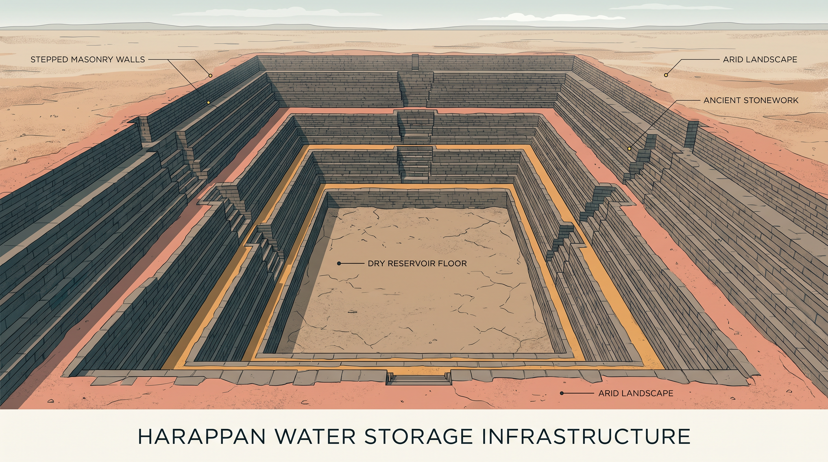
Fig. 1.6 – The stone-lined reservoir at Dholavira.
Grinding, Cooking, And The Objects Left Behind
Processing of food required grinding equipment as well as vessels for mixing, blending and cooking. These were made of stone, metal and terracotta. An artefact is any object made or used by people and recovered by archaeologists — a quern, a pot, a bead, a blade.
The extract below is from one of the earliest reports on excavations at Mohenjodaro, the best-known Harappan site. Its author, Ernest Mackay, was one of the excavators. Watch what he actually does. He describes the stones he has dug out of the ground, and then explains what they were for by comparing them with the grinding stones his own workmen and his cook used every day.
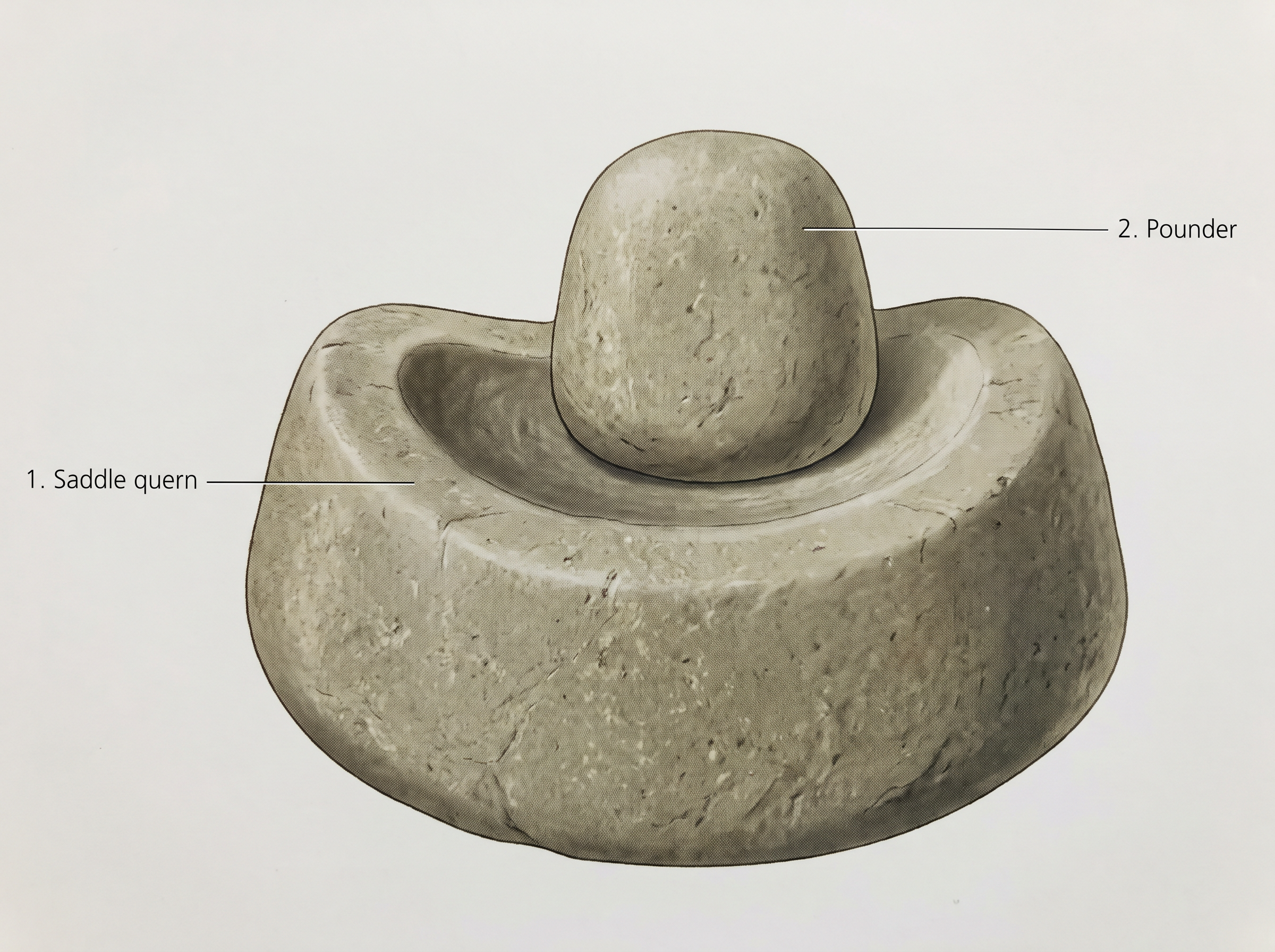
Fig. 1.7 – A saddle quern and pounder.
Notice how much of Mackay’s confidence is borrowed from the present. The wear on the stones is evidence, and he can see it: hard usage, convex bases, a cavity pounded into the lower stone. But the step from ‘a cavity was pounded into this stone’ to ‘this was used for pounding herbs and spices for making curries’ is not something the stone tells him. It is something the kitchen next door tells him.
This strategy is called analogy — reasoning from the familiar present to the unfamiliar past. It is one of the archaeologist’s most useful tools, and one of the most dangerous. It works well for a quern, because grinding grain between two stones has changed very little in five thousand years. It works far less well, as you will see later in this chapter, when the object is a figurine or a symbol, and the present-day thing it resembles carries meanings the Harappans may never have had.
1.3 Mohanjodaro — A Planned Urban Centre
Perhaps the most unique feature of the Harappan civilisation was the development of urban centres. Villages the region already had, for thousands of years. Cities it did not. So it is worth looking at one such centre, Mohenjodaro, more closely, and asking what a Harappan city actually was.
One point of history before we walk into it. Although Mohenjodaro is the most well-known site, the first site to be discovered was Harappa.
Why Mohenjodaro And Not Harappa
Harappa gave the civilisation its name, but it cannot give us its clearest picture, because Harappa was badly destroyed by brick robbers. As early as 1875, Alexander Cunningham, the first Director-General of the Archaeological Survey of India (ASI) — often called the father of Indian archaeology — noted that the amount of brick taken from the ancient site was enough to lay bricks for about 100 miles of the railway line between Lahore and Multan. Many of the ancient structures at the site were damaged in this way. In contrast, Mohenjodaro was far better preserved.
There is a hard lesson buried in that sentence, and it is a lesson about evidence rather than about bricks. Harappan brick was good brick, still solid after four thousand years, and it was free for the taking. Every cartload that went under the railway line took a wall, a room, a street with it. What an archaeologist can know about Harappa is limited forever by what was carried away before anybody knew it mattered.
The City In Two Parts
The settlement is divided into two sections. One is smaller but higher; the other is much larger but lower. Archaeologists designate these as the Citadel and the Lower Town respectively.
The Citadel owes its height to the fact that buildings there were constructed on mud brick platforms. It was walled, which meant that it was physically separated from the Lower Town. The Lower Town was also walled, and several buildings within it were built on platforms, which served as foundations.
Notice what is being said and what is not. The Citadel is not high because it stands on a hill. It is high because people raised it — they built a mud brick platform and put buildings on top of it. The height of the Citadel is not a fact of geography. It is a fact of labour.
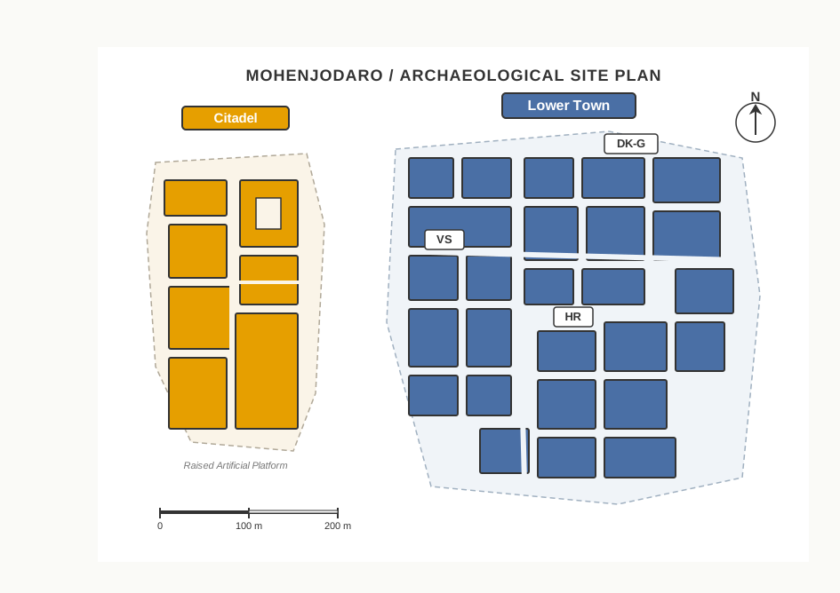
Fig. 1.8 – Layout of Mohenjodaro.
The Arithmetic Of A Platform
The platforms were not a detail of construction. They were the single largest thing the Harappans built, and the cost of them can be calculated.
It has been calculated that if one labourer moved roughly a cubic metre of earth daily, just to put the foundations in place it would have required four million person-days. A person-day is one person’s work for one day, and it is the unit in which large building projects are measured even now.
Work through what that number means. If one labourer shifts \(1\ \text{m}^3\) of earth in a day, then
\[\text{earth moved} = 4{,}000{,}000\ \text{person-days} \times 1\ \frac{\text{m}^3}{\text{person-day}} = 4{,}000{,}000\ \text{m}^3\]
Four million cubic metres of earth, carried by hand. And spread the labour out: if a thousand people worked at it every single day, the foundations alone would take
\[\frac{4{,}000{,}000\ \text{person-days}}{1{,}000\ \text{persons}} = 4{,}000\ \text{days}\]
which is roughly eleven years of unbroken work, before a single house is built on top.
This is what the phrase ‘mobilising labour on a very large scale’ actually means. Thousands of people had to be gathered, told where to dig, kept fed while they dug, and kept at it for years. Somebody decided this was worth doing. Hold on to that thought — we return to it when we ask, in section 1.8, who was giving the orders.
Planned First, Built Afterwards
Consider something else. Once the platforms were in place, all building activity within the city was restricted to a fixed area on the platforms. You cannot raise a platform to fit a house that already exists. The platform comes first, and it fixes for good where building can happen.
So it seems that the settlement was first planned and then implemented accordingly. That is the central claim of this section, and it is built from physical evidence, not from any text.
Other signs of planning include the bricks. Whether sun-dried or baked, they were of a standardised ratio, where the length and breadth were four times and twice the height respectively — a ratio of 4:2:1. Such bricks were used at all Harappan settlements.
Variations On The Plan
Do not let Mohenjodaro become the whole picture. While most Harappan settlements have a small high western part and a larger lower eastern section, there are variations.
At sites such as Dholavira and Lothal (Gujarat), the entire settlement was fortified, and sections within the town were also separated by walls. The Citadel within Lothal was not walled off, but was built at a height.
In other words, the idea of dividing and enclosing a settlement was shared, but the way of doing it was not identical everywhere. Uniformity in Harappan cities is real, and it is striking — but it is not mechanical.
1.3.1 Laying Out Drains
One of the most distinctive features of Harappan cities was the carefully planned drainage system.
Look again at the plan of the Lower Town in Fig. 1.8. You will notice that roads and streets were laid out along an approximate ‘grid’ pattern, intersecting at right angles. Streets crossing like that do not happen by themselves. They happen when someone lays them out.
It seems that streets with drains were laid out first, and then houses were built along them. The order matters enormously. It means the public system came before the private buildings, and the buildings had to fit themselves to it.
And there is a neat consequence, which you can work out for yourself. If domestic waste water had to flow into the street drains, every house needed to have at least one wall along a street. A house entirely surrounded by other houses could not drain. So the drain quietly decided the shape of the neighbourhood.
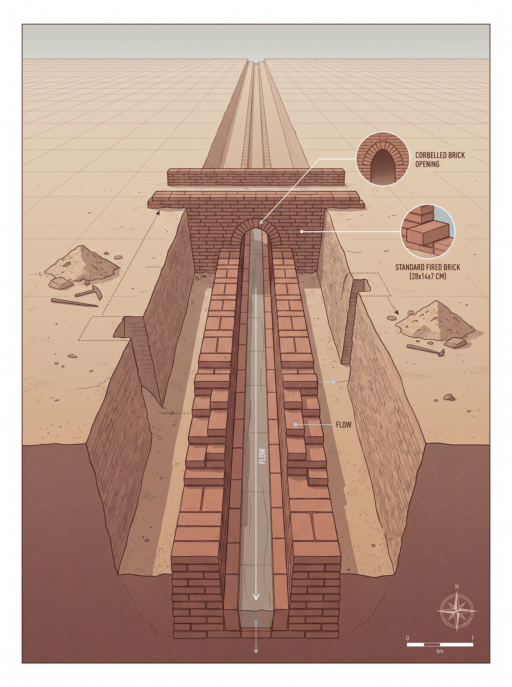
Fig. 1.9 – A street drain in Mohenjodaro.
1.3.2 Domestic Architecture
The Lower Town at Mohenjodaro provides examples of residential buildings — ordinary houses, where ordinary people lived.
Many were centred on a courtyard, with rooms on all sides. The courtyard was probably the centre of activities such as cooking and weaving, particularly during hot and dry weather. Anyone who has worked in an open verandah in May will understand the reasoning: an open, shaded, walled space is cooler than a closed room, and safe from the street.
What is also interesting is an apparent concern for privacy. There are no windows in the walls along the ground level. Besides, the main entrance does not give a direct view of the interior or the courtyard. The house turns its back on the street. What happened inside was not for passers-by to see.
Water, Waste And Stairs
Every house had its own bathroom paved with bricks, with drains connected through the wall to the street drains. Read that once more. Not a shared latrine at the end of the lane — a bathroom in the house, and a drain from that bathroom into the public system.
Some houses have remains of staircases to reach a second storey or the roof. Many houses had wells, often in a room that could be reached from the outside and perhaps used by passers-by. Scholars have estimated that the total number of wells in Mohenjodaro was about 700.
Seven hundred wells is a great many for one city. It suggests that water was not something you queued for at a single public tank. It was close at hand, in your own house or the next one — and some of those wells, judging by the rooms that opened on to the street, were shared with strangers.
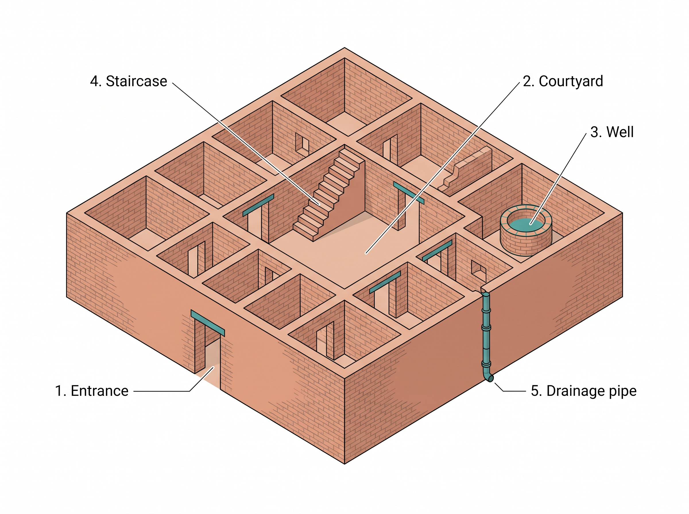
Fig. 1.10 – Isometric drawing of a Mohenjodaro house.
An Excavator On The Drains
The next extract is again from Ernest Mackay, writing in 1948, some years after the report you read in section 1.2. He is describing the drainage system he uncovered at Mohenjodaro, and he is plainly impressed by it. Watch how his evidence is not only the drains themselves but the rubbish beside them.
Drainage systems were not unique to the larger cities, but were found in smaller settlements as well. At Lothal, for example, while houses were built of mud bricks, drains were made of burnt bricks. Even a small town spent its best material on its drains.
Now look at the last sentence of the extract again, because it is the most human thing in this chapter so far. Little heaps of sand and muck were found lying beside the channels. Somebody opened a drain, scraped out the sludge, piled it on the street — and did not come back for it. A system was designed to be cleaned. The cleaning was done by people, and people are inconsistent. The Harappan drains were maintained; they were not maintained perfectly.
1.3.3 The Citadel
It is on the Citadel that we find evidence of structures that were probably used for special public purposes. Two of them stand out.
The first is the warehouse — a massive structure of which only the lower brick portions remain, while the upper portions, probably of wood, decayed long ago. That is a reminder to keep with you: what survives is chosen for us by the material. Brick lasts; timber does not. Half of that building is missing, and it is missing because of what it was made of, not because of what it was.
The Great Bath
The second is the Great Bath. It was a large rectangular tank in a courtyard surrounded by a corridor on all four sides. There were two flights of steps on the north and south leading into the tank, which was made watertight by setting bricks on edge and using a mortar of gypsum.
Consider the trouble taken there. Bricks set on edge, packed with gypsum mortar — this is deliberate waterproofing, of the kind you would only bother with if the tank had to hold water and hold it well.
There were rooms on three sides, in one of which was a large well. Water from the tank flowed into a huge drain, so the tank could be emptied as well as filled. Across a lane to the north lay a smaller building with eight bathrooms, four on each side of a corridor, with drains from each bathroom connecting to a drain that ran along the corridor.
So what was it for? The uniqueness of the structure, as well as the context in which it was found — the Citadel, with several distinctive buildings — has led scholars to suggest that it was meant for some kind of a special ritual bath.
Notice the two words doing the work in that sentence: uniqueness and context. Nothing in the tank itself says ‘ritual’. It is a watertight tank with steps. The suggestion comes from the fact that there is nothing else like it, and that it sits in the walled, raised, public part of the city rather than in a house. Change the context and you would change the interpretation. The Great Bath remains, as you will see in section 1.11, one of the open questions of Harappan archaeology.
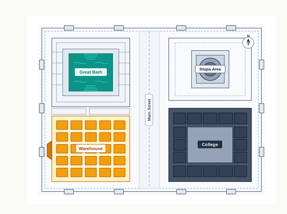
Fig. 1.11 – Plan of the Mohenjodaro Citadel.
1.4 Tracking Social Differences
Every society you will study in this book had people who had more and people who had less. The question is how you would find that out about a society that left no readable writing, no law code, no tax record and no complaint.
Archaeologists generally use certain strategies to find out whether there were social or economic differences amongst people living within a particular culture. Two of them are used in this section: they look at how the dead were buried, and they look at who owned the rare and costly things.
1.4.1 Burials
The first strategy is to study burials. The reasoning behind it is simple. Burial is one of the few moments when a society deliberately arranges a person, and it can be a moment when it displays what that person was worth to it.
You are probably familiar with the massive pyramids of Egypt, some of which were contemporaneous with the Harappan civilisation — standing in the world at the same time as Mohenjodaro and Harappa. Many of these pyramids were royal burials, where enormous quantities of wealth was buried. A society that buries a mountain of gold with one man is telling you, unmistakably, what it thought of that man and of everyone else.
What Harappan Graves Actually Contain
Now set that beside the Harappan evidence, and notice how much quieter it is.
At burials in Harappan sites the dead were generally laid in pits. Sometimes, there were differences in the way the burial pit was made — in some instances, the hollowed-out spaces were lined with bricks. A brick-lined grave took more work and more material than a plain pit. Could these variations be an indication of social differences? We are not sure. The book says so plainly, and you should not be tempted past it.
Some graves contain pottery and ornaments, perhaps indicating a belief that these could be used in the afterlife. Jewellery has been found in burials of both men and women — which is itself worth noting, since it means ornament was not the mark of one sex alone.
In fact, in the excavations at the cemetery in Harappa in the mid-1980s, an ornament consisting of three shell rings, a jasper (a kind of semi-precious stone) bead and hundreds of micro beads was found near the skull of a male. In some instances the dead were buried with copper mirrors.
But on the whole, it appears that the Harappans did not believe in burying precious things with the dead.
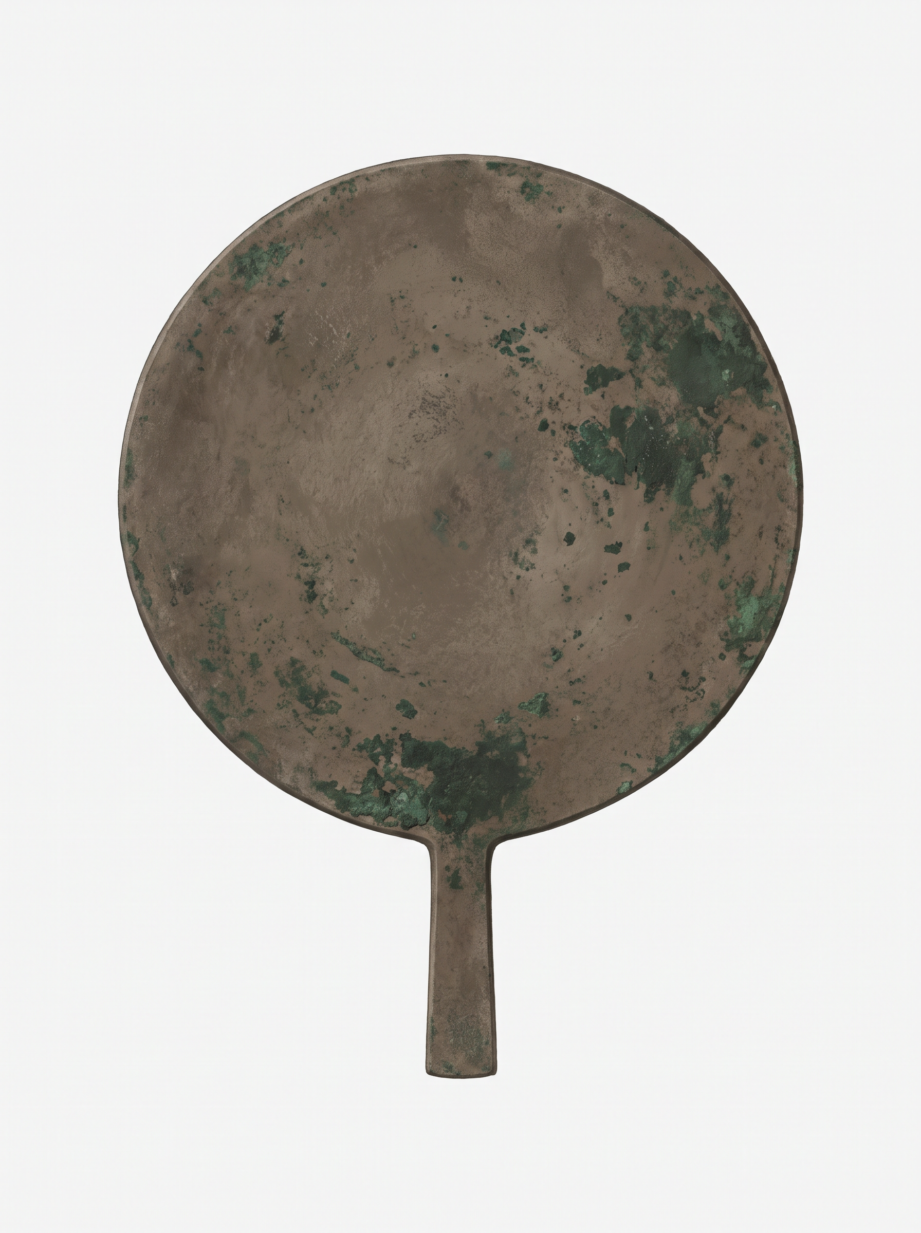
Fig. 1.12 – A Harappan copper mirror.
1.4.2 Looking For ‘Luxuries’
The second strategy is to identify social differences by studying artefacts, which archaeologists broadly classify as utilitarian and luxuries.
The first category, utilitarian objects, includes objects of daily use made fairly easily out of ordinary materials such as stone or clay. These include querns, pottery, needles, flesh-rubbers (body scrubbers), and so on. They are usually found distributed throughout settlements — everywhere, in other words, because everyone needed them.
Archaeologists assume objects were luxuries if they are rare, or made from costly, non-local materials, or made with complicated technologies. Thus, little pots of faience — a material made of ground sand or silica mixed with colour and a gum and then fired — were probably considered precious because they were difficult to make. Faience is not dug out of the ground. It is manufactured, in a workshop, by someone who knows how, and that knowledge is itself scarce.
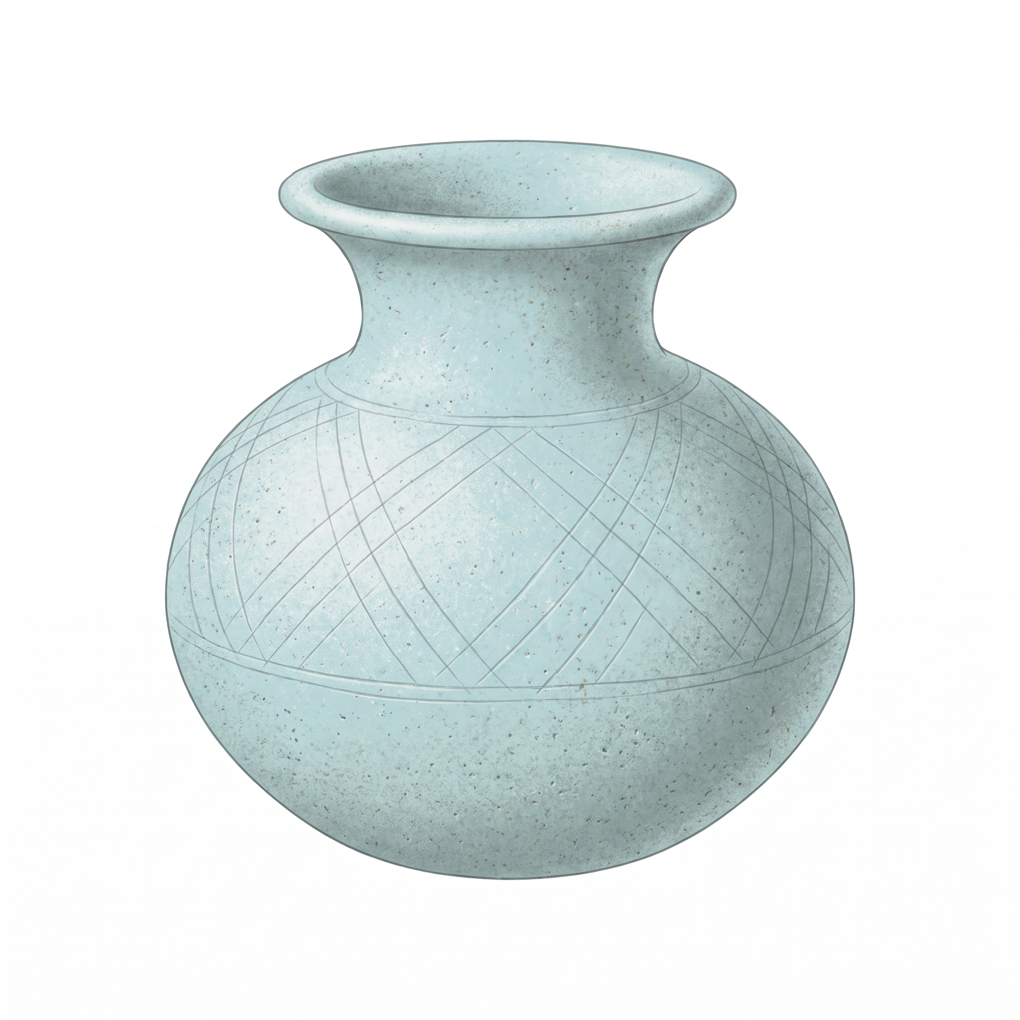
Fig. 1.13 – A miniature faience pot.
Notice that the classification does not rest on beauty or on the archaeologist’s taste. It rests on three testable things: how rare the object is, how far its material had to travel, and how hard it was to make.
Where The Classification Breaks Down
The situation becomes more complicated when we find what seem to be articles of daily use, such as spindle whorls — the small weights used in spinning thread — made of rare materials such as faience. Do we classify these as utilitarian or luxuries?
The object does an everyday job. The material is precious and difficult. So the two categories, which looked so clean a paragraph ago, cut straight through the same object.
Keep that discomfort. It is not a flaw in the evidence; it is a flaw in the boxes we brought to the evidence. Real societies do not sort their possessions to suit an archaeologist’s categories. A spinner may want a fine whorl for the same reason a person today may want a good pen for ordinary writing.
The Geography Of Precious Things
Now change the question. Instead of asking what an object is, ask where it is found — and the picture sharpens at once.
If we study the distribution of such artefacts, we find that rare objects made of valuable materials are generally concentrated in large settlements like Mohenjodaro and Harappa, and are rarely found in the smaller settlements. For example, miniature pots of faience, perhaps used as perfume bottles, are found mostly in Mohenjodaro and Harappa, and there are none from small settlements like Kalibangan.
That is a real, countable difference — not between one grave and another, but between one kind of settlement and another. The precious things gathered in the big cities.
Gold too was rare, and, as at present, probably precious. And all the gold jewellery found at Harappan sites was recovered from hoards. A hoard is a collection of objects kept carefully by people, often inside containers such as pots. Hoards can be of jewellery, or of metal objects saved for reuse by metalworkers. If for some reason the original owners do not retrieve them, they remain where they are left till some archaeologist finds them.
Think about what that implies. Not a single piece of Harappan gold jewellery has come to us because somebody displayed it, wore it to the grave or left it lying in a house. Every piece we have was hidden — put away by someone who meant to come back for it, and did not. Our knowledge of Harappan gold is built entirely out of other people’s misfortune.
1.5 Finding Out About Craft Production
A Small Town With A Single Purpose
Locate Chanhudaro on Map 1. It is a tiny settlement — less than 7 hectares — as compared to Mohenjodaro, which covers 125 hectares. A hectare is 10,000 square metres, a square roughly 100 metres by 100 metres, so you can see the scale of the difference at once:
\[\frac{125\ \text{hectares}}{7\ \text{hectares}} \approx 18\]
Mohenjodaro was something like eighteen times the size of Chanhudaro. And yet Chanhudaro matters enormously, because it was almost exclusively devoted to craft production — bead-making, shell-cutting, metal-working, seal-making and weight-making.
Think about what a place like that implies. A settlement of a few hundred people who make things and do not, apparently, do much else must eat food grown by somebody else, in some other place. Chanhudaro could only exist inside a system — a system that moved grain in and finished goods out.
The Extraordinary Range Of A Bead
The variety of materials used to make beads is remarkable. Stones like carnelian — of a beautiful red colour — jasper, crystal, quartz and steatite. Metals like copper, bronze and gold. And shell, faience, and terracotta or burnt clay.
The craftsmanship goes further than the list of materials. Some beads were made of two or more stones, cemented together. Some were of stone with gold caps. The shapes were numerous — disc-shaped, cylindrical, spherical, barrel-shaped, segmented. Some were decorated by incising or painting, and some had designs etched onto them.
That is not the output of a person making a few ornaments at home in the evening. It is museum-quality output by specialists, with recipes, tools and long training behind them.
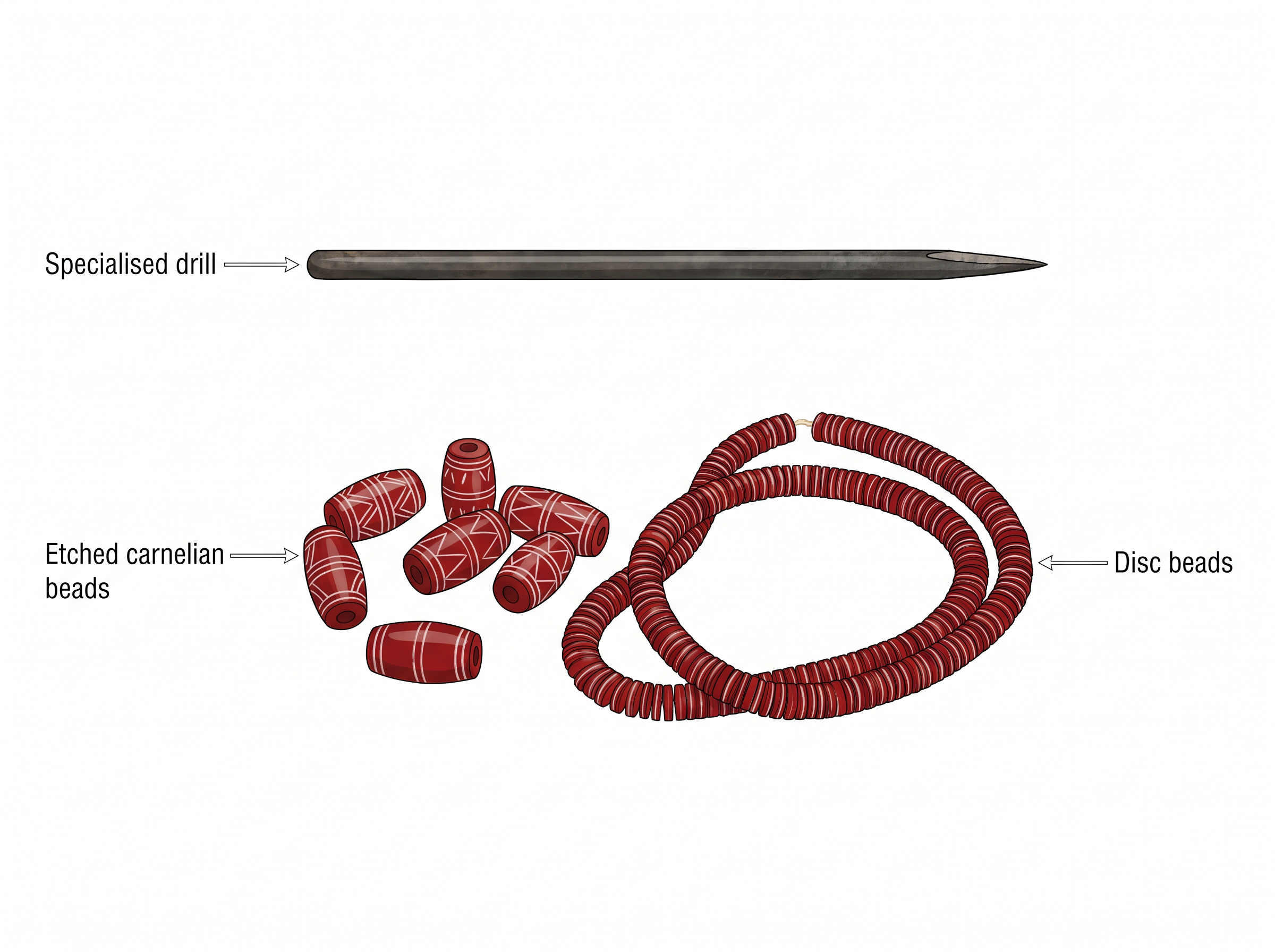
Fig. 1.14 – A bead-maker’s drill and finished beads.
Technique Follows Material
Techniques for making beads differed according to the material.
Steatite, a very soft stone, was easily worked. Some beads were moulded out of a paste made with steatite powder. That is a striking idea: the stone was ground up and remade as a paste, so it could be shaped rather than merely cut. This permitted making a variety of shapes, unlike the geometrical forms made out of harder stones — a hard stone can only be given the shapes a chisel and a grinder can reach.
And even here the evidence runs out. How the steatite micro bead was made remains a puzzle for archaeologists studying ancient technology. Some of these beads are so minute that no one has yet reconstructed how a Harappan craftsperson drilled them. The Harappans knew something that we, with all our instruments, have not worked out.
The Making Of A Carnelian Bead
Carnelian is the red stone in Harappan jewellery, and its red is not natural. Archaeologists’ experiments have revealed that the red colour of carnelian was obtained by firing the yellowish raw material and the beads at various stages of production. The stone comes out of the ground a dull yellow. Heat turns it red.
Notice how that was discovered. Not from a text, and not from a picture — from experiment. Archaeologists took the raw material, fired it, and watched the colour change. This is a whole method of the discipline: when the past will not tell you how something was done, try to do it yourself.
The rest of the process is reconstructed from the waste and the tools. Nodules — lumps of raw stone as they come from the ground — were chipped into rough shapes, and then finely flaked into the final form. Grinding, polishing and drilling completed the process. Specialised drills have been found at Chanhudaro, Lothal and more recently at Dholavira.
Where Shells Were Cut
If you locate Nageshwar and Balakot on Map 1, you will notice that both settlements are near the coast. That is not an accident. Shell comes from the sea, and the people who worked it settled where the shell was.
These were specialised centres for making shell objects — including bangles, ladles and inlay — which were taken to other settlements. Similarly, it is likely that finished products, such as beads, from Chanhudaro and Lothal were taken to the large urban centres such as Mohenjodaro and Harappa.
So a pattern begins to show itself. Raw material is found in one place. It is worked in a small town near that place. The finished object ends up in a big city that produces neither the material nor, in many cases, the object. The cities consumed what the small settlements made.
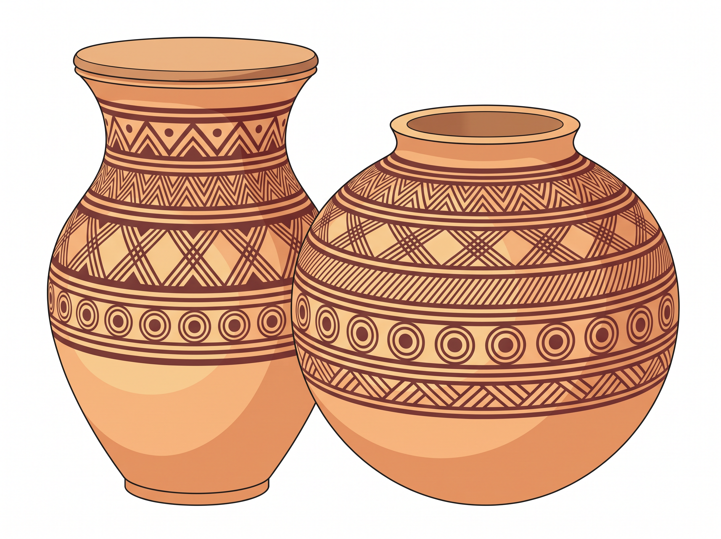
Fig. 1.15 – Harappan painted pottery.
1.5.1 Identifying Centres Of Production
How does an archaeologist decide that a place was a workshop rather than a shop, a house or a store?
In order to identify centres of craft production, archaeologists usually look for the following: raw material such as stone nodules, whole shells and copper ore; tools; unfinished objects; and rejects and waste material.
In fact, waste is one of the best indicators of craft work. For instance, if shell or stone is cut to make objects, then pieces of these materials will be discarded as waste at the place of production. A finished bead can travel anywhere. The chips struck off it cannot — they stay where the chisel fell.
Sometimes, larger waste pieces were used up to make smaller objects — a craftsperson wastes nothing valuable if a smaller bead can be cut from the offcut. But minuscule bits were usually left in the work area, too small to be worth saving and too small to sweep out.
Those minuscule bits carry a conclusion. These traces suggest that apart from small, specialised centres, craft production was also undertaken in large cities such as Mohenjodaro and Harappa. The cities did not only consume. They made things too.
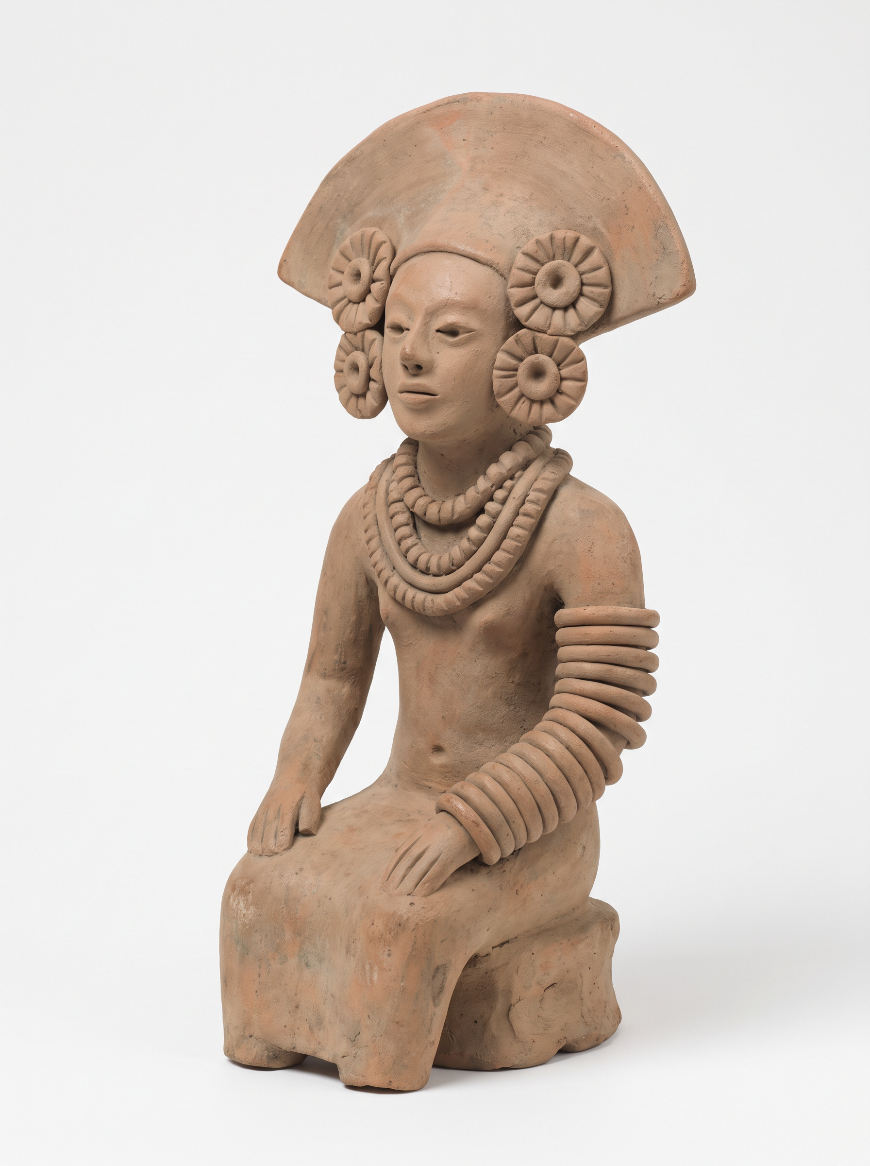
Fig. 1.16 – A seated terracotta figurine.
1.6 Strategies For Procuring Materials
The Problem Of A Rich Plain With Nothing In It
As is obvious, a variety of materials was used for craft production. While some, such as clay, were locally available, many — such as stone, timber and metal — had to be procured from outside the alluvial plain.
That word is the key to this whole section. An alluvial plain is flat land built up over ages from silt carried down by rivers. It is superb for growing crops and it gives endless clay. What it does not give is stone, metal ore or good timber. The Harappan heartland sat on some of the most fertile soil in the world, and on almost none of the raw material its craftspeople needed.
So the beads, the drills, the copper vessels, the weights and the seals you have just read about all rest on a single fact: somebody had to fetch the material from somewhere else.
How was it moved? Terracotta toy models of bullock carts suggest that this was one important means of transporting goods and people across land routes. Riverine routes along the Indus and its tributaries, as well as coastal routes, were also probably used. A river is a road that carries the weight for you, and the Indus system runs straight through the Harappan world.
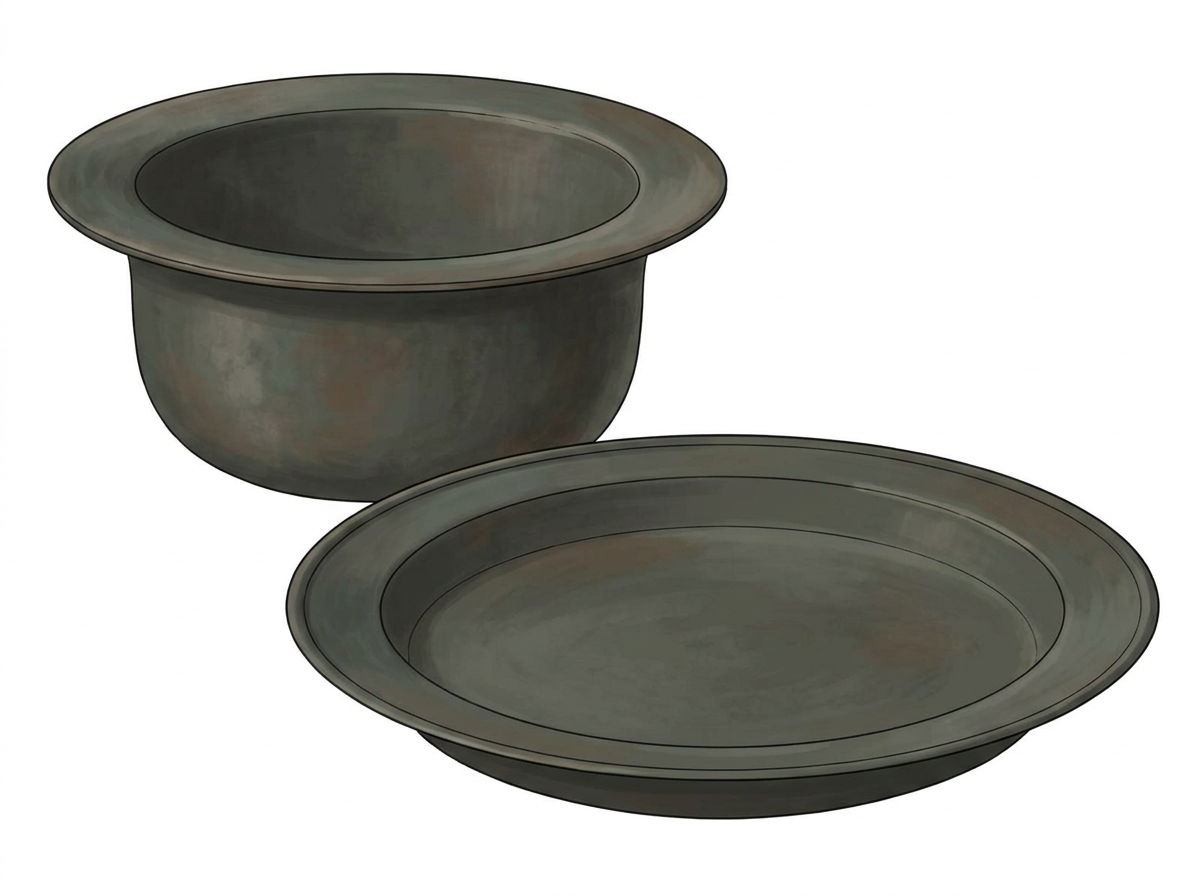
Fig. 1.17 – Copper and bronze vessels.
1.6.1 Materials From The Subcontinent And Beyond
The Harappans procured materials for craft production in various ways. The first was the simplest and the most striking: if you need a material, go and live where it is.
For instance, they established settlements such as Nageshwar and Balakot in areas where shell was available. Other such sites were Shortughai, in far-off Afghanistan, near the best source of lapis lazuli — a blue stone that was apparently very highly valued — and Lothal, which was near sources of carnelian (from Bharuch in Gujarat), steatite (from south Rajasthan and north Gujarat) and metal (from Rajasthan).
Look at what that list is actually telling you. Settlements were planted deliberately, hundreds of kilometres apart, each sitting on top of a material somebody in the cities wanted. Shortughai is in Afghanistan, far outside the plains — an entire Harappan settlement, at that distance, next to the best lapis lazuli in the region.
Sending Expeditions
Another strategy for procuring raw materials may have been to send expeditions to areas such as the Khetri region of Rajasthan (for copper) and south India (for gold). An expedition is not a settlement. It is a journey out and a journey back — and it must deal with whoever is already living there.
These expeditions established communication with local communities. How do we know? Occasional finds of Harappan artefacts, such as steatite micro beads, in these areas are indications of such contact. A Harappan bead lying in a non-Harappan region is a fingerprint. Somebody carried it there.
There is evidence in the Khetri area for what archaeologists call the Ganeshwar-Jodhpura culture, with its distinctive non-Harappan pottery and an unusual wealth of copper objects. It is possible that the inhabitants of this region supplied copper to the Harappans.
Pause on that possibility. It means the Harappans were not alone in their world, and not always the ones doing the making. Here is a separate people, with their own pottery, sitting on copper, and quite possibly supplying it. The Harappan cities depended on communities that were not Harappan at all.
1.6.2 Contact With Distant Lands
Now the reach becomes very long indeed. Look at Map 3, which sets the Harappan region beside West Asia.
Map
Map 3 Caption: The Harappan Civilisation and West Asia. Brief: Sketch map, not to scale, of West Asia and the north-western subcontinent, showing the Mediterranean Sea, Red Sea, Caspian Sea, Persian Gulf and Arabian Sea. Shade and label the regions MESOPOTAMIA, TURAN, DILMUN, MAGAN and MELUHHA, and mark Uruk, Ur, Altyn Depe, Shahr-i-Sokhta, Tepe Yahya, Rasal’ Janayz, Sutkagendor, Harappa and Lothal. Show the full extent of India as officially defined. Note on the map that the regional names are those used in ancient Mesopotamian texts, not modern countries.
Recent archaeological finds suggest that copper was also probably brought from Oman, on the south-eastern tip of the Arabian peninsula.
That is a bold claim to make about the third millennium BCE — the years from 3000 to 2001 BCE, the centuries in which the Harappan cities rose. So how is it made? Chemical analyses have shown that both the Omani copper and Harappan artefacts have traces of nickel, suggesting a common origin. Copper ore from a particular region carries its own impurities, like a chemical signature. Find the same signature in two places, and you have linked them.
The Jar That Went The Other Way
There are other traces of contact as well, and one of them travelled in the opposite direction.
A distinctive type of vessel — a large Harappan jar coated with a thick layer of black clay — has been found at Omani sites. Such thick coatings prevent the percolation of liquids; that is, they stop liquid from seeping out through the walls of the pot. So this was a jar built to carry something wet, over a distance.
We do not know what was carried in these vessels. But it is possible that the Harappans exchanged the contents of these vessels for Omani copper.
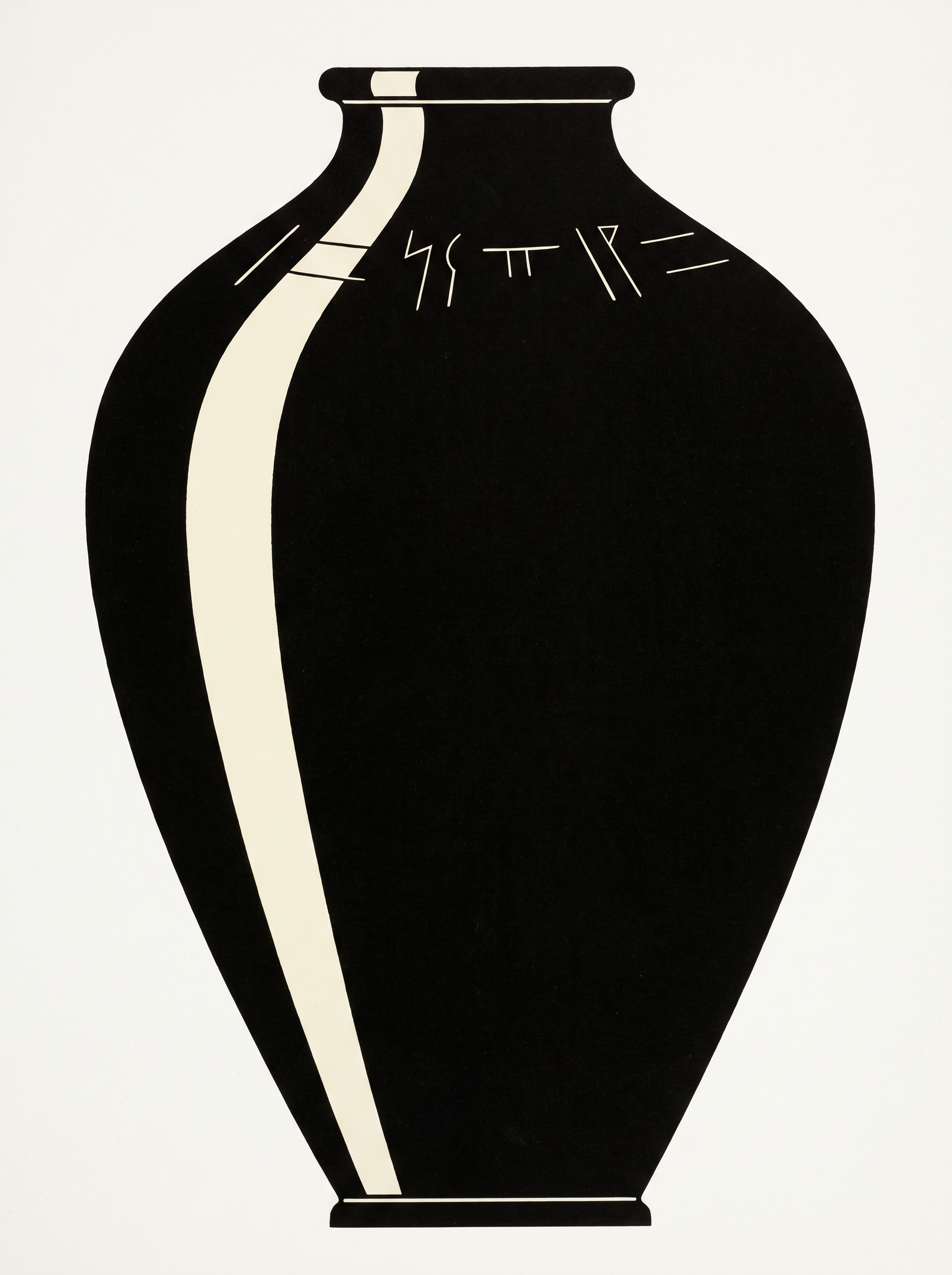
Fig. 1.18 – Profile of a Harappan jar.
What The Mesopotamians Wrote Down
Here the Harappans get an unusual gift. Their neighbours could write, and their neighbours’ writing can be read.
Mesopotamian texts datable to the third millennium BCE refer to copper coming from a region called Magan, perhaps a name for Oman. Mesopotamia, remember, is the land between the Tigris and the Euphrates, in what is now Iraq. And interestingly enough, copper found at Mesopotamian sites also contains traces of nickel — the same signature again, in a third place.
Other archaeological finds suggestive of long-distance contacts include Harappan seals, weights, dice and beads, turning up far from home.
In this context, it is worth noting that Mesopotamian texts mention contact with regions named Dilmun (probably the island of Bahrain), Magan and Meluhha — Meluhha possibly being the Harappan region. They mention the products from Meluhha: carnelian, lapis lazuli, copper, gold, and varieties of wood.
Read that list of exports again and match it against the last two sections. Carnelian, worked at Chanhudaro and Lothal. Lapis lazuli, from the country around Shortughai. Copper and gold, fetched by expedition. The Mesopotamian scribe is listing, without knowing it, the output of the Harappan procurement system.
One Mesopotamian myth even wishes upon Meluhha that its bird should be the haja-bird, whose call would be heard in the royal palace. Some archaeologists think the haja-bird was the peacock. Did it get this name from its call? Nobody can say. But notice what has happened here: we are hearing about the Harappans in someone else’s words, in someone else’s script, in someone else’s poetry. It is the closest thing to a Harappan text that we have — and it is not Harappan at all.
By Sea
It is likely that communication with Oman, Bahrain or Mesopotamia was by sea. Look at the map again: the coastline connects all of them, and the land in between is hard country.
The evidence points the same way. Mesopotamian texts refer to Meluhha as a land of seafarers. Besides, we find depictions of ships and boats on seals — the Harappans drew their own boats, and one of those drawings is in front of you in Fig. 1.21.
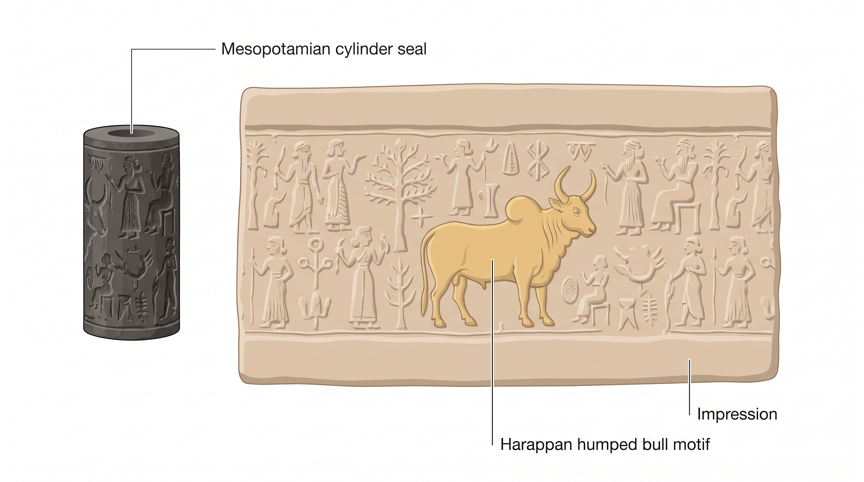
Fig. 1.19 – A Mesopotamian cylinder seal with a Harappan motif.
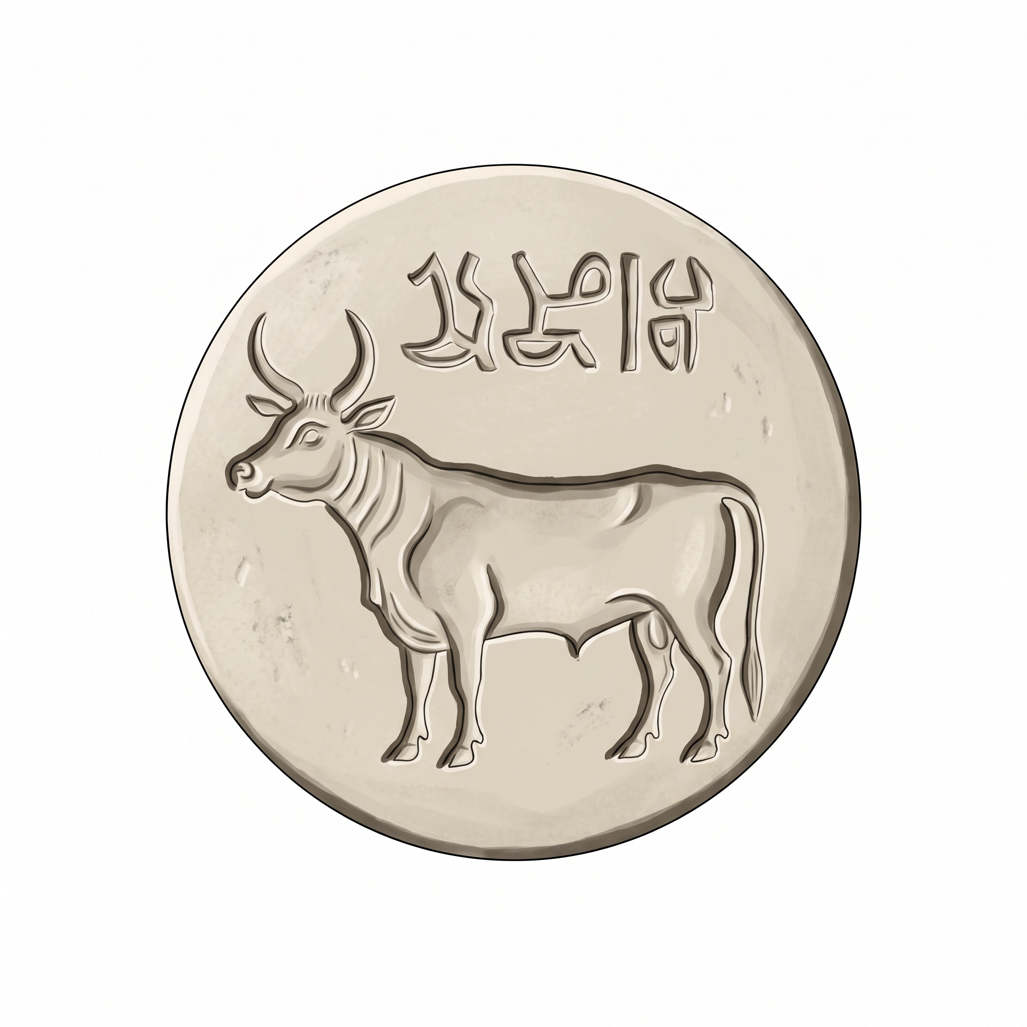
Fig. 1.20 – A Dilmun seal with Harappan motifs.
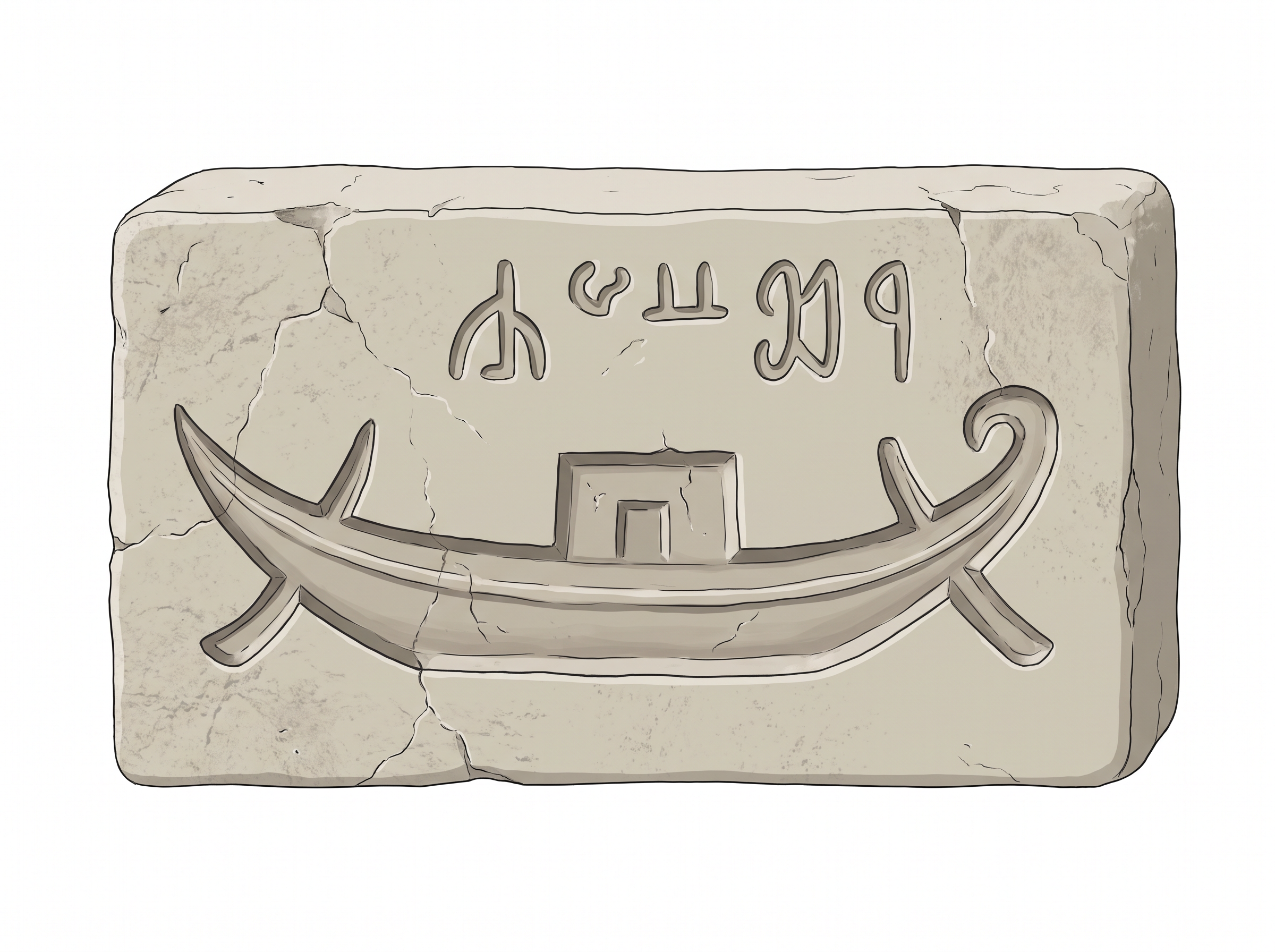
Fig. 1.21 – A Harappan seal depicting a boat.
1.7 Seals, Script, Weights
1.7.1 Seals And Sealings
Seals and sealings were used to facilitate long-distance communication. To see how, you have to picture the problem they solved.
Imagine a bag of goods being sent from one place to another — say, a sack of carnelian beads travelling from Chanhudaro to Mohenjodaro. It leaves your hands. It passes through the hands of a carter, a boatman, a porter. It arrives days later. How is the person at the other end to know that nobody opened it on the way?
Here is the Harappan answer. The mouth of the bag was tied with rope, and on the knot was affixed some wet clay, on which one or more seals were pressed, leaving an impression. That impression in the clay is called a sealing.
Now the clay dries hard. To open the bag, you must break the knot — and to break the knot you must break the sealing. There is no way to undo it and put it back, because you do not have the seal that made it. So if the bag reached with its sealing intact, it meant that it had not been tampered with.
The sealing did a second job as well. It conveyed the identity of the sender. The seal was a particular seal, belonging to a particular person, carrying a particular motif and a particular line of signs. Its impression was, in effect, a signature that could not be forged by anyone who did not hold the stone.
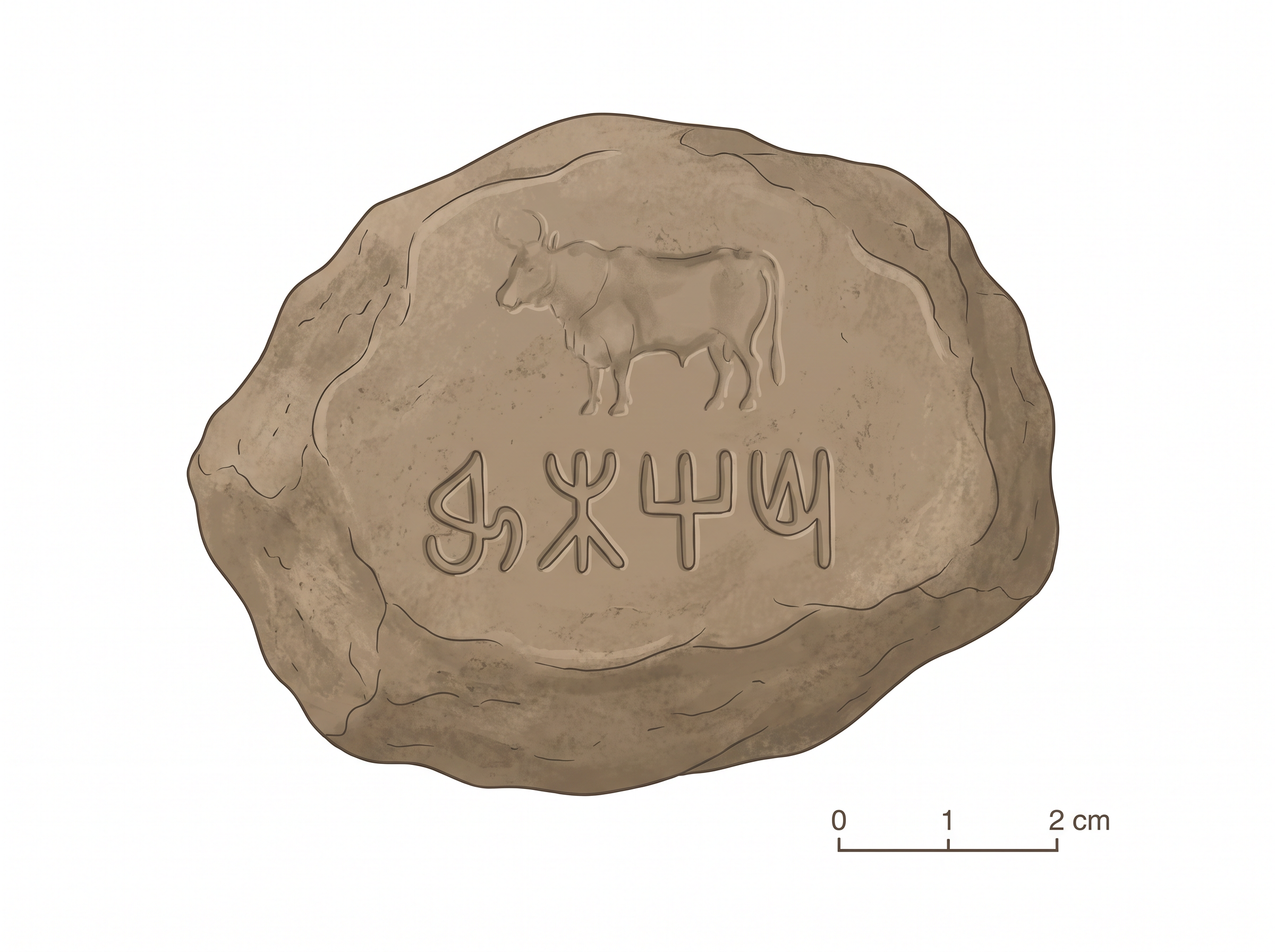
Fig. 1.22 – A sealing from Ropar.
1.7.2 An Enigmatic Script
Harappan seals usually have a line of writing, probably containing the name and title of the owner. Scholars have also suggested that the motif — generally an animal — conveyed a meaning to those who could not read. A picture works on everybody; a word works only on the literate. A seal carrying both is a seal designed for a mixed audience.
What The Script Is Not
Most inscriptions are short, the longest containing about 26 signs. Although the script remains undeciphered to date, one thing can be said about it with confidence: it was evidently not alphabetical.
Follow the reasoning, because it is a small piece of detective work. In an alphabetical script, each sign stands for a vowel or a consonant, and a language needs only a few dozen of those. The Harappan script has somewhere between 375 and 400 signs. That is far too many for an alphabet. Whatever those signs stand for, they are not single sounds.
It is also apparent that the script was written from right to left. How can anyone tell the direction of a script they cannot read? By looking at the crowding. Some seals show a wider spacing on the right and cramping on the left, as if the engraver began working from the right and then ran out of space. The mistake gives the game away. Anyone who has run out of room at the end of a line will recognise it.
Writing Everywhere — Or Not?
Consider the variety of objects on which writing has been found: seals, copper tools, rims of jars, copper and terracotta tablets, jewellery, bone rods, and even an ancient signboard. Fig. 1.23 shows the symbols and letters on what is considered a signboard found at Dholavira — signs large enough to be read from a distance, by whoever was passing.
And remember what does not survive. There may have been writing on perishable materials too — on cloth, on wood, on anything that rots. What we have is the writing that happened to be cut into stone, clay and metal.
Could this mean that literacy was widespread?
It is a real question, and the chapter leaves it open. Writing on tools and jars and jewellery suggests that script was part of ordinary life, not locked inside a palace. But a signboard proves only that somebody expected somebody to read it, and a name on a pot may have been read by very few.

Fig. 1.23 – Signboard symbols from Dholavira.
1.7.3 Weights
Exchanges were regulated by a precise system of weights. The weights were usually made of a stone called chert, and were generally cubical (you saw them in Fig. 1.24), with no markings on them at all.
The absence of markings is worth a moment. A weight with no number on it can only work if everybody already knows what it weighs — which means the sizes themselves were standard, and recognisable by sight and heft, across the whole Harappan world.
The system had two halves. The lower denominations of weights were binary: 1, 2, 4, 8, 16, 32. Each step is simply the previous one doubled:
\[1 \rightarrow 2 \rightarrow 4 \rightarrow 8 \rightarrow 16 \rightarrow 32\]
Doubling is the easiest possible check for a person with a balance and no numbers written down. You can verify a weight by seeing whether two of the smaller ones balance one of the larger.
The higher denominations followed the decimal system: 160, 200, 320, 640. These are the weights for heavier goods, and they step in tens rather than by doubling.
The smaller weights were probably used for weighing jewellery and beads — which makes sense, since those are the goods where a small error in weight is a large error in value. Metal scale-pans have also been found: the pans that hung from a balance, into which the goods and the weights were placed.
1.8 Ancient Authority
The Evidence For Somebody In Charge
There are indications of complex decisions being taken and implemented in Harappan society. Look back over what you have read so far, and the indications pile up.
Take, for instance, the extraordinary uniformity of Harappan artefacts. It is evident in pottery — go back to Fig. 1.25 and notice how alike the shapes and painted bands are — and in the seals, the weights and the bricks.
The bricks are the sharpest case of all. Bricks were obviously not produced in any single centre. Clay is heavy, and it is everywhere; you make your bricks where you are building. And yet they were of a uniform ratio throughout the region, from Jammu to Gujarat. Different brickmakers, hundreds of kilometres apart, working with different clay, turned out bricks in the same 4:2:1 proportion.
We have also seen that settlements were strategically set up in specific locations for various reasons — Nageshwar and Balakot beside the shell, Shortughai beside the lapis lazuli, Lothal within reach of carnelian, steatite and metal. Those are not accidents of settlement. They are choices.
Besides, labour was mobilised for making bricks and for the construction of massive walls and platforms. Four million person-days went into the foundations of Mohenjodaro alone.
Put the four together — a standard maintained across a subcontinent, settlements planted where the materials are, thousands of labourers moved and fed, and the same objects turned out in city after city — and one question becomes unavoidable.
Who organised these activities?
1.8.1 Palaces And Kings
So we go looking for the ruler. And this is where Harappan archaeology becomes genuinely strange.
If we look for a centre of power, or for depictions of people in power, archaeological records provide no immediate answers. There is no throne room, no royal tomb, no wall carved with a conquering king trampling his enemies. In Egypt and in Mesopotamia such things are impossible to miss. Here there is nothing of the sort.
There are two candidates, and both turn out to be labels rather than findings.
The ‘Palace’ And The ‘Priest-King’
A large building found at Mohenjodaro was labelled as a palace by archaeologists. But no spectacular finds were associated with it. It is a large building. That is all the evidence says. The word ‘palace’ came from the excavators, not from the ground.
A stone statue was labelled, and continues to be known, as the ‘priest-king’. Why? Because archaeologists were familiar with Mesopotamian history and its ‘priest-kings’, and have found parallels in the Indus region. In other words, they had a picture of what an ancient ruler looked like — borrowed from a neighbouring civilisation whose texts they could read — and they fitted this statue into it.
But as you will see in section 1.11, the ritual practices of the Harappan civilisation are not well understood yet. Nor are there any means of knowing whether those who performed such rituals also held political power. Two guesses are stacked here — that the man was a priest, and that a priest ruled — and neither has evidence under it.
This is analogy again, the same tool Mackay used on the querns in section 1.2. It worked reasonably well for a grinding stone. It works far less well for a man in stone, because a statue’s meaning is not written on its surface the way wear is written on a quern.
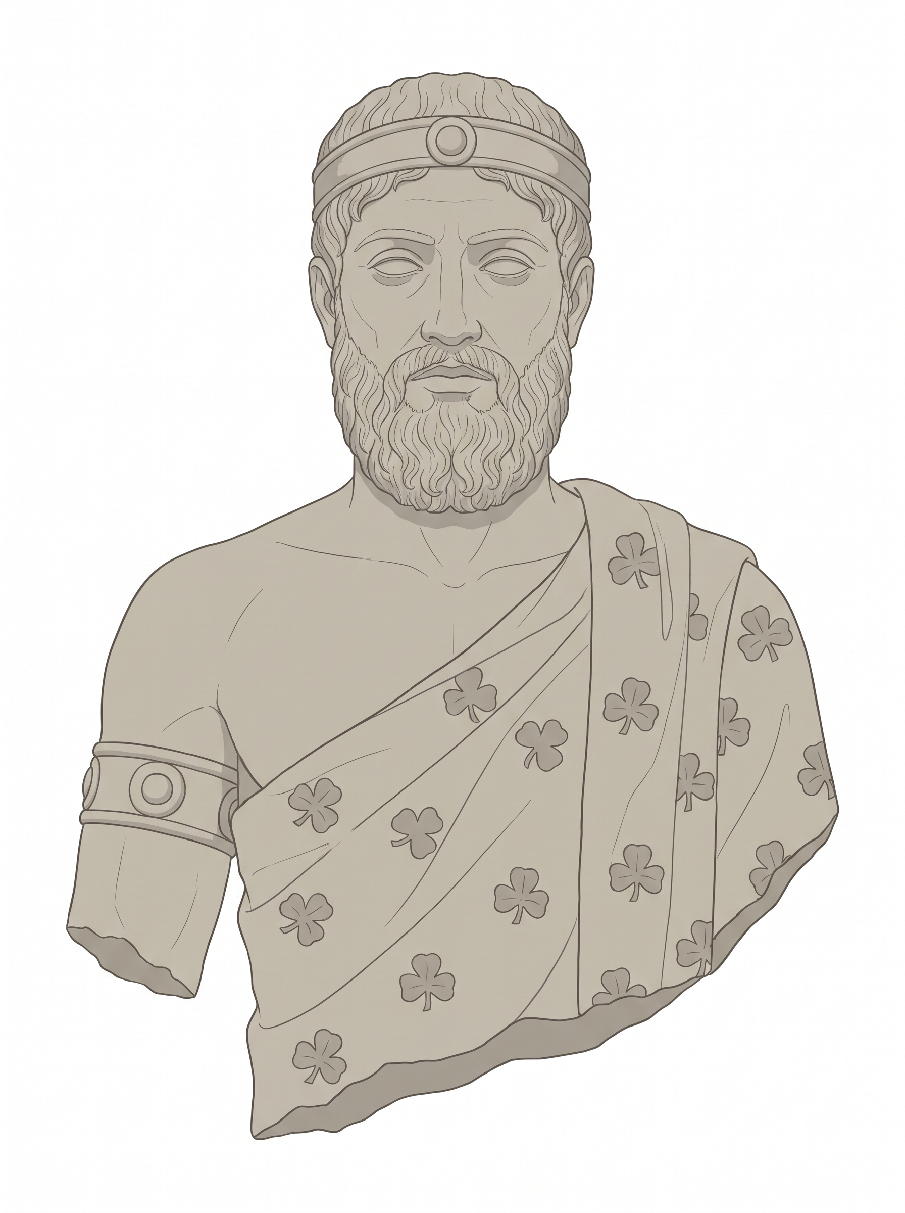
Fig. 1.26 – The ‘priest-king’ statue.
Three Answers, And No Agreement
With no ruler in the ground, archaeologists have had to argue from the pattern of the evidence rather than from any single find. They have arrived at very different conclusions.
Some archaeologists are of the opinion that Harappan society had no rulers, and that everybody enjoyed equal status. On this reading, the uniformity is not something imposed from above; it is something a community keeps up because it suits everybody.
Others feel there was no single ruler but several — that Mohenjodaro had a separate ruler, Harappa another, and so forth. A shared culture need not mean a shared government, any more than a shared script means one state today.
Yet others argue that there was a single state, given the similarity in artefacts, the evidence for planned settlements, the standardised ratio of brick size, and the establishment of settlements near sources of raw material. It is likely, on this view, that the Harappans practised some sort of democratic system, and that some of the structures, with their given features, were created apparently for utilitarian purposes rather than for the glory of any ruler.
Notice that all three groups are looking at exactly the same evidence. What separates them is not the finds but the question each brings: does uniformity across a huge region require a central power, or can free and equal communities produce it themselves? The evidence, as it stands, does not settle that question — and you should be suspicious of anyone who says it does.
1.9 The End Of The Civilisation
The Cities Empty Out
There is evidence that by c. 1800 BCE most of the Mature Harappan sites in regions such as Cholistan had been abandoned. Simultaneously, there was an expansion of population into new settlements in Gujarat, Haryana and western Uttar Pradesh.
Notice at once that these two things happen together. People are leaving one region and appearing in another. Whatever was happening, it was not a straightforward emptying of the land.
What Changed In The Places That Survived
In the few Harappan sites that continued to be occupied after 1900 BCE, there appears to have been a transformation of material culture. Not a destruction — a transformation. The people are still there. What they make and use is different.
It is marked by the disappearance of the distinctive artefacts of the civilisation: weights, seals, special beads. Writing, long-distance trade and craft specialisation also disappeared. In general, far fewer materials were used to make far fewer things.
Go back over the last five sections and see what that sentence has just swept away. The precise weight system of section 1.7, gone. The seals and the script, gone. The carnelian and lapis coming in from Gujarat and Afghanistan, gone. The workshop towns making beads for the cities, gone.
House construction techniques deteriorated and large public structures were no longer produced. No more platforms, no more warehouses, no more Great Baths. Overall, artefacts and settlements indicate a rural way of life, in what are called ‘Late Harappan’ or ‘successor cultures’.
The people remained. The cities did not.
Map
Map 4 Caption: Areas of Late Harappan occupation. Sketch map not to scale. Brief: Sketch map of the north-western subcontinent showing the Indus and the Arabian Sea, with dot scatters marking areas of Late Harappan occupation; label SWAT, CEMETERY H, LATE SISWAL, JHUKAR and RANGPUR II B-C. Show the full extent of India as officially defined. Note on the map that these are settlement areas of the Late Harappan period; boundaries shown are modern and given only for orientation.
Why? The Explanations, And Why None Of Them Is Enough
What brought about these changes? Several explanations have been put forward. These range from climatic change, deforestation, excessive floods, and the shifting and/or drying up of rivers, to overuse of the landscape.
Each of these is a real, physical process, and each would hurt a settlement badly. A river that shifts its course leaves a city stranded. A landscape stripped of its trees and worked too hard will not feed the people on it.
But here is the difficulty, and the chapter states it flatly. Some of these ‘causes’ may hold for certain settlements, but they do not explain the collapse of the entire civilisation. A river that dries up in Cholistan does not explain why the seals stopped being made in Gujarat. A flood in one valley does not explain why writing disappeared everywhere.
Whatever ended the Harappan world had to be something the whole of it shared.
The Missing Unifying Element
It appears that a strong unifying element — perhaps the Harappan state — came to an end.
What is the evidence for so large a claim? It is a list of absences, and each item on it is something you have already studied. The disappearance of the seals. The disappearance of the script. The disappearance of the distinctive beads and pottery. The shift from a standardised weight system to the use of local weights. And the decline and abandonment of the cities themselves.
Look hard at the third of those. Standard weights are not a fashion. They exist because far-apart strangers must trust the same measure. When a region gives up a shared standard and goes back to local weights, something that held those strangers together has stopped working.
The subcontinent would have to wait for over a millennium — more than a thousand years — for new cities to develop, in a completely different region.
An Old Answer: Invasion
For a long time there was a much more dramatic answer, and Source 3 lets you watch it being built and then taken apart.
It begins with bones. John Marshall, excavating Mohenjodaro, described human remains lying in an alley the excavators had nicknamed Deadman Lane. Sixteen skeletons of people with the ornaments that they were wearing when they died were found from the same part of Mohenjodaro in 1925.
Much later, in 1947, R.E.M. Wheeler, then Director-General of the ASI, tried to correlate this archaeological evidence with that of the Rigveda, the earliest known text in the subcontinent. Watch the reasoning carefully as you read him. He has bones from a city, and a text that speaks of a war-god who destroys forts, and he joins the two.
Then, in the 1960s, the evidence of a massacre at Mohenjodaro was questioned by an archaeologist named George Dales. He went back to the skeletons themselves and demonstrated that they did not belong to the same period.
Read Wheeler’s last sentence again. It is a courtroom sentence, not an archaeological one — a god is ‘accused’ on ‘circumstantial evidence’. Wheeler was an ex-army brigadier, writing in the year of Partition, and he was reading an ancient religious text as though it were a witness statement about a crime scene four thousand years old.
Dales did not argue with Wheeler’s poetry. He went back to the bones and asked what a massacre would actually leave in the ground: a destruction layer across the last phase of the city, burning, dead fighters with their weapons, some sign of a last defence at the fortified part of the site. None of it was there. And the skeletons, examined properly, were not even of one date — so they could not be the dead of a single terrible day.
That is how a discipline corrects itself. Not by finding a better story, but by asking what the story would have to have left behind, and then checking whether it did.
As you can see, a careful re-examination of the data can sometimes lead to a reversal of earlier interpretations.
A New Kind Of Evidence: DNA
In this respect, it is necessary to mention the recent archaeogenetic research carried out at the site of Rakhigarhi.
Rakhigarhi, located in Hisar district of Haryana, is the biggest Harappan city, spread over an area of 550 hectare. In order to study the genetic history of the Harappans, DNA was extracted from the skeletal remains excavated at Rakhigarhi. This research was carried out by the Deccan College Deemed University, Pune, in collaboration with the Centre for Cellular and Molecular Biology, Hyderabad, and The Harvard Medical College.
The analysis of the data indicates that the Harappans are the indigenous people of this region. The genetic roots of the Harappans go back to 10,000 BCE. The DNA of the Harappans has continued till today, and a majority of the South Asian population appears to be their descendants.
Because of the trade and cultural contacts of the Harappans with distant regions — the contacts you studied in section 1.6 — there is a mixture of genes in small quantity. The continuity, without any break in genetic history as well as cultural history, rules out large scale immigration of the so-called Aryans. This research also indicates that the people coming from bordering areas and distant regions were absorbed in the Indian society. At no stage was the genetic history of the Indians either discontinued or broken. As the Harappans started moving towards Iran and Central Asia, their genes also gradually spread in these regions.
The same team of researchers reconstructed 3D features of the Harappan people. The reconstructed facial features of the Harappans, male and female, show remarkable similarity with the modern population of Haryana. Thus, this study has indicated unbroken continuity for 5000 years in this region.
This account is drawn from Vasant Shinde and others, ‘An ancient Harrapan genome lacks ancestry from steppe pastoralists or Iranian farmers’, Cell, 179 (3), 2019.
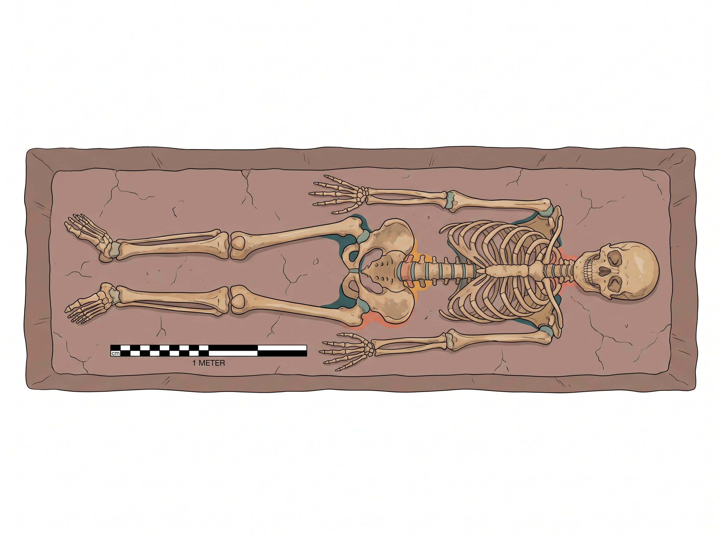
Fig. 1.27 – Harappan skeleton excavated at Rakhigarhi.
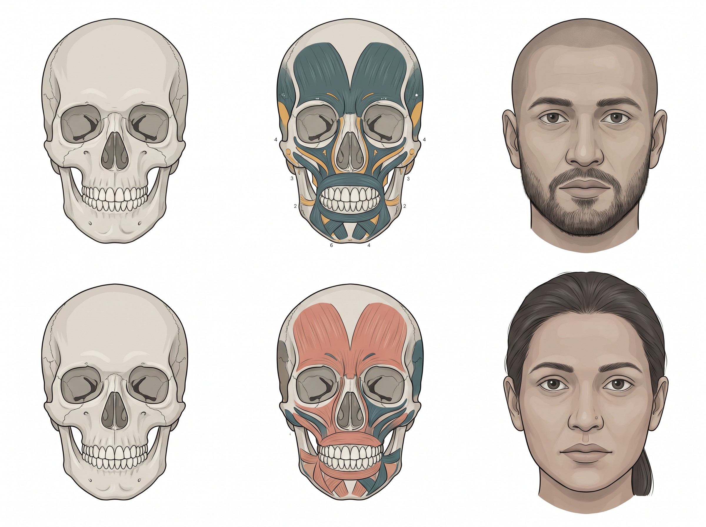
Fig. 1.28 – Reconstructed Harappan facial features.
Notice how much the ground has shifted in one section. Marshall dug up bones and described them. Wheeler read a text and accused a god. Dales re-examined the same bones and found no battle. And a laboratory, working on a skeleton from Rakhigarhi, has asked a question none of them could ask — not how these people died, but who their descendants are.
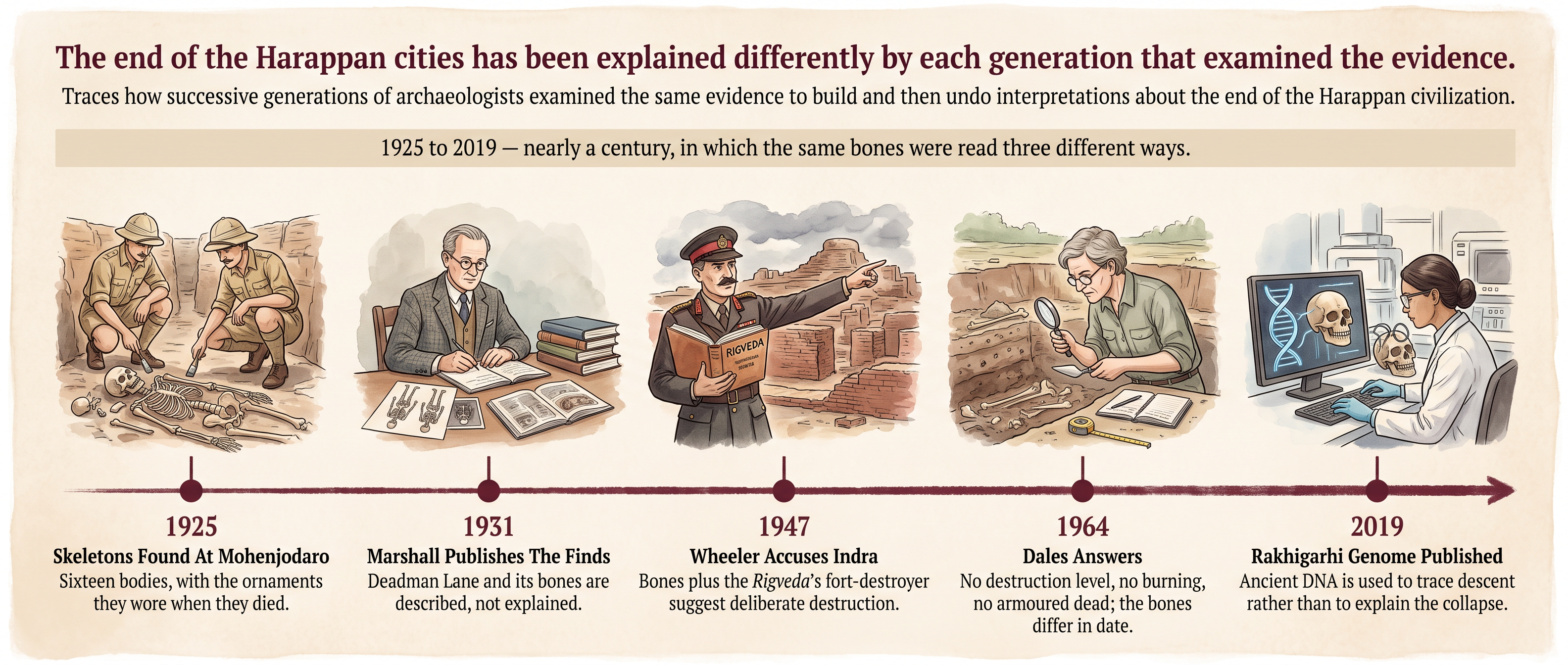
Fig. 1.29 – How One Interpretation Was Built And Undone.
1.10 Discovering The Harappan Civilisation
So far, we have examined facets of the Harappan civilisation in the context of how archaeologists have used evidence from material remains to piece together parts of a fascinating history. However, there is another story as well — about how archaeologists ‘discovered’ the civilisation.
Notice the quotation marks around that word. The Harappans were never lost to themselves. They were lost to us.
When Harappan cities fell into ruin, people gradually forgot all about them. When men and women began living in the area millennia later, they did not know what to make of the strange artefacts that occasionally surfaced — washed out by floods, exposed by soil erosion, turned up while ploughing a field, or found while digging for treasure.
Picture that for a moment. For thousands of years, farmers in the Punjab and Sind were turning up seals, beads and bricks with their ploughs, and had no way of knowing that they were holding the oldest cities in the subcontinent in their hands. The evidence was never hidden. What was missing was a frame of reference to put it in.
1.10.1 Cunningham’s Confusion
When Cunningham, the first Director-General of the ASI, began archaeological excavations in the mid-nineteenth century, archaeologists preferred to use the written word — texts and inscriptions — as a guide to investigations. You read a text, you find the place it describes, and you dig there.
That single habit shaped everything that followed. It decides which sites get dug, and therefore which pasts get found.
Cunningham’s main interest was in the archaeology of the Early Historic period (c. sixth century BCE-fourth century CE) and later periods. To find sites worth excavating, he used the accounts left by Chinese Buddhist pilgrims who had visited the subcontinent between the fourth and seventh centuries CE. He also collected, documented and translated inscriptions found during his surveys. When he excavated sites, he tended to recover artefacts that he thought had cultural value.
Now apply that framework to Harappa, and watch it fail.
A site like Harappa was not part of the itinerary of the Chinese pilgrims, and was not known as an Early Historic city. It therefore did not fit very neatly within his framework of investigation. It was not described in any text he had; it belonged to no period he was looking for; and it produced objects he could not place.
So, although Harappan artefacts were found fairly often during the nineteenth century, and some of these reached Cunningham, he did not realise how old these were.
A Harappan seal was given to Cunningham by an Englishman. He noted the object, but unsuccessfully tried to place it within the time-frame with which he was familiar. This was because he, like many others, thought that Indian history began with the first cities in the Ganga valley — the cities you will meet in the next chapter.
Given his specific focus, it is not surprising that he missed the significance of Harappa. He was not careless. He was looking with the wrong question.
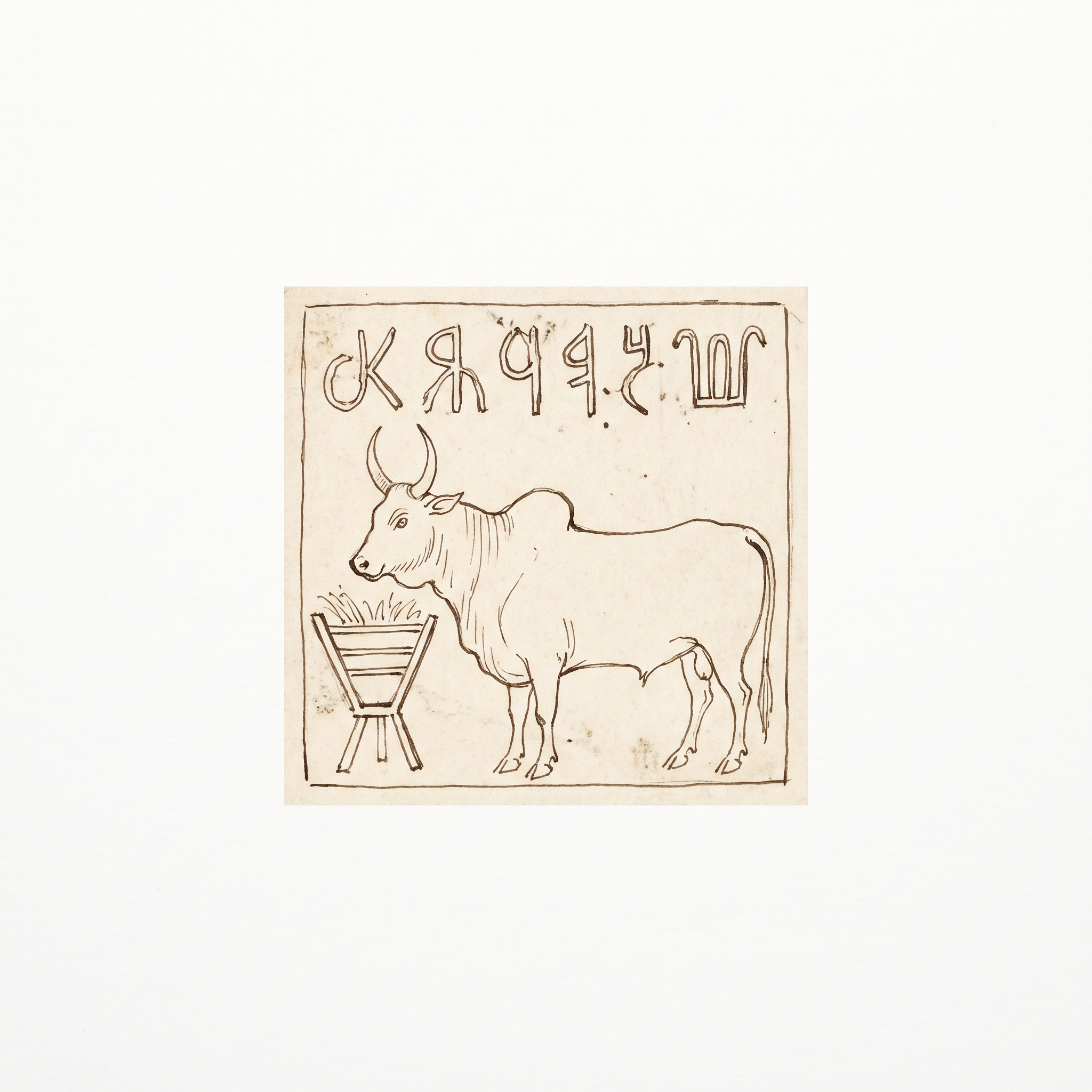
Fig. 1.30 – Cunningham’s sketch of a Harappan seal.
1.10.2 A New Old Civilisation
Subsequently, seals were discovered at Harappa by archaeologists such as Daya Ram Sahni in the early decades of the twentieth century — and this time they were found in layers that were definitely much older than Early Historic levels. It was then that their significance began to be realised.
That phrase, ‘in layers’, is doing all the work. To see why, you need to know how a site is built and how it is read.
Sites, Mounds And Layers
Archaeological sites are formed through the production, use and discarding of materials and structures. When people continue to live in the same place, their constant use and reuse of the landscape results in the build-up of occupational debris — the rubbish, broken pots, collapsed walls and trodden floors of daily life. This build-up is called a mound.
Brief or permanent abandonment results in the alteration of the landscape by wind or water activity and erosion. Occupations are detected by traces of ancient materials found in layers, which differ from one another in colour, texture and the artefacts that are found in them. Abandonments or desertions produce what are called ‘sterile layers’, which can be identified by the absence of such traces — a band of soil with nothing human in it, meaning nobody was living there.
Generally, the lowest layers are the oldest and the highest are the most recent. This is common sense turned into a method: you cannot drop something into a layer that has not been laid down yet.
The study of these layers is called stratigraphy. Artefacts found in layers can be assigned to specific cultural periods, and can thus provide the cultural sequence for a site — the order in which its ways of life followed one another.
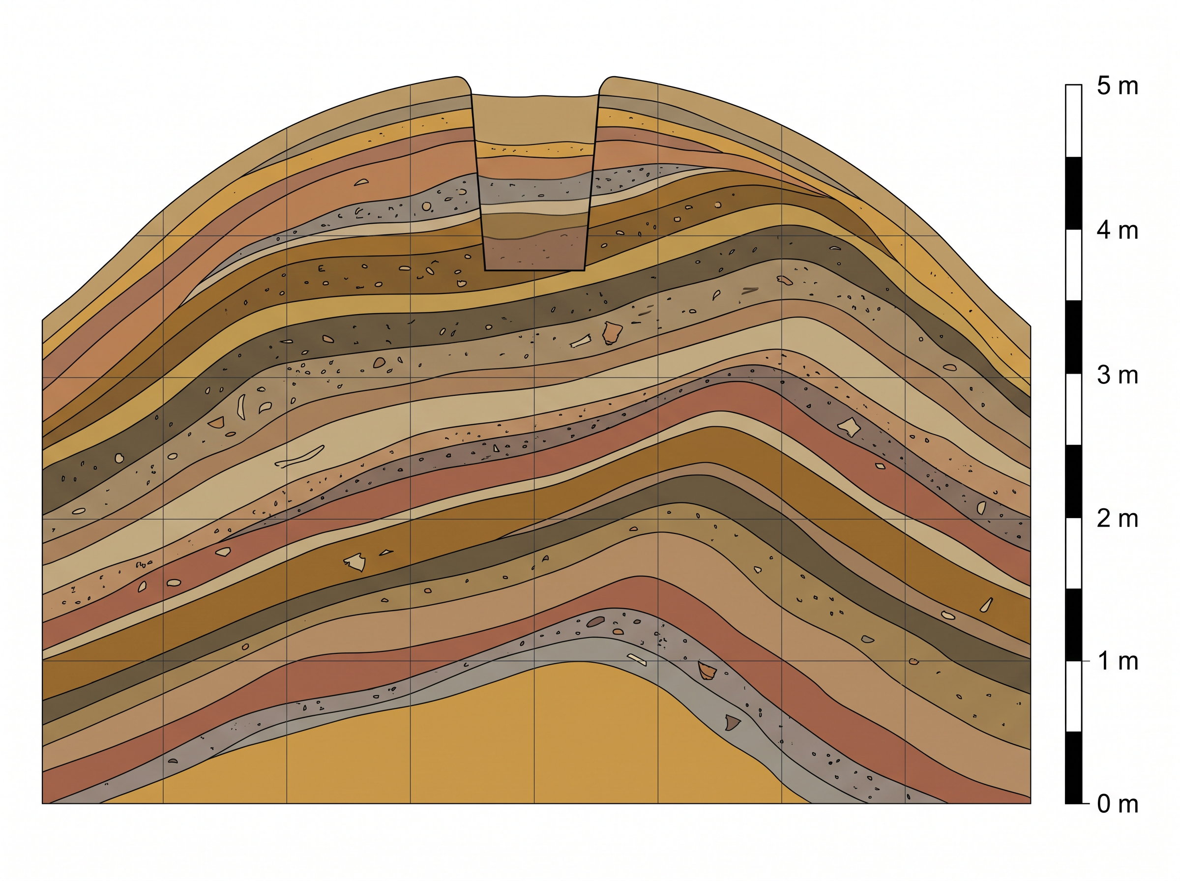
Fig. 1.31 – Stratigraphy of a small mound.
Look carefully at Fig. 1.31 and notice the warning printed under it. The layers are not exactly horizontal. They sag, tilt and cut into each other, because rubbish does not settle in neat sheets. An archaeologist who assumes flat, even layers will misread the mound.
Marshall’s Announcement
Sahni’s seals lay in old layers. Another archaeologist, Rakhal Das Banerji, found similar seals at Mohenjodaro, leading to the conjecture that these sites were part of a single archaeological culture — two places, hundreds of kilometres apart, producing the same distinctive objects.
Based on these finds, in 1924, John Marshall, Director-General of the ASI, announced the discovery of a new civilisation in the Indus valley to the world. As S.N. Roy noted in The Story of Indian Archaeology, ‘Marshall left India three thousand years older than he had found her.’
The announcement carried further than India, and for a reason that belongs to section 1.6. Similar, till-then-unidentified seals had been found at excavations at Mesopotamian sites. So it was then that the world knew not only of a new civilisation, but also of one contemporaneous with Mesopotamia. The seal that Cunningham could not place had been placed at last — by comparing it with a find a thousand miles away.
What Marshall Changed, And What He Lost
In fact, John Marshall’s stint as Director-General of the ASI marked a major change in Indian archaeology. He was the first professional archaeologist to work in India, and he brought his experience of working in Greece and Crete to the field.
More importantly, though like Cunningham he too was interested in spectacular finds, he was equally keen to look for patterns of everyday life. That shift is the reason this chapter can tell you about drains, querns and bathrooms rather than only about treasure.
And yet his method cost the discipline dearly. Marshall tended to excavate along regular horizontal units, measured uniformly throughout the mound, and in doing so he ignored the stratigraphy of the site. He dug in flat slices of fixed depth. But as Fig. 1.31 shows, the layers themselves are not flat.
This meant that all all the artefacts recovered from the same unit were grouped together, even if they were actually found at different stratigraphic layers. A pot from an early layer and a pot from a later one could end up in the same box, labelled the same way. As a result, valuable information about the context of these finds was irretrievably lost.
1.10.3 New Techniques And Questions
It was R.E.M. Wheeler, after he took over as Director-General of the ASI in 1944, who rectified this problem. Wheeler recognised that it was necessary to follow the stratigraphy of the mound rather than dig mechanically along uniform horizontal lines. You dig the layers the site actually has, not the slices you have decided on in advance.
Moreover, as an ex-army brigadier, he brought with him a military precision to the practice of archaeology — measured trenches, strict recording, and a working day that began before dawn.
Partition, And A New Map Of The Search
The frontiers of the Harappan civilisation have little or no connection with present-day national boundaries. The Harappans did not know where the borders of the twentieth century would fall.
However, with the partition of the subcontinent and the creation of Pakistan, the major known sites became part of Pakistan. Harappa and Mohenjodaro — the two sites on which almost everything in this chapter has rested — were now across an international border.
This has spurred Indian archaeologists to try and locate sites in India. An extensive survey in Kutch has revealed a number of Harappan settlements, and explorations in Punjab and Haryana have added to the list of Harappan sites. While Kalibangan, Lothal, Rakhi Garhi and most recently Dholavira have been discovered, explored and excavated as part of these efforts, fresh explorations continue.
It is worth noticing what has happened here. Where archaeologists dig is decided partly by the evidence and partly by the politics of the present. Cunningham dug where the Chinese pilgrims had walked. Indian archaeologists after 1947 dug where the new border left them. Neither choice is dishonest; both shape what we end up knowing.
The Questions Being Asked Now
Over the decades, new issues have assumed importance. Where some archaeologists are keen to obtain a cultural sequence, others try to understand the logic underlying the location of specific sites — why a settlement is here and not five kilometres away. They also grapple with the wealth of artefacts, trying to figure out the functions these may have served.
Since the 1980s, there has also been growing international interest in Harappan archaeology. Specialists from the subcontinent and abroad have been jointly working at both Harappa and Mohenjodaro. They are using modern scientific techniques, including surface exploration to recover traces of clay, stone, metal, and plant and animal remains, as well as to minutely analyse every scrap of available evidence.
That last phrase is the measure of how far the discipline has travelled. Cunningham recovered the objects he thought had cultural value. Today’s archaeologists sift the soil for a burnt seed and a fragment of bone. These explorations promise to yield interesting results in the future.
1.11 Problems Of Piecing Together The Past
What The Ground Keeps, And What It Eats
As we have seen, it is not the Harappan script that helps in understanding this ancient civilisation. Rather, it is material evidence that allows archaeologists to better reconstruct Harappan life. This material could be pottery, tools, ornaments, household objects, and so on.
But that material is not a fair sample of what the Harappans owned. It is a sample chosen for us — by decay, and by the habits of the people themselves.
Start with decay. Organic materials such as cloth, leather, wood and reeds generally decompose, especially in tropical regions. What survive are stone, burnt clay (or terracotta), metal, and other hard materials.
Now think about what that erases. Clothes. Shoes. Baskets. Rope. Furniture. Mats. Toys. Doors. Boats. The upper storeys of houses. Whole trades — carpentry, weaving, leatherwork — are represented in our evidence by almost nothing, not because the Harappans did not practise them but because their products rotted.
The Second Filter: People Throw Away Rubbish, Not Treasure
There is a second filter, and it is even less obvious.
It is important to remember that only broken or useless objects would have been thrown away. Other things would probably have been recycled — a cracked copper vessel becomes a lump of copper, a broken bead becomes a smaller bead.
Consequently, valuable artefacts that are found intact were either lost in the past, or hoarded and never retrieved. In other words, such finds are accidental rather than typical.
Sit with that sentence, because it turns a museum case upside down. The beautiful, whole, precious objects in a display of Harappan artefacts are not there because they were ordinary. They are there because somebody dropped them and could not find them again, or hid them and never came back. The Harappan world we can see is built out of accidents.
1.11.1 Classifying Finds
Recovering artefacts is just the beginning of the archaeological enterprise. Archaeologists then classify their finds — and classification is not a clerk’s job. It is where interpretation quietly begins.
One simple principle of classification is in terms of material: stone, clay, metal, bone, ivory, and so on. This is the easy half. A trained eye and a laboratory can settle what a thing is made of.
The second principle, and the more complicated one, is in terms of function. Archaeologists have to decide whether, for instance, an artefact is a tool or an ornament, or both, or something meant for ritual use. And nothing in the object announces the answer.
Three Ways Of Guessing At Function
The first way is resemblance. An understanding of the function of an artefact is often shaped by its resemblance with present-day things. Beads, querns, stone blades and pots are obvious examples — you know what a pot is for because you have used one. This is the reasoning by analogy you met with Mackay’s querns in section 1.2, and its dangers have not gone away.
The second way is context. Archaeologists also try to identify the function of an artefact by investigating the context in which it was found. Was it found in a house, in a drain, in a grave, in a kiln? The same object means different things in different places. A pot in a kitchen is cookware; the same pot in a grave is a gift to the dead.
The third way is indirect evidence, used when the thing itself has not survived. For instance, though there are traces of cotton at some Harappan sites, to find out about clothing we have to depend on indirect evidence, including depictions in sculpture. We know they had cotton. We do not have the garment. So we look at what people are wearing in the sculptures instead.
Frames Of Reference
Above all, archaeologists have to develop frames of reference. You have already watched one being built.
We have seen that the first Harappan seal that was found could not be understood till archaeologists had a context in which to place it — both in terms of the cultural sequence in which it was found, and in terms of a comparison with finds in Mesopotamia. The seal did not change between Cunningham’s hands and Marshall’s. The frame around it did.
1.11.2 Problems Of Interpretation
The problems of archaeological interpretation are perhaps most evident in attempts to reconstruct religious practices. This is the hardest thing a person can try to dig up, because belief leaves no residue of its own.
The ‘Unfamiliar Therefore Religious’ Rule
Early archaeologists thought that certain objects which seemed unusual or unfamiliar may have had a religious significance. Read that carefully. It is not a finding. It is a rule of thumb — and a rather revealing one. If we cannot explain it, it must be religious.
These included terracotta figurines of women, heavily jewelled, some with elaborate head-dresses. These were regarded as mother goddesses. Rare stone statuary of men in an almost standardised posture, seated with one hand on the knee — such as the ‘priest-king’ of section 1.8 — was also similarly classified.
In other instances, structures have been assigned ritual significance. These include the Great Bath, and the fire altars found at Kalibangan and Lothal.
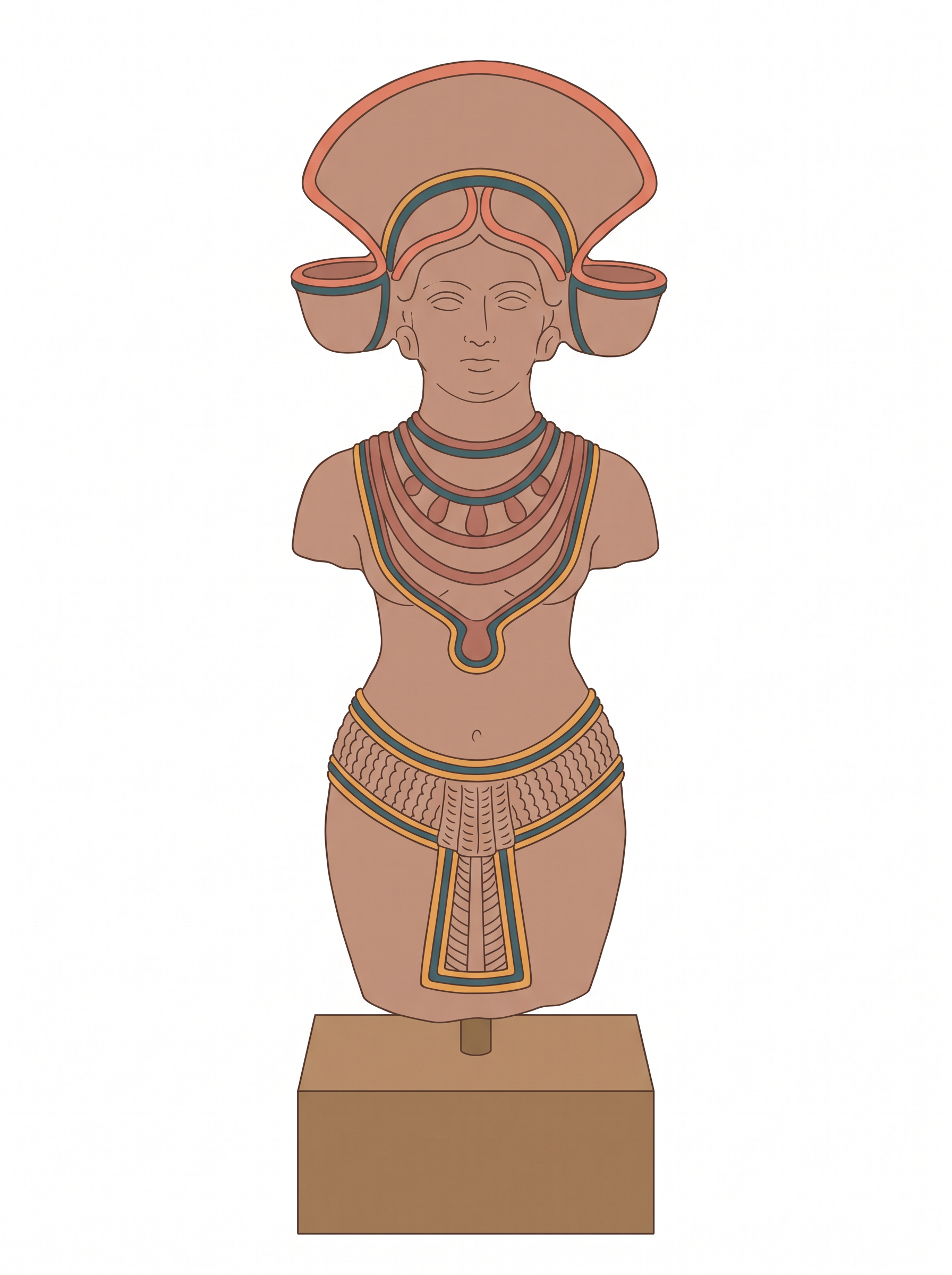
Fig. 1.32 – A terracotta female figurine.
Reading The Seals
Attempts have also been made to reconstruct religious beliefs and practices by examining seals, some of which seem to depict ritual scenes. Others, with plant motifs, are thought to indicate nature worship.
Some animals — such as the one-horned animal, often called the ‘unicorn’ — depicted on seals seem to be mythical, composite creatures, put together from parts of real animals.
In some seals, a figure shown seated cross-legged in a ‘yogic’ posture, sometimes surrounded by animals, has been regarded as a depiction of ‘proto-Shiva’ — that is, an early form of one of the major deities of Hinduism. Besides, conical stone objects have been classified as lingas.

Fig. 1.33 – A ‘proto-Shiva’ seal.
The Assumption Underneath
Many reconstructions of Harappan religion are made on the assumption that later traditions provide parallels with earlier ones. This is because archaeologists often move from the known to the unknown — that is, from the present to the past.
Sometimes that works. While this is plausible in the case of stone querns and pots, it becomes far more speculative when we extend it to ‘religious’ symbols. A quern grinds grain in any century. A symbol does not carry its meaning across four thousand years unchanged.
Let us look, for instance, at the ‘proto-Shiva’ seals, and test the claim against the earliest text we have.
The Rigveda, the earliest religious text, compiled c. 1500-1000 BCE, mentions a god named Rudra — a name used for Shiva in later Puranic traditions, in the first millennium CE. So far, so promising.
But now compare the details. Unlike Shiva, Rudra in the Rigveda is neither depicted as Pashupati — lord of animals in general and cattle in particular — nor as a yogi. And those two features are exactly what the seal is said to show: a figure surrounded by animals, seated in a ‘yogic’ posture.
In other words, this depiction does not match the description of Rudra in the Rigveda. The parallel that was supposed to link the seal to later Hinduism does not, on inspection, hold in the one early text we can read.
Is this, then, possibly a shaman, as some scholars have suggested?
Cones: Lingas Or Gamesmen?
The same difficulty returns in a smaller and sharper form. Look at Fig. 1.34, and at what one of the earliest excavators said about the little stone cones found at Mohenjodaro.
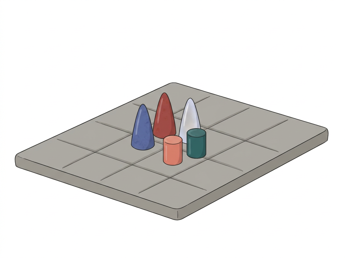
Fig. 1.34 – Small stone cones: gamesmen or lingas?
Notice that the stone slab in Fig. 1.34 is squared and grooved like a board. That is context doing its work again — and it pulls the interpretation one way. Take the cones off the board and put them in a shrine, and it would pull the other. Nothing about the cones has changed.
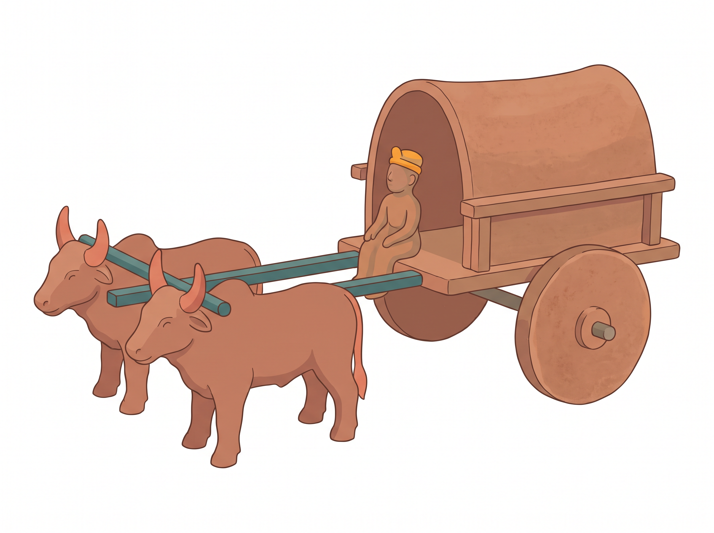
Fig. 1.35 – A terracotta model cart.
What Has Been Achieved, And What Has Not
What has been achieved after so many decades of archaeological work?
A great deal. We have a fairly good idea of the Harappan economy — the farming, the crafts, the raw materials, the trade. We have been able to tease out social differences. And we have some idea of how the civilisation functioned.
It is really not clear how much more we would know if the script were to be deciphered. If a bilingual inscription is found — the same text written in Harappan and in a script we can already read — questions about the languages spoken by the Harappans could perhaps be put to rest. That is what a bilingual gives you: a key, because you already know one half of the lock.
The Questions Still Open
Several reconstructions remain speculative at present, and it is worth naming them plainly.
Was the Great Bath a ritual structure? How widespread was literacy? Why do Harappan cemeteries show little social differentiation?
Also unanswered are questions on gender. Did women make pottery, or did they only paint pots, as at present? What about other craftspersons? What were the terracotta female figurines used for?
Very few scholars have investigated issues of gender in the context of the Harappan civilisation, and this is a whole new area for future work. Notice what that means. Half the population of a great civilisation has barely been asked about. That is not a gap in the evidence. It is a gap in the questions historians have chosen to put to the evidence — and a gap of that kind can be closed by a new generation of scholars.
More research is also required on the relationship between the Harappans and the Vedic people, as some scholars have argued that the authors of the Harappan civilisation and the Vedic people were the same.
1.12 Summary
The Civilisation And Its Phases
- The Harappan Civilisation, also known as the Indus Valley Civilisation, takes its name from Harappa, the place where it was identified.
- Its total span runs from 6000 BCE to 1300 BCE: Early Harappan (6000-2600 BCE), the formative phase; Mature Harappan (2600-1900 BCE), the urban and most prosperous phase; and Late Harappan (1900-1300 BCE), the phase of decline.
- Harappan pottery, baked and unbaked bricks, seals, weights, beads and copper and bronze objects have been found from Afghanistan and Baluchistan to Maharashtra.
- More than 2000 sites are known, most of them between the Indus and Saraswati basins, with nearly two-thirds in the Saraswati basin. Five major cities have been identified: Rakhigarhi, Mohenjodaro, Harappa, Dholavira and Ganweriwala.
- The cities grew out of earlier farming communities in the same region, dated around 7000 BCE. They were not brought in from outside.
Food, Farming And Water
- The Harappans ate a wide range of plants and animals, including fish. Wheat, barley, lentil, chickpea and sesame are found at their sites; millets in Gujarat; rice rarely.
- Charred grains and seeds are studied by archaeo-botanists, and animal bones by archaeo-zoologists, who show that cattle, sheep, goat, buffalo and pig were domesticated.
- Ploughing is inferred from bull images, from terracotta plough models at Cholistan and Banawali, and from the ploughed field at Kalibangan, whose furrows cross at right angles.
- Most sites lie in semi-arid land, so irrigation was probably needed. Canals are traced at Shortughai, wells were widely used, and Dholavira has great stone reservoirs.
The Planned City
- Mohenjodaro is divided into a smaller, higher Citadel, raised on mud brick platforms and walled, and a larger, lower Lower Town, also walled.
- The platforms alone would have required about four million person-days of labour.
- Streets ran on an approximate grid, and streets with drains were laid out before the houses, so every house needed a wall along a street.
- Houses were built around courtyards, with no ground-level windows, an entrance that hid the interior, a brick bathroom draining into the street, and often a well. Mohenjodaro had about 700 wells.
- Bricks everywhere, sun-dried or baked, followed one standard ratio of 4:2:1.
- On the Citadel stood the warehouse and the Great Bath, a watertight tank whose uniqueness and context have led scholars to suggest it was used for a special ritual bath.
Society, Crafts And Trade
- Social differences are sought in burials and in artefacts. Harappan graves are mostly plain pits, and precious things were generally not buried with the dead.
- Artefacts are classified as utilitarian or luxuries, but objects like faience spindle whorls cross the line. Rare and costly objects concentrate in the big cities, and all Harappan gold jewellery comes from hoards.
- Chanhudaro, under 7 hectares against Mohenjodaro’s 125, was almost entirely devoted to craft production. Nageshwar and Balakot worked shell near the coast.
- Craft centres are identified by raw material, tools, unfinished objects, rejects and waste — waste being the best indicator of all.
- Raw materials had to come from outside the alluvial plain: shell from the coast, lapis lazuli near Shortughai, carnelian, steatite and metal near Lothal, copper from Khetri, gold from south India.
- Contact reached Oman, Bahrain and Mesopotamia. Nickel traces link Omani, Harappan and Mesopotamian copper; a black-coated Harappan jar was found in Oman; and Mesopotamian texts name Dilmun, Magan and Meluhha, listing carnelian, lapis lazuli, copper, gold and wood as Meluhha’s products.
- Seals identified the sender and sealings proved a bag had not been opened. The script, undeciphered, has 375 to 400 signs, runs right to left, and never appears in long inscriptions — the longest has about 26 signs.
- Weights of chert, cubical and unmarked, ran binary in the lower denominations (1, 2, 4, 8, 16, 32) and decimal in the higher (160, 200, 320, 640).
How The Civilisation Was Found, And How It Is Read
- Cunningham, digging from the mid-nineteenth century, used texts and the Chinese pilgrims’ accounts as his guide. Harappa fitted no text he had, so he missed its significance.
- Seals found by Daya Ram Sahni at Harappa, in layers older than Early Historic levels, and by Rakhal Das Banerji at Mohenjodaro, led John Marshall to announce the discovery in 1924 — and matching seals from Mesopotamia showed the civilisation was contemporaneous with it.
- Marshall dug in uniform horizontal units and ignored stratigraphy, so the context of many finds was irretrievably lost. Wheeler, from 1944, dug by the layers of the mound instead.
- After Partition the major known sites lay in Pakistan, which spurred exploration in Kutch, Punjab and Haryana, and the excavation of Kalibangan, Lothal, Rakhi Garhi and Dholavira.
- Artefacts are classified by material and by function, and function is guessed at from resemblance to present-day things, from the context of the find, and from indirect evidence.
- Interpretation is hardest for religion. Mother goddesses, the ‘proto-Shiva’ seal and stone lingas all rest on reading later traditions back into an earlier culture — and Rudra in the Rigveda is neither Pashupati nor a yogi.
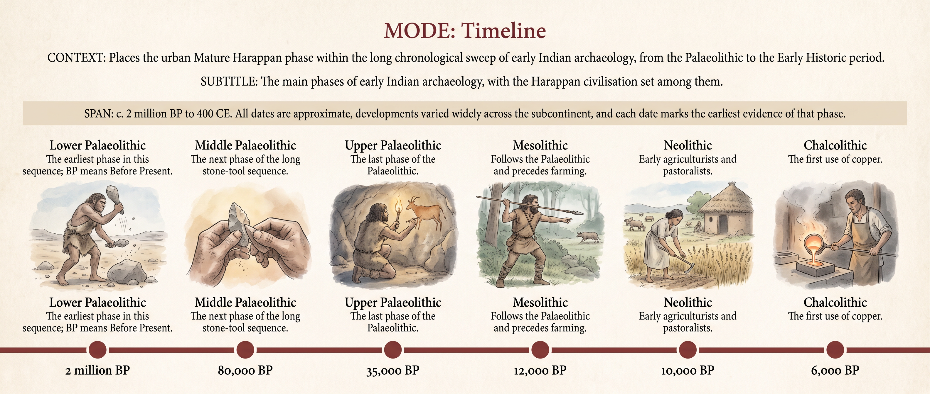
Fig. 1.36 – Major Periods In Early Indian Archaeology.
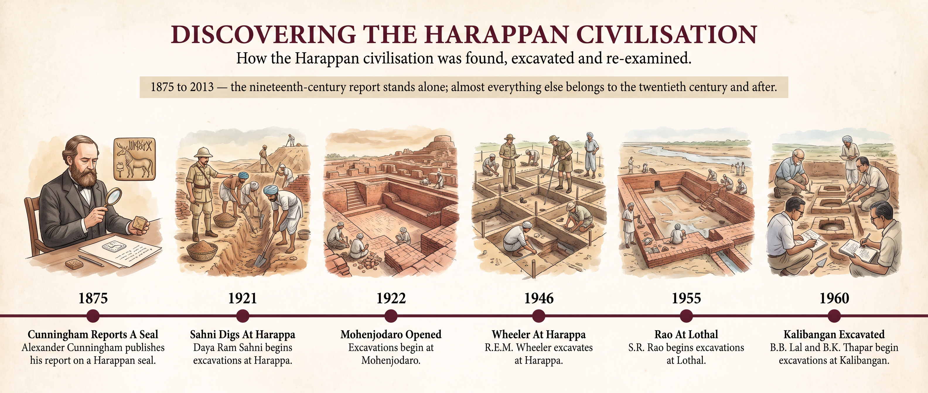
Fig. 1.37 – Major Developments In Harappan Archaeology.
What The Evidence Cannot Tell Us
The Harappans left no voice of their own. Their script cannot be read, so not one Harappan has ever told us a name, a law, a prayer or a complaint — everything in this chapter has been reconstructed from things, by people who came four thousand years later.
The things themselves are a biased sample. Stone, terracotta and metal survived; cloth, leather, wood and reeds rotted away, and with them whole crafts and most of daily life. Whatever was valuable was recycled or hoarded, so the intact treasures we display are accidents, not typical possessions.
And the silences run deepest where the questions are largest. We do not know who ruled, whether the Great Bath was sacred, how many people could write, or what the terracotta female figurines were for. Very few scholars have even asked what women’s work and women’s lives were like in this civilisation. That silence is not in the evidence. It is in us.
1.13 NCERT Questions
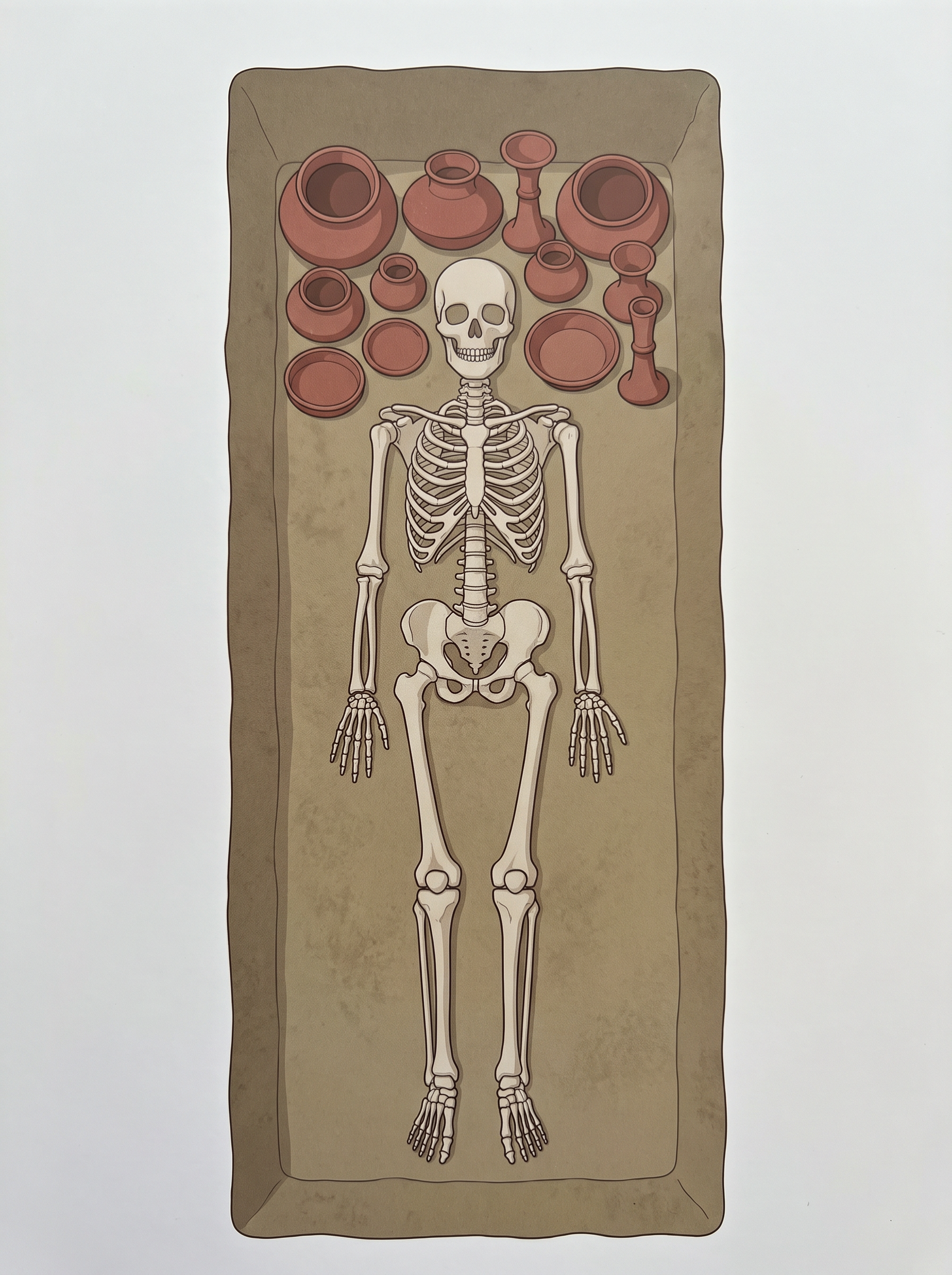
Fig. 1.38 – A Harappan burial.
List the items of food available to people in Harappan cities. Identify the groups who would have provided these. (in about 100-150 words)
How do archaeologists trace socio-economic differences in Harappan society? What are the differences that they notice? (in about 100-150 words)
Would you agree that the drainage system in Harappan cities indicates town planning? Give reasons for your answer. (in about 100-150 words)
List the materials used to make beads in the Harappan civilisation. Describe the process by which any one kind of bead was made. (in about 100-150 words)
Look at Fig. 1.38 and describe what you see. How is the body placed? What are the objects placed near it? Are there any artefacts on the body? Do these indicate the sex of the skeleton? (in about 100-150 words)
Describe some of the distinctive features of Mohenjodaro. (in about 500 words)
List the raw materials required for craft production in the Harappan civilisation and discuss how these might have been obtained. (in about 500 words)
Discuss how archaeologists reconstruct the past. (in about 500 words)
Discuss the functions that may have been performed by rulers in Harappan society. (in about 500 words)
On Map 1, use a pencil to circle sites where evidence of agriculture has been recovered. Mark an X against sites where there is evidence of craft production, and R against sites where raw materials were found.
1.14 Check Your Concepts
Explain the difference between a seal and a sealing. Using both, describe how a bag of goods sent from one settlement to another could reach its destination with the sender identified and the contents untouched.
Harappan weights were made of chert, were generally cubical, and carried no markings at all. The lower denominations were binary (1, 2, 4, 8, 16, 32) and the higher ones decimal (160, 200, 320, 640). What does such a system tell us about exchange among the Harappans, and why does an unmarked weight need no number written on it?
Read Source 1 again. State one thing about Harappan life that the saddle querns can genuinely establish, and one thing in Mackay’s account that comes from his own kitchen rather than from the stones. Why must an archaeologist be careful with present-day analogies?
Look at Fig. 1.26. Explain why archaeologists gave this statue the name ‘priest-king’, and state what evidence would be needed before we could say that the man shown actually held political power.
Climatic change, deforestation, floods, shifting rivers and overuse of the landscape have all been suggested as causes for the end of the Harappan civilisation. Explain why none of these, by itself, is a satisfactory explanation. What does the shift from a standardised weight system to local weights suggest about what came to an end?
In Source 3, Wheeler argues that Mohenjodaro was destroyed by a massacre, while Dales rejects this. Set out what a massacre would have left behind in the ground, and explain how Dales used those absences to answer Wheeler.
Organic materials such as cloth, leather, wood and reeds decay, while valuable objects were usually recycled or hidden in hoards. Explain how these two facts together bias the picture of Harappan life that archaeologists are able to build, and give one example of something we therefore know very little about.