Chapter 7: An Imperial Capital: Vijayanagara
In 1800, an engineer of the English East India Company rode into a stretch of broken granite on the banks of the Tungabhadra, in what is today northern Karnataka. His name was Colin Mackenzie. He had come to survey, to measure and to draw, and what lay in front of him was a field of ruin — collapsed walls, empty gateways, temple pillars standing in scrub, all of it spread across kilometres of rock and river.
He could measure the stones. He could not read them. A ruin does not announce who built it, or when, or why it was left empty. So Mackenzie did the one thing a surveyor’s instruments could not do for him: he asked the people who lived there.
The priests of the Virupaksha temple and of the shrine of Pampadevi told him what they had always known. The place was Hampi, named after Pampadevi, their local mother goddess. And they carried, in memory, fragments of a city that had once stood here — a city sacked in 1565 and abandoned soon after, its stones sitting in silence for well over two hundred years.
From that meeting between a colonial map-maker and a living local memory, the modern study of Vijayanagara begins. Almost everything historians now say about this empire was assembled, piece by piece, from evidence that had to be found, questioned and fitted together.
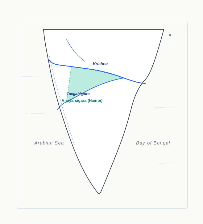
Fig. 7.0 – Vijayanagara in the Krishna–Tungabhadra doab.
7.1 The Discovery Of Hampi
A City And An Empire
Vijayanagara means ‘city of victory’. The name belonged to two things at once — a city, and the empire ruled from it. The empire was founded in the fourteenth century. At its height it stretched from the river Krishna in the north to the extreme south of the peninsula.
In 1565 the city was sacked, and soon afterwards it was deserted. It fell into ruin in the seventeenth and eighteenth centuries. But it did not disappear from human memory. The people living in the Krishna–Tungabhadra doab — the tongue of land lying between two rivers — went on remembering it.
They remembered it as Hampi. The name comes from Pampadevi, the local mother goddess. Those oral traditions, combined with archaeological finds, monuments, inscriptions and other records, helped scholars to rediscover the Vijayanagara Empire.
Notice how many different kinds of evidence sit in that last sentence. No single one of them could have rebuilt the picture on its own. This is worth holding on to as you read the chapter: everything the book tells you about Vijayanagara has been assembled from stone, from writing, and from what people remembered.
Fig. 7.1 shows one of the plainest and most massive pieces of that evidence — a stretch of the stone wall built around the city.
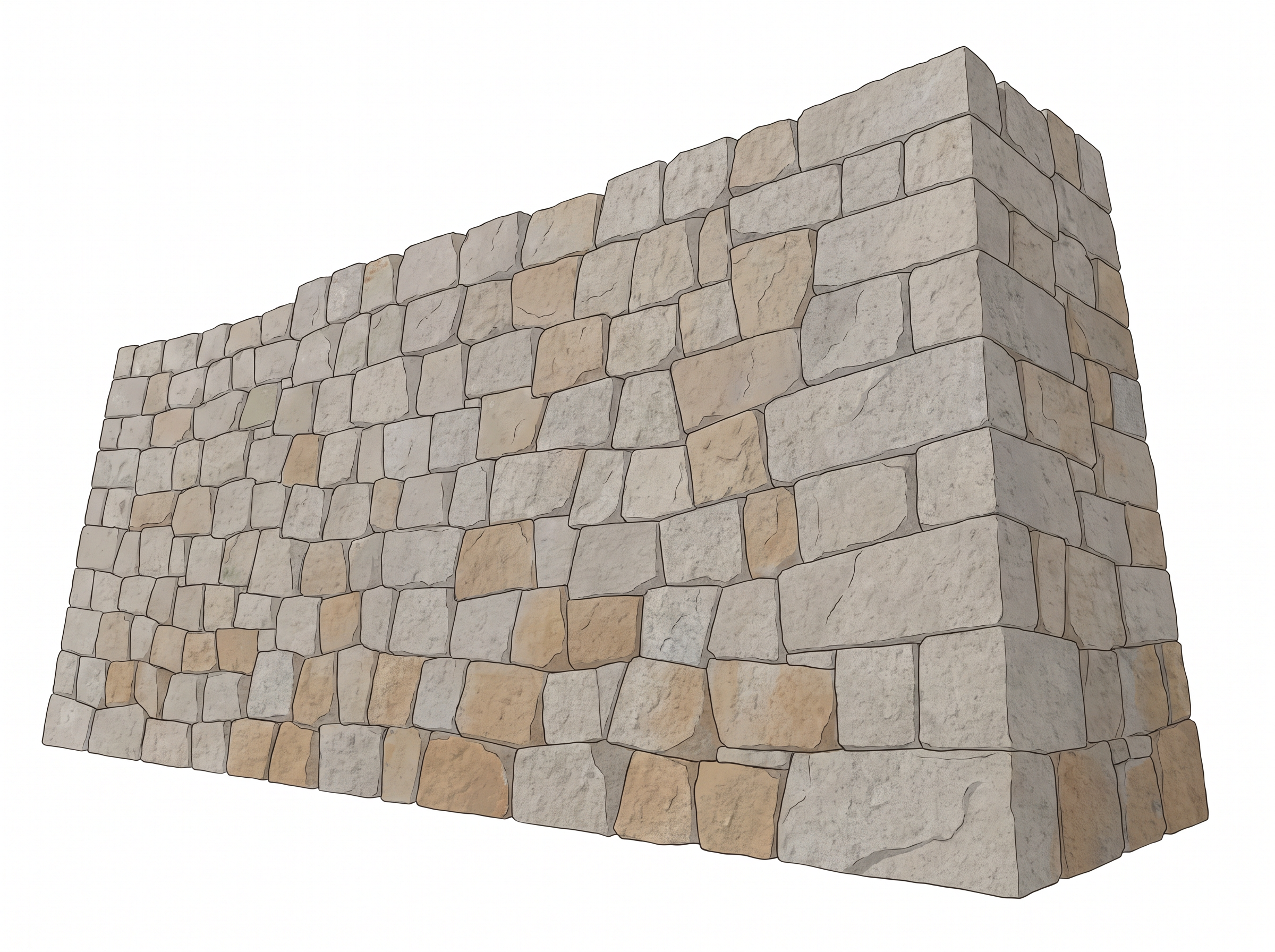
Fig. 7.1 – Fortification wall at Vijayanagara.
The Surveyor At The Ruins
The ruins at Hampi were brought to light in 1800 by an engineer and antiquarian named Colonel Colin Mackenzie — an antiquarian being someone who collects and studies the remains and records of the past. He was an employee of the English East India Company, the trading company that by 1800 had become a ruling power over large parts of the subcontinent.
Mackenzie prepared the first survey map of the site. A survey map fixes what is actually there — where a wall runs, how far one gateway stands from another — and it is the beginning of any serious study of a ruined city.
Much of the initial information he received was based on the memories of the priests of the Virupaksha temple and the shrine of Pampadevi. This is a point worth pausing on. The first modern account of Vijayanagara rested on what local people still remembered, and on nothing else.
More Kinds Of Evidence Arrive
The evidence then grew, and it grew in layers. As early as 1836, epigraphists began collecting several dozen inscriptions found at this and other temples at Hampi. Epigraphy is the study of inscriptions — writing cut into stone or metal, which is exactly why so much of it survives when paper and cloth do not.
From 1856, photographers began to record the monuments. A photograph could be carried away and studied at leisure, by scholars who had never stood at the site. That changed what could be compared, argued over and published.
Historians then set out to reconstruct the history of the city and the empire. They collated information from these sources with the accounts of foreign travellers, and with other literature written in Telugu, Kannada, Tamil and Sanskrit.
Reading The Man Who Made The Map
Mackenzie was not a neutral recorder, and the book does not pretend that he was. He worked for a colonial government, and he said plainly what he thought the study of India’s past was for. Source 1 gives his own words. Read it as evidence about Mackenzie, not only as evidence about Vijayanagara.
Two things stand out. First, Mackenzie’s judgement on the south’s own past is a colonial official’s judgement — he treats British rule as a benign improvement on what came before, and that opinion is his, not a finding of research. Second, he is candid about the use of knowledge: understanding India’s institutions, laws and customs would make the colony easier to govern.
That does not make his survey worthless. His map, and the local histories he collected, are still used. But it does tell us why the work was funded, and which questions were asked. A record made to help a state rule tends to notice what a state can use.
The Painting Of The Surveyor
Fig. 7.2 shows Mackenzie standing among the men who made his work possible. Look at where each figure has been placed, and how each has been dressed and lit.

Fig. 7.2 – Colin Mackenzie and his assistants.
The named men in that painting were not servants of the survey alone. They were scholars in their own languages and traditions, and without them Mackenzie could not have read a single inscription or understood a single local history. Whether the painting lets you see them that way is the question the artist has already answered for you.
7.2 Rayas, Nayakas And Sultans
Two Brothers And A Founding Date
According to tradition and epigraphic evidence, two brothers, Harihara and Bukka, founded the Vijayanagara Empire in 1336. That single sentence carries two very different kinds of proof, and it is worth separating them. Tradition is what people later said had happened. Epigraphic evidence is what was cut into stone at the time, or nearer to the time.
This empire included, within its fluctuating frontiers, peoples who spoke different languages and followed different religious traditions. ‘Fluctuating’ is the important word. The empire’s edges moved with war, alliance and defeat, so a line drawn on a map shows you one moment only, not a fixed shape.
While historians use the term Vijayanagara Empire, contemporaries described it as the karnataka samrajyamu. Names matter here. The word the people of the time used is not the word our textbooks use, and the difference is a reminder that our categories are often fixed on the past long afterwards.
Rivals On The Northern Frontier
On their northern frontier, the Vijayanagara kings competed with contemporary rulers. Among these were the Sultans of the Deccan — the rulers of the states of the peninsular plateau to the north — and the Gajapati rulers of Orissa, on the eastern coast.
What were they competing for? Two prizes. The first was control of the fertile river valleys, which fed people and produced revenue. The second was the resources generated by lucrative overseas trade, which came in through the ports and enriched whoever controlled them.
The names these rulers gave one another are themselves a piece of evidence. Gajapati literally means lord of elephants. It was the name of a ruling lineage that was very powerful in Orissa in the fifteenth century. In the popular traditions of Vijayanagara the Deccan Sultans are termed ashvapati or lord of horses, and the rayas are called narapati or lord of men.
Rivals Who Borrowed From Each Other
Competition was not the whole story. At the same time, interaction between these states led to the sharing of ideas, especially in the field of architecture. The rulers of Vijayanagara borrowed concepts and building techniques, which they then developed further.
Hold on to that sentence, because it complicates the easy picture. These states fought each other, and they also learned from each other. Rulers who met on a battlefield could still admire, and copy, the way an enemy built an arch.
Building On Older Traditions
Some of the areas that were incorporated within the empire had witnessed the development of powerful states of their own. Two examples stand out: the Cholas in Tamil Nadu, and the Hoysalas in Karnataka.
Ruling elites in these areas had extended patronage to elaborate temples. Patronage means the support a ruler or a wealthy person gives to a temple, an artist or a scholar — land, money, protection — usually in return for prestige. The Brihadishvara temple at Thanjavur and the Chennakeshava temple at Belur were built and maintained with such support.
Fig. 7.3 shows the gopuram, or gateway, of the Brihadishvara temple at Thanjavur. Look at its height, and at how much sculpted detail has been carried up its face.
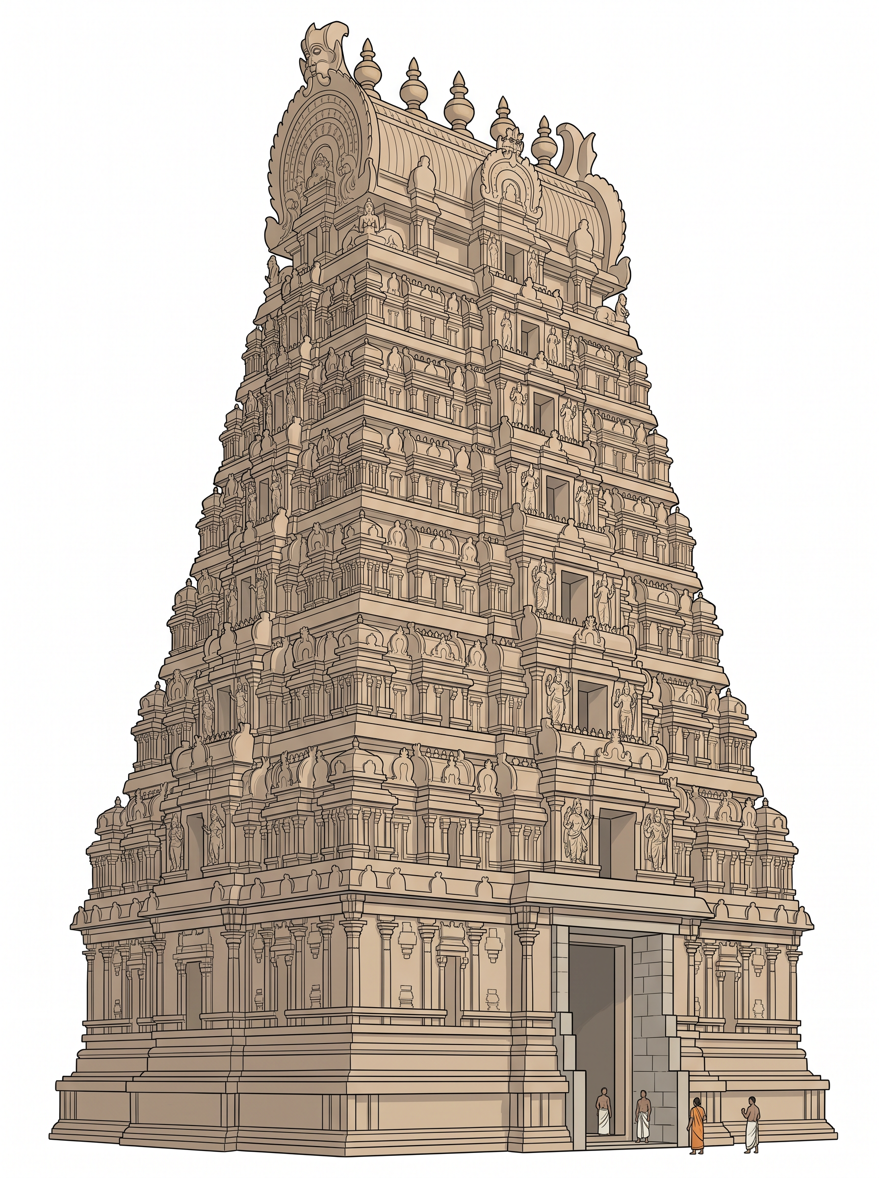
Fig. 7.3 – Gateway of the Brihadishvara temple, Thanjavur.
The rulers of Vijayanagara, who called themselves rayas, built on these traditions. They carried them, as we will see, literally to new heights — the gateways they raised would come to tower over the shrines they guarded.
So the rayas drew on two streams at once. From the north came building ideas learned through rivalry with the Sultans. From within their own territories came the long southern tradition of temple building, inherited from states such as those of the Cholas and the Hoysalas. The imperial style was made out of both.
7.2.1 Kings And Traders
Why A Kingdom Needed Foreign Horses
Warfare during these times depended upon effective cavalry. An army that could not move fast, strike and wheel away lost battles to one that could. And cavalry needs horses — a great many of them, of the right kind, replaced constantly.
So the import of horses from Arabia and Central Asia was very important for rival kingdoms. Notice the word ‘rival’. Vijayanagara was not the only state that needed horses; the Deccan Sultans and the Gajapatis needed them too. Whoever could buy more, and buy better, gained an advantage in the field.
This trade was initially controlled by Arab traders, who carried horses across the sea to the ports of the western coast. Local communities of merchants known as kudirai chettis, or horse merchants, also participated in these exchanges. The horses were foreign; the men who moved and sold them within the peninsula were not.
The Portuguese Arrive
From 1498 other actors appeared on the scene. These were the Portuguese, who arrived on the west coast of the subcontinent and attempted to establish trading and military stations — that is, fortified posts from which they could both trade and fight.
Their superior military technology, especially the use of muskets, enabled them to become important players in the tangled politics of the period. A musket is a long gun fired from the shoulder, and in the early sixteenth century very few forces in the peninsula had them.
‘Tangled’ is a fair word for that politics. The Portuguese were not simply outsiders arriving at the edge of somebody else’s story. They became one more power among the rival kingdoms and Sultanates, choosing sides, selling arms and horses, and taking their profit from the competition.
A City That Bought And Sold
Vijayanagara was also noted for its markets dealing in spices, textiles and precious stones. These were not everyday goods. They were the kind of goods that travel long distances precisely because they are valuable in small quantities.
Trade was often regarded as a status symbol for such cities. A great city boasted of a wealthy population that demanded high-value exotic goods, especially precious stones and jewellery. In other words, the market was not only an economic fact; it was an advertisement of what the city was.
And it paid. The revenue derived from trade in turn contributed significantly to the prosperity of the state. A ruler who protected merchants was protecting his own income.
A King Writes About Traders
That last point is not a modern historian’s guess. We can read it in the words of a Vijayanagara king himself. Krishnadeva Raya, who ruled from 1509 to 1529, was the most famous ruler of Vijayanagara, and he composed a work on statecraft in Telugu — a book of advice on how to rule — known as the Amuktamalyada. Source 2 gives what he wrote about traders.
Read the last sentence again, because it gives the game away. The king’s concern is not merely that goods should arrive. It is that they should not go to his enemies. Horses and elephants are war material, and a merchant well treated at Vijayanagara is a merchant not selling to Bijapur.
The rest of the advice follows the same hard logic. Improve harbours, so that ships come. Care for shipwrecked and sick foreign sailors, so that sailing here is safe. Give the merchants a daily audience, gifts and decent profits, so that they stay loyal. Generosity, here, is policy.
There is a whole political economy compressed into that chain. A distant breeder, a sea route, a foreign trader, a local merchant, a royal favour, and finally a cavalryman in the field. Break the chain at any point, and an army is weakened at the point where it can least afford it.
7.2.2 The Apogee And Decline Of The Empire
Who Could Claim The Throne
Within the polity — that is, within the political system of the empire — claimants to power included members of the ruling lineage as well as military commanders. That is an unstable arrangement, and it shaped the whole history of the empire. A throne that a successful general could reach was a throne that a successful general might take.
That is exactly what happened, twice. The first dynasty, or line of rulers from a single family, was known as the Sangama dynasty, and it exercised control till 1485. They were supplanted by the Saluvas, military commanders, who remained in power till 1503, when they were replaced by the Tuluvas. Krishnadeva Raya belonged to the Tuluva dynasty.
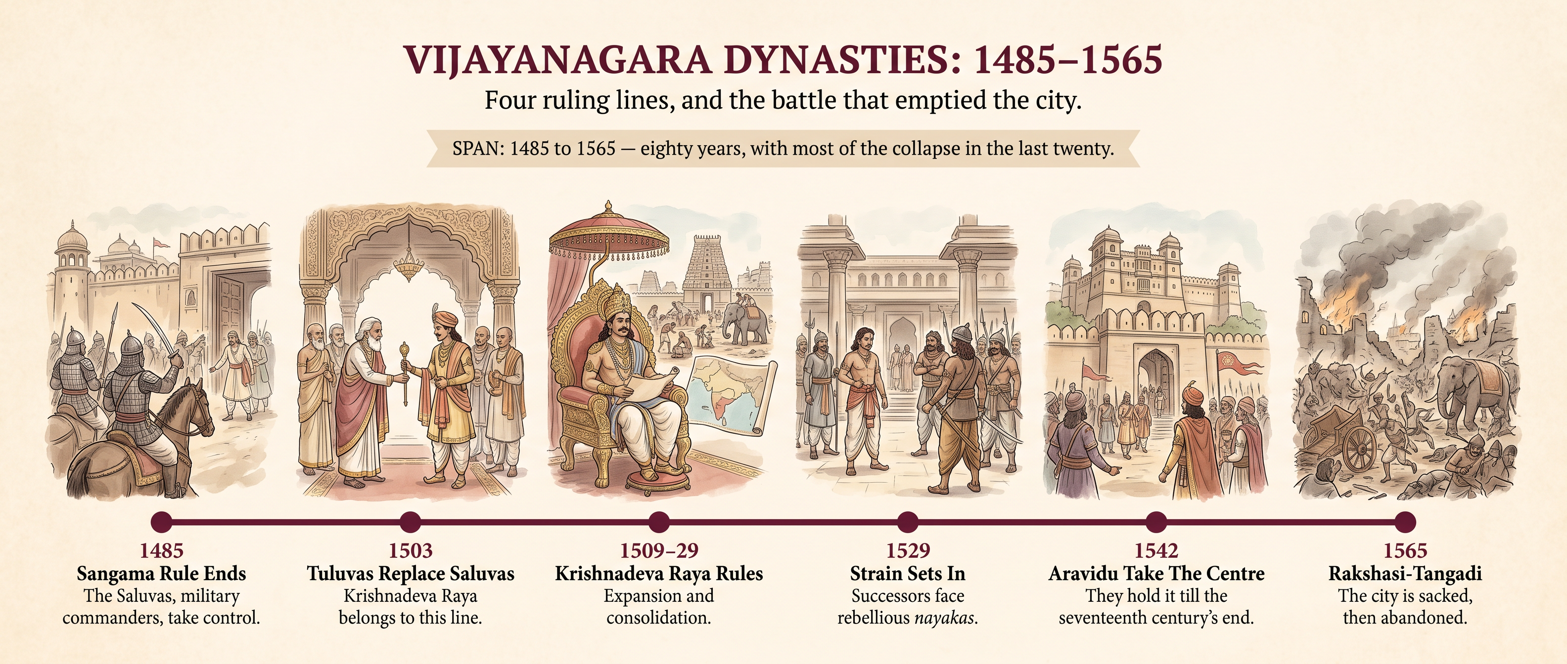
Fig. 7.4 – Dynasties and the fall.
The Apogee: Krishnadeva Raya
Krishnadeva Raya’s rule was characterised by expansion and consolidation. The two words are worth separating: expansion means taking new territory, consolidation means holding what you have taken and making it work.
The expansion is dated. The land between the Tungabhadra and Krishna rivers — the Raichur doab — was acquired in 1512. The rulers of Orissa were subdued in 1514. Severe defeats were inflicted on the Sultan of Bijapur in 1520.
Although the kingdom remained in a constant state of military preparedness, it flourished under conditions of unparalleled peace and prosperity. Read that sentence slowly, because it holds a contradiction that was real. The army never stood down; and yet, inside the frontiers, this was the calmest and richest stretch the empire knew.
Krishnadeva Raya is credited with building some fine temples and with adding impressive gopurams to many important south Indian temples. He also founded a suburban township near Vijayanagara called Nagalapuram, after his mother.
One more fact about this reign matters more than it looks. Some of the most detailed descriptions of Vijayanagara come from his time or just after. When you read a traveller praising the size, the water and the markets of the city, you are usually reading about the city at its height — not about the city across its whole history.
The Decline Begins
Strain began to show within the imperial structure following Krishnadeva Raya’s death in 1529. His successors were troubled by rebellious nayakas, or military chiefs — the men who held forts and armed followers, and whom you will meet properly in the next section.
By 1542, control at the centre had shifted to yet another ruling lineage, that of the Aravidu, which remained in power till the end of the seventeenth century. So within thirteen years of Krishnadeva Raya’s death, the family that had produced him had lost the centre.
During this period, as indeed earlier, the military ambitions of the rulers of Vijayanagara as well as those of the Deccan Sultanates resulted in shifting alignments. Alliances formed, broke and reformed. No enmity was permanent, and no friendship was either.
1565: Rakshasi-Tangadi
Eventually this led to an alliance of the Sultanates against Vijayanagara. In 1565, Rama Raya — the chief minister of Vijayanagara, and therefore the man who actually ran the state — led the army into battle at Rakshasi-Tangadi, also known as Talikota.
There his forces were routed by the combined armies of Bijapur, Ahmadnagar and Golconda, three of the Deccan Sultanates. The victorious armies sacked the city of Vijayanagara. The city was totally abandoned within a few years.
The empire itself did not end at once. The focus now shifted to the east, where the Aravidu dynasty ruled from Penukonda and later from Chandragiri, near Tirupati. But the capital never came back to life, and the ruins Colin Mackenzie walked into more than two centuries later were made in those few years.
Enemies, But Not Always
It would be easy — and wrong — to read 1565 as the end point of a permanent religious war. The chapter is careful here, and so should you be.
Although the armies of the Sultans were responsible for the destruction of the city of Vijayanagara, relations between the Sultans and the rayas were not always or inevitably hostile, in spite of religious differences. The evidence for that sits in what these rulers actually did.
Krishnadeva Raya, for example, supported some claimants to power in the Sultanates, and took pride in the title ‘establisher of the Yavana kingdom’. Similarly, the Sultan of Bijapur intervened to resolve succession disputes in Vijayanagara following the death of Krishnadeva Raya. In fact the Vijayanagara kings were keen to ensure the stability of the Sultanates, and vice versa.
So what finally brought the Sultans together? It was the adventurous policy of Rama Raya, who tried to play off one Sultan against another. That, and not an inevitable religious hostility, led the Sultans to combine and decisively defeat him.
Seeing It On The Map
Fig. 7.5 shows the region across these centuries. Find Vijayanagara on the Tungabhadra. Then find Bijapur, Ahmadnagar and Golconda to the north, and Chandragiri to the south-east — the place to which the empire’s centre retreated after 1565.
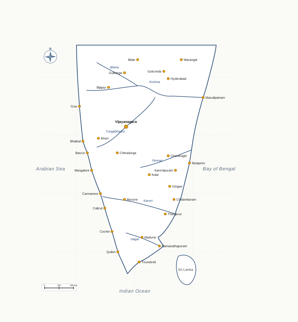
Fig. 7.5 – South India, fourteenth to eighteenth century.
7.2.3 The Rayas And The Nayakas
Chiefs With Forts And Followers
Among those who exercised power in the empire were military chiefs who usually controlled forts and had armed supporters. Two possessions, then: a fort, and men. Between them they made a chief someone a king had to reckon with.
These chiefs often moved from one area to another, and in many cases they were accompanied by peasants looking for fertile land on which to settle. That detail is easy to skim past, and it should not be backward. A chief on the move was not only an army on the move; he was a settlement on the move, carrying cultivators with him into new land.
These chiefs were known as nayakas, and they usually spoke Telugu or Kannada. Many nayakas submitted to the authority of the kings of Vijayanagara. But they often rebelled, and had to be subdued by military action.
So the relationship was never settled once and for all. Submission was a condition that had to be renewed, and a chief who submitted this year might rebel the next.
The Amara-Nayaka System
The amara-nayaka system was a major political innovation of the Vijayanagara Empire. It is likely that many features of this system were derived from the iqta system of the Delhi Sultanate, in which commanders were assigned territories whose revenues supported them and the troops they maintained.
The amara-nayakas were military commanders who were given territories to govern by the raya. Notice what a king was actually handing over: not a salary, but a piece of land and the right to take from it.
They collected taxes and other dues from the peasants, craftspersons and traders in the area. They retained part of the revenue for personal use, and part for maintaining a stipulated contingent of horses and elephants — that is, a fixed number, agreed in advance, which the commander had to keep ready.
These contingents provided the Vijayanagara kings with an effective fighting force, with which they brought the entire southern peninsula under their control. Some of the revenue was also used for the maintenance of temples and irrigation works. So the same stream of revenue paid for war, for worship and for water.
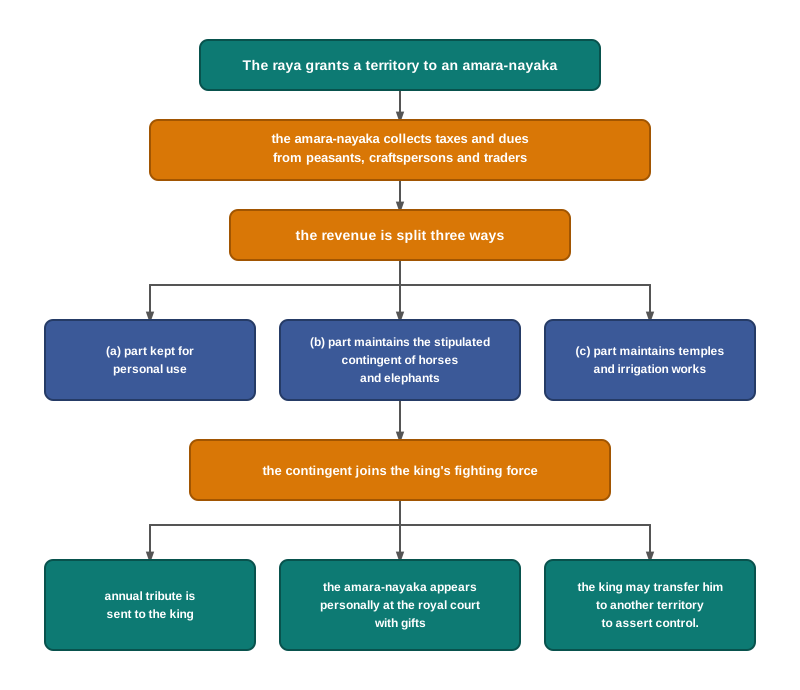
Fig. 7.6 – How the amara-nayaka system worked.
Loyalty, And Its Limits
The amara-nayakas sent tribute to the king annually — a payment made by a subordinate to a superior, as an acknowledgement of that superiority. They also personally appeared in the royal court with gifts to express their loyalty.
The appearance mattered as much as the payment. A man who comes in person, and is seen to come, has admitted before witnesses whose man he is.
Kings occasionally asserted their control over them by transferring them from one place to another. This was a shrewd device. A commander moved every few years cannot sink roots, build local alliances, or turn a granted territory into a family possession.
However, during the course of the seventeenth century, many of these nayakas established independent kingdoms. This hastened the collapse of the central imperial structure.
The honest answer is that both were true, at different moments. A system that made an empire could also unmake it, and the very features that gave the raya his armies gave the nayaka the means to do without him.
7.3 Vijayanagara: The Capital And Its Environs
Like most capitals, Vijayanagara was characterised by a distinctive physical layout and building style. A capital is never only a large town. It is the place where a ruler shows what his power is, in stone, in water and in space — and it can be read like a document, if you know how.
Fig. 7.7 gives you the plan of the city — a plan being a horizontal view, as if you were looking straight down from above. It is the single most useful page in this chapter, and you will keep coming back to it.
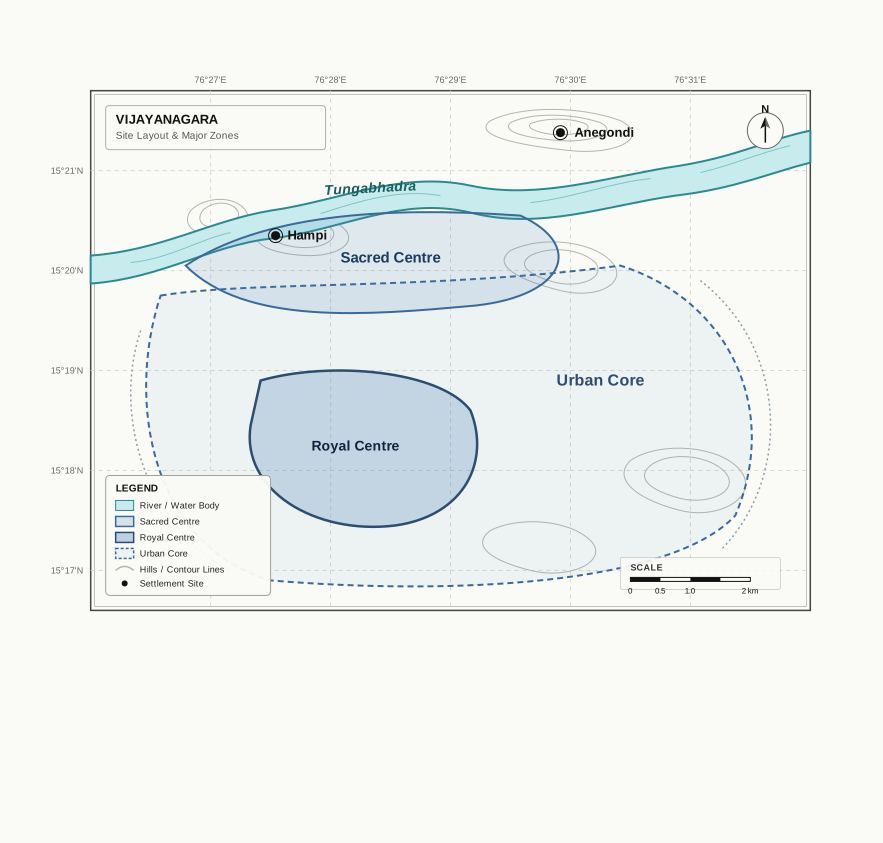
Fig. 7.7 – Plan of Vijayanagara.
Where The Information Comes From
Before we walk through the city, it is worth asking how anyone knows what stood where. Two very different bodies of evidence make this chapter possible, and each shows what the other hides.
The first is inscriptions. A large number of inscriptions of the kings of Vijayanagara and their nayakas have been recovered. These record donations to temples, and they describe important events. Cut into stone, meant to last, they are the state’s own record of what it wished to be remembered.
The second is the accounts of travellers, several of whom visited the city and wrote about it. In the fifteenth century came an Italian trader named Nicolo de Conti, an ambassador named Abdur Razzaq sent by the ruler of Persia — the region of present-day Iran — and a merchant named Afanasii Nikitin from Russia. In the sixteenth century came Duarte Barbosa, Domingo Paes and Fernao Nuniz from Portugal.
Each of these men was an outsider, and each had a reason to be there — trade, diplomacy, profit. That does not make them unreliable. It does mean that what struck them as remarkable tells us as much about them as about Vijayanagara.
Paes Climbs A Hill
Domingo Paes could not see the whole city at once, so he went up a hill to try. Source 3 is what he saw, and what he could not see.
Look at what Paes chooses to record. Not walls, not soldiers, not wealth — but greenery and water. Groves of trees inside the city, gardens attached to houses, conduits carrying water into the middle of it, lakes, and a palm-grove beside the king’s palace.
He notices them because they surprise him. A city stuffed with trees and running water was not what a sixteenth-century European expected a city to be, and the comparison he reaches for — Rome — is the largest thing he can think of from home.
And note his honesty about the limits of his own eyes. The city cannot all be seen from any one spot, because it lies between several ranges of hills. That single admission tells us something the plan in Fig. 7.7 confirms: this was a settlement wrapped around a landscape, not laid out on a flat field.
7.3.1 Water Resources
A City In A Dry Basin
The most striking feature about the location of Vijayanagara is the natural basin formed by the river Tungabhadra, which flows in a north-easterly direction. A basin, here, means a low bowl of land into which the water of a region drains.
The surrounding landscape is characterised by stunning granite hills that seem to form a girdle around the city. A number of streams flow down to the river from these rocky outcrops. Rock, river, and streams running off the rock — that is the raw material the builders of this city were given.
Now hold that against a second fact. This is one of the most arid zones of the peninsula. Arid means dry: rain is scarce, and when it comes, it runs off bare granite and is gone.
So the problem was not that there was no water. It was that the water would not stay. Everything the Vijayanagara engineers did with water follows from that single difficulty.
Catching The Water, Holding The Water
In almost all cases, embankments were built along these streams to create reservoirs of varying sizes. An embankment is a raised bank of earth and stone thrown across the path of running water, so that the water is stopped and pools behind it.
Because the zone was so dry, elaborate arrangements had to be made to store rainwater and conduct it to the city. Two verbs, and two different problems: storing the water where it falls, and then carrying it to where people actually lived.
The most important such tank — a large artificial reservoir, banked and held — was built in the early years of the fifteenth century, and is now called the Kamalapuram tank. Water from this tank not only irrigated fields nearby but was also conducted through a channel to the ‘royal centre’.
One of the most prominent waterworks to be seen among the ruins is the Hiriya canal. This canal drew water from a dam across the Tungabhadra, and irrigated the cultivated valley that separated the ‘sacred centre’ from the ‘urban core’. It was apparently built by the kings of the Sangama dynasty.
Notice that word, ‘apparently’. The canal is there, and it can be walked along. Who ordered it dug is a separate claim, and a weaker one.
Fig. 7.8 shows one piece of that system still standing — an aqueduct, a raised channel built to carry water across ground it could not otherwise cross.
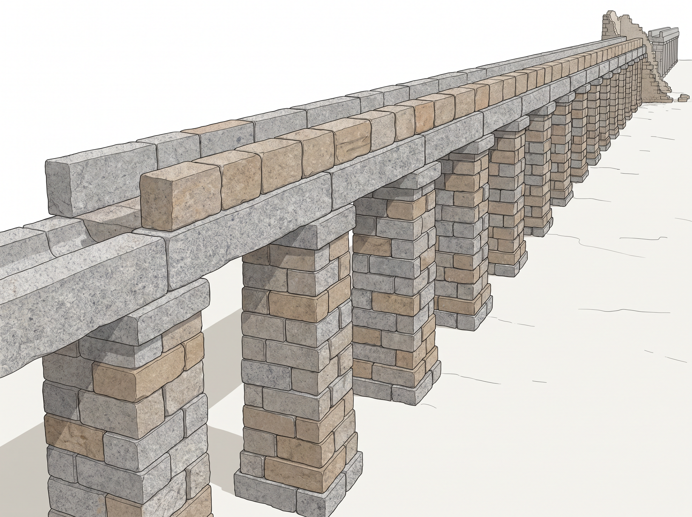
Fig. 7.8 – Aqueduct leading into the royal centre.
A Tank, As A Traveller Saw It Built
We even have a description of the making of one such tank, written by someone who had seen the work. Domingo Paes wrote about a tank constructed by Krishnadeva Raya. Read Source 4 for the engineering, and then for the labour.
The design, as Paes describes it, is exactly the design the ruins show. The tank is placed at the mouth of two hills, so that the run-off from both sides collects in one place. Extra water is piped in from more than three leagues away — roughly 15 kilometres — along the lower slopes of the range outside.
Then come the two sentences that change the tone. To make this tank, the king broke down a hill. And in the tank Paes saw so many people at work that there must have been, he thought, fifteen or twenty thousand men, looking like ants.
That is a description of power, not only of plumbing. A tank of this kind required a ruler who could command a hill to be levelled and a small city’s worth of workers to be assembled. Who those workers were, whether they came willingly, and what they were paid, Paes does not say — and no inscription tells us either.
7.3.2 Fortifications And Roads
Seven Lines Of Forts
Before we examine the different parts of the city in detail, let us look at what enclosed them all — the great fortress walls.
Abdur Razzaq, the ambassador sent by the ruler of Persia to Calicut, present-day Kozhikode on the Kerala coast, in the fifteenth century, was greatly impressed by the fortifications. He mentioned seven lines of forts. These encircled not only the city, but also its agricultural hinterland and its forests.
Stop at that last sentence, because it contains the whole surprise of this section. The walls did not merely wrap around houses and palaces. They took in the fields that fed the city, and the woods beyond them.
How The Walls Were Built
The outermost wall linked the hills surrounding the city. The builders were not fighting the landscape; they were using it, tying one granite hill to the next with masonry so that the rock itself became part of the defence.
The massive masonry construction was slightly tapered — thicker at the base, narrower at the top, which makes a wall far harder to topple. No mortar or cementing agent was employed anywhere in the construction.
That is remarkable, and it is not carelessness. The stone blocks were wedge shaped, which held them in place by their own weight and shape. The inner portion of the walls was of earth packed with rubble, and square or rectangular bastions — projecting towers from which defenders could fire along the face of the wall — projected outwards.
Walls Around Wheat, Not Just Around Houses
What was most significant about this fortification is that it enclosed agricultural tracts. We have two independent witnesses to it.
Abdur Razzaq noted that ‘between the first, second and the third walls there are cultivated fields, gardens and houses’. And Paes observed: ‘From this first circuit until you enter the city there is a great distance, in which are fields in which they sow rice and have many gardens and much water, in which water comes from two lakes.’
These statements have been corroborated by present-day archaeologists, who have also found evidence of an agricultural tract between the sacred centre and the urban core. This tract was serviced by an elaborate canal system drawing water from the Tungabhadra.
Two travellers, writing a century apart, and the spade: three separate kinds of evidence pointing the same way. When they agree like this, a historian’s confidence rises sharply.
Why Enclose The Fields?
Why do you think agricultural tracts were incorporated within the fortified area? The answer lies in how wars were actually fought.
Often, the objective of medieval sieges was to starve the defenders into submission. An attacker who could not break a wall could simply sit outside it and wait. These sieges could last for several months, and sometimes even years.
Normally, rulers tried to prepare for such situations by building large granaries within fortified areas — storing grain in advance, and hoping it would outlast the enemy’s patience. The rulers of Vijayanagara adopted a more expensive and elaborate strategy: they protected the agricultural belt itself.
Think about what that means. A granary holds a fixed quantity of grain, and when it is empty, it is empty. A protected field goes on producing. It cost far more to wall in, but it did not run out.
Walls Within Walls
The defence did not stop at the outer circuit. A second line of fortification went round the inner core of the urban complex. A third line surrounded the royal centre. And within that royal centre, each set of major buildings was surrounded by its own high walls.
So the city was built as a series of shells, one inside another. An attacker who broke the outermost wall had not taken the city; he had only reached the next wall. The closer you came to the king, the more walls you had passed — and the more obvious it was who lived at the centre.
Gates, Arches And A Borrowed Style
The fort was entered through well-guarded gates, which linked the city to the major roads. Gateways were distinctive architectural features that often defined the structures to which they regulated access. A gate says, before you pass it, what kind of place you are entering.
Look now at Fig. 7.9 and Fig. 7.10 together. One is a gateway in the fortification wall. The other is a gopuram, a temple gateway.
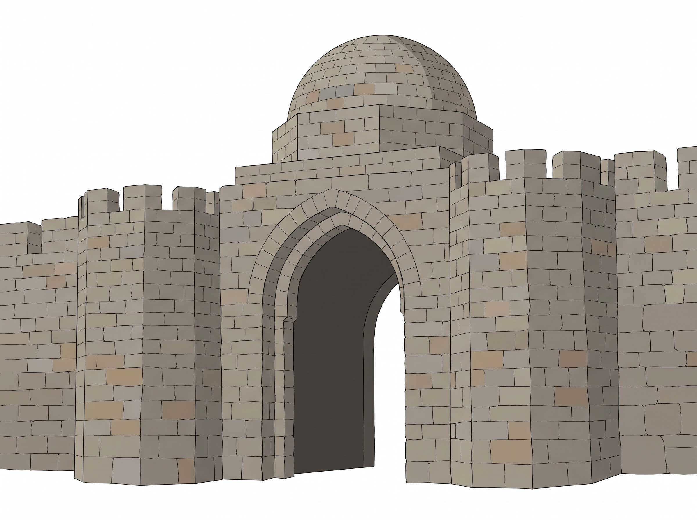
Fig. 7.9 – Gateway in the fortification wall.
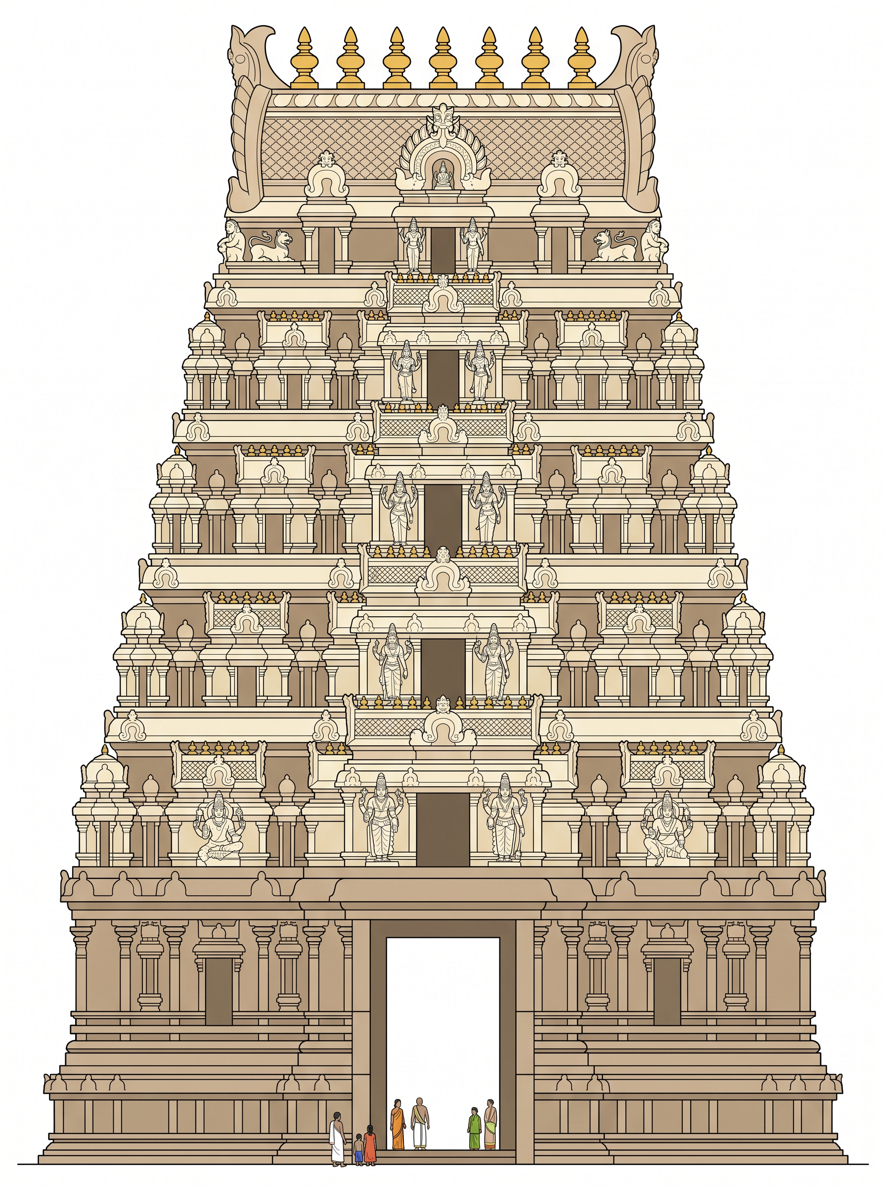
Fig. 7.10 – A Vijayanagara temple gopuram.
The arch on the gateway leading into the fortified settlement, as well as the dome over the gate in Fig. 7.9, are regarded as typical features of the architecture introduced by the Turkish Sultans. Art historians refer to this style as Indo-Islamic, as it grew continually through interaction with local building practices in different regions.
That last clause is the important one. Indo-Islamic is not a style that arrived finished and was simply copied. It kept changing as it met the ways of building already present in each region — and the rulers of Vijayanagara, who fought the Deccan Sultans, were among those who used it.
Finding The Roads
Archaeologists have studied the roads within the city and those leading out from it. A road, unlike a wall, rarely survives as a road. It has to be found.
These have been identified by tracing paths through gateways, as well as by finds of pavements. If a gate stands here, something led up to it; if a stretch of paving is dug up there, feet and carts once went over it.
Roads generally wound around through the valleys, avoiding rocky terrain — the same landscape that shaped the water system shaped the way people moved. And some of the most important roads extended from temple gateways, and were lined by bazaars.
That is a small sentence with a large implication. The busiest streets of the city ran out of its temples, and were full of shops. Worship, movement and trade shared the same stretch of ground.
7.3.3 The Urban Core
The Missing Houses
Moving along the roads leading into the urban core, there is relatively little archaeological evidence of the houses of ordinary people. Most of the city’s population lived here — and it is precisely their homes that the excavations cannot find.
This is one of the great, honest gaps in the chapter, and it is worth naming early. The stone that survives is the stone that kings and gods were given. What ordinary people lived in has largely gone.
We do have a description, though. The sixteenth-century Portuguese traveller Barbosa wrote about these houses, which have not survived: ‘The other houses of the people are thatched, but nonetheless well built and arranged according to occupations, in long streets with many open places.’
Read what he actually says, because he is careful. Thatched — and therefore perishable. But well built. Arranged by occupation, so that weavers lived among weavers and smiths among smiths. Set in long streets, with plenty of open ground between them.
What The Shards Say
Archaeologists have found fine Chinese porcelain in some areas, including in the north-eastern corner of the urban core, and suggest that these areas may have been occupied by rich traders. A shard is a broken piece of pottery, and it is one of the archaeologist’s most useful finds, because pottery breaks but does not rot.
This was also the Muslim residential quarter. Tombs and mosques located here have distinctive functions, yet their architecture resembles that of the mandapas — the pillared pavilions — found in the temples of Hampi.
That is a striking observation, and it cuts against a lazy assumption. A mosque and a temple served different purposes, yet the builders in this quarter were working with the same local repertoire of pillars and pavilions.
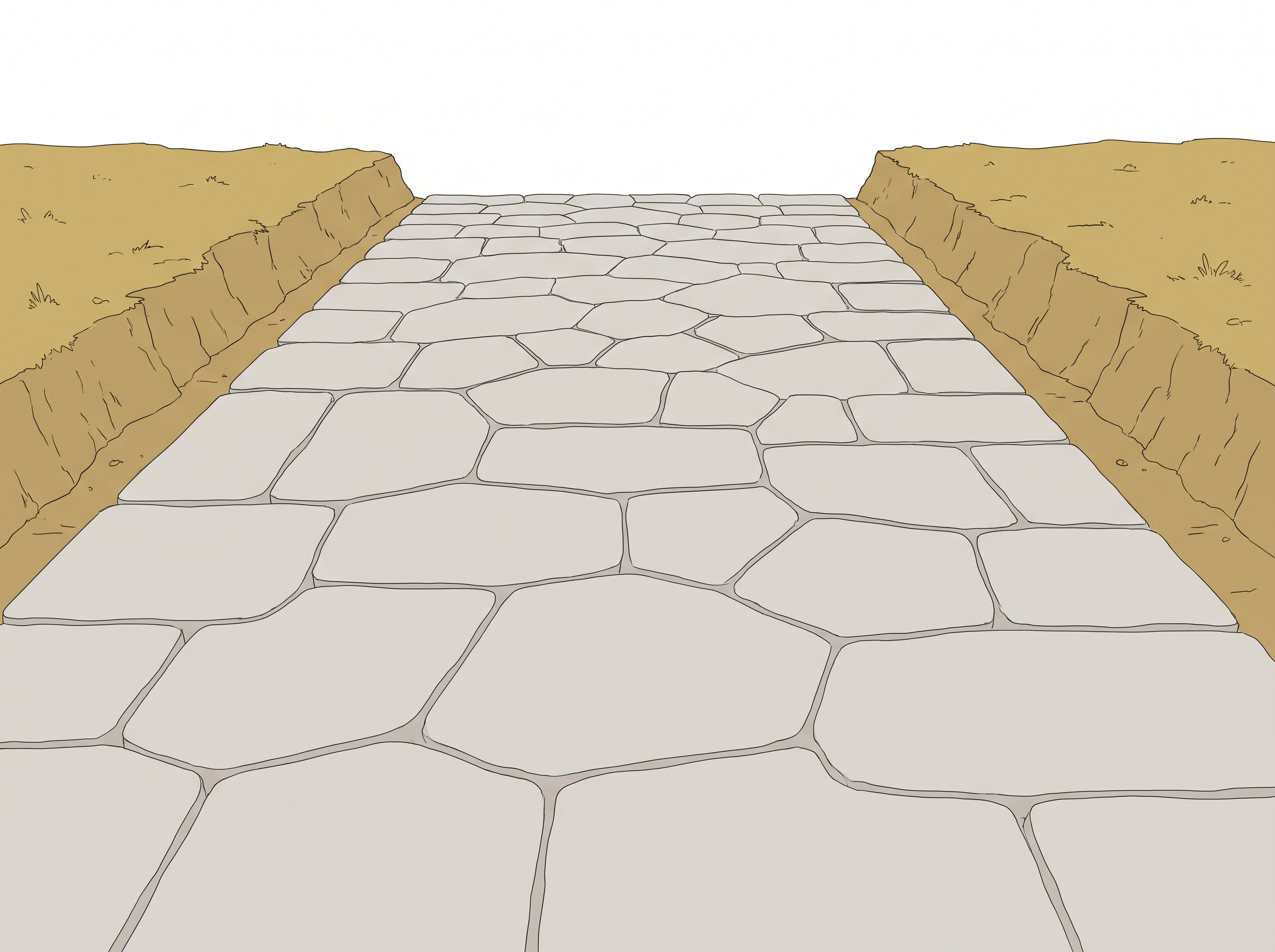
Fig. 7.11 – Part of an excavated pavement.
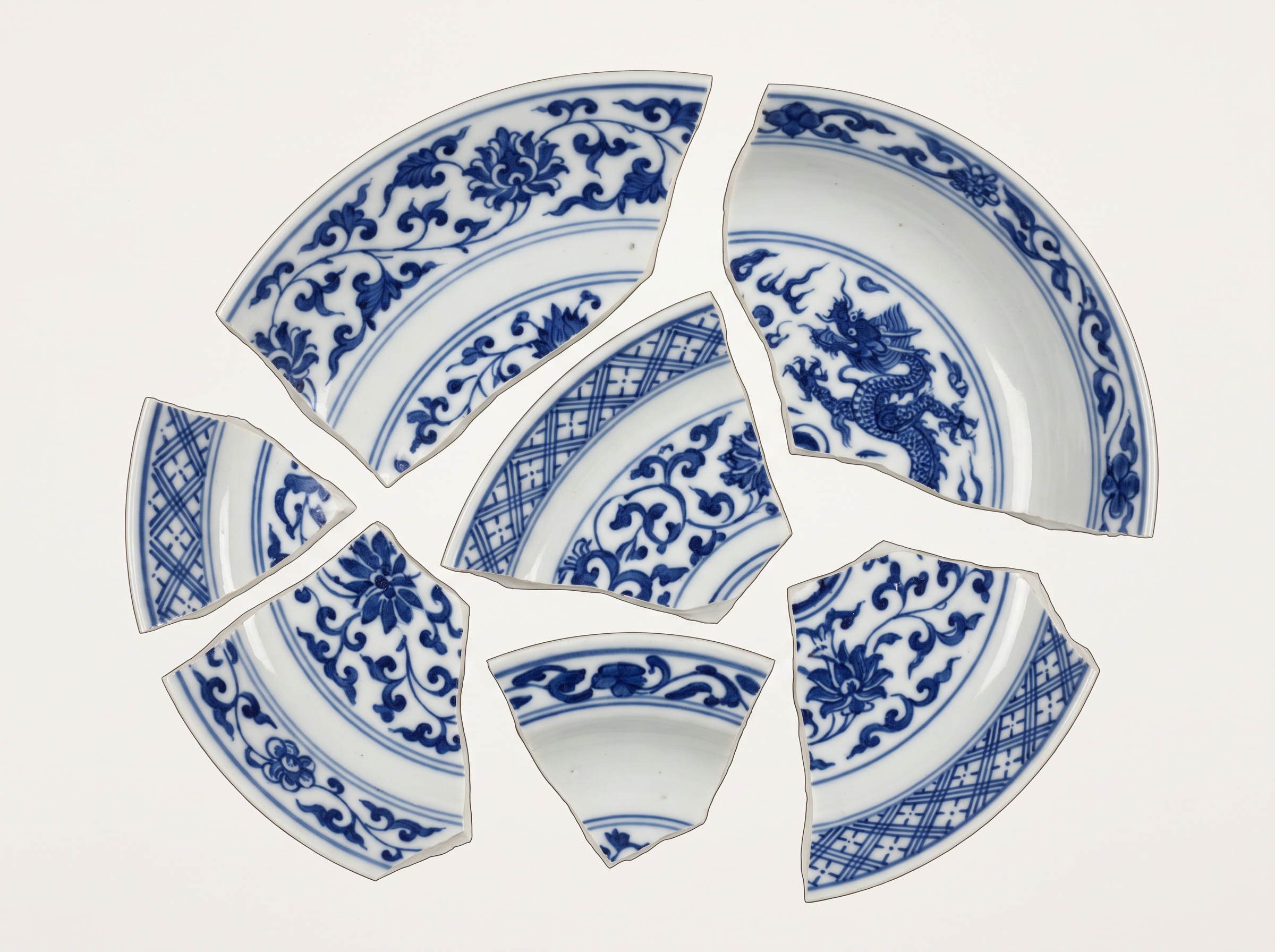
Fig. 7.12 – Shards of Chinese porcelain.
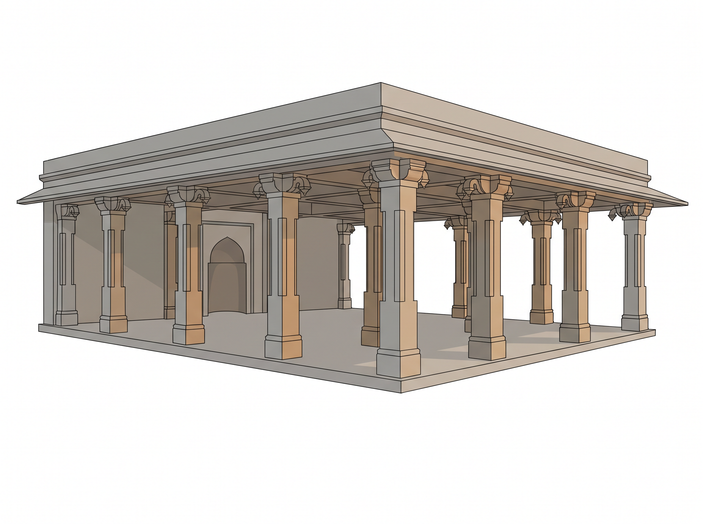
Fig. 7.13 – A mosque in Vijayanagara.
Many Shrines, Many Communities
Field surveys indicate that the entire area was dotted with numerous shrines and small temples. This points to the prevalence of a variety of cults, perhaps supported by different communities.
A cult, in this sense, simply means the worship of a particular deity, with its own practices and its own following. Many small shrines, scattered widely, suggest many such followings living side by side — not one official religion imposed from above.
The surveys also indicate that wells, rainwater tanks, as well as temple tanks, may have served as sources of water to the ordinary town dwellers. The great canals and reservoirs you met in the last section watered fields and the royal centre; ordinary households, it seems, drew from what was nearer to hand.
7.4 The Royal Centre
The royal centre was located in the south-western part of the settlement. Turn back to the plan in Fig. 7.14 and find it, because everything in this section sits inside that corner of the city.
Temples Inside The King’s Quarter
Although it is designated a royal centre, it included over 60 temples. That number should stop you. Sixty temples is not an ornament; it is a policy.
Clearly, the patronage of temples and cults was important for rulers who were trying to establish and legitimise their authority — that is, to make their power look rightful, and not merely successful — through association with the divinities housed in the shrines.
A king who builds a shrine, and is seen at it, is making an argument about himself without saying a word. He is placing his rule next to something already accepted as sacred, and inviting people to accept the two together.
Thirty Complexes Called Palaces
About thirty building complexes have been identified as palaces. These are relatively large structures that do not seem to have been associated with ritual functions.
Notice how the identification is being made. It rests on two things: size, and the absence of anything that looks religious. That is reasonable — and it is also an inference, not a reading of a label.
One difference between these structures and temples is that the latter were constructed entirely of masonry, while the superstructure of the secular buildings — the non-religious ones — was made of perishable materials. The superstructure is everything above the base: walls, columns, roof.
So the temples come down to us as buildings, and the palaces come down to us as platforms. Once again, the same rule is at work as in the urban core: stone was given to the gods, and the rest of the city was built of things that rot.
7.4.1 The Mahanavami Dibba
Buildings Named By Us, Not By Them
Some of the more distinctive structures in the area have been assigned names based on the form of the buildings as well as their functions. Keep that sentence in view for the whole section. These names were given by scholars, working from what the ruins look like and what they seem to have been for.
The ‘king’s palace’ is the largest of the enclosures, but it has not yielded definitive evidence of being a royal residence. A large enclosure, then, which may or may not be what its name says it is.
It has two of the most impressive platforms in the city, usually called the ‘audience hall’ and the ‘mahanavami dibba’. The entire complex is surrounded by high double walls, with a street running between them — two walls and a lane between, which is a serious barrier.
The Audience Hall, And What Puzzles Us About It
The audience hall is a high platform with slots for wooden pillars at close and regular intervals. The wood has gone; the slots that held it have not.
It had a staircase going up to a second floor, which rested on these pillars. So we know there was an upper level, and we know what carried it.
But the pillars, being closely spaced, would have left little free space — and thus it is not clear what the hall was used for. A hall crowded with columns is not much of a hall. The name ‘audience hall’ is a guess, and the building itself argues against the guess.
The Great Platform
Located on one of the highest points in the city, the ‘mahanavami dibba’ is a massive platform. It rises from a base of about 11,000 sq. ft to a height of 40 ft — roughly the height of a three-storey building, standing on the highest ground around. It was meant to be seen from a long way off.
There is evidence that it supported a wooden structure. The base of the platform is covered with relief carvings — carvings cut so that the figures stand out from the stone surface behind them, as in Fig. 7.15.
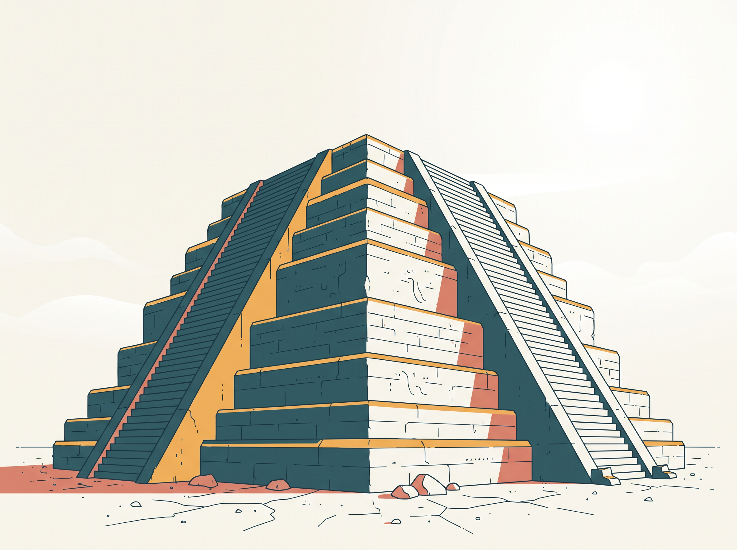
Fig. 7.16 – The mahanavami dibba.
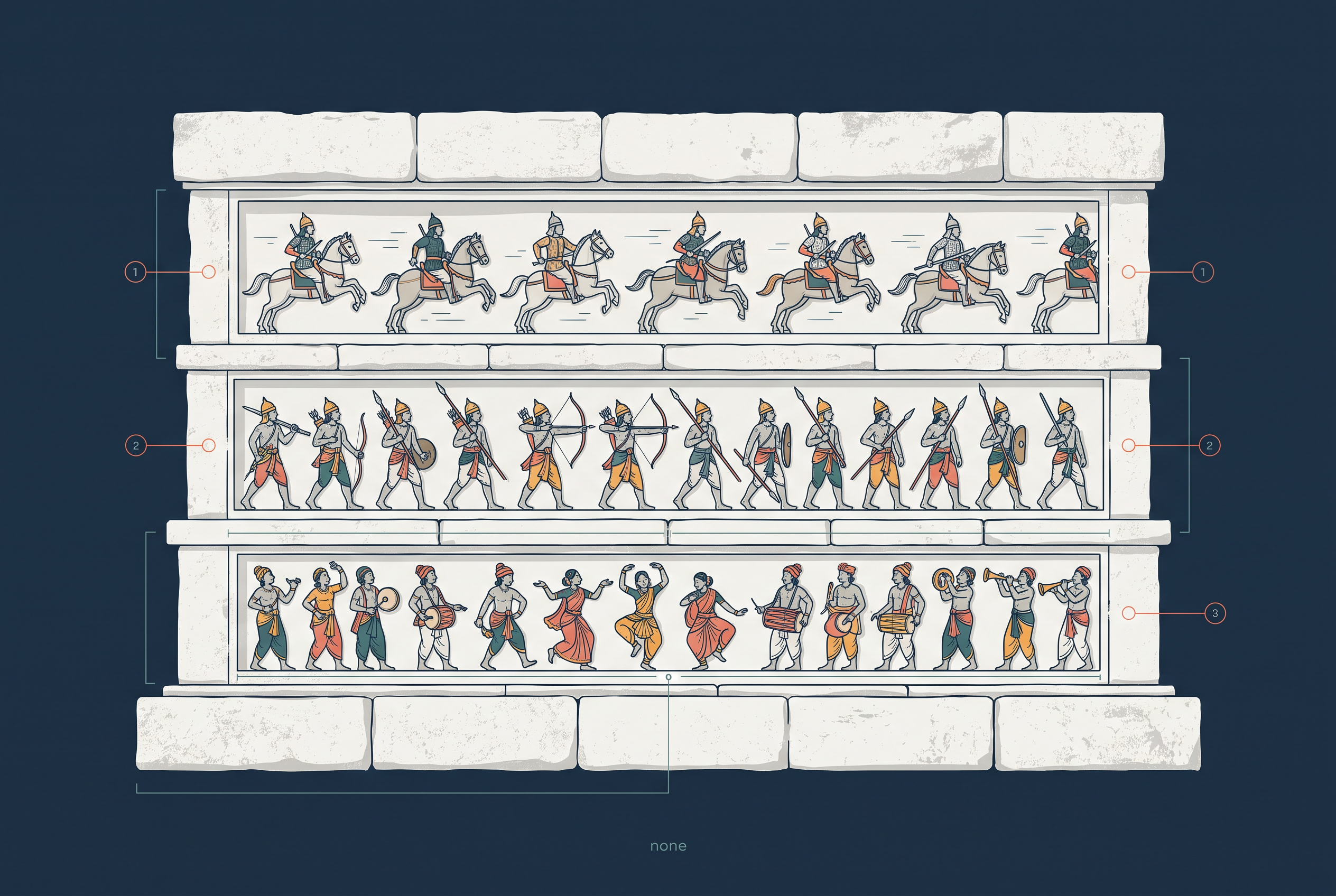
Fig. 7.15 – Carvings on the mahanavami dibba.
The Festival The Platform Is Named For
Rituals associated with the structure probably coincided with Mahanavami — literally, the great ninth day — of the ten-day Hindu festival held during the autumn months of September and October. The same festival is known variously as Dusehra in northern India, Durga Puja in Bengal, and Navaratri or Mahanavami in peninsular India.
On this occasion the Vijayanagara kings displayed their prestige, power and suzerainty. Suzerainty is the claim to be the overlord of other rulers — to have kings beneath you who acknowledge that you stand above them.
The ceremonies performed on the occasion included worship of the image, worship of the state horse, and the sacrifice of buffaloes and other animals. There were dances, wrestling matches, and processions of caparisoned horses — horses dressed in ornamental coverings — along with elephants, chariots and soldiers.
There were also ritual presentations before the king and his guests by the chief nayakas and the subordinate kings. These ceremonies were imbued with deep symbolic meanings. Nothing here was casual; every act said something about who stood where.
On the last day of the festival, the king inspected his army and the armies of the nayakas in a grand ceremony in an open field. On this occasion the nayakas brought rich gifts for the king, as well as the stipulated tribute.
So the festival did in public what the amara-nayaka system needed done. The chiefs came, the tribute was handed over, the armies were counted, and everyone watching could see who commanded whom.
Paes Calls It The House Of Victory
Domingo Paes saw the audience hall and the mahanavami dibba together, and gave them a single name: the ‘House of Victory’. This is what he wrote about them — ‘These buildings have two platforms one above the other, beautifully sculpted … On the upper platform … in this House of Victory the king has a room made of cloth … where the idol has a shrine … and in the other in the middle is placed a dais on which stands a throne of state, (the crown and the royal anklet) …’
Look at what he puts inside these structures: a cloth room, a shrine for the idol, a dais, a throne of state, the crown and the royal anklet. Every one of those things is perishable or portable. Not one of them survives.
An Enigma
And now the honest question the chapter itself asks. Was the ‘mahanavami dibba’ that stands today the centre of this elaborate ritual?
Scholars have pointed out that the space surrounding the structure does not seem to have been adequate for elaborate processions of armed men, women, and large numbers of animals. Like some of the other structures in the royal centre, it remains an enigma — a thing we can measure precisely and still cannot explain.
7.4.2 Other Buildings In The Royal Centre
The Lotus Mahal, And Its Borrowed Name
One of the most beautiful buildings in the royal centre is the Lotus Mahal, so named by British travellers in the nineteenth century. The name is not a Vijayanagara name at all. It was fixed on the building three hundred years after the city was abandoned, by visitors who thought it looked like a lotus.
While the name is certainly romantic, historians are not quite sure what the building was used for. One suggestion, found in a map drawn by Mackenzie, is that it may have been a council chamber — a place where the king met his advisers.
Fig. 7.17 gives an elevation of the Lotus Mahal. An elevation is a vertical view of any object or structure — a drawing of it as seen straight on from the side. It gives you an idea of features that cannot be seen in a photograph. Notice the arches: these were probably inspired by Indo-Islamic techniques.
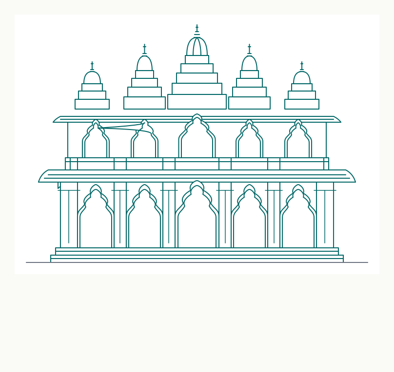
Fig. 7.17 – Elevation of the Lotus Mahal.

Fig. 7.18 – Detail of a Lotus Mahal arch.
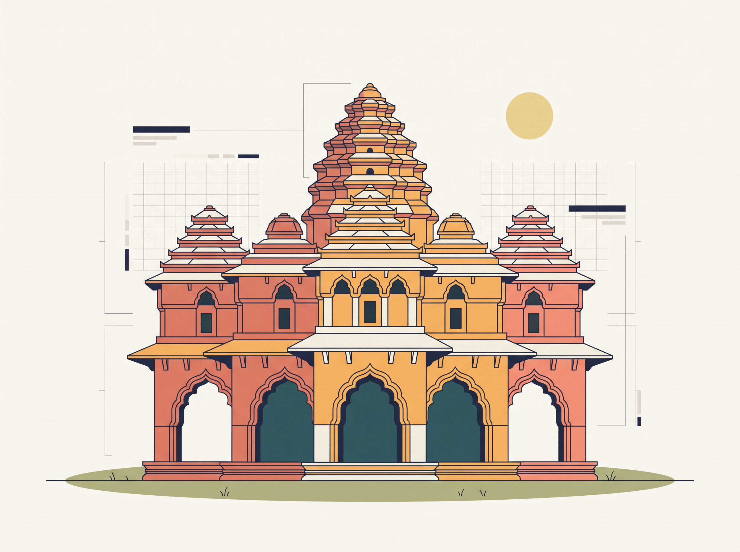
Fig. 7.19 – The Lotus Mahal.
The ‘Elephant Stables’
Close to the Lotus Mahal stands another set of buildings, which have been given a name in exactly the same way — from what they look like they were for.

Fig. 7.21a – Elevation of the elephant stables.
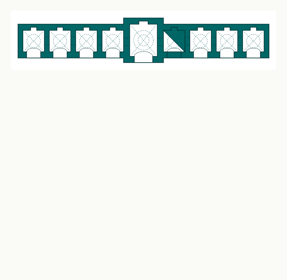
Fig. 7.21b – Plan of the elephant stables.
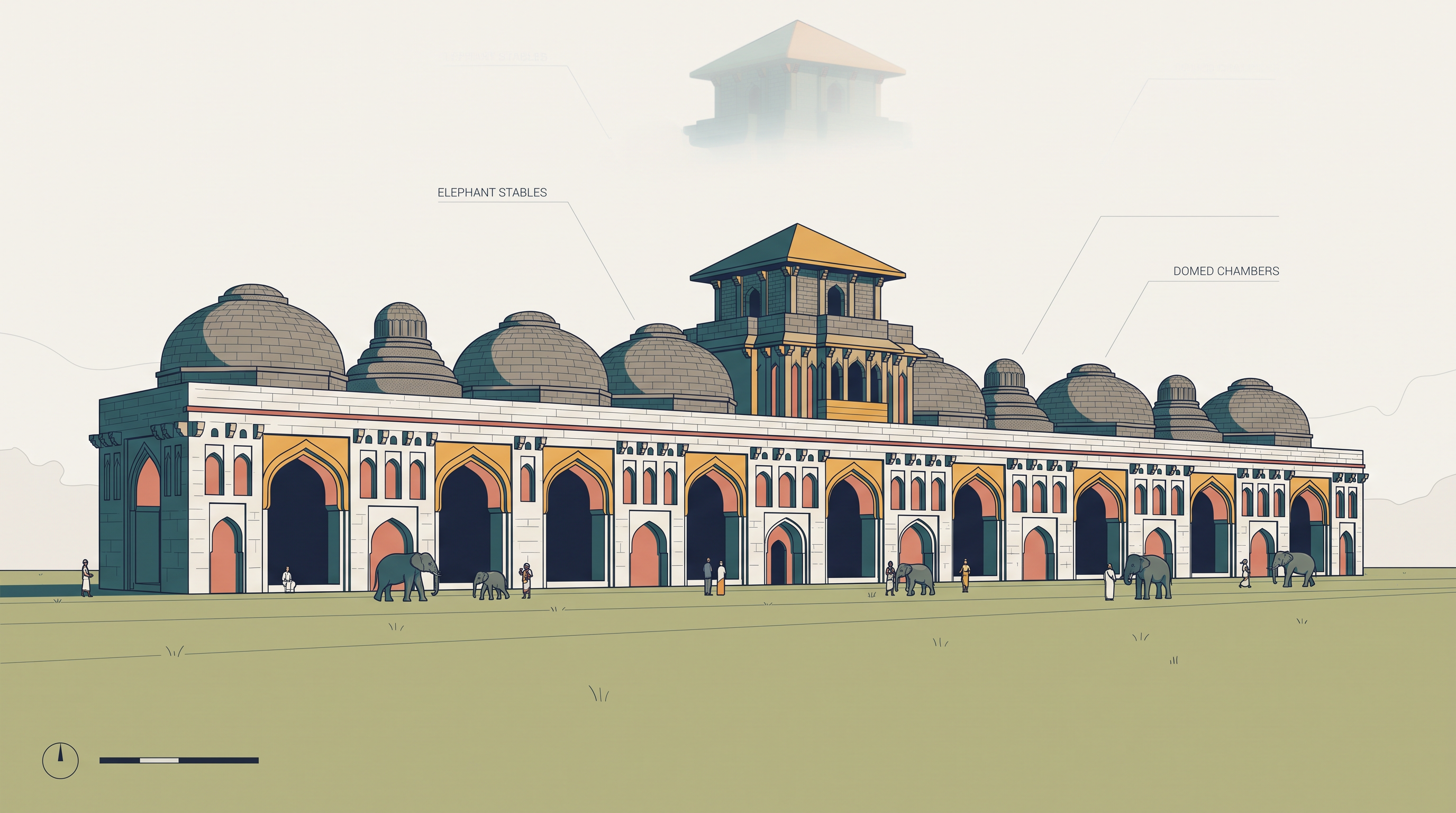
Fig. 7.22 – The elephant stables.
Temples In The King’s Quarter
While most temples were located in the sacred centre, there were several in the royal centre as well. One of the most spectacular of these is the one known as the Hazara Rama temple.
This was probably meant to be used only by the king and his family. A private temple, inside the walls of the royal centre, is itself a statement: the king’s worship was not the city’s worship.
The images in the central shrine are missing. However, sculpted panels on the walls survive, and these include scenes from the Ramayana, sculpted on the inner walls of the shrine.
So the deity has gone, and the storytelling remains. What we can still study is not what was worshipped here, but what the king chose to have carved around the act of worship.
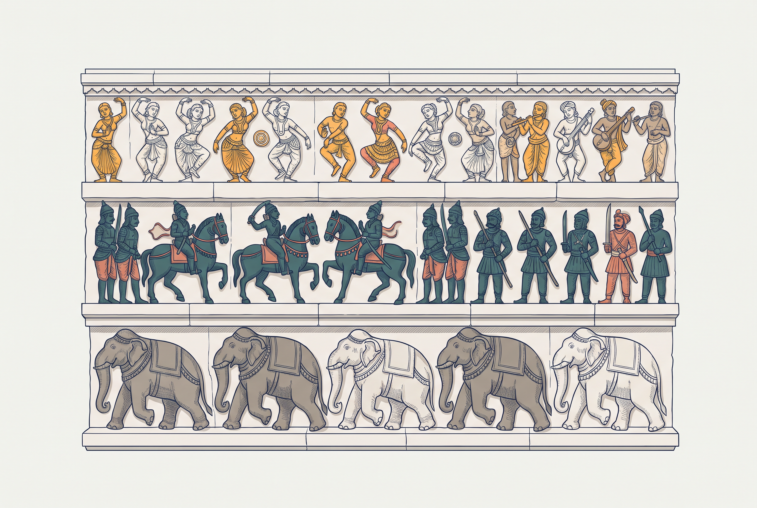
Fig. 7.23 – Sculpture from the Hazara Rama temple.
What Survived The Sack
While many of the structures at Vijayanagara were destroyed when the city was sacked, traditions of building palatial structures were continued by the nayakas. Many of these buildings have survived.
That is a useful thing to know when you look at Fig. 7.24. The audience hall at Madurai is not at Vijayanagara, and it was not built by a raya — yet the arches in it belong to the same building world.
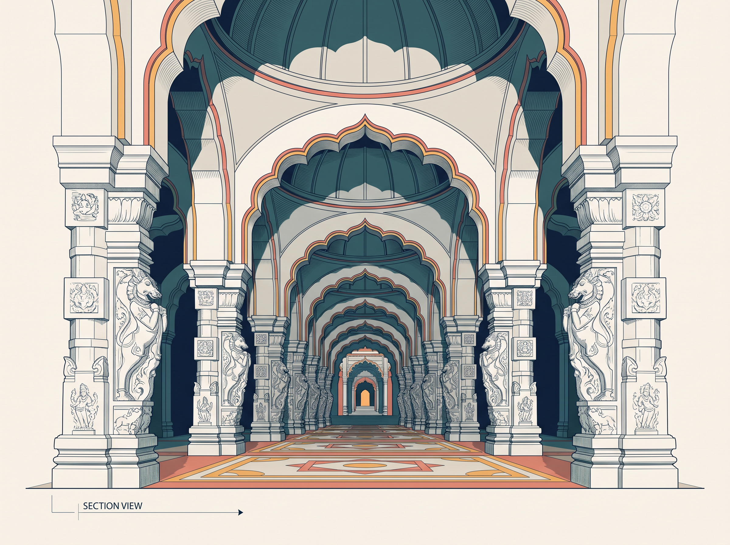
Fig. 7.24 – Interior of the Madurai audience hall.
7.5 The Sacred Centre
We have walked the walls, the roads, the urban core and the royal centre. One zone of the city is left, and on the plan in Fig. 7.14 it lies at the other end of the settlement from the royal centre — across the cultivated valley that the Hiriya canal watered.
This is the sacred centre. It is where the temples of Vijayanagara are concentrated, and where the choice of this site as a capital has to be explained.
Two questions run through everything that follows. Why was a city built here, on this stretch of rock and river, rather than anywhere else? And what did the temples in it actually do for the men who paid for them?
7.5.1 Choosing A Capital
A Landscape Already Sacred
We now move to the rocky northern end of the city, on the banks of the Tungabhadra. Before any king built anything here, this stretch of hills already carried meaning for the people who lived around it.
According to local tradition, these hills sheltered the monkey kingdom of Vali and Sugriva, mentioned in the Ramayana. Other traditions suggest that Pampadevi, the local mother goddess, did penance in these hills in order to marry Virupaksha, the guardian deity of the kingdom, who is also recognised as a form of Shiva. To this day, this marriage is celebrated annually in the Virupaksha temple.
Among these hills are found Jaina temples of the pre-Vijayanagara period as well — shrines of the Jaina tradition, built before the empire existed. In other words, this area was associated with several sacred traditions, not one.
That plural matters. The site was not a blank space that a king made holy. It was a place already thick with stories, already visited, already worshipped at — and the empire was built on top of that.
What A Temple Did For A King
Temple building in the region had a long history, going back to dynasties such as the Pallavas, the Chalukyas, the Hoysalas and the Cholas — the ruling houses of the peninsula in the centuries before Vijayanagara.
Rulers very often encouraged temple building as a means of associating themselves with the divine. Often, the deity was explicitly or implicitly identified with the king. To honour the god was, in some measure, to honour the man who had built the god’s house.
But a temple was never only a place of worship. Temples also functioned as centres of learning. Besides, rulers and others often granted land and other resources for the maintenance of temples — land whose produce paid for the priests, the lamps, the food, the repairs and the festivals.
Consequently, temples developed as significant religious, social, cultural and economic centres. From the point of view of the rulers, constructing, repairing and maintaining temples were important means of winning support and recognition for their power, their wealth and their piety.
Ruling On Behalf Of A God
It is likely that the very choice of the site of Vijayanagara was inspired by the existence of the shrines of Virupaksha and Pampadevi. The city, in other words, may have come to the god rather than the god to the city.
In fact, the Vijayanagara kings claimed to rule on behalf of the god Virupaksha. That is a strong claim, and it was made in the most routine way possible: all royal orders were signed ‘Shri Virupaksha’, usually in the Kannada script.
Think about what that means in practice. Every order that left the court — every grant, every command — went out over a god’s name, not the king’s. The king presented himself not as the source of authority, but as the god’s agent.
Rulers also indicated their close links with the gods by using the title ‘Hindu Suratrana’. This was a Sanskritisation of the Arabic term Sultan, meaning king — that is, an Arabic word given a Sanskrit form. Literally, the title meant Hindu Sultan.
Old Traditions, New Uses
Even as they drew on earlier traditions, the rulers of Vijayanagara innovated and developed them. Two innovations are worth marking.
Royal portrait sculpture was now displayed in temples. The image of the king stood inside the god’s house, where worshippers would see it — and you will meet one such statue later in this chapter.
And the king’s visits to temples were treated as important state occasions, on which he was accompanied by the important nayakas of the empire. A visit to a shrine became a public assembly of the empire’s chiefs, watched by everyone present. Devotion and politics were performed in the same act.
Fig. 7.26 shows the Virupaksha temple from the air. Notice how the temple sits inside a settlement that is still lived in, and how the great gateway rises above everything around it.
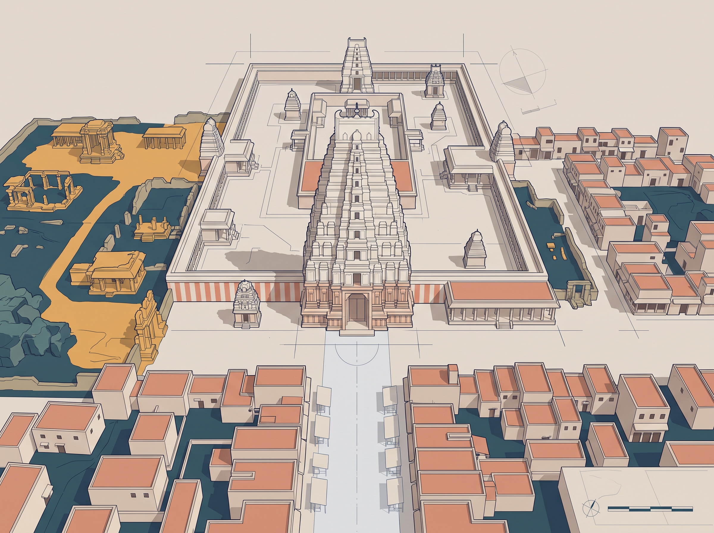
Fig. 7.26 – Aerial view of the Virupaksha temple.
7.5.2 Gopurams And Mandapas
Gateways That Dwarf The Shrine
In terms of temple architecture, by this period certain new features were in evidence. These included structures of immense scale that must have been a mark of imperial authority.
The clearest example is the raya gopurams, or royal gateways, which you have already seen in Fig. 7.25. These often dwarfed the towers on the central shrines, and signalled the presence of the temple from a great distance.
Read that again, slowly. The gateway grew taller than the tower over the god. Whatever else these gateways were doing, they were not modestly pointing to the shrine behind them.
They were also probably meant as reminders of the power of kings — kings able to command the resources, the techniques and the skills needed to construct such towering gateways. Stone had to be quarried and hauled; skilled sculptors had to be found and fed for years. A gopuram is a public account of what a ruler could summon.
Other distinctive features include mandapas, and long, pillared corridors that often ran around the shrines within the temple complex. Let us look at two temples more closely — the Virupaksha temple and the Vitthala temple.
The Virupaksha Temple, Built Over Centuries
The Virupaksha temple was built over centuries — and that phrase, not any single date, is the key to understanding it.
Inscriptions suggest that the earliest shrine dated to the ninth-tenth centuries. It was substantially enlarged with the establishment of the Vijayanagara Empire, four or five hundred years later.
The hall in front of the main shrine was built by Krishnadeva Raya to mark his accession — the moment a ruler comes to the throne. It was decorated with delicately carved pillars. He is also credited with the construction of the eastern gopuram.
These additions meant that the central shrine came to occupy a relatively small part of the complex. The oldest and holiest part of the temple ended up as a small element inside a much larger set of buildings — because every ruler who added something added it outwards.
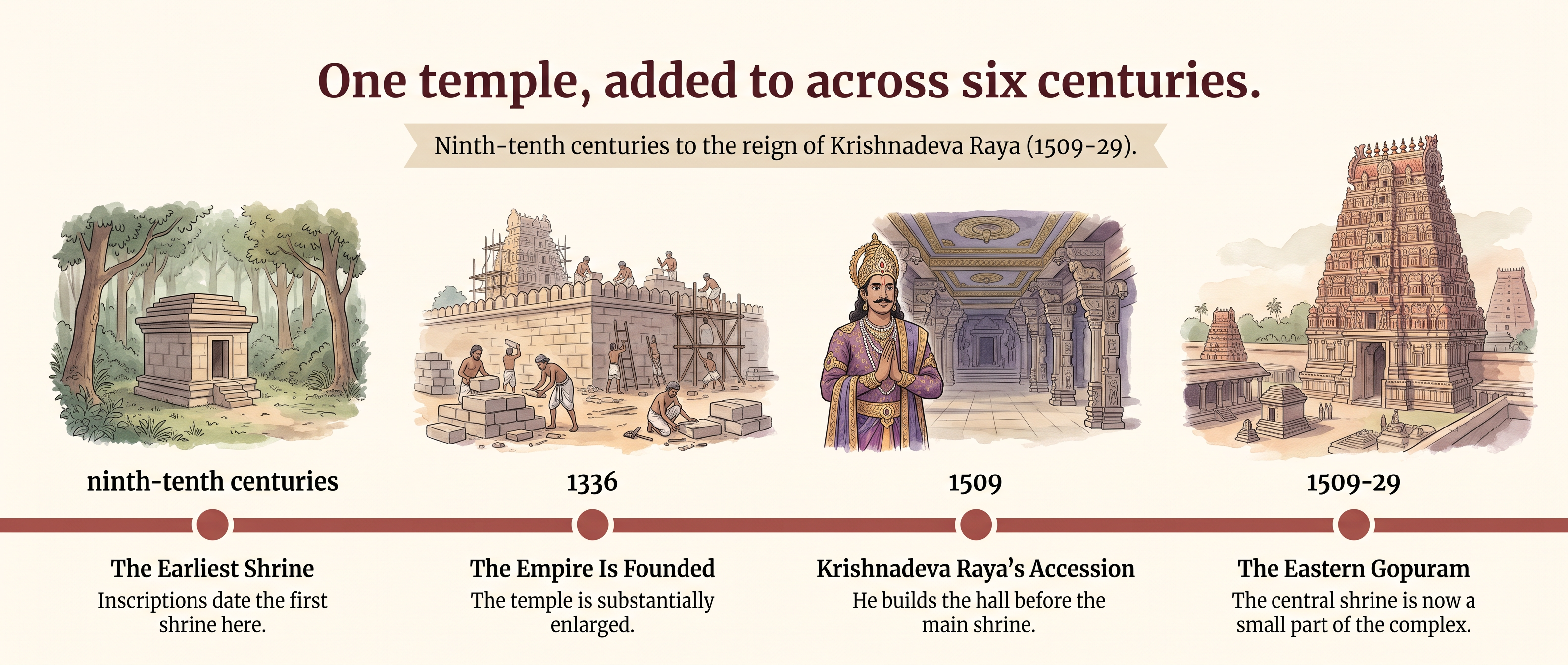
Fig. 7.27 – The Virupaksha temple grows.
Fig. 7.28 gives the plan of the temple. Use it, because a plan shows you what a photograph cannot: how the parts are arranged in relation to one another.
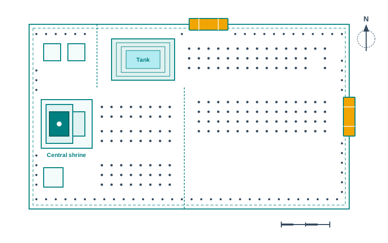
Fig. 7.28 – Plan of the Virupaksha temple.
What The Halls Were For
The halls in the temple were used for a variety of purposes, and the list is worth taking seriously, because it shows how much of life a temple held.
Some were spaces in which the images of gods were placed to witness special programmes of music, dance, drama and the like. Others were used to celebrate the marriages of deities. Yet others were meant for the deities to swing in.
Special images, distinct from those kept in the small central shrine, were used on these occasions. So the god of the inner shrine stayed where he was, and other images went out to the halls to be married, entertained and swung.
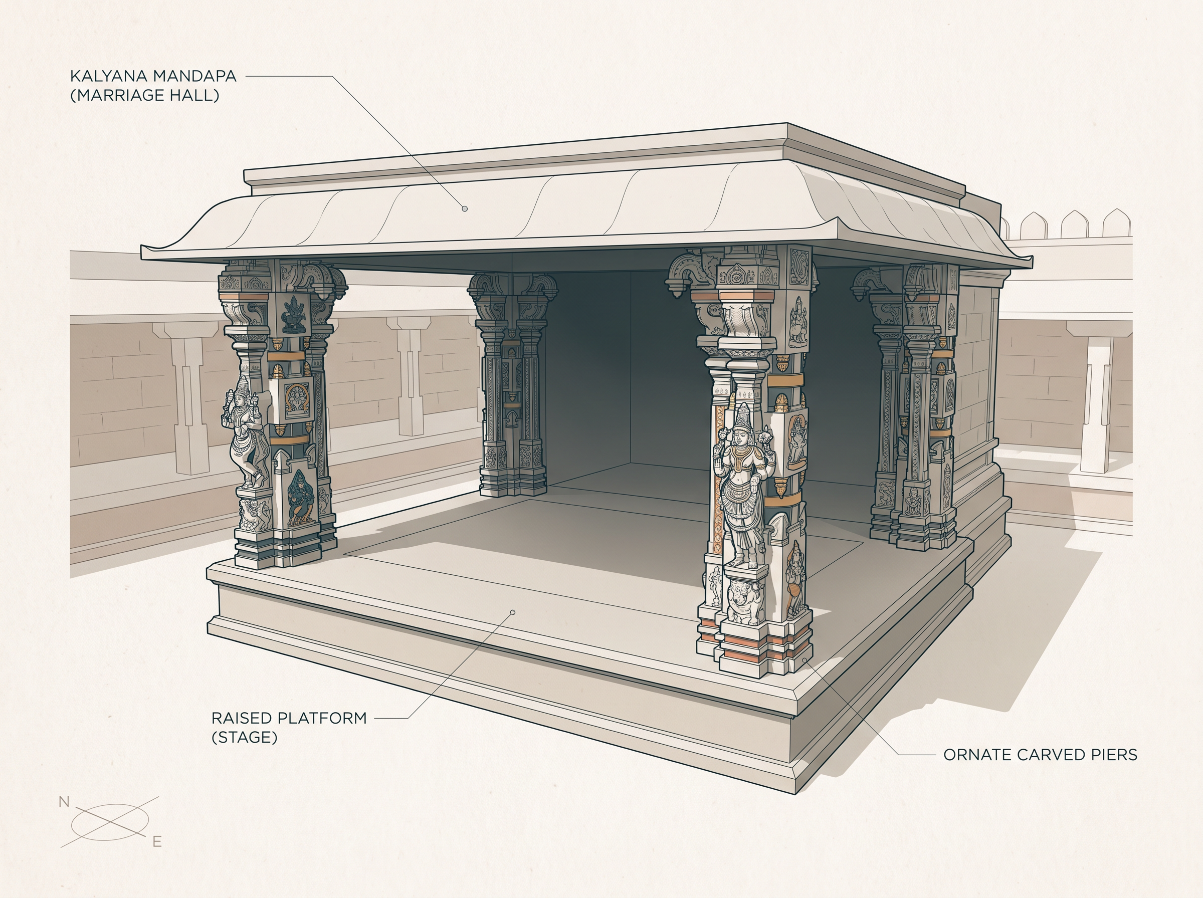
Fig. 7.29 – A kalyana mandapa.
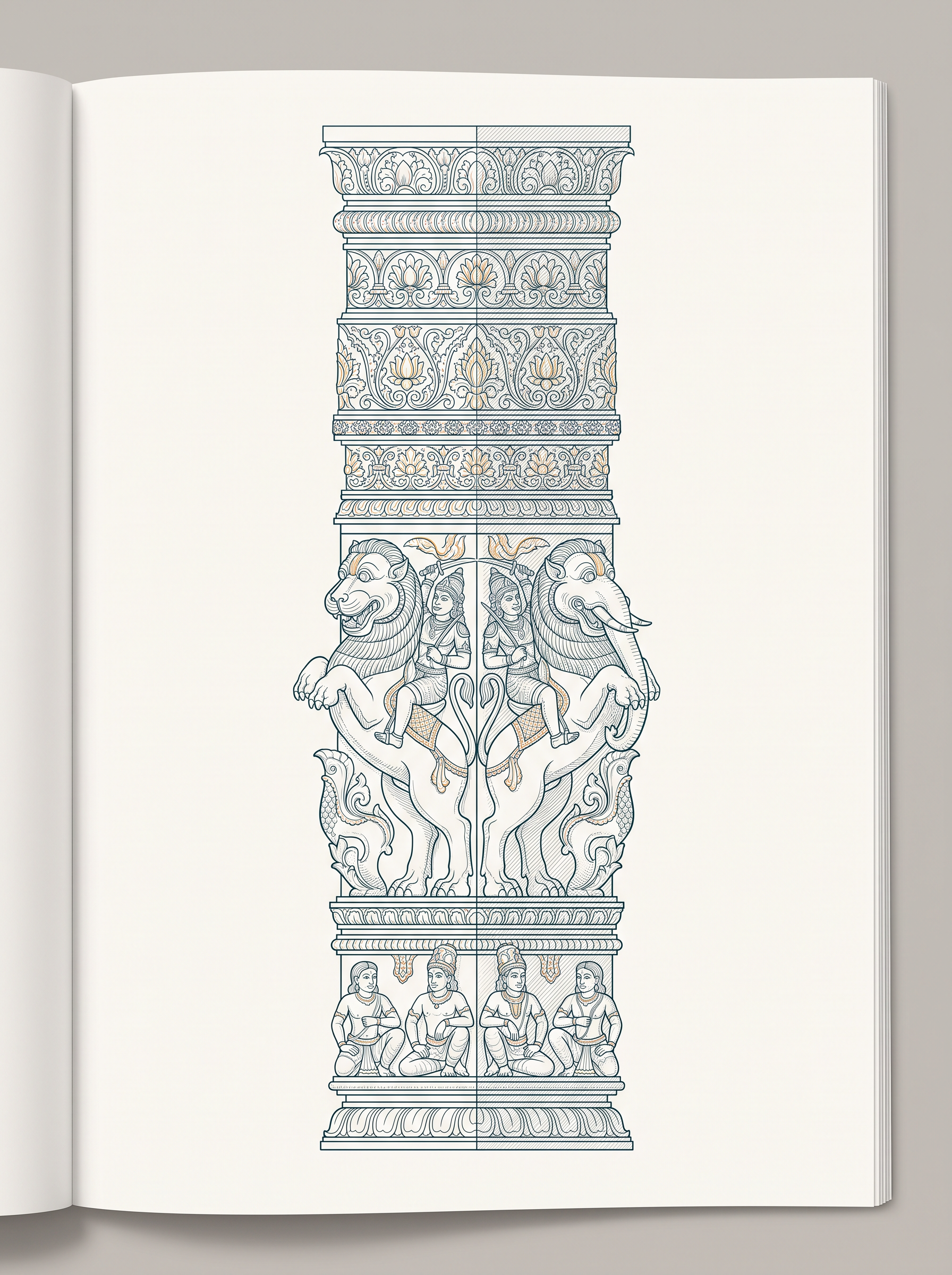
Fig. 7.30 – A sculpted pillar.
The Vitthala Temple, And A Borrowed God
Another shrine, the Vitthala temple, is also interesting. Here, the principal deity was Vitthala, a form of Vishnu generally worshipped in Maharashtra, to the north-west of the empire.
The introduction of the worship of this deity in Karnataka is another indication of the ways in which the rulers of Vijayanagara drew on different traditions to create an imperial culture.
Set that beside what you already know. They took building techniques from the Turkish Sultans, a title from Arabic, and now a god from Maharashtra. An imperial culture, as this chapter keeps showing, is assembled from elsewhere.
As in the case of other temples, this temple too has several halls, and a unique shrine designed as a chariot.
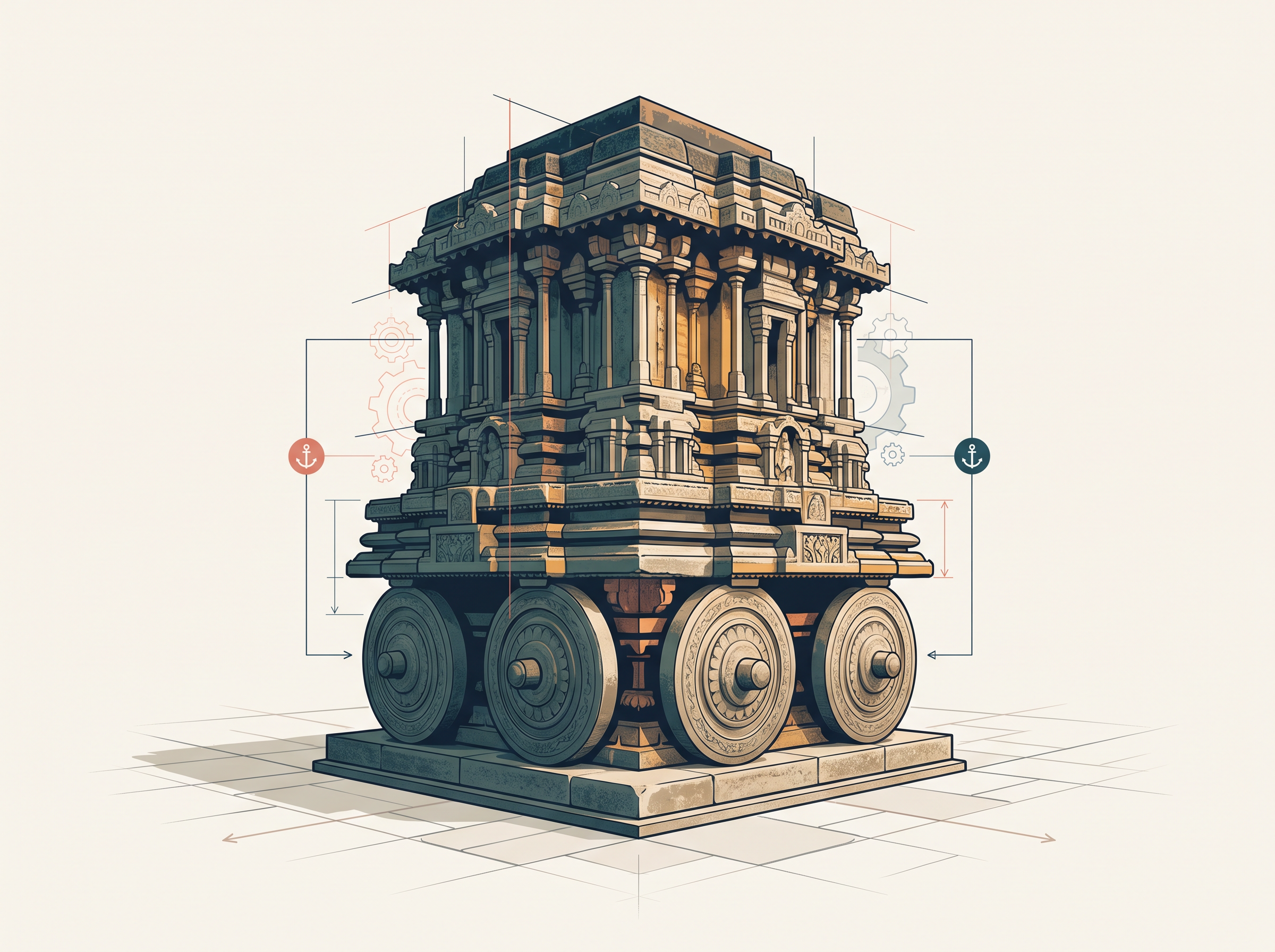
Fig. 7.31 – Chariot of the Vitthala temple.
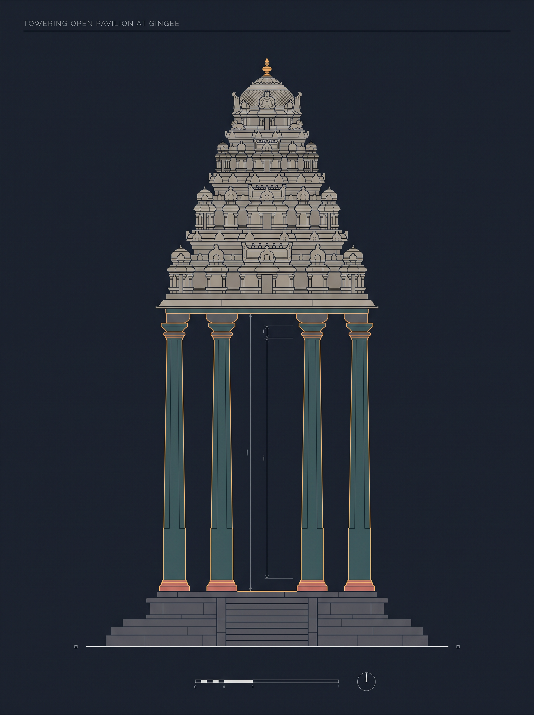
Fig. 7.32 – Swing pavilion at Gingee.
Streets That Ran Out Of Temples
A characteristic feature of the temple complexes is the chariot streets that extended from the temple gopuram in a straight line.
These streets were paved with stone slabs, and lined with pillared pavilions in which merchants set up their shops. So the road out of the temple gate was also the marketplace — a fact that fits exactly with what you read earlier about roads extending from temple gateways and being lined by bazaars.
The Nayakas Build Too
Just as the nayakas continued with and elaborated on traditions of fortification, so they did with traditions of temple building. In fact, some of the most spectacular gopurams were also built by the local nayakas.
That is worth pausing on. The great gateway was a mark of imperial authority — and the chiefs who broke away from the empire went on raising them. The style outlived the state that invented it.
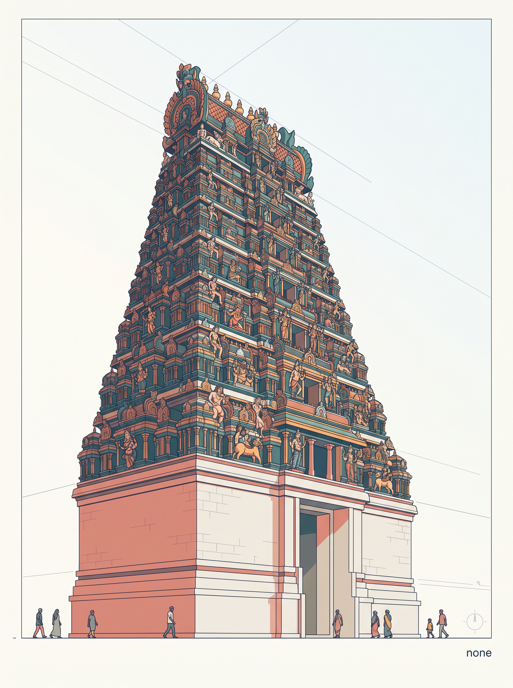
Fig. 7.33 – A nayaka-built gopuram at Madurai.
7.6 Plotting Palaces, Temples And Bazaars
Where All This Information Came From
We have been examining a wealth of information on Vijayanagara — photographs, plans, elevations of structures, and sculpture. It is time to ask the question the chapter has been building towards. How was all of this produced?
After the initial surveys by Mackenzie, information was pieced together from travellers’ accounts and inscriptions. Through the twentieth century, the site was preserved by the Archaeological Survey of India and the Karnataka Department of Archaeology and Museums — the state bodies responsible for protecting, recording and conserving India’s ancient sites.
In 1976, Hampi was recognised as a site of national importance. Then, in the early 1980s, an important project was launched to document the material remains at Vijayanagara in detail, through extensive and intensive surveys, using a variety of recording techniques. Over nearly twenty years, dozens of scholars from all over the world worked to compile and preserve this information.
Twenty years, for one site. That is what stands behind a single caption in this chapter.
Cutting The Ground Into Squares
Let us look at just one part of this enormous exercise — mapping — in more detail.
The first step was to divide the entire area into a set of 25 squares, each designated by a letter of the alphabet. Then each of the small squares was subdivided into a set of even smaller squares. But this was not all: each of these smaller squares was further subdivided into yet smaller units.
Map
Fig. 7.34 Caption: A detailed map of the site. Brief: Reproduce the NCERT map with its grid of 25 lettered squares, the contour lines, the course of the river, the scale bar, the north arrow and the settlements marked, including Hampi, Anegondi, Kamalapuram, Kadirampuram, Nagenahalli, Anantasayanagudi, Hospet and Gangawati. This is a site map of a past landscape; carry no present-day boundaries on it.
Map
Fig. 7.35 Caption: Square N of Fig. 7.34. Brief: Reproduce the NCERT map of square N, subdivided into its own lettered squares (NA to NZ, MK, MP and so on), with the contours, the scale bar and the north arrow as printed.
Map
Fig. 7.36 Caption: Square NM of Fig. 7.35. Brief: Reproduce the NCERT map of square NM, further subdivided into small lettered units, with the contour lines, the numbered structures, the traces of paths and the scale bar as printed.
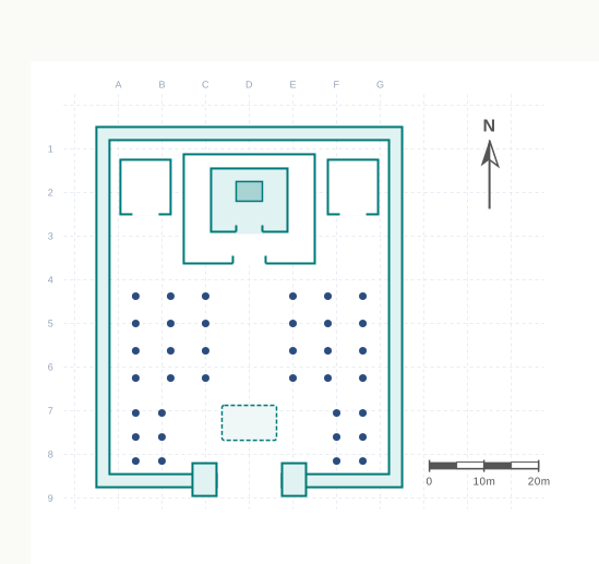
Fig. 7.37 – Plan of the excavated temple.
What The Surveys Recovered
These detailed surveys have been extremely painstaking. They have recovered and documented traces of thousands of structures — from tiny shrines and residences to elaborate temples.
They have also led to the recovery of traces of roads, paths and bazaars. The bazaars have been located through finds of pillar bases and platforms — all that remain of thriving markets.
Consider what that sentence is admitting. A market is people, noise, goods, money and argument. What is left of it is the stumps of pillars and a stone floor. The archaeologist finds the floor, and has to reason her way back to the market.
Imagining What Has Vanished
It is worth remembering something that John M. Fritz, George Michell and M.S. Nagaraja Rao, who worked for years at the site, wrote: ‘In our study of these monuments of Vijayanagara we have to imagine a whole series of vanished wooden elements – columns, brackets, beams, ceilings, overhanging eaves, and towers – decorated with plaster and painted, perhaps brightly.’
That is a warning about the ruins, and it applies to every photograph in this chapter. The grey, bare stone you are looking at is not what the people of Vijayanagara saw. They saw wood, plaster and paint on top of that stone — and none of it is there now.
Although wooden structures are lost, and only stone structures survive, the descriptions left by travellers allow us to reconstruct some aspects of the vibrant life of the times.
The Bazaar, As The Travellers Saw It
Source 5 is where the bare stone floor fills up again with people. Paes and Nuniz were both Portuguese visitors, both astonished, and both writing about markets they had walked through themselves.
Now set Source 5 beside the pillar bases. The archaeologist finds a line of stone stumps. Paes tells you that gems, cloth, horses, fruit and firewood were sold along that line, and that a fair was held there every evening.
Neither kind of evidence could have done this alone. The stone gives you the place; the traveller gives you the life. This is exactly the collating of one source against another that the study of Vijayanagara has depended on since Mackenzie’s day.
But handle the abundance with care. Paes calls it the best-provided city in the world, and Nuniz says everything was very cheap. Both were foreign visitors, impressed, and describing the markets of a capital at its height. Whether food was in fact cheap for the poorest people of the city, neither of them can tell us.
7.7 Questions In Search Of Answers
What A Building Can Tell You
Buildings that survive tell us about the way spaces were organised and used, how they were built, and with what materials and techniques. This whole chapter has been a demonstration of that.
For example, we can assess the defence requirements and the military preparedness of a city by studying its fortifications. Seven lines of forts, walls without mortar, fields enclosed against a siege — from stone alone, we learned what the rulers of Vijayanagara feared and how they planned to survive it.
Buildings also tell us about the spread of ideas and cultural influences, if we compare them with buildings in other places. The arch and the dome over a fort gate mean something only because we can point to where else such arches and domes were built.
They convey ideas which the builders or their patrons wished to project. And they are often suffused with symbols which are a product of their cultural context. These we can understand when we combine information from other sources — literature, inscriptions and popular traditions.
That last sentence is the method of this chapter in a single line. A building on its own is mute. It begins to speak when it is set beside an inscription, a traveller’s account, a poem, or a story people still tell.
The People Who Are Missing
Now the chapter turns, honestly, on itself.
Investigations of architectural features do not tell us what ordinary men, women and children — who made up the vast majority of the people who lived in the city and its outskirts — thought about these impressive buildings.
Would they have had access to any of the areas within the royal centre or the sacred centre? Would they hurry past the sculpture, or would they pause, reflect, and try to understand its complicated symbolism? And what did the people who worked on these colossal construction projects think of the enterprises to which they had contributed their labour?
These are not decorative questions. They are the questions the evidence cannot answer, and the textbook prints them rather than pretending otherwise.
Who Actually Built It
Rulers took all the important decisions about the buildings to be constructed — the site, the material to be used, and the style to be followed. Everything after that decision was done by other people, and about those people we know very little.
Who possessed the specialised knowledge required for such enormous enterprises? Who drew up the plans for the buildings? Where did the masons, the stonecutters and the sculptors who did the actual building come from? Were they captured during war from neighbouring regions? What kind of wages did they get? Who supervised the building activity? How was building material transported, and where did it come from?
These are some of the questions that we cannot answer by merely looking at the buildings or their remains. Continuing research, using other sources, might provide some further clues.
Remember Paes at the tank, watching fifteen or twenty thousand men at work and comparing them to ants. That is almost the closest this chapter can get to the workers of Vijayanagara — an admiring foreigner, describing them from a distance, as a crowd.
Two Portraits Of One King
To recapitulate about some of the problems of perspective, look at Fig. 7.38 — a statue of Krishnadeva Raya, placed on the gopuram of the temple at Chidambaram, in Tamil Nadu. This is obviously the way in which the ruler wanted to project himself.
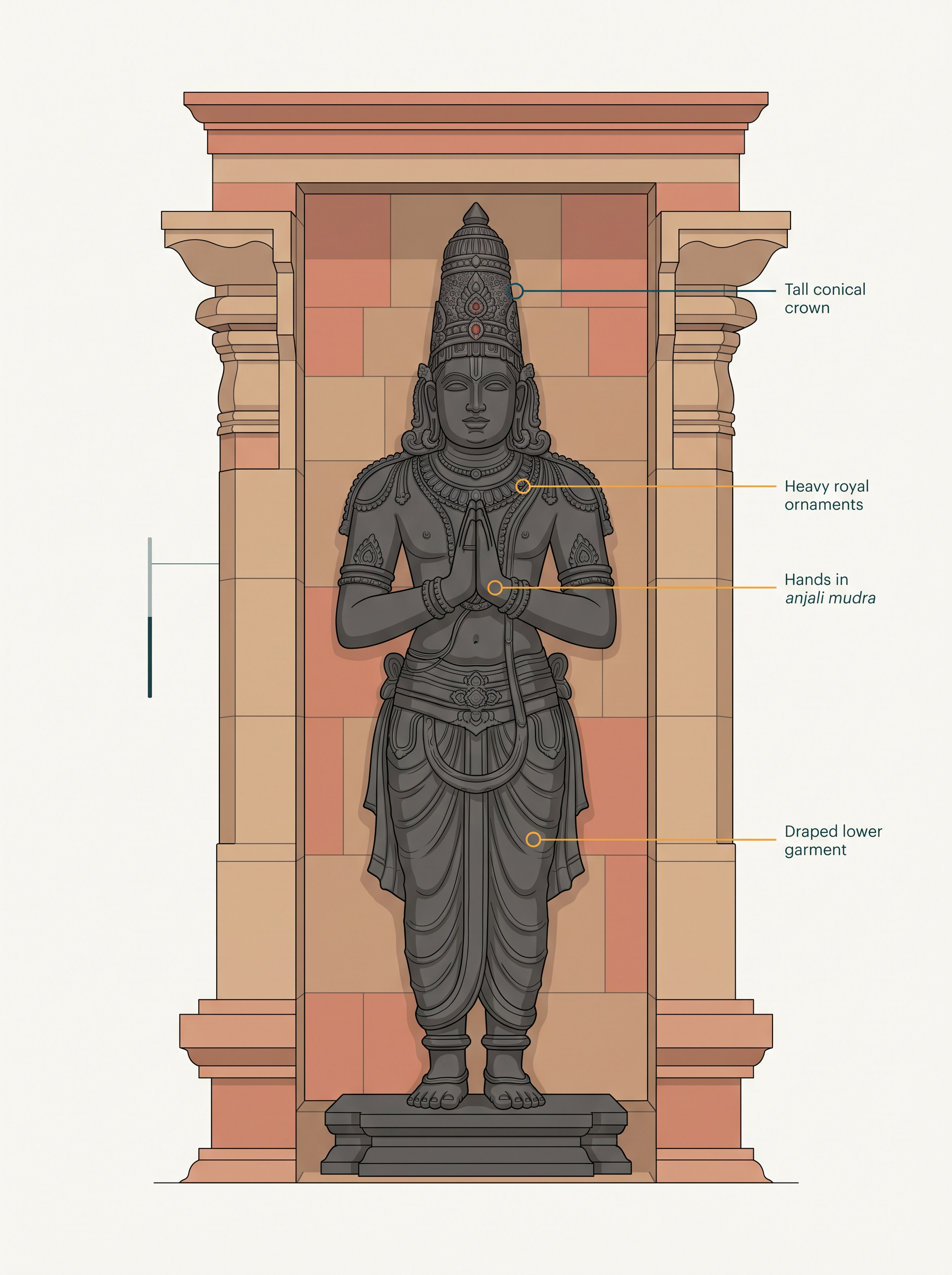
Fig. 7.38 – Statue of Krishnadeva Raya at Chidambaram.
And this is how Paes describes the king: ‘Of medium height, and of fair complexion and good figure, rather fat than thin; he has on his face signs of smallpox.’
Put the two side by side. The statue shows a king as a king wished to be shown — upright, ideal, placed high on a temple gateway where worshippers would look up at him. Paes gives you a man of medium height, running to fat, his face marked by a disease he had survived.
Neither is a lie. But they were made for different reasons, and that is the whole lesson. A royal image is an argument about power. A traveller’s note is an impression, filtered through what he found worth mentioning.
Fig. 7.39 shows one more structure of the royal centre, and it carries the same difficulty in its very name.
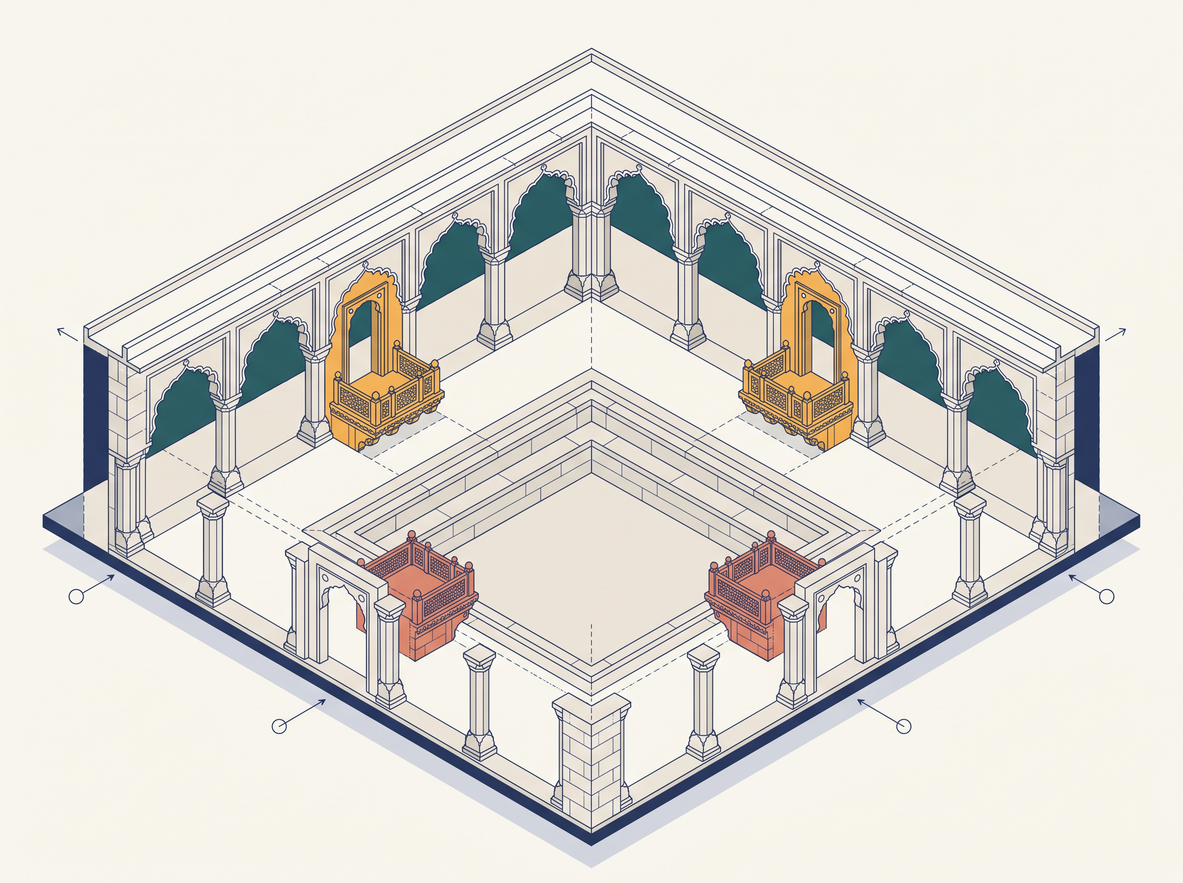
Fig. 7.39 – The queen’s bath.
‘Known as’ the queen’s bath — like the Lotus Mahal, like the elephant stables, like the king’s palace itself. The name comes from us, not from them. What the building was, and who used it, is one more question still in search of an answer.
7.8 Summary
What This Chapter Established
- Vijayanagara, ‘city of victory’, was the name of both a city and an empire. The empire was founded in the fourteenth century and stretched, at its height, from the Krishna to the southern tip of the peninsula.
- The city was sacked in 1565 and deserted soon after, but it survived in local memory as Hampi, named after the mother goddess Pampadevi.
- The modern study of the site begins in 1800 with Colin Mackenzie, a Company surveyor whose first information came from the priests of the Virupaksha temple and Pampadevi’s shrine.
- Its history has been reconstructed by collating oral tradition, monuments, inscriptions collected from 1836, photographs from 1856, travellers’ accounts, and literature in Telugu, Kannada, Tamil and Sanskrit.
- Tradition and epigraphic evidence credit the founding to two brothers, Harihara and Bukka, in 1336. Contemporaries called the state the karnataka samrajyamu.
- The rayas competed with the Deccan Sultans and the Gajapatis of Orissa for river valleys and overseas trade — and borrowed building techniques from the same rivals.
- Cavalry decided warfare, so horses were imported from Arabia and Central Asia; the Portuguese entered this trade from 1498 with muskets and trading stations.
- Krishnadeva Raya (1509-29) marked the empire’s height; in the Amuktamalyada he advised kings to improve harbours and keep foreign merchants attached to themselves.
- The amara-nayaka system gave military commanders territories to govern; they kept revenue, maintained horses and elephants, funded temples and irrigation, and sent annual tribute.
- In 1565, Rama Raya was routed at Rakshasi-Tangadi by Bijapur, Ahmadnagar and Golconda. Relations between rayas and Sultans had never been simply hostile; it was Rama Raya’s policy of playing one Sultan against another that united them.
- In an arid basin, water was caught and held: embankments, reservoirs, the Kamalapuram tank, the Hiriya canal and aqueducts carried it to fields, sacred centre and royal centre.
- Seven lines of forts enclosed not only the city but its fields and forests — an expensive answer to the siege, which was designed to starve a city out.
- The walls used wedge-shaped blocks and no mortar; gateways carried arches and domes in the Indo-Islamic style.
- Ordinary people’s houses were thatched and have not survived; Chinese porcelain marks the quarter of rich traders and the Muslim residential area.
- The royal centre held over 60 temples and about thirty complexes identified as palaces; the mahanavami dibba and the audience hall remain enigmas.
- At the Mahanavami festival the king displayed prestige, power and suzerainty, inspected the armies, and received gifts and tribute from the nayakas.
- The sacred centre was chosen where the shrines of Virupaksha and Pampadevi already stood; royal orders were signed ‘Shri Virupaksha’ and kings used the title ‘Hindu Suratrana’.
- Raya gopurams dwarfed the shrines they guarded; mandapas, pillared corridors and chariot streets lined with shops completed the temple complexes — and the nayakas went on building both forts and gopurams.
- From the early 1980s, a twenty-year project mapped the site square by square, recovering thousands of structures, and the bazaars survive only as pillar bases and platforms.
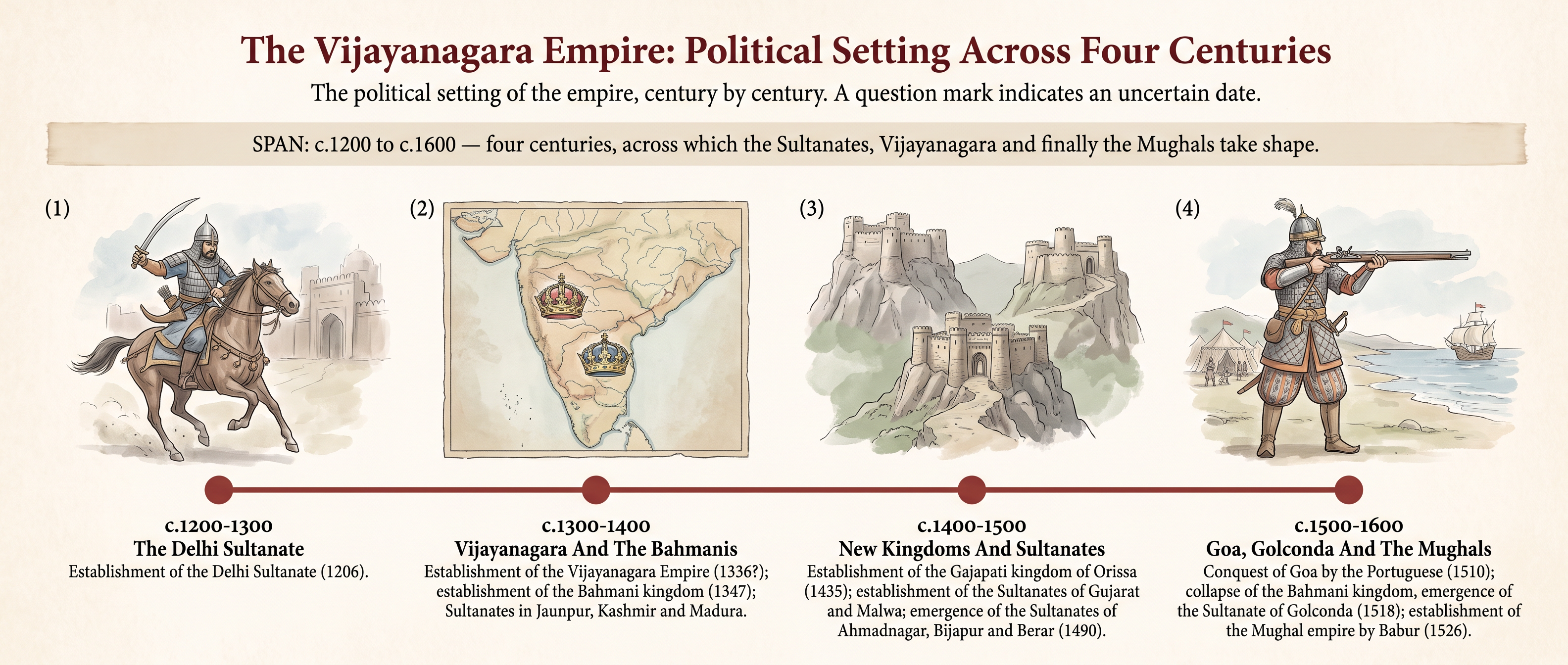
Fig. 7.40 – Major political developments.
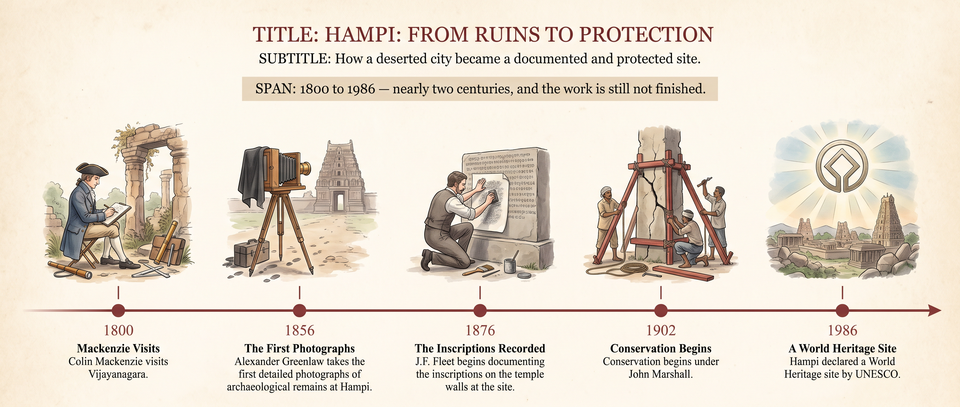
Fig. 7.41 – Discovery and conservation of Vijayanagara.
What The Evidence Cannot Tell Us
The people of Vijayanagara are largely missing from Vijayanagara. Their houses were thatched and have rotted away; their bazaars survive as pillar stumps; and no inscription was ever cut to record what a stonecutter earned, or where the masons and sculptors came from.
The sources we do have were made by people with reasons. Inscriptions record what kings and nayakas wished remembered. Travellers wrote down what astonished them. A royal statue shows a ruler as he wished to be seen, and a chronicle of statecraft tells us what a king thought good policy was — not what actually happened in his ports.
So the buildings can tell us how a wall was built, and never what the man who built it thought of the enterprise. That silence is not a gap the chapter forgot to fill. It is the honest edge of what this evidence can reach.
7.9 NCERT Questions
What have been the methods used to study the ruins of Hampi over the last two centuries? In what way do you think they would have complemented the information provided by the priests of the Virupaksha temple? (in about 100-150 words)
How were the water requirements of Vijayanagara met? (in about 100-150 words)
What do you think were the advantages and disadvantages of enclosing agricultural land within the fortified area of the city? (in about 100-150 words)
What do you think was the significance of the rituals associated with the mahanavami dibba? (in about 100-150 words)
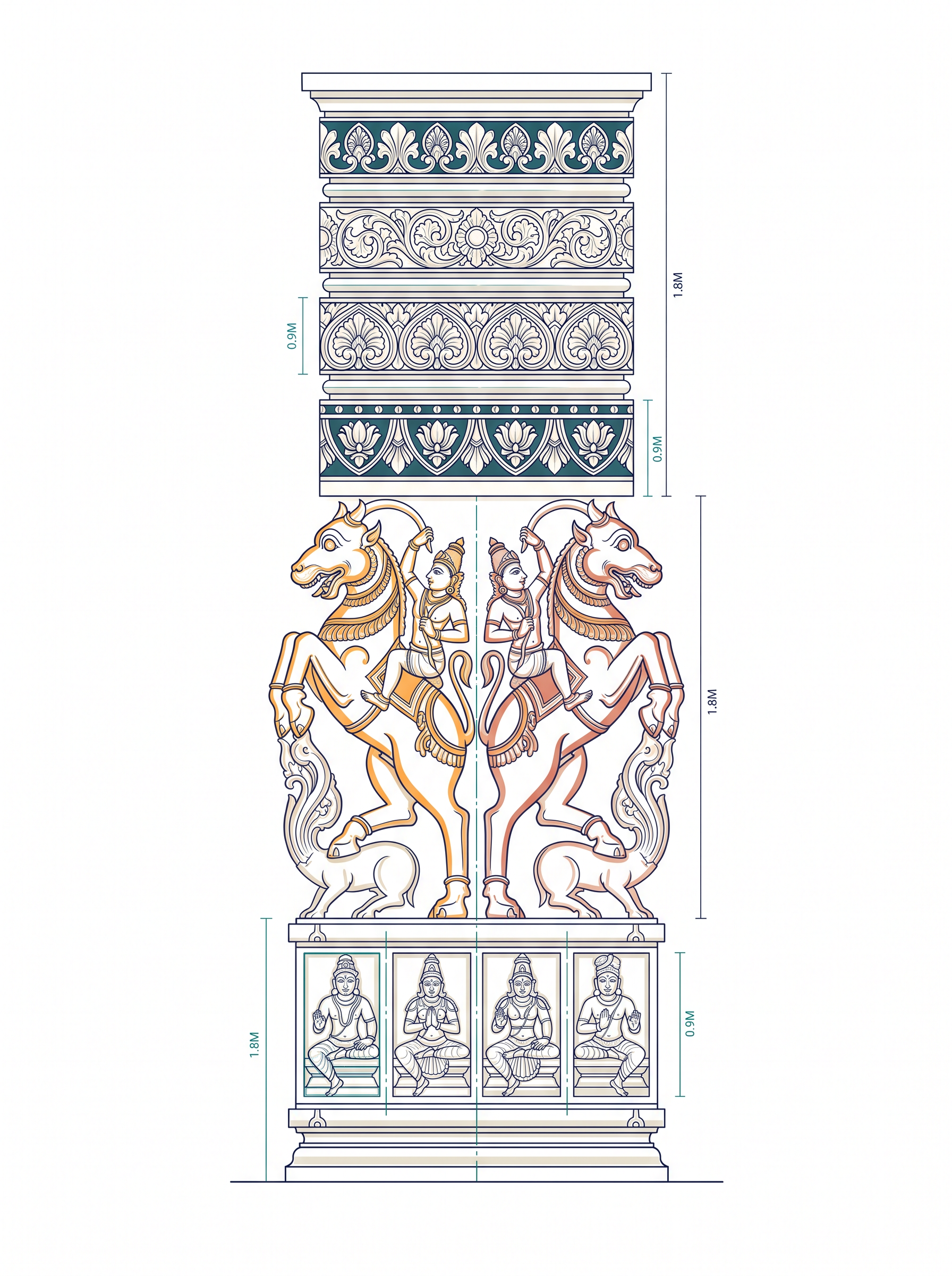
Fig. 7.42 – Pillar from the Virupaksha temple.
Fig. 7.42 is an illustration of another pillar from the Virupaksha temple. Do you notice any floral motifs? What are the animals shown? Why do you think they are depicted? Describe the human figures shown. (in about 100-150 words)
Discuss whether the term ‘royal centre’ is an appropriate description for the part of the city for which it is used. (in about 250-300 words)
What does the architecture of buildings like the Lotus Mahal and the elephant stables tell us about the rulers who commissioned them? (in about 250-300 words)
What are the architectural traditions that inspired the architects of Vijayanagara? How did they transform these traditions? (in about 250-300 words)
What impression of the lives of the ordinary people of Vijayanagara can you cull from the various descriptions in the chapter? (in about 250-300 words)
On an outline map of the world, mark approximately Italy, Portugal, Iran and Russia. Trace the routes the travellers mentioned in this chapter would have taken to reach Vijayanagara.
Find out more about any one of the major cities which flourished in the subcontinent during c. fourteenth-seventeenth centuries. Describe the architecture of the city. Are there any features to suggest that these were political centres? Are there buildings that were ritually significant? Is there an area for commercial activities? What are the features that distinguish the urban layout from that of surrounding areas?
7.10 Check Your Concepts
Look again at the shards of Chinese porcelain in Fig. 7.43. Archaeologists have used them to suggest that rich traders lived in the north-eastern corner of the urban core. Set out the reasoning that leads from the shards to that conclusion, and then state one reason why the conclusion cannot be certain.
In Source 2, Krishnadeva Raya advises a king to look after foreign sailors and to allow merchants decent profits. Explain what the king expects to gain from this generosity. Why does he end by saying that those articles will then never go to your enemies?
Explain how the amara-nayaka system gave the rayas an effective fighting force, and how the same system helped bring down the central imperial structure in the seventeenth century.
The chapter says that relations between the rayas and the Deccan Sultans were not always or inevitably hostile. Using the evidence given in the chapter, explain what finally led the Sultanates to combine against Vijayanagara in 1565.
Read Source 1. What did Colin Mackenzie believe the East India Company would gain from studying Vijayanagara? How should knowing his purpose change the way we use the information he collected?
Scholars have questioned whether the mahanavami dibba that stands today was really the centre of the great ritual described in the chapter. What is their reason for doubting it? What kind of new evidence would help settle the question?
The chapter lists several questions about the builders of Vijayanagara — where the masons and sculptors came from, what wages they were paid, who supervised them — that it cannot answer. Explain why the surviving evidence, such as inscriptions, buildings and travellers’ accounts, is unable to answer them.